

School Assignments for Class 12 Geography: India People And Economy Chapter 04 Water Resources
Explore structured practice materials through the CBSE Class 12 Geography Water Resources Assignment Set 01. Tailored for Class 12 learners, utilizing these Geography assignments ensures thorough preparation and strengthens foundational knowledge before final CBSE evaluations.
Practice Class 12 Geography Assignments: India People And Economy Chapter 04 Water Resources
View or download the dedicated CBSE Class 12 Geography Water Resources Assignment Set 01 resource below. Engaging with these assignments under focused study conditions ensures continuous academic progress and mastery of the 2026-27 curriculum.
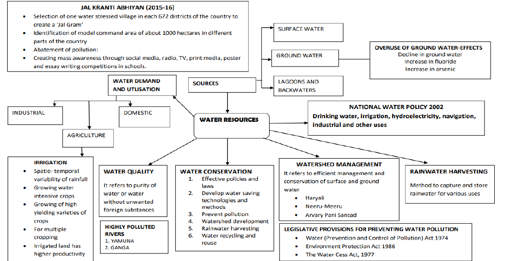
GIST OF THE LESSON WATER RESOURCE IN INDIA
- India accounts 2.45% of world surface area
- 4% of world water resource
- 16% of population
- Total water available from precipitations 4000 cubic km.
- Surface water and replenish able water is 1869 cubic km
- 60% only useful is about 1122 cu.km
SURFACE WATER RESOURCES
- There are four major sources of surface water
- River, lake, ponds, tanks
- 10,360 rivers are present with more than 1.6 km length each
- Mean annual rainfall is about 1869 cubic km
- 60% only usable it is equal to 1122cubic.km
SURFACE WATER RESOURCES
- Four major sources of surface water
- River, lakes, ponds, tanks
- There are 10,360 river with the length of more 1.6 km
- There is about 1869 cu, km of water is available
- Only 690 cu ,km usable
GROUND WATER RESOURCES
- Total replenishable ground water is 432 cu.km
- 46% available from Ganga and Brahmaputra river basins
- Level of utilization of ground water is high in NW and south India
- Low in CHHATTISGARH, ORISSA, KERALA
- moderate in GUJARAT ,UTTARPRADESH ,BIHAR ,TRIPURA, MAHARASHTRA Water utilization Surface water
- Agriculture= 89% domestic=9% industrial 2% Ground water resources
- Agriculture=92% industrial= 5 domestic=3%
DEMAND FOR IRRIGATION
- Uneven distribution of rainfall
- Seasonal rain fall
- High temperature causes more evaporation
- To grow water intensive crops
- To increase production
- To crops in dry season
- To introduce green revolution
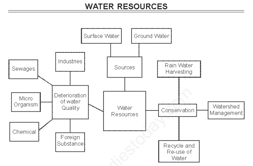
DETERIORATION OF WATER QUALITY
- Per-capita availability of water is dwindling day by day
- Increasing population
- Increase the standard of living
- Ground water pollution
- Urban waste and industrial waste is left in to the rivers
- Cultural activities produce more wastage in to the rivers
- Ganga and Yamuna are most polluted rivers in India
WATER CONSERVATION AND MANAGEMENT
- Adopt laws and acts to conserve water
- Use water saving methods and technology
- prevent water pollution
- Watershed development
- Rainwater harvesting
- Water recycling and reuse
Prevention of water pollution
- The central pollution control board along with state pollution control boards should monitor the pollution
- Frequent supervision is essential
- The other rivers such as Sabarmati, Gomati, Kai, Addayar, Vaigai , also to monitor for pollution
- Monitoring the industries located along the river banks
RECYCLE AND REUSE OF WATER
- Low quality of water can be used for industries
- Water from domestic centers to be used for garden
- Water used for cleaning vehicles also used for gardening
WATER SHED MANAGEMENT
- Efficient management of surface and ground water and conservation is called water shed development.
- Prevention of runoff, storage and recharge of groundwater through percolation tanks, recharge sells.
- Bring balance between natural availability and utility
- It depends on community participation
- HARYALI is the water shed development started by Central Govt.
- NERU-MEERU by AP govt. ARVARY PANI SANSAD by Government of Rajasthan.
- Construction of check dams, plantation
- Making compulsory to the public to make rainwater harvesting before constructing building done in TN
RAINWATER HARVESTING
- It is the method of capturing and storing rainwater, for various uses.
- Refilled the ground water wells
- It improves water quality
- Reduces the water pollution
- Dilution of salts takes place in the water
- Rainwater harvesting is practiced in different areas by different tribes
- Harvesting through service wells, recharge wells kund or tanka
- It increases ground water level
NATIONAL WATER POLICY
- Multipurpose projects should include drinking water
- Provide drinking water to all animals and man is first priority
- Regulation of exploitation of ground water - Both ground and surface water quality should be regularly
- Increase the efficacy use of water
- Awareness of importance of water to be imparted to the common people
- Conservation of water to be realized by the all people
CASE STUDY RALEGAN SIDDHI
- It is an example for watershed development
- A retired army personnel realized the importance of water shed and convinced the public
- Voluntary participation took place and developed the water shed
- The status of village is changed
- Dependency started declining
- Tarun mandal was formed to control pollution
- Controlled grazing started
- Dry crops were started growing
- Community leaders took the control of the village
- People developed each other
- It is the model village in India
Important Questions NCERT Class 10 Social Science Chapter 3 Water Resources
Question. On which one of the following rivers Sardar Sarovar Dam is built?
(A) River Kaveri
(B) River Krishna
(C) River Narmada
(D) River Satluj
Answer. D
Question. Which chemical has concentrated in water in Bihar?
(A) Salt
(B) Salinity
(C) Fluoride
(D) Arsenic
Answer. D
Question. Which out of the following has the highest use of groundwater?
(A) Punjab
(B) Chhattisgarh
(C) Bihar
(D) Kerala
Answer. A
Question. Haryali program is related to development of:
(A) Forest Cover
(B) Watershed Development
(C) Soil Conservation
(D) Food Grain Production
Answer. B
Question. Environment Protection Act was implemented in:
(A) 1974
(B) 1986
(C) 1988
(D) 1997
Answer. B
Question. Which group of states is highly affected by concentration of fluoride in ground water resources:
(A) Uttar Pradesh
(B) Bihar-West Bengal
(C) Rajasthan-Maharashtra
(D) Punjab-Haryana
Answer. C
Question. Which one of the following rivers has the highest replenishable groundwater resource in the country?
(A) The Indus
(B) The Brahmaputra
(C) The Ganga
(D) The Godavari
Answer. C
Question. Neeru-Meeru program belongs to which state?
(A) Gujarat
(B) Rajasthan
(C) Punjab
(D) Andhra Pradesh
Answer. D
Question. What stands for the CPCB?
(A) The Commandant Pollution Control Board
(B) The Central Pollution Control Board
(C) The Central Polythene Control Board
(D) None of these
Answer. B
Question. In which year, Government of India has launched ‘Jal Kranti Abhiyan’ ?
(A) 2011-12
(B) 2013-14
(C) 2015-16
(D) 2017-18
Answer. C
Question. Which of the following statement about water resources is NOT true?
(A) Water is a cyclic resource.
(B) Approximately 71% of the Earth's surface is covered with fresh water
(C) Approximately 97% of the total water on the earth is saline water.
(D) India accounts about 4% of the world's water resources.
Answer. B
Question. Which part of the Yamuna river is most polluted in India?
(A) Between Mathura and Etawa.
(B) Between Delhi and Mathura.
(C) Between Delhi and Etawa.
(D) Between Agra and Mathura.
Answer. C
Question. Which of the following is not correctly matched?
(A) Water (Prevention and Control of Pollution) Act- 1974
(B) Environment Protection Act . 1988
(C) The Water Cess Act- 1977
(D) None of the above
Answer. B
Question. Which one is not a key feature of India’s National Water Policy, 2002?
(A) Providing drinking water to all human beings and animals should be the first priority.
(B) Measures should be taken to limit and regulate the exploitation of groundwater.
(C) The efficiency of utilisation in all the diverse uses of water should be improved.
(D) Awareness of water as a scarce resource should not be fostered
Answer. D
Question. Water scarcity is possibility to pose the greatest challenge on account of.
(A) Increasing population.
(B) Excess use of water.
(C) Water pollution.
(D) All of the above
Answer. D
Question. Assertion (A): The states like Kerala, Orissa and West Bengal have vast surface water resources in lagoons and lakes.
Reason(R): It is used for fishing and irrigating certain varieties of paddy crops, coconut etc,,
(A) Both A and R are true and R is the correct explanation of A
(B) Both A and R are true but R is not the correct explanation of A
(C) A is true but R is false
(D) A is false but R is true
Answer. B
Question. Which of the following states made compulsory to install rainwater harvesting system while constructing houses or buildings?
(A) Tamil Nadu
(B) Karnataka
(C) Kerala
(D) Andhra Pradesh
Answer. A
Question. What factors are responsible for the highest groundwater development in the states of Punjab, Haryana, and Tamil Nadu?
Answer. Groundwater development in the states of Punjab, Haryana, and Tamil Nadu has been intense due to irrigated agriculture because:
• The development of irrigation to increase agricultural production and these were the target regions for green revolution.
• Spatio-temporal variability in rainfall makes irrigation a necessary alternative for agriculture in the country.
• Provision of irrigation makes multiple cropping possible.
Question. What is watershed management? Do you think it can play an important role in sustainable development?
Answer. Watershed management basically refers to efficient management and conservation of surface and groundwater resources with community participation. It involves prevention of runoff and storage and recharge of groundwater through various methods like percolation tanks, recharge wells, etc. Watershed management aims at bringing about balance between natural resources on the one hand and society on the other. The success of watershed development largely depends upon community participation. The Project is being executed by Gram Panchayats with people’s participation:
• Haryali is a watershed development project sponsored by the Central Government which aims at enabling the rural population to conserve water for drinking, irrigation, fisheries and afforestation. The Central and State Governments have initiated many watershed development and management programmes in the country:
• Neeru-Meeru (Water and You) programme (in Andhra Pradesh) and Arvary Pani Sansad (in Alwar, Rajasthan) have taken up constructions of various water-harvesting structures such as percolation tanks, dug out ponds (Johad), check dams, etc., through people’s participation.
Question. Study the diagram given below and answer the questions that follows.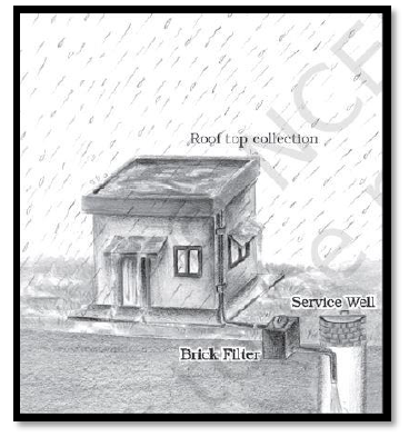
i) Give an appropriate title to the given diagram.
Answer. Rain water harvesting through Roof top collection
ii) How is rainwater harvested through this technique?
Ans. Rainwater harvesting from roof tops use artificially created catchment, which are drained into a service well which recharges ground water.
Question. Write down major objectives of rainwater harvesting and mention some low cost rainwater harvesting techniques.
Answer. Objectives
- Meet ever increasing demand
- Reduce run off which chokes drains.
- Avoid flooding of roads
- Augment of groundwater storage and raise the water table.
- Reduce groundwater pollution
- Improve quality of groundwater
- Reduce soil erosion
- Supplement domestic water requirement during summer and drought.
Low cost rainwater harvesting techniques
- Roof water harvesting
- Refilling of dug-wells
- Recharge of hand pumps
- Construction of percolation pits and trenches.
Question. “Water harvesting system is an effective measure to reduce the problem of water scarcity.” Justify the statement.
Answer. Water is an essential item for human existence but it is also one of the mostmisused commodities. Through the passage of time, early societies understood the importance and need for water and planned their lives around it. Civilizations have been born and lost on account of water. Today, we have the advantage of this knowledge.
Rain is the primary source of water, but we get rain only during the monsoon season in India during the months of July, August and September. Even in these three months it has been found that most areas get about 80% of the annual rain in about just 24 days.
A large amount of this precious water just drains away. The only way to save this water from wastage is by rain water harvesting. In its simplest form it involves storing the rain water in tanks, or by making embankments etc. The different methods of rain water harvesting used in India have been as follows:
(a) Guls or Kuls in the Western Himalayas
(b) Rooftop rain water harvesting in Rajasthan associated with tankas .Khadins in Jaisalmer and Johads in other parts of Rajasthan were also popular.
(c) Inundation channels in West Bengal
(d) In Meghalaya which gets copious rain, rain water harvesting is commonly practiced.
(e) In modern civil construction and housing societies provision for rain water harvesting
Question. How have Industrialization and urbanization posed a great pressure on existing fresh water resources in India? Explain with examples.
Answer. Post independence India witnessed intensive industrialisation and urbanisation.
(i) Arrival of MNC's : Apart from fresh water they required electricity which comes from hydroelectric power.
(ii) Multiplying urban centers with large and dense population and urban life styles have only added to water and energy requirements, which has further aggravated the problem.
(iii) Large-scale migration from rural to urban areas is causing over exploitation of water resources.
Question. Describe any three traditional methods of rainwater harvesting adopted in different parts of India.
Answer. (i) In hilly and mountainous regions, people build diversion channels like 'gul' or 'kul' in eastern Himalaya for agriculture.
(ii) Roof-top rainwater harvesting was commonly practised to store drinking water particularly in Rajasthan.
(iii) In semi-arid regions agricultural fields are converted into rainfed storage structures that allow the water to stand and moist the soil.
Question. Describe the procedure for roof top rainwater harvesting.
Answer. (i) Rooftop rainwater is collected using a PVC pipe.
(ii) Collected water is filtered using sand and bricks.
(iii) Underground pipe is used to take the water to the tank for immediate usage.
(iv) Excess water from the tank is taken to the well.
(v) Water from the well recharges the underground water.
Question. Why are different water harvesting systems considered a viable alternative both socioeconomically and environmentally in a country like India?
Answer. Keeping into view the disadvantages and rising resistance against the multi-purpose projects, water harvesting system is considered a viable alternative both socio-economically and environmentally.
(i) In ancient India also along with the sophisticated hydraulic structures, there existed and extra-ordinary tradition of various water harvesting systems.
(ii) People adopted different techniques in different areas. In hilly regions people build diversion channels like the 'guls' or 'Kuls' for agriculture.
(iii) Roof-top rain water harvesting was commonly practised to store drinking water, particularly in Rajasthan.
(iv) In the flood plains of Bengal, people developed inundation channels to irrigate their fields. Khadins, Johads and Tanks are the forms of rain water harvesting practised in Rajasthan.
Question. Explain the working of underground tanks as a part of rooftop rainwater harvesting system practised in Rajasthan.
Answer. (i) In semi-arid and arid regions of Rajasthan almost all the houses traditionally had underground tanks for storing drinking water. They are extremely reliable source of drinking water when other sources dry up. Rain water is considered the purest form of natural water.
(ii) The tanks can be as large as big rooms.
(iii) The tanks were part of the well-developed roof-top rainwater harvesting systems.
(iv) The tanks were built inside the main house or the courtyard giving cooling effect to the rooms in the summer.
(v) Those tanks were connected to the sloping roofs of the houses by a pipe.
(vi) Rain falling on these rooftops would travel down the pipe and get stored in these underground tanks.
(vii) Usually first rain water is not collected as it cleans the rooftop and get the pipe.
Question Q1. Which percentage of earth is covered with water?
Answer: 71%.
In simple words: Approximately 71 percent of the earth's surface is covered with water.
Exam Tip: Remember this basic geographical fact as it is often asked in 1-mark objective questions.
Question Q2. Mention any two States where ground water level utilization is very high.
Answer: Punjab and Haryana.
In simple words: Punjab and Haryana use a very high percentage of their available groundwater resources mainly due to intensive agriculture.
Exam Tip: High agricultural intensity leads to heavy reliance on tubewells for irrigation in these states.
Question Q3. Which sector grounds for most of the surface and ground water utilization?
Answer: Agriculture.
In simple words: The agricultural sector consumes the maximum amount of both surface water and groundwater in India.
Question Q4. Why is irrigation required? Give one reason?
Answer: Because of spatiotemporal variability in rainfall in the country.
In simple words: Rainfall in India is unevenly distributed across different places and times, making artificial watering necessary for crops.
Exam Tip: Spatiotemporal variability means variation across space (location) and time (seasons/years).
Question Q5. In which state major part of irrigation is carried out by well, tube-wells?
Answer: Gujrat.
In simple words: Gujarat relies heavily on wells and tubewells for watering its agricultural fields.
Exam Tip: Note the spelling as given in standard board marking schemes (Gujrat/Gujarat).
Question Q6. Mention two highly polluted rivers of our country.
Answer: Ganga and Yamuna.
In simple words: Ganga and Yamuna are among the most polluted rivers in India due to industrial waste and urban sewage.
Exam Tip: Mentioning major metropolitan river basins highlights urban discharge impacts.
Question Q7. What is the local name of rainwater harvesting structure in Rajasthan?
Answer: Kund or Tanka.
In simple words: In Rajasthan, traditional underground tanks used to store harvested rainwater are called kunds or tankas.
Exam Tip: Traditional water harvesting terms are important for regional geography questions.
Question Q8. Who has Sponcered Hariyali programme?
Answer: Central Govt. of India.
In simple words: The Hariyali watershed development program is sponsored by the Central Government of India.
Exam Tip: Associate Hariyali directly with central watershed management initiatives.
Question Q9. In which state Aravary pani sansad has been launched?
Answer: Rajasthan.
In simple words: The 'Aravari Pani Sansad' initiative for water management was launched in Rajasthan.
Exam Tip: Connect local water parliaments with community-based conservation in arid regions.
Question Q10. Give three reasons of depleting quality of water and scarcity of water?
Answer:
(i) Increasing demand of water
(ii) Excessive use of water
(iii) Water pollution.
In simple words: Rapid population growth, over-extraction, and discharge of pollutants reduce usable water supplies.
Exam Tip: List points clearly using Roman numerals as presented in board keys.
Question Q11. Describe the use of water in various sectors -
Answer:
(i) Agriculture - Utilized primarily for crop irrigation and livestock.
(ii) Multipurpose projects - Used for hydroelectric power generation, flood control, and irrigation.
(iii) Industrial sector - Used for cooling, processing, and manufacturing operations.
In simple words: Water is vital for farming, large river valley projects, and factory production.
Exam Tip: Categorize sectors clearly to score full marks in descriptive answers.
Question Q12. Why is irrigation necessary in India?
Answer: Because of the following reasons -
(i) Seasonal rainfall
(ii) Uncertainty of rainfall
(iii) Uneven distribution of rainfall
(iv) Growing more and more food crops
(v) Dry climate in some region
(vi) Cash crops.
In simple words: India's monsoon is seasonal, uncertain, and uneven, requiring artificial irrigation to support intensive farming and cash crops.
Exam Tip: Memorize at least four clear points regarding monsoon variability for 3-mark questions.
Question Q13. What are the main features of "National Water policy of India 2002"? Explain
Answer:
(i) Make available drinking water to every one.
(ii) To check the exploitation of ground water.
(iii) Start programme to check and improve the quality of water.
(iv) To create awareness among people about water in the form of "Rarely available resource".
(v) Scientific use of water.
(vi) Increasing conservation awareness by educational institutions and other enterprises.
In simple words: The 2002 policy prioritizes drinking water, regulates groundwater extraction, improves water quality, and promotes conservation awareness.
Exam Tip: Highlight key policy priorities like drinking water allocation priority.
Question Q14. What factors are responsible for maximum water development in Punjab Haryana and Tamil Nadu?
Answer:
(i) Perennial rivers
(ii) Capacity of easy seepage of water in the soil
(iii) More capacity of ground water resources.
In simple words: Availability of perennial rivers, favorable soil seepage, and rich groundwater potential promote water resource development in these states.
Exam Tip: Link terrain and hydrogeological factors to high irrigation development.
Question Q15. What is rain water harvesting? Explain the objectives of rain water harvesting.
Answer: Rain water harvesting is a technique of collecting rain water and also increasing water level in the ground.
Objectives -
(i) Meeting with the increasing demand of water.
(ii) Checking floods.
(iii) To meet out with the domestic demand during dry spell in summer.
In simple words: Rainwater harvesting captures precipitation for storage and groundwater recharge to combat water scarcity.
Exam Tip: Clearly separate definition from objectives when answering 3-mark questions.
Question Q16. Why is Conservation of water necessary in India? Give three reasons.
Answer:
(i) Completing the demand of water of increasing population.
(ii) Due to intensive agriculture
(iii) Due to industrialization.
In simple words: Population growth, intensive farming, and industrial expansion require urgent water conservation to prevent severe shortages.
Exam Tip: Focus on demographic and economic pressure points.
Question Q17. Discuss the availability of water resource in the country and factor that determine its spatial distribution.
Answer:
The spatial distribution are:
(1) Surface water resource - The mean annual flow in all the river basins in India is estimated to be 1869 cubic km. There are four major sources of surface water. These are rivers, lakes, ponds and tanks. Only about 690 cubic km (32%) of the available surface water can be utilised.
(2) Ground Water Resource - The total ground water resources in the country are about 432 cubic km. The Ganga and the Brahamaputra basins have about 46% of the total ground water resources.
(3) Lagoons & Backwaters - There are several Lagoon lakes at the coastline of India. Such Lakes are largely found in Kerala, Orissa & West Bengal. The water is generally brackish.
Factors:
(1) Uneven distribution of rainfall
(2) Difference in relief
(3) Difference in soil types
(4) Difference in natural vegetation
(5) Drainage system
(6) Sea coast
(7) Rock structure. etc.
In simple words: India has vast surface and groundwater resources, but their availability varies greatly across regions due to geographical and climatic factors.
Exam Tip: For 5-mark answers, ensure both availability statistics and determining factors are well elaborated.
Question Q18. Discuss the factors responsible for depletion of water resources?
Answer:
(1) Decreasing water-table
(2) Wastage of water
(3) Water Pollution
(4) Improper water Management
(5) Deforestation
(6) Population Explosion.
In simple words: Overuse, pollution, population growth, and poor management lead to severe depletion of water resources.
Exam Tip: Use bulleted points and explain key environmental factors concisely.
Question Q19. What is watershed Management? Do you think it can play an important role in sustainable development?
Answer: It refers to efficient management and Conservation of surface and ground water resources. It involves prevention of run off and storage and recharge of ground water. Yes, it plays an important role in sustainable development by the following Methods:
(1) Water Shed development
(2) Rain Water Harvesting
(3) Re-cycling of water
(4) Conjunctive use of water
(5) Saving water in household works
(6) Prevention of water pollution
(7) Re-use of water
(8) People awareness about water conservation.
In simple words: Watershed management conserves soil and water resources to meet current needs without compromising future availability.
Exam Tip: Emphasize runoff prevention and groundwater recharge as core components of watershed management.
Question Q20. Study the map and answer the following questions: River Basin and towns located on them.
1. Which river and its tributaries are shown in the map?
Answer: River Ganga and its tributaries.
2. Name any three towns located on the bank of the main river.
Answer: Kanpur, Varanasi, Allahabad, Patna.
3. In which part of the river is the quality of water good and why?
Answer: In the mountainous region and foothill. Due to addition of fresh water from glaciers and lack of industries and human interference.
4. How does the quality of water gets deteriorated in the Central and Eastern part of the river?
Answer: Because of the pollution created by industries and human population.
In simple words: The Ganga river is clean in upper mountainous regions but gets heavily polluted downstream due to urban and industrial waste.
Exam Tip: Map-based questions require precise identification of river stretches and urban centers.
Question Q21. Study the given table and answer the questions that follow:
Percentage of net irrigated area to total area by
| State | Percentage |
|---|---|
| Gujarat | 86.6 |
| Rajasthan | 77.2 |
| Madhya Pradesh | 66.5 |
| Maharashtra | 65.0 |
| Uttar Pradesh | 58.2 |
| West Bengal | 57.6 |
| Tamil Nadu | 54.7 |
1. Which state shows the highest percentage of net irrigated area of wells and tubewells?
Answer: Percentage of net irrigated area to total area by wells and tubewells is the highest in Gujarat (86.6%).
2. What are the implications of using ground water in drought prone areas of Rajasthan, Gujarat, Maharashtra and Tamilnadu?
Answer:
(i) The overuse of groundwater resources has led to decline in groundwater table in these states.
(ii) Over withdrawal has increased fluoride concentration in groundwater.
(iii) This practice in these states has led to increase in concentration of arsenic in parts of Maharashtra and Tamilnadu.
In simple words: Over-reliance on groundwater in arid states lowers water tables and contaminates water with harmful minerals like fluoride and arsenic.
Exam Tip: Note specific chemical contaminations (fluoride and arsenic) resulting from groundwater over-extraction.
Question Q22. How has Ralegan Siddhi become an example for watershed development throughout the country?
Answer:
1. Retired army personnel settled down in the village and took up the task of watershed development.
2. Those who were working outside the village contributed to the development by committing a month's salary every year.
3. Percolation tanks were constructed in the village.
In simple words: Community mobilization, local leadership, and voluntary contributions transformed Ralegan Siddhi into a model village for water conservation.
Exam Tip: Mention community participation and leadership as key drivers of Ralegan Siddhi's success.
Question Q23. Why is irrigation more developed in the great plains than in peninsular India?
Answer:
1. These plains have low lying relief.
2. In this region, agriculture is the main occupation.
3. Water resources are abundant due to perennial rivers.
4. The slope of the land is so gentle that canal irrigation is convenient.
5. Digging of canals and wells is easy due to nature of terrain and soil.
6. Underground water is abundantly available.
In simple words: Flat terrain, perennial rivers, fertile soil, and soft ground make irrigation much easier in the Northern Plains than in Peninsular India.
Exam Tip: Contrast topographical and hydrological conditions between northern plains and peninsular plateau.
Question Q24. Why is the petroleum referred to as "Liquid Gold"?
Answer: Crude petroleum consists of hydrocarbons of liquid and gaseous states varying in chemical composition, colour and specific gravity.
- Essential sources of energy for all internal combustion engines in automobiles, railways and aircrafts.
- Because of its scarcity and diversified uses.
In simple words: Petroleum is called liquid gold because it is a scarce, highly valuable energy source powering global transport and industry.
Exam Tip: Highlight both economic value and versatile applications in transport and industry.
Free study material for Geography
Download Practice Assignments: Class 12 Geography India People And Economy Chapter 04 Water Resources
Chapter Practice Questions for Class 12 Geography
Access structured practice assignments for India People And Economy Chapter 04 Water Resources designed in alignment with the latest CBSE curriculum for Class 12 Geography. These printable sets cover objective and descriptive problem types to support thorough revision.
Key Advantages of Solving India People And Economy Chapter 04 Water Resources Assignments
- Exam Alignment: Questions strictly follow contemporary CBSE sample papers and grading schemes.
- Comprehensive Coverage: Features objective drills, case studies, and structured descriptive problems for India People And Economy Chapter 04 Water Resources.
- Pacing & Precision: Regular problem-solving builds critical calculation speed and test-taking accuracy.
How to Approach Geography India People And Economy Chapter 04 Water Resources Assignments
- Initial Reading: Begin by reading the NCERT book for Class 12 Geography to build a baseline understanding.
- Independent Testing: Attempt assignment questions unassisted, then verify work using provided answer keys.
- Supplementary Aids: Leverage revision notes and worksheets whenever you encounter difficult topics.
FAQs
You can download free PDF assignments for Class 12 Geography India People And Economy Chapter 04 Water Resources from StudiesToday.com. These practice sheets have been updated for the 2026-27 session covering all concepts from latest NCERT textbook.
Yes, our teachers have given solutions for all questions in the Class 12 Geography India People And Economy Chapter 04 Water Resources assignments. This will help you to understand step-by-step methodology to get full marks in school tests and exams.
Yes. These assignments are designed as per the latest CBSE syllabus for 2026. We have included huge variety of question formats such as MCQs, Case-study based questions and important diagram-based problems found in India People And Economy Chapter 04 Water Resources.
Practicing topicw wise assignments will help Class 12 students understand every sub-topic of India People And Economy Chapter 04 Water Resources. Daily practice will improve speed, accuracy and answering competency-based questions.
Yes, all printable assignments for Class 12 Geography India People And Economy Chapter 04 Water Resources are available for free download in mobile-friendly PDF format.