DEPARTMENT OF SOCIAL SCIENCE
CLASS: IX: GEOGRAPHY
CHAPTER: 1: INDIA: Size and Location
Question
Summary of the lesson:
• India spreads across both the Eastern and the Northern Hemispheres.
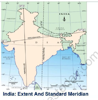
• India’s latitudinal stretch is between 8°4’N and 37°6’N, and the longitudinal stretch is between 68°7’E and 97°25’E
• The Tropic of Cancer is at 23˚30’N latitude cuts across the country, dividing it almost into two equal halves.
• The country has the Andaman and Nicobar Islands in the south-east and the Lakshadweep Islands in the southwest.
• The total area of the Indian land mass is 3.28 million square kilometres i.e. nearly 2.4% of the total land area of the world. India is the seventh largest country in the world.
• India is bordered by the young fold mountains on the north-western, northern and north-eastern side, the Bay of Bengal in the east, the Arabian Sea in the west and the Indian Ocean in the south.
• India’s total coastline, including the Andaman and Nicobar Islands, and the Lakshadweep Islands measures: 7,516.6 kilometres
• India’s east-west stretch and north south stretch each measure approximately 3000 kilometres and causes a time lag of 2 hours between the local times at the eastern and the western ends. India’s standard time is the time along longitude 82.30 degrees East. This longitude passes through Mirzapur in Uttar Pradesh and is referred to as the Standard Meridian of India.
• While India’s longitudinal stretch gives rise to a time lag between the east and the west, its latitudinal stretch influences the duration of days and nights.
a) Give the latitudinal and longitudinal extent of India.
OR
Mention the Latitudinal Extent of India? Mention its significance OR implications.
Ans.: Latitudinal extent: 8˚4’N and 37˚6’N.
Longitudinal extent: 68˚7’E and 97˚25’E.
Latitudinal and longitudinal extent of India
b) What is a Sub-continent? Give an example of a Sub-continent. Name the countries of this Sub-continent. (Sample Q. Paper)
c) How many states and Union Territories does India have? Name the largest and smallest state of India in terms of area.
2. a) Name the southern most point of the Indian Union and state why it is submerged?
Ans.: 1.Indira Point.
2. It is submerged under the sea water since 2004 due to the Tsunami
b) Name the southern most tip of the main land of India.
Ans: Kanyakumari, Tamil Nadu, 8˚4’N.
3. Give the total length of the land boundary and the coastal line of India.
Ans.: 1The Land boundary—15,200 km.
2. The Coast line- 7,516.6 km.
4. Why the time along the Standard Meridian of India passing through Mirzapur is taken as the standard time for the whole country?
Or
Why is 82˚30‟E selected as the Standard Meridian of India?
Ans.
1. According to an International convention, the Standard Meridian of a country is selected in multiples of 7½˚ or 15 ˚.
2. 82˚30’E is a multiple of 7½˚. Hence it is internationally accepted.
3. Since there is a time lag of two hours between Gujarat and Arunachal Pradesh and 82˚30’E passes through Mirzapur, in Uttar Pradesh, which is a prominent place. It gives common time for the whole country.
4. Give the Diagram. (to be drawn on the board)
5. Name the countries which are larger than India.
Ans.: Russia, Canada, USA, China, Brazil and Australia.
6. Which Island countries are our southern neighbours?
Ans.: 1. Maldives 2. SriLanka.
7. Name the Straits that separate Sri Lanka from India.
Ans.: The Palk Strait and The Gulf of Mannar.
8. Name the states that share common frontiers with Nepal.
Ans.: Uttaranchal, Uttar Pradesh, Bihar, West Bengal, and Sikkim.
9. „The Central location of India at the head of the Indian ocean is considered of great significance‟ Why?
Ans.:
1. The Indian landmass has a central location between the East and West Asia.
2. The Trans Indian Ocean routes, which connect the countries of Europe in the west and the countries of East Asia, provide a strategic central location to India.
3. The Deccan Peninsula protrudes into the Indian Ocean, thus helping India to establish close contact with the West Asia, Africa, and Europe from the western coast and with southeast and East Asia from the eastern coast.
10. Give a brief account of India‟s contacts with the outside world in ancient and medieval times.
OR
Describe India‟s contact with the world through ages.
Ans.:
1. These contacts have contributed in the exchange of ideas and commodities since ancient times.
2. The ideas of the Upanishads and the Ramayana, the stories of Panchatantra thus could reach many parts of the world
3. The spices, muslin and other merchandise were taken from India to different countries.
4. On the other hand, the influence of Greek sculpture and the architectural styles of dome and minarets from West Asia can be seen in different parts of our country.
11. Name the States in all the four extreme directions.
OR
Which is the western most state of India?
Ans.:
Jammu and Kashmir (North), Tamil Nadu(South) Gujarat(West) Arunachal Pradesh (East)
12. What is the total area of India? What percentage does it constitute of the world‟s total area?
Ans.: 1. Total area—3.28 million sq. km. 2. It has only 2.42% of the world’s total land area.
13. How was the land route favourable to India in the past?
Ans.:
1. India’s contacts with the world had continued for ages, but her relationships through the land routes are much older than her maritime contacts.
2. The various passes across the mountains in the north have provided passage to the orient travellers while the oceans restricted such interactions for a long time.
14. Why the difference between the duration of day and night is felt more in Kashmir than in Kanyakumari?
Ans.:
1. Kanyakumari: It receives vertical rays of the sun which give more heat. It is situated near the equator (0˚) therefore the difference between day and night is of 45 minutes.
2. Jammu and Kashmir: It is located far away from the equator. It receives oblique rays. Therefore there is some difference between the duration of day and night (5 hours).
Please click on below link to download CBSE Class 9 Social Science India Size and Location Worksheet Set A