SENIOR SECTION
DEPARTMENT OF SOCIAL SCIENCE
CLASS: IX - GEOGRAPHY
CHAPTER:3 : DRAINAGE.
Question
1 Define the terms: Drainage, Drainage Basin, Water Divide
Drainage: describes the river system of an area.
Drainage Basin: The area drained by a single river system
Water Divide: Any elevated area, such as a mountain or upland, separates two drainage basins.
2 Differentiate between Himalayan rivers and Peninsular rivers.
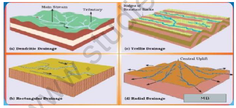
3 Describe the following drainage patterns with suitable diagrams:
a) Dendritic b) Trellis c) Rectangular d) Radial
a) Dendritic: develops where the river channel follows the slope of the terrain.
The stream with its tributaries, resembles the branches of a tree
b) Trellis: A river joined by its tributaries , at app. right angles
c) Rectangular: develops on a strongly jointed rock y terrain
d) Radial: develops when streams flow in different directions from a central peak and dome-like structure.
5 Describe the Indus river system under the following headings:
a) Origin :
b) Tributaries joining in the Kashmir region :
c) Mouth of the river :
d) Tributaries of the main river :
e) Slope:
f) Length :
g) States of India in which 1/3rd basin is located:
6 Describe the Ganga river system under the following headings:
a) Headwaters of the Ganga : called the Bhagirathi is fed by the Gangotri glacier and joined by the Alaknanda at Devaprayag in Uttaranchal.
b) Place where Ganga emerges from the mountains on to the plains - Haridwar
c) Tributaries joining the river from the Himalayas : Yamuna, Ghaghara, Gandak and Kosi
d) Origin of river Yamuna and where it meets River Ganga : Rises in the Yamunotri glacier and meets the Ganga at Allahabad.
e) Tributaries rising in Nepal Himalaya : Ghaghara, Gandak and Kosi
f) Two implications of rivers rising from Nepal : i) they flood parts of the northern plains every year causing widespread damage to life and property.
ii) enrich the soil for the extensive agricultural lands.
g) Main tributaries from the peninsular uplands : Chambal, Betwa and Son
h) Characteristics of these tributaries : They rise from the semi-arid areas, have shorter courses and do not carry much water in them.
i) Northernmost point of Ganga delta : Farakka in West Bengal
j) Name of a Distributary that flows through the deltaic plains : Bhagirathi-Hooghly
k) Mouth of the river Ganga and name of its delta. :Bay of Bengal;
Sunderban
i) Two characteristics of Sunderban delta : i) It is the world’s largest and fastest growing delta ii) It is also the home of the Royal Bengal Tiger
j) Length of the river: 2500 km.
k) Slope of the river: The plains form Ambala to the Sunderban stretch over nearly 1800km.,but the fall in slope is hardly 300 mt.There is a fall of just 1mt. for every 6 km.
l) Place of water divide between Indus and Ganga river systems : Ambala
m) Feature formed by the river : Large meanders
7 Describe the Brahmaputra river system under the following headings:
a) Origin : rises in Tibet east of Mansarowar lake
b) Length : slightly longer than Indus
c) How and where does it enter into India? : On reaching the Namcha
Barwa,it takes a ‘U’-turn and enters India in Arunachal Pradesh through a gorge.
d) Name of the river in Arunachal Pradesh: Dihang
e) Names of its tributaries in Assam : Dibang, Lohit, Kenula
f) Name of Brahmaputra in Tibet and Bangladesh : Tsang Po in Tibet and Jamuna in Bangladesh
g) Brief note on braided channel : It has a braided channel in its entire length in Assam and forms many riverine islands.
h) Reasons for floods in Assam and Bangladesh :
i)Every year during the rainy season, the river overflows its banks, causing widespread devastation due to floods in Assam and Bangladesh.
ii) Unlike other north-Indian rivers, the Brahmaputra is marked by huge deposits of silt on its bed causing the river bed to rise.
iii) The river also shifts its channel frequently.
8 “Inspite of a long upper course, the river Brahmaputra carries less amount of silt when it enters in to India”.Why?.Give2 reasons.
i) it carries a smaller amount of water as no tributaries join it in its upper course
ii) It flows through a cold and dry area in its upper course.
THE PENINSULAR RIVERS
9 Distinguish between: West flowing and East flowing rivers.
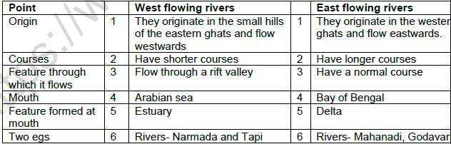
10 Explain the River Narmada with reference to the following:
a) Origin : rises in the Amarkantak hills
b) Feature in to which it flows : flows towards the west in rift valley formed due to faulting
c) Direction of Flow : Flows towards the west
d) Any two picturesque locations created : i) The ‘ Marble rocks’, near Jabalpur where the Narmada flows through a deep gorge ii) the ‘Dhuadhar falls’, where the river plunges over steep rocks
e) Type of drainage pattern : Trellis
f) States covered by basin : Madhya Pradesh and Gujarat
g) Feature at mouth : Estuary
11 Explain the River Tapi with reference to the following:
a) Origin : rises in the Satpura ranges, in the Betul district of Madhya Pradesh.
b) Direction of Flow and feature through which it flows : Flows in a rift valley, parallel to the Narmada
c) Length : shorter in length
d) States covered by basin : M.P., Gujarat and Maharashtra
e) Feature at mouth : Estuary
f) Feature through which it flows :rift valley
12 Explain the River Godavari with reference to the following:
a) Origin : rises from the slopes of the western ghats in Nasik district of Maharashtra.
b) Direction of Flow : Flows eastwards and drains into the Bay of Bengal.
c) Length : 1500km.
d) Feature at mouth : Delta
e) States drained : Maharashtra, M.P., Orissa, Andhra Pradesh
f) Other name of the river : Dakshin Ganga
13 Explain the River Mahanadi with reference to the following:
a) Origin : rises in the highlands of Chhattisgarh
b) Direction of Flow : flows through Orissa to reach Bay of Bengal
c) Length : 860 km
d) Feature at mouth : Delta
e) States drained : Maharashtra, Chhattisgarh,Jharkand,Orissa
14 Explain the River Krishna with reference to the following:
a) Origin : Rises from a spring near Mahabaleshwar
b) Direction of Flow : flows westwards reaching the Bay of Bengal
c) Length : 1400 km
d) Feature at mouth : Delta
e) States drained : Maharashtra, Karnataka and Andhra Pradesh
f) Tributaries : Tungabhadra, Musi, Ghatprabha, Bhima
15 Explain the River Kaveri with reference to the following:
a) Origin : rises in the Brahmagiri range of the western ghats
b) Direction of Flow : Reaches the Bay of Bengal south of Cuddalore,Tamil Nadu
c) Length : 760 km
d) Feature at mouth : Delta
e) States drained : Karnataka, Kerala, Tamil Nadu
f) Tributaries : Amravati,Bhavani,Hemavati,Kabini
16 What is a lake?Which are the various physical factors that bring about differences in the formation of lakes?
1. A body of water that lies in a hollow in the earth’s surface and is entirely surrounded by land.
2. Lakes in the semi-arid regions in the basins of inland drainage contain water only during the rainy season.
3. Some of the lakes are the result of the action of glaciers and ice-sheets
4. Other lakes have been formed by wind, river action and human activities.
17 How are lakes formed by :
a) a meandering river : A meandering river across a flood plain forms cut-offs that later develop into ox-bow lakes.
b) in the coastal areas: Spits and bars form lagoons in the coastal areas.
18 Where are most of the fresh water lakes found in India? What is their origin? How are these lakes formed?
1.Most of the fresh water lakes are in the Himalayan region and are of glacial origin.
2.They formed when glaciers dug out a basin, which was later filled with snowmelt.
19 Which is the largest fresh water lake in India? How was it formed?
1.Largest freshwater lake is Wular lake
2.Formed due tectonic activity.
20 Give the importance of lakes.
• Controls flooding
• Regulate flow of water
• Helps in moderating climate
• Maintain the aquatic ecosystem
Please click on below link to download CBSE Class 9 Social Science Drainage Worksheet Set C