DEPARTMENT OF SOCIAL SCIENCE
CLASS: IX GEOGRAPHY
CHAPTER: 2 – PHYSICAL FEATURES
Summary:-
Tectonic Plate Theory:- This theory is based on continental drift which explains the formation of various continents over millions of years; as we see them today.
Plate Boundaries:-Convergent Boundary, Divergent Boundary and Transform Boundary MAJOR PHYSIOGRAPHIC DIVISIONS:The landmass of India can be divided into following major physiographic divisions:
a.The Himalayan Mountains
b.The Northern Plains
c.The Peninsular Plateau
d. The Indian Desert
e. The Coastal Plains
f.The Islands
Physical Features of India
The Himalayan Mountain. The Himalayas run along the northern border of India. The Himalayas form an arc which is about 2,400 km long.
Himalayan Regions from East to West:
a)Punjab Himalayas:- This part lies between the Indus and Sutlej.
b)Kumaon Himalayas: This part lies between Sutlej and Kali rivers.
c)Nepal Himalayas: This part lies between the Kali and Tista rivers.
d)Assam Himalayas: This part lies between the Tista and Dihang rivers. The Northern Plain :The northern plain of India is formed by three river systems, viz. the Indus, the Ganga and the Brahmaputra; along with their tributaries. This plain is composed of
alluvial soil which has been deposited over millions of years. a)Bhabar b)Terai c)Bhangar: d)Khadar:
The peninsular plateau is a tableland. It is composed of the oldest rocks because it was formed from the drifted part of the Gondwana land.
The Western and the Eastern Ghats:- They make the western and eastern edges of the Deccan Plateau. The average elevation of Western Ghats is 900 – 1600 metres; compared to 600 metres in case of Eastern Ghats. The Eastern Ghats stretch from Mahanadi Valley to the Nilgiris in the south. The Western Ghats cause orographic rains as they face the rain-laden winds from west.
The Indian Desert:-The Indian desert lies towards the western margins of the Aravali Hills.
This region gets scanty rainfall which is less than 150 mm in a year The Coastal It is divided into three sections. The Konkan; which comprises of Mumbai and Goa makes the northern part. The Kannada Plain makes the central pat and the Malabar coast makes the Malabara coast.The western coastal plain is wider and level and it runs along the
Bay of Bengal. It is divided into two parts. The northern part is called Northern Circar. The southern part is called the Coromandel Coast. The IslandsThe Lakshadweep Islands and The Andaman and Nicobar Islands
Question
1 What are Lithospheric plates? Name the seven major Tectonic plates.
2. What does the movement of the plates result in?
3. Classify the plate movements into three types and explain each briefly with suitable diagrams.
4. Explain the formation of the Himalayas and the mountain system ofWestern Asia.
5. Describe the formation of the Northern plains of India.
6. ‘The land of India displays great physical variation.’ Explain the above statement with examples.
7. Name the major physiographic divisions of India.
8.Explain the Himalayan mountains under the following headings:i) Extent of the range ii) Shape iii) Length iv) Width v) Altitudinal variations.
Ans i) Extent of the range: These mountain ranges run in a west-east direction from the Indus to the Brahmaputra.ii) Shape : form an arciii) Length:2,400 Km.iv) Width: Their width varies from 400 Km in Kashmir to 150 Km in Arunachal Pradesh.v) Altitudinal variations: The altitudinal variations are greater in the eastern half than those in the western half.
9. Name the three parallel ranges of the Himalayas.
10.Explain Himadri range under the following headings:
Ans 1) Other name : the Great or Inner Himalayas 2) Location : The northern most range 3) Average altitude: an average height of 6,000 metres. 4) Prominent peaks : Mt. Everest Nepal 8848 ,Kanchenjunga India 8598,Makalu Nepal 8481,Dhaulagiri Nepal 8172 5) Folds: asymmetrical in nature. 6) Core of this part: composed of granite.
11. Explain the characteristics of the Himachal under the following headings:
i) Location : lies to the south of the Himadri ii) Other name : Himachal or lesser Himalaya. iii) Rocks: compressed and altered rocks. iv) Altitude: between 3,700 and 4,500 metres v) Average width: width is of 50 Km. vi) Important ranges : Pir Panjal ,Dhaula Dhar &Mahabharat vii) Famous valleys: the Kashmir ,Kangra &Kullu valley viii) Hill Stations: Mussoori ,Nainital & Ranikhet.
12. Explain the Outer Himalayas under the following: a) Other name b) Location c) Average width iv) Altitude v) Sediments
13. What are Duns? Give examples.
14. Explain the divisions of the Himalayas on the basis of regions from west to east. How have these regions been demarcated?
15. What marks the eastern-most boundary of the Himalayas?
16. What are Purvanchals? Name the hills comprising it.
17. Name the three river systems that have led to the formation of the northern plains.
18. Explain the characteristic features of Northern Plains on the basis of the following:1) Formation 2) Area covered 3) Extension 4) Width 5) Other characteristic features
19. What are the characteristics of the rivers in its lower course?
20. What do you mean by distributaries?
21. What is Doab?
22. Describe the three sections into which the northern plains have been divided.
23. Explain the divisions of the northern plains according to the variations in the relief features.
24. Distinguish between Bhangar and Khadar plains on the basis of the following:
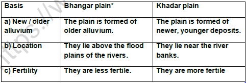
* The soil in the Bhangar region contains calcareous deposits locally known as kankar.
25. Explain the characteristics of the Peninsular plateau under the following:
1) Shape 2) Rocks 3) Formation 4) Topographic features 5) Slope 6) Main divisions.
26. What are Central Highlands?
Please click on below link to download CBSE Class 9 Social Science Physical Features Worksheet Set A

