
Read and download free pdf of CBSE Class 12 Geography Planning And Sustainable Development In India Worksheet. Students and teachers of Class 12 Geography can get free printable Worksheets for Class 12 Geography Chapter 9 Planning and Sustainable Development in Indian Context in PDF format prepared as per the latest syllabus and examination pattern in your schools. Class 12 students should practice questions and answers given here for Geography in Class 12 which will help them to improve your knowledge of all important chapters and its topics. Students should also download free pdf of Class 12 Geography Worksheets prepared by teachers as per the latest Geography books and syllabus issued this academic year and solve important problems with solutions on daily basis to get more score in school exams and tests
Worksheet for Class 12 Geography Chapter 9 Planning and Sustainable Development in Indian Context
Class 12 Geography students should download to the following Chapter 9 Planning and Sustainable Development in Indian Context Class 12 worksheet in PDF. This test paper with questions and answers for Class 12 will be very useful for exams and help you to score good marks
Class 12 Geography Worksheet for Chapter 9 Planning and Sustainable Development in Indian Context
GIST OF THE LESSON:
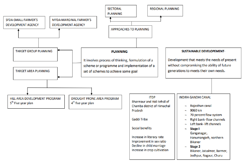
Planning is the process of thinking formulation of a scheme of programme and implementation of a set of actionsto achieve some goal
THERE ARE TWO APPROACHES
1. Sectorial planning
2. Regional planning
3. India started five year plans and annual plans target area planning
1. These plans take care of economically back ward areas, based on resoruces
2. Govt. introduced the following programmes under target area planning
1. Command area development Programme
2. Drought prone area development Programme
3. Desert area development programme
4. Hill area development programme
5. The small farmers development agency
6. Marginal farmers developmentAgency
HILLAREA DEVELOPMENT PROGRAMME
1. Started during 5th plan
2. Covered 15 district of Uttar Pradesh,West Bengal & Tamil Nadu
3. National committeeon the development of backward areain 1981 recommended this programme
4. Selected the area above 600 mts.
5. Covered tribal regions
6. Objectives are to develop: horticulture, plantation, animal husbandry, and poultry forestry small scale and village industries
DROUGHT PRONE AREA DEVELOPMENT PROGRAMME
1. Started during 4th plan
2. Objectives: employment, creating productive assets, starting labor Intensive works, irrigation projects, land development. Programme. Afforestation, grassland dev. Electricity, road, market, credit facility.
3. Integrated watershed dev. Pro
4. Restoration of ecological balance between water, soil, plants and animals
5. Covered 67 districts
PLANNING AND SUSTAINABLE DEVELOPMENT
Planning is the process of thinking formulation of a scheme of program and implementation of a set of action to achieve some goal.
THERE ARE TWO APPROACHES
- Sectorial planning - Regional planning
- India started five year plAnswer. and annual plAnswer.
TARGET AREA PLANNING
- This plan take care of economical back ward areas, based on resources
- Govt. introduced the following programmes under
TARGET AREA PROGRAMMES
- Command Area Development Programme
- Drought Prone Area Development Programme
- Desert Development Programme
- Hill Area Development Programme
TARGET GROUP PROGRAMMES
Target groups has the following programmes such as:
- The Small Farmers Development Agency (SFDA)
- Marginal Farmers Development Agency (MFDA)
HILL AREA DEVELOPMENT PROGRAMME
- Started during 5th plan
- covered 15 district of Uttarakhand,. West Bengal, Assam & Tamil Nadu
- National committee on the development of backward area in 1981 recommended this programme
- Selected the area above 600 mts.
- Covered tribal regions
- Objectives are: horticulture, plantation, animal husbandry, poultry forestry small scale and village industries
DROUGHT PRONE AREA DEVELOPMENT PROGRAMME
- Started during 4th plan
- Objectives: employment, creating productive assets, starting labor intensive works, irrigation projects, land development. Programme. Afforestation, grassland dev. Electricity, road, market, credit facility.
- Integrated water shed dev. Pro
- restoration of ecological balance between water, soil, plants and animals
- Covered 67 districts
CASE STUDY TRIBAL DEVELOPMENT PROGRAMME
- Bhaurmur Tribal region located in chambray district. of HP
- Inhabited by Gaddi tribes 3. They practice trAnswer.humance
- Total area is 1818 sq.km 1500 to 3700 mts altitude
- Ravi and its tributaries drain this region
- There are 4 physiographic regions1. Holi 2. Khani 3. Kugti 4. Tundah
- Harsh climate, low resource base, fragile environment
- 20/sq km density
- Most economically backward
- Socio economic deprivation
- Objectives: trAnswer.port and communication Agriculture. Allied activities. Socio economic. Services, education, health, potable water, electricity
SUSTAINABLE DEVELOPMENT
Development that needs of present without compromising the needs of future generations. It take care of ecological, social economic, aspects of present and pleads for conservation of resource for future
INDIRA GANDHI CANAL COMMAND AREA– RAJASTHAN CANAL
1. One of the largest canal system in India
2. Started in 1948 launched on 31/3/1958
3. Started from Harike barrage in Punjab run parallel to the Pakistan border
4. The total length is 9060 km 19.63 lakh hectare irrigation 70% flow 30%lift system
5. Started in two stages
6. CoverGanganagar,HanumanGarh,Bikanir, Jaisalmer,Barmer, Jodhpur,Nagpur,ChuruDistricts
7. Left side lift system and right side flow system of irrigation
8. Stage-I -1960 and stage-II - 1980
9. Objectives achieved : irrigation, pasture development, afforestation reducewind erosion, reducesiltation. Development of per-capita income, increasein food production, increase cultivated area, changein cropping system
10. Problems: siltation, waterlogging, salinity
11. STEPS TAKEN TO SOLVE THE PROBLEMS
1. Strict implementation of water management policy
2. Protective irrigation
3. Extensive irrigation of crops and pasture lands
4. No water intensive crops
5. Lining of water courses
6. Leveling of warabandhi
7. Reclamation ofwater logging areas
8. Afforestation, shelterbelts,
9. Adequate financial support
EFFECTS OF ITDP
- Increase literacy rate
- Improvement in sex ratio
- Higher female literacy
- Reduced gender inequality
- shift to cash crops
SUSTAINABLE DEVELOPMENT
A Development that meets the needs of present without compromising the ability of future generations to meet their own needs. It takes care of ecological, social economic, aspects of present and pleads for conservation of resource for future
CASE STUDY INDIRAGANDHI CANAL COMMAND AREA – RAJASTHAN CANAL
- One of the largest canal system in India
- Started in 1948 launched on 31/3/1958
- started from Harike barrage in Punjab run parallel to the Pakistan border
- The total length is 9060 km 19.63 lakh hectare irrigation 70% flow 30% lift system
- Started in two stages
- cover Ganganagar, Hanuman Garh, Bikanir, Jaisalmer, Barmer, Jodhpur, Nagaur, Churu Districts
- Left side lift system and right side flow system
- Stage one -1960 and stage ii 1980
- Objectives achieved : irrigation, pasture development, afforestation reduce wind erosion, reduce siltation. Development of per-capita income , increase in food production, increase cultivated area, change in cropping system
- problems: siltation, water logging
STEPS TAKE TO SOLVE THE PROBLEMS
- Strict implementation of water management policy
- Protective irrigation
- Extensive irrigation of crops and pasturelands
- No water intensive crops
- lining of water courses
- Leveling of wara bandhi
- Reclamation of water logging areas 8. Afforestation, shelterbelts,
- Adequate financial support
Question and Answer.
Question. When did NITI Aayog replace the Planning Commission?
(A) 18 March 2001
(B) 1 January 2015
(C) 28 June 2011
(D) 9May 2016
Answer. B
Question. In how many districts, drought-prone areas are identified:
(A) 47
(B) 57
(C) 67
(D) 77
Answer. C
Question. ITDP meAnswer. (A) Integrated tribal development project
(B) Indian tribal development project
(C) Indian tribal development program
(D) Integrated tribal development programme
Answer. A
Question. What should be the height of an area in the hill area development programme?
(A) 500 metres
(B) 600 metres
(C) 700 metres
(D) 800 metres
Answer. B
Question. What was the period of the First Five Year Plan?
(A) 1951 – 56
(B) 1950 – 55
(C) 1947 – 52
(D) 1960 – 65
Answer. A
Question. Hill area development programme does not include
(A) Horticulture
(B) Poultry
(C) Small scale industry
(D) Large scale industry
Answer. D
Question. On which factor does the economic development of a region depends?
(A) Relief
(B) Climate
(C) Population
(D) Resources
Answer. D
Question. By Which name was the Indira Gandhi Canal earlier known as?
(A) Gujarat Canal
(B) Rajasthan Canal
(C) Nehru Canal
(D) Bikaner Canal
Answer. B
Question. Aim of regional planning is
(A) Develop agriculture
(B) To improve roads
(C) To reduce regional imbalance
(D) To develop industry
Answer. C
Question. In which state in Bharmaur Tribal Region situated?
(A) Uttarakhand
(B) Jammu & Kashmir
(C) Himachal Pradesh
(D) Uttar Pradesh
Answer. C
Question. Regional planning relates to:
(A) Area differences in the trAnswer.portation network
(B) Development of rural areas
(C) Development of various sectors of the economy
(D) Area-specific approach of development
Answer. D
Question. Sectoral planning does not include
(A) Irrigation
(B) TrAnswer.port
(C) Hill area
(D) Infrastructure
Answer. C
Question. When did the Tenth Five Year Plan come to an end?
(A) 2005
(B) 2006
(C) 2007
(D) 2008
Answer. C
Question. Who conceived the idea of Indira Gandhi Canal?
(A) Sarvinder Singh
(B) Kanwar Sain
(C) Both A and B
(D) None of these
Answer. B
Question. Planning includes which of the following
(A) Process of thinking
(B) Formulation of schemes or programmes
(C) Implementation of set of actions to achieve goal
(D) All of above
Answer. D
Question. Which one of the following is the most crucial factor for sustainable development in Indira Gandhi Canal Command Area?
(A) Agricultural development
(B) Eco-development
(C) TrAnswer.port development
(D) Colonisation of land.
Answer. B
Question. What WCED stands for?
(A) World Commission on Environment and Development
(B) World Centre of Environment and Development
(C) Wildlife Commission on Environment and Development
(D) World Commission for Ecological Development
Answer. A
Question. Bharmaur ITDP includes
(A) Development of infrastructure
(B) Development of trAnswer.port
(C) Development of agriculture
(D) All of above
Answer. D
Question. Regional planning relates to:
(A) Development of various sectors of the economy
(B) Area-specific approach of development
(C) Area differences in the trAnswer.portation network
(D) Development of rural areas.
Answer. B
Question. Who wrote ‘The Population Bomb’?
(A) Ehrlich
(B) Meadows
(C) Amartya Sen
(D) None of these
Answer. A
Question. Negative influence of Indira Gandhi Canal command area includes
(A) Wind erosion
(B) Water logging
(C) Siltation
(D) Afforestation
Answer. B
Question. From which Barrage, Indira Canal has been taken out?
(A) Bhakra
(B) Nangal
(C) Harike
(D) Thein
Answer. C
Question. What changes have been brought in western Rajasthan due to the Indira Gandhi Canal?
Answer. Command Area Development Programme
- The Command Area Development Programme is an integrated area development approach towards the command areas of major and medium irrigation projects in the country.
- Aimed at bridging the gap between created irrigation potential and its utilisation.
- It is one of the major irrigation projects in India where this programme was introduced at the earliest. The importance of this programme is all the more in this command area because it requires efficient utilisation of irrigation water and overall economic and ecological development.
- To check desertification. Due to scarcity of rainfall, Thar Desert is rapidly advancing towards adjoining states. By afforestation and pasture development, the advance of this desert has been arrested.
- Drinking water. The water table is low in this area. Fresh water is supplied to rural areas.
- Development of trAnswer.port system. This trAnswer.port system is inadequate due to sandy area. This project will help in the development of trAnswer.port.
- It will provide communication and civic amenities which include construction of roads, connecting the settlements with markets, construction of new markets and supplying drinking water.
- Agricultural development. Agriculture is possible in fertile areas. Irrigation will help in cultivation of wheat, sugarcane, etc. It will overcome problem of famines.
- Farm development includes surveying and planning water course lining, land levelling, shaping and reclaimation of degraded lands.
- Industrial development. About 1200 cusecs water will be supplied to agro-based industries.
- Irrigation. On its completion, the canal will be able to irrigate 14 Lakh hectares of land.
- Implementation of this programme has helped in bringing the land under irrigation rapidly, increase in water-use efficiency, agricultural production and productivity.
- Afforestation. Afforestation and pasture development which includes canal side and roadside plantation, block plantation near new settlements, sand dune stabilisation and pasture development on culturable waste land.
- Cropping pattern. Deficiency in soil-moisture has been a limited factor for agricultural development in western Rajasthan. Farmers can raise crops during kharif season only and a large tract of cultivable land lies uncropped in the form of cultivable waste land and fallow land. Introduction of irrigation has helped in increasing the net sown and double cropped areas.
- In this region before introduction of irrigation, drought-resistant crops such as bajra, guar, moong, moth and gram occupied about 95 per cent of the gross cropped area. The cropping pattern of the region has changed drastically with the introduction of irrigation. As commercial crops such as cotton, groundnut, wheat and mustard have come up rapidly and occupy about 65 per cent of the gross cropped area in Stage I of the Canal Command Area.
- Wheat occupied about one-fourth of the gross cropped in the Canal Command Area in 1984-85 followed by cotton, mustard and guar. Groundnut is coming up as a major irrigated crop in kharif season in the lower parts of the command area.
- Agricultural production and productivity per hectare has increased rapidly in the command area of Indira Gandhi Canal. It will help in availability of modern agricultural inputs including ensuring supply of HYV seeds, chemical fertilisers, insecticides and pesticides and providing agricultural extension and training facilities to the farmers.
- Development of Pastures. It will help livestock rearing by bringing an area of 3.66 Lakh hectares under pastures.
- Civic amenities. This is a newly settled area and, therefore, requires civic amenities, infrastructural facilities and supply of modern agricultural inputs. It will increase employment opportunities. The population density will be increased. It will bring a socio-cultural and economic revolution in this area.
Question. Suggest the measures of promotion of sustainability in Indira Gandhi Canal Command Area.
Answer.
- There is an urgent need to strictly implement the water management policy.
- Water intensive crops should be avoided and instead plantation crops such as Citrus fruits should be encouraged.
- The Command Area Development programmes such as lining of water courses, land development, and levelling and warabandi system (equal distribution of canal water in the command area of outlet) shall be effectively implemented to reduce the conveyance loss of water.
- Efforts should be made to reclaim areas affected by water logging and soil salinity.
- Afforestation, shelter belt plantation and pasture development are necessary for eco-development.
- For achieving social sustainability, land allotted with poor economic background should be given sufficient financial and institutional support so that they can cultivate their land in a proper way.
- Other sectors of economy, in addition to agriculture, animal husbandry and allied activities, should be encouraged for attaining economic sustainability.
CBSE Class 12 Geography Chapter 9 Planning and sustainable Development Sources Based Question
Indira Gandhi Canal, previously known as the Rajasthan Canal, is one of the largest canal systems in India. Conceived by Kanwar Sain in 1948, the canal project was launched on 31 March, 1958. The canal originates at Harike barrage in Punjab and runs parallel to Pakistan border at an average distance of 40 km in Thar Desert (Marusthali) of Rajasthan. The total planned length of the system is 9,060 km catering to the irrigation needs of a total culturable command area of 19.63 lakh hectares. Out of the total command area, about 70 per cent was envisaged to be irrigated by flow system and the rest by lift system. The construction work of the canal system has been carried out through two stages. The command area of Stage-I lies in Ganganagar, Hanumangarh and northern part of Bikaner districts. It has a gently undulating topography and its culturable command area is 5.53 lakh
hectares. The command area of Stage-II is spread over Bikaner, Jaisalmer, Barmer, Jodhpur, Nagaur and Churu districts covering culturable command area of 14.10 lakh ha. It comprises desert land dotted with shifting sand dunes and temperature soaring to 50ºC in summers. In the lift canal, the water is lifted up to make it to flow against the slope of the land. All the lift canals of Indira Gandhi Canal system originate at the left bank of main canal while all the canals on the right bank of main canal are flow channels. Irrigation in Stage-I command area of the canal was introduced in early 1960s, whereas, the command area of Stage-II began receiving irrigation in mid-1980s. The introduction of canal irrigation in this dry land has trAnswer.formed its ecology, economy and society. It has influenced the environmental conditions of the region both positively as well as negatively. The availability of soil moisture for a longer period of time and various afforestation and pasture development programmes under CAD have resulted in greening the land. This has also helped in reducing wind erosion and siltation of canal systems. But the intensive irrigation and excessive use of water has led to the emergence of twin environmental problems of waterlogging and soil salinity.
Question. Which one of these is not an advantage of CAD.
(A) Reduces wind erosion
(B) Reduces siltation
(C) Reduces soil moisture
(D) All of the above
Answer. C
Question. When was Indira Gandhi canal launched?
(A) 30 March, 1968
(B) 31 March, 1958
(C) 31 March, 1957
(D) None of the above
Answer. C
Question. What do you mean by lift canal?
Answer. In lift canal, water is lifted up to make it to flow against the slope of the land with the use of pumps or surge pools.
CBSE Class 12 Geography Chapter 9 Planning and sustainable Development Very Short Answer Type Questions
Question. Mention two problems faced by India during the third five year plan.
Answer: Severed rought and war with China in 1962 and Pakistan in 1965.
Question. What were those two reasons due to which the eighth five year plan got delayed?
Answer: Political instability and liberalization policy.
Question. During which plan period Hill area development programme was initiated?
Answer: Fifth five year plan.
Question. Which major programme was initiated in fourth five year plan?
Answer: Drought prone area plan.
CBSE Class 12 Geography Chapter 9 Planning and sustainable Development Short Answer Type Questions
Question. What do you understand by planning? How is it a non going process?
Answer: The process involving the sequence of actions which are designed to solve problems in future is called planning.
Problems which are chosen for planning get changing from time to time. But these problems always remain economic and social. There is also a difference in level and period of planning from time to time. All types of planning have a sequence of action.
Question. Where were hill are development programme started?
Answer: In all 15 districts were included like Nilgiri ofTamilnadu,Kachhar hills of Assam,Darjeeling ofWest Bengal Mikir hills and Uttarakhand.
Question. Describe the drought prone area development programme and it’s main objective.
Answer: This programme was started in Fourth Five year plan to provide employmentin drought prone area.
Objectives:-
(i) To reduce the effect of drought
(ii) To initiate irrigation projects
(iii) Afforestation and pasture development
(iv) Restoration of ecological balance
v) Develop basic infrastructure like road, market, electricity etc.
Question. Define the Concept of Sustainable development?
Answer: The concept of Sustainable development refersto development in such away that it does not harm the environment and meets with the requirements of present and future generations.
Question. What do you understand by planning? How is it a non going process?
Answer: The process involving the sequence of actions which are designed to solve problems in future is called planning.Problems which are chosen for planning get changing from time to time. But these problems always remain economic and social. There is also a difference in level and period of planning from time to time. All types of planning have a sequence of action.
Question. Where were hill are development programme started?
Answer: In all 15 districts were included like Nilgiri of Tamilnadu, Kachhar hills of Assam, Darjeeling of West Bengal Mikir hills and Uttarakhand.
Question. Describe the drought prone area development programme and it’s main objective.
Answer: This programme was started in Fourth Five year plan to provide employmentin drought prone area.
Objectives:-
(i) To reduce the effect of drought
(ii) To initiate irrigation projects
(iii) Afforestation and pasture development
(iv) Restoration of ecological balance
(v) Develop basic infrastructure like road, market, electricity etc.
Question. Define the Concept of Sustainable development?
Answer: The concept of Sustainable development refers to development in such away that it does not harm the environment and meets with the requirements of present and future generations.
| CBSE Class 12 Geography Human Nature And Scope Worksheet |
| CBSE Class 12 Geography The World Population Distribution Density And Growth Worksheet |
| CBSE Class 12 Geography Population Composition Worksheet |
| CBSE Class 12 Geography Human Development Worksheet |
| CBSE Class 12 Geography Primary Activities Worksheet |
| CBSE Class 12 Geography Secondary Activities Worksheet |
| CBSE Class 12 Geography Tertiary And Quaternary Activities Worksheet |
| CBSE Class 12 Geography Transport And Communication Worksheet |
| CBSE Class 12 Geography International Trade Worksheet |
| CBSE Class 12 Geography Human Settlements Worksheet |
| CBSE Class 12 Geography Population Distribution Density Growth And Composition Worksheet |
| CBSE Class 12 Geography Water Resources Worksheet |
| CBSE Class 12 Geography Manufacturing Industries Worksheet |
| CBSE Class 12 Geography Planning And Sustainable Development In India Worksheet |
Worksheet for CBSE Geography Class 12 Chapter 9 Planning and Sustainable Development in Indian Context
We hope students liked the above worksheet for Chapter 9 Planning and Sustainable Development in Indian Context designed as per the latest syllabus for Class 12 Geography released by CBSE. Students of Class 12 should download in Pdf format and practice the questions and solutions given in the above worksheet for Class 12 Geography on a daily basis. All the latest worksheets with answers have been developed for Geography by referring to the most important and regularly asked topics that the students should learn and practice to get better scores in their class tests and examinations. Expert teachers of studiestoday have referred to the NCERT book for Class 12 Geography to develop the Geography Class 12 worksheet. After solving the questions given in the worksheet which have been developed as per the latest course books also refer to the NCERT solutions for Class 12 Geography designed by our teachers. We have also provided a lot of MCQ questions for Class 12 Geography in the worksheet so that you can solve questions relating to all topics given in each chapter.
You can download the CBSE Printable worksheets for Class 12 Geography Chapter 9 Planning and Sustainable Development in Indian Context for latest session from StudiesToday.com
There is no charge for the Printable worksheets for Class 12 CBSE Geography Chapter 9 Planning and Sustainable Development in Indian Context you can download everything free
Yes, studiestoday.com provides all latest NCERT Chapter 9 Planning and Sustainable Development in Indian Context Class 12 Geography test sheets with answers based on the latest books for the current academic session
CBSE Class 12 Geography Chapter 9 Planning and Sustainable Development in Indian Context worksheets cover all topics as per the latest syllabus for current academic year.
Regular practice with Class 12 Geography worksheets can help you understand all concepts better, you can identify weak areas, and improve your speed and accuracy.