
Read and download free pdf of CBSE Class 12 Geography International Trade Worksheet. Students and teachers of Class 12 Geography can get free printable Worksheets for Class 12 Geography Chapter 9 International Trade in PDF format prepared as per the latest syllabus and examination pattern in your schools. Class 12 students should practice questions and answers given here for Geography in Class 12 which will help them to improve your knowledge of all important chapters and its topics. Students should also download free pdf of Class 12 Geography Worksheets prepared by teachers as per the latest Geography books and syllabus issued this academic year and solve important problems with solutions on daily basis to get more score in school exams and tests
Worksheet for Class 12 Geography Chapter 9 International Trade
Class 12 Geography students should download to the following Chapter 9 International Trade Class 12 worksheet in PDF. This test paper with questions and answers for Class 12 will be very useful for exams and help you to score good marks
Class 12 Geography Worksheet for Chapter 9 International Trade
GIST OF THE LESSON:
TWO LEVELS OF TRADE
NATIONALAND INTERNATIONAL
The initial trade was barter system in which goods are exchanged Before currency there were flint stones, obsidian, cowries shells tigers paw, whales teeth dogs teeth skins furs cattle rice pepper corns salt small tools copper silver and gold.
HISTORY OF INTERNATIONAL TRADE
• Trade was restricted to small distance due to theft
• People used to satisfy their immediate facilities
• Only rich people used to bring jewellary and other ornaments
• The silk route is an example connecting with china and Rome
• Wool silk precious stones; were trade
• After Rome disintegration it was not given importance
• The slave trade was started with the colonization
• After industrial revolution raw material and finished products are given importance
• During world wars many countries imposed taxes
• After the world war GATT was formed
WHY DOES INTERNATIONAL TRADE EXIST
1. Specialization in production
2. Division of labor
3. Comparative advantage
4. Complementarily and transferability of goods & services
5. Mutual benefit 6.foreign policy
7.developed transport and communication
BASIS OF INTERNATIONAL TRADE
DIFFERENCE IN NATIONAL RESOURCES
• Geological structure
• Mineral resources
• Climate
• Population factors
• Cultural factors
• Size of population
• Stage of economic development
• Extent of foreign investment
• Transport
IMPORTANTASPECTS OF INTRNATIONAL TRADE
• Volume of trade
• Composition of trade
• Direction of trade
• Balance of trade
TYPES OF INTERNATIONAL TRADE
• Bilateral trade
• Multilateral trade
CASE FOR FREE TRADE
DUMPED GOODS
DUMPING - The Practice of selling commodity in two countries at a price that differs for reasons not related to costs is called Dumping.
WTO
• GATT was formed in 1948
• The GATT was transformed in toWTO on 1.1.1995
• It maintains the global rules between the nations
• It resolves the disputes between the nations related to trade
• It covers trade services, telecommunication and banking, intellectual rights
• It gives importance to rich nations
• It is not favour to poor nations
REGIONAL TRADE BLOCS ASEAN, CIS, EU, LAIA, NAFTA, OPEC, SAFTA CONCERNS RELATED TO INTERNATIONAL TRADE
• Regional specialization
• Higher level of production
• Better standard of living
• World wide availability of goods and services
• Equalization of prices and wages
• Diffusion of knowledge and culture
• Leads to dependence
• Uneven level of development
• Exploitation
• Commercial revelry leads to wars
• Affect life
• Increase in production and consumption of resource
• Depletion of resources
• More pollution
GATEWAYS OF INTRNATIONAL TRADE PORTS
• Provide facilities to cargo and passenger
• Provide docking, loading unloading, storage facilities for cargo
• Maintain navigable channels
• Arrange tugs and barges, provide labor managerial services
• The quantity of cargo handled by the port is an indicator of level of development of its hinter land
TYPES OF PORT BASED ON CARGO HANDLED
1. Industrial ports 2. Commercial ports 3. Comprehensive ports
BASED ON LOCATION
1. Inland ports 2.outports
BASED ON SPECIALISED FUNCTION
1. Oil ports 2. Ports of call 3. Packet station 4.Entre pot ports 5. Naval ports
INTERNATIONAL TRADE

- India’s contribution to world trade-less than 1%
Changing pattern of India’s international trade
- 1950-51-external trade worth-1214 crore
- 2016-17-external worth-4429762 crore
Reasons for increase in trade
1. Better performance by manufacturing sector
2. Liberal policies of the government
3. Diversification of market
- Import value more than export value- so trade deficit
Reason- price rise of crude petroleum
Changing pattern of the composition of India’s export
1. Share of agriculture and allied products[coffee, tea, pulses and spices] has declined[tough international competition]
2. Share of petroleum and crude products have increased [1. Rise in petroleum prices 2. Increase in India’s refining capacity]
3. Shares of ore minerals and manufactured goods have largely remained constant over the years
4. Increase registered in floricultural products, fresh fruits, marine products, sugar
5. Manufacturing sector alone accounted for 73.6% of India’s total value of export in 2016-17
6. Engineering goods have shown a significant growth
7. Textile sector could not achieve much in spite of liberal measures taken by government[competition from china, east Asian countries]
8. Gems and jewellry contributes a larger share of India’s foreign trade.
Changing pattern of the composition of India’s import
1. During 1950’s and 60’s major item of import was food grains, capital goods, machinery and equipment
2. After 1970’s import of food grain discontinued[success of green revolution] and was replaced by fertilizers and petroleum
3. Major imports- machine and equipment, special steel, edible oil, chemicals.
4. Steep rise in import of petroleum products [1. Rising industrialization 2. Better standard of living 3. Price rise in international market]
5. Import of capital goods maintained a steady increase[non electric machinery, transport equipment, manufacturers of metals and machine tools]
6. Other major items of India’s import-pearls, semi precious stones, gold, silver, metalliferous ores, metal scarp, non ferrous metals, electronic goods
Direction of trade
India has trade relations with most of the countries and trading blocs
Aims to double its share in international trade in next 5 years-measures taken
1. Import liberalization
2. Reduction in import duties
3. Delicensing
4. Change from process to product patent
- Most of the trade by sea and air routes.
- Small portion of trade by land route[ Nepal, Bhutan, Bangladesh, Pakistan]
Sea ports
- 12 major ports[handle 71% of oceanic traffic]-central government
- 185 minor ports- state government
- West coast has more sea ports
- Partition snatched away 2 ports
1. Karachi port[Pakistan] compensated- Kandla[Gujarat]
2. Chittagong port[Bangladesh]-compensated by diamond harbor[west Bengal]
Major ports
Airports
25- International airports.
1. Ahmedabad
2. Bangalore
3. Chennai
4. Delhi
5. Goa
6. Guwahati
7. Hyderabad
8. Kolkata
9. Mumbai
10. Thiruvananthapuram
11. Srinagar
12. Jaipur
13. Calicut
14. Nagpur
15. Coimbatore
16. Cochin
17. Lucknow
18. Pune
19. Chandigarh
20. Mangaluru
21. Vishakhapatnam
22. Indore
23. Patna
24. Bhubaneshwar
25. Kannur
Question. Which of these port is situated at the entrance of the Zuari estuary?
(a) Mumbai port
(b) Chennai port
(c) Marmagao port
(d) Haldia port
Answer : C
Question. Which of the following ports is not located on the East coast of India?
(a) Kolkata port
(b) Paradwip port
(c) Tuticorin port
(d) Mangaluru port
Answer : D
Question. Which of the following ports have been arranged correctly from North to South?
(a) Kolkata, Paradwip, Visakhapatnam, Chennai
(b) Chennai, Kolkata, Paradwip, Visakhapatnam
(c) Kolkata, Chennai, Paradwip, Visakhapatnam
(d) Chennai, Paradwip, Visakhapatnam, Kolkata
Answer : A
Question. Which of the following is not an international airport of India?
(a) Bhopal
(b) Bengaluru
(c) Chennai
(d) Nagpur
Answer : A
Question. Which of the following is an inland port?
(a) Kochchi port
(b) Ennore port
(c) Haldia port
(d) Kolkata port
Answer : D
Question. Paradwip port is located in the delta of which of these rivers?
(a) Godavari
(b) Ganga
(c) Krishna
(d) Mahanadi
Answer : D
Question. There has been a significant rise in India’s International trade. This is due to
(a) rapid growth in manufacturing sector
(b) liberal policies of the government
(c) diversification of markets
(d) All of the above
Answer : D
Question. Kolkata port has lost its significance an account of the diversion exports to which port?
(a) Visakhapatnam
(b) Paradwip port
(c) Haldia port
(d) All of these
Answer : D
Question. In which state is Nhava Sheva port located?
(a) Gujarat
(b) Goa
(c) Maharashtra
(d) Karnataka
Answer : C
Question. Which port is called the ‘Queen of Arabian Sea’?
(a) Mangalore
(b) Cochi
(c) Mumbai
(d) Kandla
Answer : B
Question. Which of the following is the hinterland of Kolkata port?
(a) Sikkim
(b) Uttar Pradesh
(c) West Bengal
(d) All of these
Answer : D
Question. Which of the following sector has seen a decline in the composition of exports of India in the last decade?
(a) Manufactured goods
(b) Petroleum products
(c) Agriculture and Allied products
(d) Minerals ores
Answer : C
Question. Trade between two countries is termed as:
(a) Internal trade
(b) International trade
(c) External trade
(d) Local trade
Answer : B
Question. Which one of the following is a land-locked harbour?
(a) Visakhapatnam
(b) Mumbai
(c) Ennore
(d) Haldia
Answer : A
Question. Most of India’s foreign trade is carried through:
(a) Land and sea
(b) Land and air
(c) Sea and air
(d) Sea
Answer : C
Question. Which one of the Indian sea ports provides facilities to the land-locked neighbouring countries?
(a) Nhava Sheva
(b) Kandla
(c) Kolkata
(d) Visakhapatnam
Answer : C
Question. Which of these is an artificial port/harbour?
(a) Mumbai port
(b) Kochchi port
(c) Chennai port
(d) Marmagao port
Answer : C
Question. Which of the following is a satellite port of Chennai port?
(a) Kolkata port
(b) Haldia port
(c) Tuticorin port
(d) Paradwip port
Answer : C
Question. Which of the following is not an important item which India imports from other countries?
(a) Petroleum and petroleum products
(b) Food grains
(c) Machinery
(d) Transport equipment
Answer : B
Question. Which sector accounts for largest value of India’s export basket?
(a) Manufacturing
(b) Service sector
(c) Agricultural sector
(d) Dairy sector
Answer : A
Question. Which of these products and commodities constitute the export basket of India?
1. Manufactured goods
2. Crude and petroleum products
3. Ores and minerals
Codes
(a) 1 and 2
(b) 1, 2 and 3
(c) 2 and 3
(d) 1 and 3
Answer : B
Question. Which of the following is true in the context of International trade of India?
1. There has been an increase in volume of imports and exports over the years.
2. The value of imports are higher than the value of exports.
Codes
(a) Only 1
(b) Only 2
(c) Both 1 and 2
(d) None of these
Answer : C
Question. Which of these commodities constitute the imports of India from other countries?
1. Machines and equipments
2. Edible oil
3. Fertilisers
4. Iron and steel
Codes
(a) 1, 2 and 3
(b) 1, 2, 3 and 4
(c) 2, 3 and 4
(d) 1, 2 and 4
Answer : B
Question. Which of the following measures have been adopted by India to expand its share in the International Trade?
1. Trade liberalisation
2. Increasing export duties
3. Delicencing of industries
Codes
(a) 1 and 2
(b) 1 and 3
(c) 1, 2 and 3
(d) 2 and 3
Answer : B
Question. Match the following correctly and choose the correct answer.
List I (Port) List II (Satellite port)
A. Mumbai port 1. Hughli port
B. Chennai port 2. Jawaharlal Nehru port
C. Kolkata port 3. Ennore port
Codes
A B C
(a) 3 1 2
(b) 3 2 1
(c) 2 3 1
(d) 2 1 3
Answer : C
One marks question
Question. Define the term Hinterland.
Answer: Service land in and around a port.
Question. India is the member of which trading block?
Answer: Safta
Question. Which association is the largest single market in the world?
Answer: European union (EU)
Question. Which port has been constructed to reduce congestion of Kolkata port?
Answer. Haldia
Question. Which one of the Indian sea ports provides port facilities to its land locked neighbouring countries? Name any one such country
Answer. Kolkata
Nepal
Question. Which satellite port eases the pressure on Mumbai port?
Answer. Jawaharlal Nehru port
Question. Name the land locked seaport of India. In which state is it located?
Answer. Vishakhapatnam
Andhra Pradesh
Question. Name the riverine seaport located in west bengal
Answer. Kolkata
Question. Name the sea port situated on Zuari estuary
Answer. Marmagao
Question. Name the southrern most port of mainland of India
Answer. Tuticorin
Question. Mention the reasons for sharp rise in overseas trade over the years?
Answer. 1. Better performance by manufacturing sector
2. Liberal policies of the government
3. Diversification of market
Question. Describe any five features of changing patterns of the composition of India’s import
Answer. 1. During 1950’s and 60’s major item of import was food grains, capital goods, machinery and equipment
2. After 1970’s import of food grain discontinued[success of green revolution] and was replaced by fertilizers and petroleum
3. Major imports- machine and equipment, special steel, edible oil, chemicals.
4. Steep rise in import of petroleum products [1. Rising industrialization 2. Better standard of living 3. Price rise in international market]
5. Import of capital goods maintained a steady increase[non electric machinery, transport equipment, manufacturers of metals and machine tools]
6. Other major items of India’s import-pearls, semi precious stones, gold, silver, metalliferous ores, metal scarp, non ferrous metals, electronic goods
Question. Describe any five features of changing patterns of the composition of India’s export
Answer. 1. Share of agriculture and allied products[coffee, tea, pulses and spices] has declined[tough international competition]
2. Share of petroleum and crude products have increased [1. Rise in petroleum prices
2. Increase in India’s refining capacity]
3. Shares of ore minerals and manufactured goods have largely remained constant over the years
4. Increase registered in floricultural products, fresh fruits, marine products, sugar
5. Manufacturing sector alone accounted for 73.6% of India’s total value of export in 2016-17
6. Engineering goods have shown a significant growth
7. Textile sector could not achieve much in spite of liberal measures taken by government[competition from china, east Asian countries]
8. Gems and jewellry contributes a larger share of India’s foreign trade.

Question. Name the major seaport of Andaman and Nicobar islands.
Answer. Port Blair
Question. Name a port of Maharashtra and a port of Tamil Nadu which have been constructed to reduce the pressure on the existing major ports.
Answer. Jawaharlal Nehru Port
Ennore/Tuticorin
Question. Name two states which have two major ports
Answer. Maharashtra
Tamil Nadu
West Bengal
Question. Why are ports always referred to as gateway of International trade?
Answer. The world port is derived from the latin word “Porta” meaning Gateway.
Port is a connecting link between land and water.
It is a place on the coast where ships start and end their journey.
Here reached Cargo is unloaded and the Cargo which is to be exported is loaded Port provides facilities of export and import
It is well connected to the interior of the country by a good network of roadways and railways
Question. What are the function of WTO?
Answer. (1) Solve disputes among the countries.
(2) Provide trade services.
(3) Deals with the global rules of trade between nations.
Question. What is international trade? Which are the two types of international trade ? Give one characteristics of each.
Answer. International Trade- The movement of goods and Services from areas of Surplus to deficit area between two countries.
The two types of international trade
1. Bilateral trade- The exchanging of good between two countries.
2. Multilateral trade- The exchange takes place between several countries on regular basis.
Question. Classify ports on various bases.
Answer. On the basis of Cargo handled
1. Industrial ports
2. Commercial ports
3. Comprehensive
On the basis of location
1. Inland ports
2. Outports
On the basis of specialized functions
1. Oil ports
2. Ports of call
3. Packet stations
4. Entre port
5. Naval ports.
GIST OF THE LESSON:
CHANGES IN INTERNATIONAL TRADE
1. There is a change in volume that is increased but the value of import is more than export
• Increase in trade deficit
• It is due to rise of petroleum price
CHANGES IN COMPOSITION
• The share of agriculture and allied products has declined
• The share of petroleum products has increased
• The share of ore-minerals and manufactured goods have largely remained constant
• Increasing in India’s refining capacity also responsible for importing petroleum
• Declining in traditional goods is due to tough international competition
• There is a great decline in coffee, spices, pulses, tea
• Increase in floriculture products, marine products, sugar and fresh fruits
• Manufacturing alone accounted for 75.96%
• Engineering goods have show growth in export
• China and east Asian countries are our competitors
• Gems and jewellery contributed a large share in foreign trade
CHANGING PATTERN OF INDIAS IMPORT
1. Earlier our import was food grains, capital goods, machinery 2.After 1970 import of food grains discontinued
3. Fertilizers and petroleum took major part
4. Machine, edible oil and chemicals also present 5.capital goods has steadily increasing
• Food products reduced
• Pearls and precious stones gold and silver take major part
DIRECTION OF TRADE
Export: 47.41%= Asia and Oceania 23.80%West Europe 20.42% Ameirca
Import: 35.40% Asia Oceania 22.60%West Europe 8.36% America
The china is the largest trading partner of India
India export with UK, Belgium, Germany, Japan, Switzerland and Hongkong the UAE, China Singapore.
Sea Ports are called International GateWays of International Trade
• India is covered by three side with water
• Longest coast line (7516,5 km)
• water is the cheapest transport
• West coast has more sea ports than east coast
• Most of the international trade takes place through sea routes
• Major ports are controlled by central govt. Minor ports are under different state governments
• There are 12 major and 185 minor ports
• Most of the ports are equipped with modern facilities
INDIAN SEAPORTS
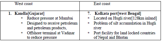
• KANDLA: located at Gulf of KACHCH,
Developed to decrease pressure on Mumbai port, Special facilities are available for petroleum The offshore Vadinar is developed to reduce pressure on this port
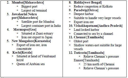
• MUMBAI: natural harbor, biggest port, suitable to import goods from middle east countries, 20km long and 10 km width country s largest oil terminal
JAWAHARLAL NEHRU PORT:
• Located at Nhava Seva,
• Largest after completion,
• Developed to decrease burden on Mumbai port
MARMAGOA PORT:
• Located at the estuary of Zuari river
• Natural harbor
• Iron ore is exported to Japan
• Konkan railway brought large hinter land
NEWMANGALORE PORT
• Located in Karnataka coast
• Specialized to expert of iron ore
• Also exports fertilizers , tea , wood pulp yarn
KOCHIN PORT
• Located at the Vembanad kayal
• Queen of Arabian sea
• Natural harbor
• Close to Suez canal
KOLKATA PORT
• Located on the Hugli river bank
• Located 128 km away from sea coast
• Developed by British
• Paradip and Haldia decreased the pressure
• Silt accumulation is the problem
• Large hinter land
• Extend port facilities to other countries
HALDIAPORT
• Located 105 down stream of Hugli
• Developed to burden on Kolkata
• Handles iron ore , cargo fertilizers, jute products
PARADIP PORT
• Located on Mahanadi delta
• 100 km from Cuttack
• Deepest harbor
• Handle large vessels
• Developed to iron ore
VISHAKAPATNAM PORT
• Land locked harbour
• Connected to the sea through channel
• An outer harbor is developed to help this port
• It handles iron ore, petroleum cargo
CHENNAI PORT
• Oldest port developed by British
• Artificial harbor
• Not suitable for large ships
ENNORE PORT
• Newly developed port in Tamil Nadu
• Located 25 km north of Chennai
• Developed to decrease burden on Chennai port
TUTICORIN PORT
• Newly developed port in Chennai
• It handles variety of cargo: coal, salt, edible oils, petroleum & food grains
• Developed to decrease pressure on Chennai port
AIR TRANSPORT
• Fastest
• Connect remote areas
• Suitable for long distance
• Help at the time of disasters
• 12 Intrnational and 112 Domestic Ports
Ahmedabad, Amritsar, Banglore, Chennai, Delhi, Goa, Guwati, Hyderabad, Kochchi, Kolkata, Mumbai, Trivendrum
One Mark Questions
Question. What is meant by international trade?
Answer: Exchange of goods and services at international level.
Question. Name the land locked harbor of India?
Answer: Vishakhapatnam
Question. Name the northern most international airport of India?
Answer: Amritsar
Three Marks Question
Question. What are the causes of trade imbalance of India ?
Answer:
1. High price at world level
2. Devaluation of Indian rupee at international trade
3. Slow progress in production in India .
4. Increasing domestic demand in India.
Question. Why are ports called as gateways of trade in India?
Answer: (i) Import and export by ports only.
(ii) Can reach upto sea through ports only.
(iii) Ports provide link with other countries.
Question. Why does India edible oil and pulses inspite of being on agriculturally rich country?
Answer:1. Demand due to excessive population
2. Most of the cultivated land under food ex.
3. Low per hectare productivity of pulses.
4. Less profitable as compare to other crops.
5. Risky farming due to high vulnerability.
Five marks question.
Question. Write main characteristics of India’s foreign Trade.
Answer: Main characteristics of Indian Trade
1. Mostly trade through sea
2. Lack of foreign trade.
3. Reduction in per capita trade.
4. Result of trade and increase of price
5. Negative trade balance-
6. Characteristics of export trade
(i) Maximum of traditional articles.
(ii) More export of engineering and prepared articles from industries.
(iii) More customer (Buyer) of India’s exported goods
(iv) Change the direction of trade
7. Characteristics of import trade-
(i) Maximum of heavy machineries in trade.
(ii) Increase of manufactured of articles.
(iii) Reduction in food grains and raw materials.
| CBSE Class 12 Geography Human Nature And Scope Worksheet |
| CBSE Class 12 Geography The World Population Distribution Density And Growth Worksheet |
| CBSE Class 12 Geography Population Composition Worksheet |
| CBSE Class 12 Geography Human Development Worksheet |
| CBSE Class 12 Geography Primary Activities Worksheet |
| CBSE Class 12 Geography Secondary Activities Worksheet |
| CBSE Class 12 Geography Tertiary And Quaternary Activities Worksheet |
| CBSE Class 12 Geography Transport And Communication Worksheet |
| CBSE Class 12 Geography International Trade Worksheet |
| CBSE Class 12 Geography Human Settlements Worksheet |
| CBSE Class 12 Geography Population Distribution Density Growth And Composition Worksheet |
| CBSE Class 12 Geography Water Resources Worksheet |
| CBSE Class 12 Geography Manufacturing Industries Worksheet |
| CBSE Class 12 Geography Planning And Sustainable Development In India Worksheet |
Worksheet for CBSE Geography Class 12 Chapter 9 International Trade
We hope students liked the above worksheet for Chapter 9 International Trade designed as per the latest syllabus for Class 12 Geography released by CBSE. Students of Class 12 should download in Pdf format and practice the questions and solutions given in the above worksheet for Class 12 Geography on a daily basis. All the latest worksheets with answers have been developed for Geography by referring to the most important and regularly asked topics that the students should learn and practice to get better scores in their class tests and examinations. Expert teachers of studiestoday have referred to the NCERT book for Class 12 Geography to develop the Geography Class 12 worksheet. After solving the questions given in the worksheet which have been developed as per the latest course books also refer to the NCERT solutions for Class 12 Geography designed by our teachers. We have also provided a lot of MCQ questions for Class 12 Geography in the worksheet so that you can solve questions relating to all topics given in each chapter.
You can download the CBSE Printable worksheets for Class 12 Geography Chapter 9 International Trade for latest session from StudiesToday.com
There is no charge for the Printable worksheets for Class 12 CBSE Geography Chapter 9 International Trade you can download everything free
Yes, studiestoday.com provides all latest NCERT Chapter 9 International Trade Class 12 Geography test sheets with answers based on the latest books for the current academic session
CBSE Class 12 Geography Chapter 9 International Trade worksheets cover all topics as per the latest syllabus for current academic year.
Regular practice with Class 12 Geography worksheets can help you understand all concepts better, you can identify weak areas, and improve your speed and accuracy.