
Read and download the Class 7 Social Science Our Changing Earth B Exam Notes. Designed for 2026-27, this advanced study material provides Class 7 Social Science students with detailed revision notes, sure-shot questions, and detailed answers. Prepared by expert teachers and they follow the latest CBSE, NCERT, and KVS guidelines to ensure you get best scores.
Advanced Study Material for Class 7 Social Science Our Environment Chapter 3 Our Changing Earth
To achieve a high score in Social Science, students must go beyond standard textbooks. This Class 7 Our Environment Chapter 3 Our Changing Earth study material includes conceptual summaries and solved practice questions to improve you understanding.
Class 7 Social Science Our Environment Chapter 3 Our Changing Earth Notes and Questions
MAJOR LANDFORMS
The endogenic forces operating in the interior of the earth help in the formation of landforms on the surface of the earth.
1. The exogenic forces, which derive their energy from the Sun, act on the surface of the earth through several processes, like weathering, mass wasting, erosion, transportation, deposition, etc.
2. Weathering, depends on climatic elements, basically involves disintegration or decay of solid rocks. It is a static process and does not involve the removal of rocks.
3. The weathering of rocks can occur through physical forces, chemical forces, biological forces, etc.
4. Weathering prepares rock material for transportation by the agents of gradation like rivers, glaciers, wind, sea waves. etc.
→ RIVER AS AN AGENT OF CHANGE
The rivers generally originate in mountains, either from the glaciers or from the lakes. Some rivers, say in the Deccan Plateau of India, are formed due to meeting of various streams during the rainy season.
1. The place of origin of a river is called its source.
2. Where a river enters the sea or disappears before joining the sea, is called its mouth.
3. The streams or small rivers which join the main river are called its tributaries.
4. From the source to its mouth, a river can be divided into three main sections – the Upper Course, the Middle Course and the Lower Course. These are also known as the young, mature and old stages.
→ THE UPPER COURSE
The upper course of a river generally lies in the hilly areas. Due to steep slope, the river flows very swiftly and erodes its bed and banks. Many types of landforms develop due to the erosional work of the river in the upper course.
1. If there is hard and resistant rock in the course of the river, the water in the river will fall from a great height forming a waterfall.
2. Jog Falls is the highest waterfall in India, while the Angel Falls in Venezuela South America) is the highest in the world.
3. A steep-sided deep valley in the hilly areas is called a gorge or a canyon.
4. River valleys normally develop in areas of heavy rainfall and when the rocks are not very hard.
5. Such features are called the V-shaped Valley.
→ THE MIDDLE COURSE
of the river decline. The volume of water in the river increases. Thus, the broadening of river is more active than its deepening.
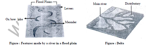
1. At this stage in the middle course, the river twists and turns forming large bends and loops, known as meanders.
2. These are formed due to the erosional and depositional work of the river.
3. The meanders are generally formed when the slope is gentle and the river has enough water
4. There is a continuous erosional and depositional work along the sides of meanders'.
5. This causes the ends of the meanders' loop come closer.
6. After some time, the meanders' loops cuts off from the main river, and the leftover part is called an ox-bow lake.
7. Sometimes, especially during floods, the river overflows its banks and causes flooding of the surroundings areas.
8. The river deposits the sediments, brought by it, in this region. This activity leads to the development of fertile flood-plains
9. The river also deposits some sediments on and along the banks, which are raised to a higher level than the plains on the either side of the bank. The raised banks are called the natural levees or just levees.
→ THE LOWER COURSE
1. As the river approaches the sea or any other large body of water, the speed of the river water declines and its capacity to transport sediments is drastically reduced.
2. This leads to the deposition of sediments on the floor of the river. Thus, the river is also divided into many distributaries.
3. In many rivers, each distributary may develop its own mouth.
4. The deposition of sediments over a large area, results in a triangular shaped formation, which is known as the delta.
5. The Ganga and the Brahmaputra rivers together from the largest delta in the world. All rivers do not form delta. Flood Plains
→ ICE AS AN AGENT OF CHANGE
snow is more than its melting . A glacier moves under the influence of gravity along a confined course away from its region of accumulation
1. The height above which there is a permanent cover of snow is known as the snowline.
2. The area of permanent cover of snow above the snowline is called the snow-field.
3. The glaciers are the broadest at the source and the narrowest where they end.
4. A glacier moves slowly in the beginning. Its speed is more in the middle part than on the sides. The average rate of movement is about one meter per day. The velocity depends upon the steepness of slope.
5. Deep cracks, called crevasses, are formed on the surface of a glacier when its movement is checked.
6. The work of the glacier causes erosional features in the mountains or highlands and depositional features in the lowlands
7. The glacier erodes the landscape by bulldozing the soil and the stones. This action can expose the solid rock below
8. It can carve out armchair shaped depression, which gets filled with snow.
9. As the snow or ice melts, these depressions get filled up with water. The depressions are called cirque, and the lakes thus formed are called tarn.
10. A glacial valley has a distinct U-shape, as against a V-shaped river valley. A glacier is able to erode, both the sides and bottom, with which it comes in contact. After erosion, it leaves behind a distinct U- shaped valley.
11. The tributaries or smaller glaciers develop waterfalls while entering the main valley. The waterfall when seen from the floor of the main valley appears like a hanging valley.
12. In the lowland regions, the glacier starts melting and this causes the deposition of sediments brought by the glacier. The debris and rock particles of all sizes and shapes are deposited over a small area. These deposits are called glacial moraines.
→ WIND AS AN AGENT OF CHANGE
1. The movement of air over the surface of the earth is known as wind. The work of the wind as an agent of change is generally associated with the arid and semi-arid regions. The prevailing winds are the main agent of soil erosion.
2. The speed of wind is very important in the erosional and the depositional work. The strong winds can pick up and carry sand particles and even gravel. When the speed of wind slows down, the sediments brought by the wind are deposited.
3. The continuous erosional work of the wind has created a large variety of physical features, especially in the hot deserts. A projecting rock in a dry area can develop into a mushroom shape due to the erosional work of the wind.
4. The maximum erosion of a projected rock occurs not at its ground level, but slightly above it.Generally, the wind erodes the lower part of the are projected rock more than the upper part. Thus, such rocks develop narrow base and wider top. These projected rock masses acquire the shape of a mushroom and are commonly called the mushroom rocks. way. The sand dunes are formed when the sand is deposited in the form of low hills. The sand dunes are composed of coarser material and are generally formed in groups. The sand dunes can migrate in the direction of wind.
6. The fine dust particles are deposited in big masses, beyond the limits of the desert margins. This is called loess deposits. It is a massive formation with no beds or stratas. About 10 percent of the earth surface is covered by loess deposits. The most extensive deposits of loess (yellow in colour) are found
in North China.
→ SEA WAVES AS AN AGENT OF CHANGE
1. The sea water does most of its erosional and depositional work through the sea waves.
2. The sea waves are generated due to the friction caused by the winds over the water surface.
3. The sea waves radiate outwards from the area of their origin.
4. The work of sea waves as an agent of change modifies the coastal areas. It is also knows as marine erosion.
5. The ability of the sea waves to do the erosional work depends upon the rock fragments carried by the water.
6. The sea waves continuously strike the rock masses in the coastal areas. The cracks in the rocks are widened as the water is forced into the cracks under very high pressure. This helps in breaking the rocks into smaller blocks.
7. In some coastal areas, a layer of soft rocks exists between two layers of hard rocks. The joints in the rocks are widened into large cavities. Over a period of time, they become larger and wider. Thus, hollow-like caves are formed, which are called the sea caves. They are frequently formed in the limestone and chalk regions.
8. Over period of time, the cavities are enlarged and only the roof of the cave remains, thus forming sea arches. When a headland projecting into sea, is struck by the sea waves on both sides, a through passage is created, which is called sea arch.
9. In due course of time, the agents of weathering and erosion break the upper portion of the arch, and the roof collapses. Thus, large pillars of rocks, completely detached from the main body of rocks is left behind. This is called stack.
10. Steep depositional work is a slow and steady process. When the capacity of the sea waves declines, the rock material brought by it is deposited in the offshore region.
11. Beaches are formed when the sea waves reach the coast diagonally, and the winds are of low velocity. Beaches along the coast of Goa, Mumbai and Chennai are very popular.
12. The strip rocky coast rising almost rustically above sea water is called sea cliff.
Please click on below link to download pdf file for Class 7 Social Science Our Changing Earth B Exam Notes
Free study material for Social Science
CBSE Class 7 Social Science Our Environment Chapter 3 Our Changing Earth Study Material
Students can find all the important study material for Our Environment Chapter 3 Our Changing Earth on this page. This collection includes detailed notes, Mind Maps for quick revision, and Sure Shot Questions that will come in your CBSE exams. This material has been strictly prepared on the latest 2026 syllabus for Class 7 Social Science. Our expert teachers always suggest you to use these tools daily to make your learning easier and faster.
Our Environment Chapter 3 Our Changing Earth Expert Notes & Solved Exam Questions
Our teachers have used the latest official NCERT book for Class 7 Social Science to prepare these study material. We have included previous year examination questions and also step-by-step solutions to help you understand the marking scheme too. After reading the above chapter notes and solved questions also solve the practice problems and then compare your work with our NCERT solutions for Class 7 Social Science.
Complete Revision for Social Science
To get the best marks in your Class 7 exams you should use Social Science Sample Papers along with these chapter notes. Daily practicing with our online MCQ Tests for Our Environment Chapter 3 Our Changing Earth will also help you improve your speed and accuracy. All the study material provided on studiestoday.com is free and updated regularly to help Class 7 students stay ahead in their studies and feel confident during their school tests.
FAQs
Our advanced study package for Our Environment Chapter 3 Our Changing Earth includes detailed concepts, diagrams, Mind Maps, and explanation of complex topics to ensure Class 7 students learn as per syllabus for 2026 exams.
The Mind Maps provided for Our Environment Chapter 3 Our Changing Earth act as visual anchors which will help faster recall during high-pressure exams.
Yes, teachers use our Class 7 Social Science resources for lesson planning as they are in simple language and have lot of solved examples.
Yes, You can download the complete, mobile-friendly PDF of the Social Science Our Environment Chapter 3 Our Changing Earth advanced resources for free.
Yes, our subject matter experts have updated the Our Environment Chapter 3 Our Changing Earth material to align with the rationalized NCERT textbooks and have removed deleted topics and added new competency-based questions.