
Read and download the Class 7 Social Science Our Changing Earth A Exam Notes. Designed for 2026-27, this advanced study material provides Class 7 Social Science students with detailed revision notes, sure-shot questions, and detailed answers. Prepared by expert teachers and they follow the latest CBSE, NCERT, and KVS guidelines to ensure you get best scores.
Advanced Study Material for Class 7 Social Science Our Environment Chapter 3 Our Changing Earth
To achieve a high score in Social Science, students must go beyond standard textbooks. This Class 7 Our Environment Chapter 3 Our Changing Earth study material includes conceptual summaries and solved practice questions to improve you understanding.
Class 7 Social Science Our Environment Chapter 3 Our Changing Earth Notes and Questions
Class 7 Social Science Our Changing Earth A Exam Notes. Please refer to the examination notes which you can use for preparing and revising for exams. These notes will help you to revise the concepts quickly and get good marks.
Introduction
(a) Lithospheric Plates
(i) The earth's crust consists of several large and some small, rigid, irregularly – shaped plates (slabs) which carry continents and the ocean floor.
(ii) The crust of the earth, which is also called lithosphere, is broken into a number of big and small plates, which are known as the lithospheric plates.
(iii) These plates float on a semi-molten layer of the asthenosphere below.
(iv) The very slow movement of these plates, say a few millimeters in a year, results in the development of various landforms on the erath's surface.
(v) The surface area of a lithospeheric or tectonic plate is very large in comparison to its thickness.
(vi) The movement of the tectonic plates can cause changes on the earth's surface.
(vii) The margins of these plate are very important as most of the tectonic activities, such as volcanoes, earthquakes, faulting, mountains buildings, etc. occur along the margins of the plates.
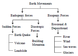
(viii) Various tectonic activities or earth movements are divided on the basis of the forces which cause them to move.
(ix) There are two main types of forces, such as the endogenic forces and the exogenic forces. The forces which originate from the interior of th earth are known as the endogenic forces.
A. Endogenic forces -
(i) The forces which originate from the interior of the earth are known as the endogenic forces.
(ii) These forces cause movements, which give rise to a variety of landforms.
(iii) These forces can be slow or sudden.
(iv) The forces which occur suddenly cause earthquakes and volcanic eruptions.
B. Exogenic forces –
(i) The forces which originate and work on the surface of the earth are known as the exogenic forces.
(ii) These forces can cause widespread destruction through weathering and erosion of existing landforms through different agents like rivers, glaciers, wind, sea waves, etc.
→ INTRODUCTION
(a) Lithospheric Plates
(i)The earth's crust consists of several large and some small, rigid, irregularly – shaped plates (slabs) which carry continents and the ocean floor.
(ii) The crust of the earth, which is also called lithosphere, is broken into a number of big and small plates, which are known as the lithospheric plates.
(iii) These plates float on a semi-molten layer of the asthenosphere below.
(iv) The very slow movement of these plates, say a few millimeters in a year, results in the development of various landforms on the erath's surface.
(v) The surface area of a lithospeheric or tectonic plate is very large in comparison to its thickness. (vi) The movement of the tectonic plates can cause changes on the earth's surface.
(vii) The margins of these plate are very important as most of the tectonic activities, such as volcanoes, earthquakes, faulting, mountains buildings, etc. occur along the margins of the plates.
(viii) Various tectonic activities or earth movements are divided on the basis of the forces which cause them to move.
(ix) There are two main types of forces, such as the endogenic forces and the exogenic forces.
The forces which originate from the interior of th earth are known as the endogenic forces.
A. Endogenic forces -
(i) The forces which originate from the interior of the earth are known as the endogenic forces. (ii) These forces cause movements, which give rise to a variety of landforms.
(iii) These forces can be slow or sudden.
(iv) The forces which occur suddenly cause earthquakes and volcanic eruptions.
B.Exogenic forces –
(i) The forces which originate and work on the surface of the earth are known as the exogenic forces.
(ii) These forces can cause widespread destruction through weathering and erosion of existing landforms through different agents like rivers, glaciers, wind, sea waves, etc.
(b) Type of plates
(i) Actually, the earth's crust is relatively thin and is broken up into a series of plates which fit closely together called lithospheric plates. They are constantly in motion.
(ii) There are seven major lithospheric plates. They are :
→ The African Plate
♦ The Indo – Australian Plate
♦ The Eurasian Plate
♦ The Pacific Plate
♦ The North American Plate
♦ The South American Plate
♦ The Antarctic Plate
(iii) Massive forces inside the earth cause the continents and oceans to move apart and together again, forming larger landmasses and then breaking them part.
(iv) The tremendous heat generated inside the core of the earth cause the rocks in the mantle to become molten. These molten rocks expand, rise and push the plates away from each other. When they cool down, they sink and bring the plates towards each other. This process is known as plate tectonics.
(c) Plate Movement.
There are three types of plate movements. (i)Divergent plate movement occurs when two plates.
(ii) Convergent plate movement occurs when, due to forces of compression, two plates move towards each other and they collide. When two continental plates collide, they form mountains.
(iii) Transform plate movement occurs when two plates slide past each other occur when two plates slide past each other. A tremendous friction occurs which leads to devastating earthquakes.
(d) Formation of Mountains
Mountain building is associated with the movement of the lithospheric plates. When two plates move, it may result in either folding or faulting. These two processes are responsible for the formation of mountains.
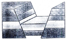
(i)Folding : When two plates collide, a force of compression is created. As a result, the rock layers of the earth's crust get folded. This process is called folding. Alternate upfolds called anticline and downfolds called syncline are formed on the rocks. This is how fold mountains are formed. The Himalyas and the Alps are good examples of fold mountains.
(ii) Faulting : When two plates move apart from each other, a force of tension is created. As a result the crust gets cracked. This process of displacement of rock strata on either sides of the crack creates faults and is called faulting. Block mountains and rift valleys are the most common landforms produced by faulting.
(iii) A Block mountain : Is formed when there are two almost parallel faults and the land between them is either uplifted or left standing after the surrounding areas have subsided. The Sinai Peninsula, the Vosges and the Black Forest in Germany, the Vindhya and the Satpura ranges in India are examples of block mountains. A rift valley is formed when the central block of land between two almost parallel faults, sinks down. The Narmada Valley in India, lying between the Vindhya and the Satpura ranges is also a rift valley.
→ VOLCANOES
A. INTRODUCTION : The sudden movements which originate from within the earth can cause volcanic eruption.
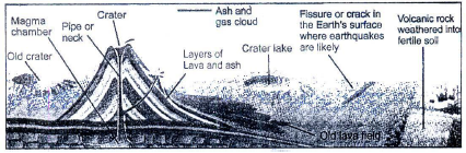
(I) A volcano is a vent or an opening in the earth's crust, through which the hot molten magma erupts suddenly
(2) The magma when reaches the erth's surface, is called lava. (3) The passage through which it travels is called a vent.
(4) The erupted material consists of rock fragments, liquid lava, water, gases, etc.
(5) When the hot liquid magma reaches the surface of the earth, it collects around the vent and begins to cool gradually.
(6) The successive eruption and deposition of lava, form a conical hill. (7) The cones are of various shapes and sizes.
(8) At the mouth of the volcanic vent, a depression is formed which is generally funnel-shaped. It is calledbcrater.
(9) Volcanic eruption may take place either explosively or quietly. An explosive eruption occurs at a point through a narrow vent.The erupted material, accumulates around the vent to form a cone-shaped hill. Mt. Fujiyama in Japan and Mt. Vesuvius in Italy are examples of such volcanoes.
(10) In a quiet eruption lava oozes out through narrow cracks in the earth's crust. It spreads over a large area, forming layers of lava sheets. Some plateaus and plains have been formed in this way. The Deccan Plateau in India and the Colombian Plateau in North America are good examples of this type of formation.
B . TYPES OF VOLCANOES
On the basis of frequency of their eruptions, the volcanoes are of three main types : active, dormant and extinct.
1. The active volcanoes erupt frequently and eject volcanic materials.
(a) The Etna and the Stromboli in Italy are active volcanoes.
(b) There are about 550 active volcanoes in the world.
(c) Most of the active volcanoes are along the margins of Pacific Ocean. This is known as the Pacific Ring of Fire.
2. The dormant volcanoes have not erupted in the recent times, and are regarded as sleeping volcanoes. Mt. Vesuvius in Eruope and Mt. Kilimanjaro in Africa are dormant volcanoes.
3. The extinct volcanoes have not erupted in the known historical period and they are not likely to becomes active again. Mt. Kenya in Africa and Mt. Aconcagua in South America are extinct volcanoes.
C. DISTRIBUTION OF VOLCANOES
(1) Most of the volcanoes occur near the earthquake belts around the young fold mountains.
(2) Volcanoes mostly occur in two major belts – the Circum-Pacific belt and the Midworld Mountain belt.
(3) Most of the active volcanoes and high volcanic cones are found in the Circum-Pacific belt.
(4) The Midworld Mountain belt is not continous and has volcanic zones like the Alps and the Himalayas. (5) The volcanic eruption can cause heavy damage to human life and property.
→ EARTHQUAKES
(1) The teconic forces inside the earth cause vibrations or tremors in the earth's crust. (2) The vibrations are mostly caused by the movement of lithospheric or tectonic plates. (3) These vibrations or shakings can travel all around the earth.
(4) The shaking of the ground due to the sudden tectonic movement is called an earthquake.
(5) The place in the crust of earth from where these sudden movements start is called the focus of the earthquake.
(6) The place which is vertically above the focus on the surface of the earth is called the epicenter.
(7) It is from this point that earthquake waves or seismic waves travel outwards as concentric waves.
→ TYPES OF EARTHQUAKE
The earthquake waves are of three types.
1. The P-waves also called the primary waves or push P-waves are the fastest and are the first to be recorded by the seismograph. In P-waves, the particles move along with the wave and thus cause comparatively less damage.
2. The S-waves also called the secondary waves or shake S-waves are the next to arrive. In S-waves the particle move at right angle to the direction of movement of waves. These waves cannot be transmitted by liquids.
3. The L-waves also called the surface waves or long L-waves, are the last to arrive. The L-waves travel over the surface of the earth and cause maximum damage. These are recorded by the seismograph after the P and S waves.
→ CAUSES OF AN EARTHQUAKE
(1) The earthquakes occur in those regions, where the rock strata is under tremendous strain, caused by the tectonic forces.
(2) Whenever there is a sudden movement of the crustal blocks in the earth's crust, the earthquakes are caused.
(3) The imbalance in the crustal blocks can be due to volcanic eruptions, folding and faulting, plates mvements, expansion of gases and the pressure of water in the man-made reservoirs.
→ MEASUREMENTS OF EARTHQUAKE WAVES
(1) The direction of movement of the earthquake waves and their passage at a particular point is recorded by an instrument called seismograph.
(2) It shows the difference in the arrival of P-waves and S-waves.
(3) This can help us to calculate the distance between the recording station and the epicenter.
(4) Richter Scale is used to measure the power of an earthquake on a scale of 1 to 9. The number indicates the intensity or the magnitude of energy released. Each number on the scale upward from 1 represents 10 times increase in amplitude of shockwaves. The earthquake of less than 4.0 magnitude on Richter Scale is hardly felt, but the one above 6.0 magnitude on the scale may cause severe damage.
→ DISTRIBUTION OF EARTHQUAKE BELTS
The earth experiences more than one million earthquakes every year. Most of the earthquakes are minor and less destructive. There are two main earthquake belts.
E The Circum-Pacific belt : It includes the regions of Rockies and Indus mountains on the western margins and Japan, Philippines, Indonesia, etc. on the eastern margins. This belt experiences about 70 per cent of all earthquakes.
E The Midworld Mountain belt : It stretches from eastern Europe covering the Alphine Himalayan ranges in
Europe and Asia. About 20 per cent of all earthquakes are experienced in this belt. The remaining 10 per cent are associated with Mid-Atlantic Ridge and smaller submarine ridges.
→ PREDICTING EARTHQUAKES
Although it is not possible to predict the arrival of an earthquake, still some people link it to the animal behaviour, such as fishes in the pond get agitated or the snakes come to the surface. The Japanese use the method of measuring changes in sea level to predict earthquakes.
→ PRECAUTIONS DURING AND AFTER THE EARTHQUAKES
1. When you experience the shaking movements, leave the buildings immediately and come to an open area.
2. If trapped inside the building, move to a safer spot, such as under a kitchen counter, table or desk, against an inside corner or wall. Protect your head with your arms.
3. Always keep away from fire places, areas around chimneys, windows, hanging pots, mirrors, bookcases, picture frames etc.
4. If outside the building, keep away from trees, electric or telephone poles, signboards, tall buildings, etc.
5. Public awareness is to be created through programmes for architects, engineers, builders, government officials, house owners, etc.
The Bhuj Earthquake : It was the 51st Republic Day of India. A massive earthquake struck at 8:46 in the morning centered near Bhuj in Gujarat. Its epicenter was in an area called Lodi, 20 k.m. from Bhuj.With a magnitude of 7.9 on the Richter scale, it is one of the two most deadly earthquakes to strike India in its recorded history.
Origin : According to the theory of plate tectonics, most major earthquakes happen along the boundaries of the lithospheric plates. The Bhuj earthquake, however, is an exceptional event. It is considered an intraplate earthquake because it occurred at a great distance from any plate boundary. When two
continental plates collided and began to rub, lots of pressure was created in this area, which was eventually released, creating an earthquake.
Effect : The earthquake was very destructive in terms of lives lost and damage to property. All the destruction occurred in Gujarat and parts of eastern Pakistan. Bhuj was the most devastated town. Considerable destruction also occurred at Bhachau. Ahmedabad, the commercial capital of Gujarat, also suffered extensive damages. More than 30,000 people were killed and at least 1,50, 000 were injured in this earthquake. Over a million structures were damaged or destroyed including several historical monuments in the region, dating from 9th century AD. Electricity transmission lines, phone lines and water pipelines were knocked out, leading to infrastructure failure in the entire region. Total property damage was estimated at 5.5 billion US dollars.
Relief operations : The earthquake triggered off prompt rescue and relief operations. A state of emergency was declared in the earthquake zone by the President. Many voluntary organizations also helped the government which provided aid to the affected families for reconstruction of their houses. People all over the country as well as foreign agencies donated generously for relief and rehabilitation in the affected areas.
Please click on below link to download pdf file for Class 7 Social Science Our Changing Earth A Exam Notes.
Free study material for Social Science
CBSE Class 7 Social Science Our Environment Chapter 3 Our Changing Earth Study Material
Students can find all the important study material for Our Environment Chapter 3 Our Changing Earth on this page. This collection includes detailed notes, Mind Maps for quick revision, and Sure Shot Questions that will come in your CBSE exams. This material has been strictly prepared on the latest 2026 syllabus for Class 7 Social Science. Our expert teachers always suggest you to use these tools daily to make your learning easier and faster.
Our Environment Chapter 3 Our Changing Earth Expert Notes & Solved Exam Questions
Our teachers have used the latest official NCERT book for Class 7 Social Science to prepare these study material. We have included previous year examination questions and also step-by-step solutions to help you understand the marking scheme too. After reading the above chapter notes and solved questions also solve the practice problems and then compare your work with our NCERT solutions for Class 7 Social Science.
Complete Revision for Social Science
To get the best marks in your Class 7 exams you should use Social Science Sample Papers along with these chapter notes. Daily practicing with our online MCQ Tests for Our Environment Chapter 3 Our Changing Earth will also help you improve your speed and accuracy. All the study material provided on studiestoday.com is free and updated regularly to help Class 7 students stay ahead in their studies and feel confident during their school tests.
FAQs
Our advanced study package for Our Environment Chapter 3 Our Changing Earth includes detailed concepts, diagrams, Mind Maps, and explanation of complex topics to ensure Class 7 students learn as per syllabus for 2026 exams.
The Mind Maps provided for Our Environment Chapter 3 Our Changing Earth act as visual anchors which will help faster recall during high-pressure exams.
Yes, teachers use our Class 7 Social Science resources for lesson planning as they are in simple language and have lot of solved examples.
Yes, You can download the complete, mobile-friendly PDF of the Social Science Our Environment Chapter 3 Our Changing Earth advanced resources for free.
Yes, our subject matter experts have updated the Our Environment Chapter 3 Our Changing Earth material to align with the rationalized NCERT textbooks and have removed deleted topics and added new competency-based questions.