
Read and download the CBSE Class 9 Social Science Physical Features of India Assignment for the 2026-27 academic session. We have provided comprehensive Class 9 Geography school assignments that have important solved questions and answers for Contemporary India Chapter 2 Physical Features Of India. These resources have been carefuly prepared by expert teachers as per the latest NCERT, CBSE, and KVS syllabus guidelines.
Solved Assignment for Class 9 Geography Contemporary India Chapter 2 Physical Features Of India
Practicing these Class 9 Geography problems daily is must to improve your conceptual understanding and score better marks in school examinations. These printable assignments are a perfect assessment tool for Contemporary India Chapter 2 Physical Features Of India, covering both basic and advanced level questions to help you get more marks in exams.
Contemporary India Chapter 2 Physical Features Of India Class 9 Solved Questions and Answers
Tectonic Plate Theory:- This theory is based on continental drift which explains the formation of various continents over millions of years; as we see them today.
Plate Boundaries:-Convergent Boundary, Divergent Boundary and Transform Boundary
MAJOR PHYSIOGRAPHIC DIVISIONS:The landmass of India can be divided into following major physiographic divisions:
a.The Himalayan Mountains
b.The Northern Plains
c.The Peninsular Plateau
d. The Indian Desert
e. The Coastal Plains
f. The Islands
Physical Features of India The Himalayan Mountain. The Himalayas run along the northern border of India. The Himalayas form an arc which is about 2,400 km long.
Himalayan Regions from East to West:
a) Punjab Himalayas:- This part lies between the Indus and Sutlej.
b) Kumaon Himalayas: This part lies between Sutlej and Kali rivers.
c) Nepal Himalayas: This part lies between the Kali and Tista rivers.
d) Assam Himalayas: This part lies between the Tista and Dihang rivers.
The Northern Plain :The northern plain of India is formed by three river systems, viz. the Indus, the Ganga and the Brahmaputra; along with their tributaries. This plain is composed of alluvial soil which has been deposited over millions of years. a)Bhabar b) Terai c) Bhangar: d) Khadar:
The peninsular plateau is a tableland. It is composed of the oldest rocks because it was formed from the drifted part of the Gondwana land. The Western and the Eastern Ghats:- They make the western and eastern edges of the Deccan Plateau. The average elevation of Western Ghats is 900 – 1600 metres; compared to 600 metres in case of Eastern Ghats. The Eastern Ghats stretch from Mahanadi Valley to the Nilgiris in the south. The Western Ghats cause orographic rains as they face the rain-laden winds from west. The Indian Desert:-The Indian desert lies towards the western margins of the Aravali Hills. This region gets scanty rainfall which is less than 150 mm in a year.
The Coastal It is divided into three sections. The Konkan; which comprises of Mumbai and Goa makes the northern part. The Kannada Plain makes the central pat and the Malabar coast makes the Malabara coast.The western coastal plain is wider and level and it runs along the Bay of Bengal. It is divided into two parts. The northern part is called Northern Circar. The southern part is called the Coromandel Coast. The IslandsThe Lakshadweep Islands and The Andaman and Nicobar Islands
Location
• India has all major physical features of the Earth, i.e. mountains, plains, deserts, plateaus and islands.
• In India the soil colour varies from place to place as it is formed from different types of rocks.
• India has varied physical features whose formation can be explained on the basis of the ‘Theory of Plate Tectonics’.
• According to the theory of Plate Tectonics the seven major and minor plates that form the Earth’s crust keep moving, causing stress and thus leading to folding, faulting and volcanic activity.
• The physical features of India can be grouped under the following physiographic divisions:
(i) The Himalayan Mountains
(ii) The Northern Plains
(iii) The Peninsular Plateau
(iv) The Indian Desert
(v) The Coastal Plains
(vi) The Islands
The Himalayan Mountains
• The Himalayas are young-fold mountains which are the loftiest and one of the most rugged mountain barriers of the world.
• The Himalayas are 2400 km long, 400 km to 150 km wide from Kashmir to Arunachal Pradesh respectively.
• The Himalayas have three parallel ranges in the longitudinal extent namely:
(i) Great or Inner Himalayas also called Himadri.
(ii) Middle Himalayas or Himachal.
(iii) Outer Himalayas or Shivalik.
• The Himalayas can be divided into four sections:
(i) Punjab Himalayas — between Indus and Satluj.
(ii) Kumaon Himalayas — between Satluj and Kali.
(iii) Nepal Himalayas — between Kali and the Tista.
(iv) Assam Himalayas (Eastern Himalayas) — Between Tista and the Dibang (Tsangpo).
The Northern Plains
• The Northern Plains spread over an area of 7 lakh sq. km, 240 km long and 240 km to 320 km broad.
• The rivers that flow to the plains from the mountains are involved in depositional work.
• Difference in relief causes the Northern Plain to have four regions.
(i) Bhabar — laying at the foot of Shivalik, a narrow 8 to 16 km wide belt of pebbles.
(ii) Terai — lying next to Bhabar, a wet and marshy area with wildlife and forests.
(iii) Bangar — Older alluvium plain which rises above the level of the flood plains.
(iv) Khadar — Younger alluvium of the flood plains.
The Peninsular Plateau
• The Peninsular Plateau is the tableland formed due to the breaking and drifting of the Gondwanaland.
• The plateau consists of two broad divisions, namely, the Central Highlands and the Deccan Plateau.
• The eastward extensions of Peninsular Plateau are locally known as Bundelkhand and Baghelkhand. The Chhota Nagpur Plateau marks the further eastward extension drained by the Damodar river.
• The Deccan Plateau, a triangular mass, lies to the south of the river Narmada.
• The western and eastern edges of the Deccan Plateau are marked by the Western Ghats and the Eastern Ghats respectively.
• The Western Ghats are higher than the Eastern Ghats.
• A distinct feature of the peninsular plateau is the black soil area known as Deccan Trap.
The Indian Desert
• The undulating sandy plain covered with sand dunes towards the western margins of the Aravalli Hills is the Indian Desert.
• Cresent shaped dunes called barchans cover large parts of the Indian Desert.
• Luni is the only large river in this region.
The Coastal Plains
• The narrow coastal strips flank the Peninsular Plateau.
• On the west the coastal strips are divided into Konkan (Mumbai-Goa), Kannad Plain and the Malabar coast from northern to southern part.
• On the east the coastal strip is divided into Northern Circars and the Coromandal Coast from northern to southern part.
The Islands
• The Lakshadweep Islands group in the Arabian Sea is close to Kerala.
• The Lakshadweep Islands were formerly known as Laccadive, Minicoy and Amindive.
• The Andaman and Nicobar Islands are an elongated chain of islands located in the Bay of Bengal.
• The Andamans and Nicobar Islands are an elevated portion of submarine mountains.
Short Type answers
Question 1: What are tectonic plates?
Answer: The crust of the earth is not in the form of a continuous plate rather in the form of broken pieces. These pieces of the earth's crust are called tectonic plates.
Question 2: Which continents of today were part of the Gondwana land?
Answer: South America, Africa, Antarctica, Australia and India were part of the Gondwana land.
Question 3: What is bhabar?
Answer: After descending from the mountains, the rivers deposit pebbles in a narrow belt. The width of this belt is about 8 to 16 km and it lies parallel to the Shiwaliks. This region is known as bhabar. All the streams disappear in this region.
Question 4: Name the three major divisions of the Himalayas from north to south.
Answer: Three major divisions of the Himalayas from north to south are:
- The Great or Inner Himalaya
- The Lesser Himalaya or Himachal
- The Shiwaliks
Question 5: Which plateau lies between the Aravali and the Vindhyan ranges?
Answer: The Malwa plateau lies between the Aravali and the Vindhyan ranges.
Question 6: Name the island group of India having coral origin.
Answer: Lakshadweep
Question 7: Distinguish between
a. Converging and diverging tectonic plates
Answer: The converging tectonic plates move towards each other, while diverging plates move away from each other.
b. Bhangar and Khadar
Answer: Bhangar is the largest part of the Northern Plains and is formed by the oldest alluvium. On the other hand, Khadar is the younger deposit of alluvium.
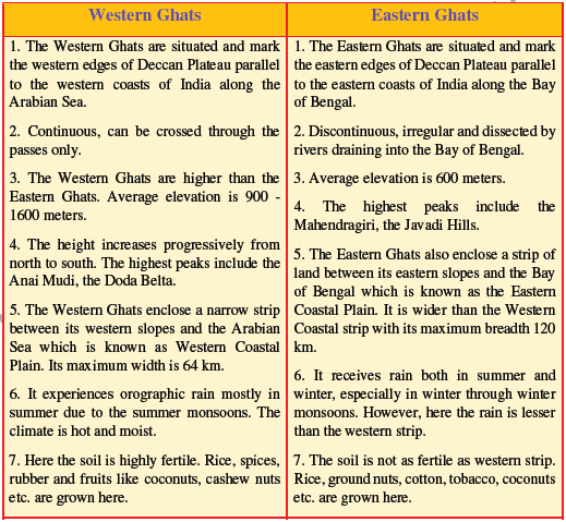
c. Western Ghats and Eastern Ghats
Answer:
Western Ghats Eastern Ghats
They lie along the Arabian Sea. They lie along the Bay of Bengal.
Average height is 900 to 1600 m Average height is 600 m
They are almost continuous. They are interspersed by rivers.
Question 8: Describe how the Himalayas were formed.
Answer: The Indian Peninsula drifted towards the north and finally collided with the much larger Eurasian Plate. As a result of this collision, the sedimentary rocks which were
accumulated in the geosynclines (known as Tethys) got folded and formed the mountai systems of the West Asia and Himalaya.
Question 9: Which are the major physiographical divisions of India?
Contrast the relief of the Himalayan region with that of the Northern Plains of India.
Answer: The landmass of India can be divided into following major physiographic divisions:
a. The Himalayan Mountains
b. The Northern Plains
c. The Peninsular Plateau
d. The Indian Desert
e. The Coastal Plains
f. The Islands
The Himalayan region is rugged and shows great variations in terms altitude. The Northern Plains, on the other hand, is more or less level and has least variations in terms of altitude. The Himalayan region is formed by rocks and unconsolidated sediments. The Northern Plains is composed of alluvial deposits.
Question 10: Write short notes on the following:
a. The Indian Desert
Answer: The Indian desert lies towards the western margins of the Aravali Hills.This region gets scanty rainfall which is less than 150 mm in a year. Hence the climate is arid and vegetation is scanty. Luni is the only large river but some streams appear during rainy season. Crescent-shaped dunes (barchans) abound in this area.
b. The Central Highlands
Answer: The Central Highlands lies to the north of the Narmada river. It covers the major portion of the Malwa plateau. The rivers in this region flow from southwest to northeast; which indicates the slope of this region. It is wider in the west and narrower in the east. Bundelkhand and Baghelkhand mark the eastward extension of this plateau. The plateau further extends eastwards into the Chhotanagpur plateau.
Question.Explain the Himalayan mountains under the following headings:
Answer: i) Extent of the range ii) Shape iii) Length iv) Width v) Altitudinal
variations. i) Extent of the range: These mountain ranges run in a west-east direction from the Indus to the Brahmaputra. ii) Shape : form an arc iii) Length: 2,400 Km. iv) Width: Their width varies from 400 Km in Kashmir to 150 Km in Arunachal Pradesh. v) Altitudinal variations: The altitudinal variations are greater in the eastern half than those in the western half.
Question. Explain Himadri range under the following headings:
Answer: 1) Other name : the Great or Inner Himalayas
2) Location : The northern most range
3) Average altitude: an average height of 6,000 metres.
4) Prominent peaks : Mt. Everest Nepal 8848 ,Kanchenjunga India 8598,Makalu Nepal 8481,Dhaulagiri Nepal 8172
5) Folds: asymmetrical in nature.
6) Core of this part: composed of granite.
Question. Explain the characteristics of the Himachal under the following headings:
Answer: i) Location : lies to the south of the Himadri ii) Other name : Himachal or lesser Himalaya.
iii) Rocks: compressed and altered rocks. iv) Altitude: between 3,700 and 4,500 metres v) Average width: width is of 50 Km. vi) Important ranges : Pir Panjal ,Dhaula Dhar &Mahabharat vii) Famous valleys: the Kashmir ,Kangra &Kullu valley viii) Hill Stations: Mussoori ,Nainital & Ranikhet.
Question. Answer the following questions briefly:
(i) What are tectonic plates?
(ii) Which continents of today were parts of the Gondwana land?
(iii) What is bhabar?
(iv) Name the three major divisions of the Himalayas from north to south.
(v) Which plateau lies between the Aravali and the Vindhyan ranges?
(vi) Name the island group of India having coral origin.
Answer:
(i) Large fragments of the Earth’s crust torn due to the rising currents are called tectonic plates.
(ii) South America, part of Africa (south Africa including Madagascar), part of Asia (India,Arabia, Malaya), Australia and Antarctica continents were parts of the Gondwana land.
(iii) The Bhabar is that narrow belt of the plain which is covered with pebbles and lies along the foothills of the Shiwaliks from the Indus to the Teesta.
(iv) The Great or the Inner Himalayas or the Himadri, the Middle Himalayas or the Himachal, and the Outer Himalayas or the Shivaliks.
(v) The Malwa plateau lies between the Aravali and the Vindhya Ranges.
(vi) Lakshadweep Islands is the island group of India having coral origin.
Question. Distinguish between
(i) Converging and Diverging Tectonic Plates.
(ii) Bhangar and Khadar
(iii) Western Ghats and Eastern Ghats
Answer:
| Converging Tectonic Plates | Diverging Tectonic Plates |
| When tectonic plates move towards each other, they are called converging plates. | When tectonic plates move away from each other, they are called diverging plates. |
| They collide or crumble or one of them slides under the other while moving towards each other. | They do not collide or crumble while moving away from each other. |
| Converging plates cause folds. | Diverging plates cause fractures in the crust. |
| Bhangar | Khadar |
| These are the older alluvium or old soil and form the largest part of the Northern Plains. | The newer and younger deposits of the flood plains. Renewed every Year. |
| Lies above flood plains of rivers. | Is newer, younger deposit of flood |
| Presents a terrace like feature. | Contains calcerous deposits locally known as Kankar. |
| Less fertile | More fertile |
Question. Describe how the Himalayas were formed.
Answer: According to the Theory of Plate Tectonics, the Earth's crust was initially a single, giant supercontinent called Pangea. Its northern part was the Angara land and the southern part was the Gondwana land. The convectional currents split the crust into a number of pieces, thus leading to the drifting of the Indo-Australian plate after being separated from the Gondwana land, towards north. The northward drift resulted in the collision of the plate with the much larger Eurasian Plate. Due to this collision, the sedimentary rocks which were accumulated in the geosyncline known as theTethys were folded to form the mountain system of western Asia and Himalaya.
Question. Which are the major physiographic divisions of India? Contrast the relief of the Himalayan region with that of the Peninsular Plateau.
Answer: The major physiography divisions of India are :
(i) The Himalayan Mountains
(ii) The Northern Plains
(iii) The Peninsular Plateau
(iv) The Indian Desert
(v) The Coastal Plains
(vi) The Islands
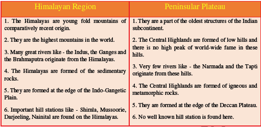
| The Himalayan Region | The Peninsular Plateau |
| Young fold mountains made from the uplift of the strata formed by the sedimentary rocks. | Created from igneous and metamorphic rocks after splitting of Gondwanaland. |
| Consists of the loftiest mountains and deep valleys The ranges have V-shaped and U-shaped valleys. | Consists of broad and shallow valleys, and rounded hills It has horsts, rift valleys and troughs. |
| It is the origin of perennial rivers. | It has rainfed, seasonal rivers. |
| From the point of view of geology, this region forms an unstable zone | This region forms a stable zone |
Question. Give an account of the Northern Plains of India.
Answer:The Northern Plains have been formed from the alluvium that the mountain rivers deposited here. This turned the soil on the surfaced land fertile for growing a rich harvest of variety of crops. This led to the development of the Indus River Valley Civilisation. The rich soil was further aided by favourable climate and constant water supply from the rivers. Between the mouths of the Indus and the Ganga-Brahmaputra, the North Indian Plain covers a distance of 3200 km. It is 300 to 150 km wide at some places. The North Indian Plains have the Indus river system in the west and the Ganga-Brahmaputra river system in the east. The first includes Jhelum, Chenab, Ravi, Beas, Satluj. The Indus flows into the Arabian Sea. The second includes Ganga, its tributaries and the Brahmaputra which combine as Meghna as they drain into the Bay of Bengal. They form the world’s largest and fastest growing delta. The difference in relief has led the North Indian Plains to be divided into four zones : (i) Bhabhar, (ii) Tarai, (iii) Bangar and (iv) Khadar.
Question. Write short notes on the following.
(i) The Indian Desert
(ii) The Central Highlands
(iii) The Island groups of India
Answer
(i) The Indian desert lies towards the western margins of the Aravali Hills. It is an undulating sandy plain covered with sand dunes called barchans. This region receives very low rainfall below 150 mm per year (15 cm) . It has arid climate with low vegetation cover. Streams appear during the rainy season. Soon after they disappear into the sand as they do not have enough water to reach the sea. Luni is the only large river in this region.
(ii) The part of the peninsular plateau lying to the north of the Narmada River covering a major area of the Malwa plateau is known as the Central Highlands. The Vindhyan range is bounded by the Central Highlands on the south and the Aravali range on the northwest. The flow of the rivers draining this region, namely the Chambal, the Sind, the Betwa and Ken is from southwest to northeast, thus indicating the slope. The Central Highlands are wider in the west but narrower in the east. The eastward extensions of this plateau are locally known as the Bundelkhand and Baghelkhand. The Chotanagpur plateau marks the further eastward extension, drained by the Damodar River.
(iii) India has 2 main island groups, namely Lakshadweep and Andaman and Nicobar island.The Lakshadweep consists of many small islands located opposite the Kerala coast in the Arabian Sea. The islands of this group are formed of coral deposits called ‘atolls’ in Malayalam which refer to their ring or ‘horse-shoe’ shape. The Andaman and Nicobar Islands, on the other hand, are larger in size. They are more in number and more widely scattered.
There are about 200 islands in the Andaman group and 19 islands in the Nicobar group.
Question : Choose the right answer from the four alternatives given below.
(i) A landmass bounded by sea on three sides is referred to as
(a) Coast
(b) Peninsula
(c) Island
(d) None of the above
Answer: (b) Peninsula
(b) Purvachal
(d) None of the above
(b) Kannad
(d) Northern Circar
(b) Mahendragiri
(d) Khasi
Free study material for Social Science
CBSE Class 9 Geography Contemporary India Chapter 2 Physical Features Of India Assignment
Access the latest Contemporary India Chapter 2 Physical Features Of India assignments designed as per the current CBSE syllabus for Class 9. We have included all question types, including MCQs, short answer questions, and long-form problems relating to Contemporary India Chapter 2 Physical Features Of India. You can easily download these assignments in PDF format for free. Our expert teachers have carefully looked at previous year exam patterns and have made sure that these questions help you prepare properly for your upcoming school tests.
Benefits of solving Assignments for Contemporary India Chapter 2 Physical Features Of India
Practicing these Class 9 Geography assignments has many advantages for you:
- Better Exam Scores: Regular practice will help you to understand Contemporary India Chapter 2 Physical Features Of India properly and you will be able to answer exam questions correctly.
- Latest Exam Pattern: All questions are aligned as per the latest CBSE sample papers and marking schemes.
- Huge Variety of Questions: These Contemporary India Chapter 2 Physical Features Of India sets include Case Studies, objective questions, and various descriptive problems with answers.
- Time Management: Solving these Contemporary India Chapter 2 Physical Features Of India test papers daily will improve your speed and accuracy.
How to solve Geography Contemporary India Chapter 2 Physical Features Of India Assignments effectively?
- Read the Chapter First: Start with the NCERT book for Class 9 Geography before attempting the assignment.
- Self-Assessment: Try solving the Contemporary India Chapter 2 Physical Features Of India questions by yourself and then check the solutions provided by us.
- Use Supporting Material: Refer to our Revision Notes and Class 9 worksheets if you get stuck on any topic.
- Track Mistakes: Maintain a notebook for tricky concepts and revise them using our online MCQ tests.
Best Practices for Class 9 Geography Preparation
For the best results, solve one assignment for Contemporary India Chapter 2 Physical Features Of India on daily basis. Using a timer while practicing will further improve your problem-solving skills and prepare you for the actual CBSE exam.
FAQs
You can download free PDF assignments for Class 9 Geography Contemporary India Chapter 2 Physical Features Of India from StudiesToday.com. These practice sheets have been updated for the 2026-27 session covering all concepts from latest NCERT textbook.
Yes, our teachers have given solutions for all questions in the Class 9 Geography Contemporary India Chapter 2 Physical Features Of India assignments. This will help you to understand step-by-step methodology to get full marks in school tests and exams.
Yes. These assignments are designed as per the latest CBSE syllabus for 2026. We have included huge variety of question formats such as MCQs, Case-study based questions and important diagram-based problems found in Contemporary India Chapter 2 Physical Features Of India.
Practicing topicw wise assignments will help Class 9 students understand every sub-topic of Contemporary India Chapter 2 Physical Features Of India. Daily practice will improve speed, accuracy and answering competency-based questions.
Yes, all printable assignments for Class 9 Geography Contemporary India Chapter 2 Physical Features Of India are available for free download in mobile-friendly PDF format.