
Read and download the CBSE Class 9 Social Science Climate Assignment Set 01 for the 2026-27 academic session. We have provided comprehensive Class 9 Geography school assignments that have important solved questions and answers for Contemporary India Chapter 4 Climate. These resources have been carefuly prepared by expert teachers as per the latest NCERT, CBSE, and KVS syllabus guidelines.
Solved Assignment for Class 9 Geography Contemporary India Chapter 4 Climate
Practicing these Class 9 Geography problems daily is must to improve your conceptual understanding and score better marks in school examinations. These printable assignments are a perfect assessment tool for Contemporary India Chapter 4 Climate, covering both basic and advanced level questions to help you get more marks in exams.
Contemporary India Chapter 4 Climate Class 9 Solved Questions and Answers
CLIMATE
Climate refers to the sum total of weather conditions and variations over a large area for a long period of time.
It is the sum total of weather conditions for larger area. Eg: for a country:
WEATHER:
It refers to state of atmosphere over an area at any point of time.
It is the total of weather conditions for limited area. Eg: for a city The elements of weather and climate are temperature, atmospheric pressure, wind, humidity and precipitation.
INDIAN CLIMATE
• The climate of India is monsoon type.
• Monsoon is derived from „mausim‟ which means season and it refers to the seasonal reversal in the wind direction during a year.
• In Asia, this type of climate is found mainly in south and south-east.
CLIMATIC CONTROLS
The major controls of climate are:
1. Latitude : Due to curvature the amount of solar energy received varies according to it.
2. Altitude: As we go higher there is a decrease in temperature of 16‟
3.Pressure and Wind system: As per latitude and altitude temperature and rainfall also influences the climate.
4. Distance from sea: The sea exerts moderating influence on climate, regions near sea experiences moderate climate.
5. Ocean Currents: It leads continentality which means very hot during summers and very cold during winters.
The unifying influence of the monsoon on the Indian subcontinent is quite perceptible. The seasonal alteration of the wind systems and the associated weather conditions provide a rhythmic cycle of seasons. Even the uncertainties of rain and uneven distribution are very much typical of the monsoon.
The Indian landscape, its animal and plant life, the people, including their festivities, revolve around this phenomenon. Year after year, people of India from north to south and from east to west, eagerly await the arrival of the monsoon. These monsoon winds bind the whole country by providing water to set the agricultural activities in motion.
The river valleys which carry this water also unite as a single river valley unit. Early in the season, the windward side of the Western Ghats receives very heavy rainfall, more than 250cm. The Deccan Plateau and parts of Madhya Pradesh also receive some amount of rain in spite of lying in the rain shadow area. The maximum rainfall of this season is received in the north-eastern part of the country.
Rainfall in the Ganga valley decreases from the east to the west. Rajasthan and parts of Gujarat get scanty rainfall. The breaks in the monsoon are related to the movement of the monsoon tough. The trough and its axis keep on moving northward or southward. When the axis of the monsoon trough lies over the plains and widespread rain occur in the Himalayan Rivers. Mawsynram in the southern ranges of the Khasi Hills receives the highest average rainfall in the world.
Why is monsoon known for its “uncertainties”? While it causes heavy floods in one part, it may be responsible for droughts in the other.It is often irregular in its arrival and its retreat. Hence, it sometimes disturbs the farming schedule of millions of farmers all over the country.Owing to the conditions of high temperature and humidity, the weather becomes rather oppressive during the day. This is known as “OCTOBER HEAT”. The low-pressure conditions, over north-western India, get transferred to the Bay of Bengal by early November. This shift is associated with the occurrence of cyclonic depressions, which originates over the Andaman Sea.These cyclones generally cross the eastern coasts of India cause heavy and widesprad rain. These tropical cyclones are often very destructive. The thickly populated deltas of the Godavari, the Krishna and the Kaveri are frequently struck by cyclones, which cause great damage to life and property.
THE SEASONS
The monsoon type of climate is characterised by a distinct seasonal pattern. The weather conditions greatly change from one season to the other. The coastal areas do not experience much variation in temperature though there is variation in rainfall pattern. Four main seasons can be identified in India- the cold weather season, hot weather season, the advancing monsoon and the retreating monsoon with some regional variations.
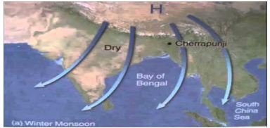
THE COLD WEATHER SEASON (WINTER)
1. The cold weather season begins from mid- November in northern India and stays till February.
2. December and January are the coldest months in the northern part of India.
3. The temperature decreases from south to the north.
4. Days are warm and nights are cold.
5. Frost is common in the north and the higher slopes of Himalayas experience snowfall.
6. The Northeast trade winds blow from land to sea and hence, for most part of the country, it is a dry season.
7. Some amount of rainfall occurs on the Tamil Nadu coast from these winds as, here they blow from sea to land.
8. The weather is normally marked by clear sky, low temperatures and low humidity and feeble variable winds.
9. A characteristic feature of the cold weather season over the northern plains is a the inflow of cyclonic disturbances from the west and the northwest.
10.They cause the much- needed winter rains over the plains and snowfall in the mountains.
11. Total amount of winter rainfall locally known as „mahawat‟ is small; they are of Immense importance for the cultivation of „rabi‟ crops.
12. The peninsular region does not have well- defined cold season.
THE HOT WEATHER SEASON (SUMMER)
1. From March to May, it is hot weather season in India.
2. The influence of shifting of the heat belt can be seen clearly from temperature recordings taken during March- May at different latitudes.
3. In peninsular India, temperature remain lower due to the moderating influence of the oceans.
4.The summer months experience rising temperature and falling air pressure in the northern part of the country.
5. Towards the end of May, an elongated low pressure area develops in the region extending from the Thar Desert in the northwest to Patna and Chotanagpur plateau and southeast.
6. The striking feature of the hot weather season is the „loo‟. These are strong, gusty, hot, dry winds blowing during the day over the north and northwestern India.
7. Dust storms are very common during the month of May in northern India. These storms bring temporary relief as they lower the temperature and may bring light rain and cool breeze.
8. In West Bengal, these storms are known as „Kaal Baisakhi‟.
9. Towards the close of the summer season, pre- monsoon showers are common especially, in Kerala and Karnataka.
DISTRIBUTION OF RAINFALL
There are three types of rainfall :- -Low rainfall (Less than 50 cm.) - Average rainfall (Between 50 to 250 cm.) - High rainfall (More than 250 cm.)
1. Parts of western coast and northern India receive over about 400 cm of rainfall annually.
2. It is less than 60cm in western Rajasthan and adjoining parts of Gujarat, Haryana and Punjab.
3. Rainfall is equally low in the interior of Deccan plateau and east of the Sahyadris.
4. The rest of the country receives moderate rainfall. Snowfall is restricted to the Himalayan region. Because of the nature of monsoons, the annual rainfall is highly variable from year to year. Variability is high in the regions of low rainfall such as parts of Rajasthan, Gujarat and leeward (rain shadow area) side of the Western Ghats. While the areas of high rainfall are responsible to be affected by the floods and the areas of low rainfall are drought- prone. SOME IMPORTANT TERMS
1. Frost- A state in freezing, frozen dew.
2. Loo- Strong, gusty, hot, dry winds blowing during the day over the north and northwestern India.
3. Mango showers- Pre-monsoon showers in Kerala and Karnataka help in ripening of mangoes earlier, known as monsoon showers.
4. Trough- large vacuum in between of the Himalayas and the peninsular plateau, the plains.
5. Leeward- Rain shadow area.
Question. Name the elements of
a) Weather
b) Climate

Answer. The elements of weather and climate are the same, i.e. temperature, atmospheric pressure, wind, humidity and precipitation.
Question. Define the terms: Weather and Climate
Answer.
1. Climate refers to the sum total of weather conditions and variations over a 2large area for a long period of time (more than thirty years).
2. Weather refers to the state of the atmosphere over an area at any point of time.
Question. Describe the regional variations in temperature conditions as observed in various parts of India.
Answer.
a) In summer, the mercury occasionally touches 50°C in some parts of the Rajasthan desert, whereas it may be around 20°C in Pahalgam in Jammu and Kashmir.
b) On a winter night, temperature at Drass in Jammu and Kashmir may be as low as minus 45°C.
c) Thiruvananthapuram, on the other hand, may have a temperature of 20°C.
d) In the Thar Desert the day temperature may rise to 50°C, and drop down to near 15°C the same night.
e) On the other hand, there is hardly any difference in day and night temperatures in the Andaman and Nicobar islands or in Kerala.

Question. Describe the variations in the form, type, amount and seasonal distribution of rainfall as observed in various parts of India.
Answer. 1. While precipitation is mostly in the form of snowfall in the upper parts of Himalayas, it rains over the rest of the country.
2. The annual precipitation varies from over 400 cm in Meghalaya to less than 10 cm in Ladakh and western Rajasthan.
3. Most parts of the country receive rainfall from June to September.
4. But some parts like the Tamil Nadu coast get most of its rain during October and November.
Question. Describe how latitude and altitude are important factors in determining the climate of India.
Answer.
LATITUDE: Due to the curvature of the earth, the amount of solar energy received varies according to latitude. As a result, air temperature decreases from the equator towards the poles.
ALTITUDE: As one goes from the surface of the earth to higher altitudes, the atmosphere becomes less dense and temperature decreases. The hills are therefore cooler during summers.
Question. Give an account of the Cold weather season in India on the basis of:
Answer. 1. Period/ Duration:
Begins in mid-November till February (1mk)
2. Temperature conditions:
a) December and Jan are the coldest months in the northern part of India. The temperature in the northern plains ranges between 10ºC to 15ºC.
b) The temperature decreases from south to the north. The average temperature of Chennai is between 24ºC to 25ºC.
3. Pressure and Wind conditions:
I) In northern part of the country, a feeble high-pressure region develops, with light winds moving outwards from this area.
II) Influenced by the relief, these winds blow through the Ganga valley from the west and northwest.
III) During this season northeast trade winds prevail over the country. They blow from land to sea hence for most part of the country it is a dry season.
4. Precipitation:
A) Frost is common in the north and the higher slopes of the Himalayas experience snowfall.
B) Some amount of rainfall occurs on the Tamil Nadu coast from these winds as here they blow from sea to land.
C) Western Disturbances cause winter rains over the plains and snowfall in the mountains.
5. Weather:
a) In the northern plains, days are warm and nights are cold.
b) The weather is normally marked by clear sky, low temperatures and low humidity and feeble variable winds.
6. Effects of the cold season over the Peninsula:
I) The peninsular region does not have a well defined cold season.
II) There is hardly any noticeable seasonal change in temperature pattern during winters due to the moderating influence of the sea.
Question. Give an account of hot weather season in India on the basis of:
Answer. 1. Duration: The hot weather season extends from March to May.
2. Temperature conditions:
1. In March, the highest temperature is about 38ºC recorded on Deccan plateau.
2. In April, temperatures in Gujarat and Madhya Pradesh are around 42ºC.
3. In May, temperature of 45ºC is common in the North- western part of the country.
4. In peninsular India, temperatures remain lower due to the moderating influence of the oceans.
3. Pressure conditions:
4. In summer months experience rising temperature and falling air pressure in the northern part of the country.
5. Towards the end of May, an elongated low-pressure area develops in the region extending from the Thar Desert in the northwest to Patna and Chotanagpur plateau in the east and southeast.
Question. a) What is meant by Loo?
Answer. A striking feature of the hot weather season is the Loo. These are strong, gusty, hot, dry winds blowing during the day over the north and northwestern India. Sometimes they even blow during the evening.
b) State the main effect of loo.
3. Direct exposure to these may even prove fatal.
Question. What is the effect of the dust storms over northern India?
Answer.1. Dust storms are very common during the month of May in Northern India.
2. These storms bring temporary relief as they lower the temperature and may bring light rain and cool breeze.
Question. What are “Kaal Baisakhi” winds?
Answer.1. This is also the season for localized thunderstorms, associated with violent winds, torrential downpours, accompanied by hail.
2. In West Bengal, these storms are known as the “Kaal Baisakhi” calamity for the month of Baisakh.
Question. Briefly describe the phenomena of “mango showers”?
Answer. 1. Towards the close of the summer season, pre-monsoon showers are common especially in Kerala and Karnataka.
2. They help in the ripening of mangoes, and are often referred to as “mango showers”.
Question. Name the four months in which India receives its bulk of the rainfall.
Answer. June, July, August, September
Question. What is meant by “Breaking of the Monsoons”?
Answer.1. Another phenomenon associated with the monsoon is its tendency to have „breaks‟ in rainfall. It has wet and dry spells.
2. In other words, the monsoon rains take place only for a few days at a time. They are interspersed with rainless intervals. These breaks in monsoon are related to the movement of the monsoon trough.
Question. a) Mention the two main branches of the South West Monsoon.
Answer. 1) Arabian Sea Branch
2) Bay of Bengal Branch.
b) What makes these two branches to divide into two parts?
¶ The presence of the tip of the Indian peninsula divides the south west monsoon into Arabian Sea branch and Bay of Bengal branch.
Question. The bulk of rainfall in India is concentrated over a few months. Give reasons.
Answer.
¶ By early June, the low-pressure condition over the northern plains intensifies. It attracts the trade winds of the southern hemisphere.
¶ These south-east trade winds originate over the warm subtropical areas of the southern oceans.
¶ They cross the equator and blow in a south westerly direction entering the Indian peninsula as the south-west monsoon.
¶ As these winds blow over warm oceans, they bring abundant moisture to the subcontinent. This condition occurs from June to September; hence bulk of rainfall is concentrated over a few months only.
Question. Why do the south- westerly winds cause rain in India?
Answer.
¶ The south-east trade winds cross the equator and blow in a south westerly direction entering the Indian peninsula as the south –west monsoon.
¶ As these winds blow over warm oceans, they bring abundant moisture to the subcontinent.
Question. Parts of Rajasthan, Gujarat and the leeward side of the Western Ghats are drought prone. Give reasons.
Answer. Parts of Gujarat:
¶ The Arabian Sea branch of the Indian monsoon enters Gujarat after advancing from the Deccan plateau.
¶ Due to distance from the sea, the winds lose moisture and hence the interior part of Gujarat do not receive adequate rainfall.
¶ There is no windward effect due to absence of any prominent relief feature.
Rajasthan:
1. The Arabian Sea branch of the Indian monsoon blows parallel to the Aravallis after advancing into Rajasthan from Gujarat.
2. The winds blow from the south-west to the north-east and so is the location of the Aravallis. The winds are not able to cross over the mountains
3. Rajasthan desert is located on the leeward side of the Aravellis and hence the winds give less rainfall.
4. Thus, distance from the sea and the leeward effects are responsible for scanty rainfall in this region.
Leeward side of the Western Ghats:
1. The south-east trade winds after crossing the equator blow as south-west trade winds due to Coriolis effect.
2. The south-east monsoon winds collect moisture from the Arabian sea and strike the Western Ghats.
3. As the winds rise up the slope, condensation and then heavy rainfall results on the windward slope of the Western Ghats.
4. The winds cross over, lose moisture and this results in less rainfall on the leeward slope of the Western Ghats.
Question. How does Western Himalayas get rainfall during the time of the advancing monsoon seasons?
Answer.
a) Whenever the axis of the monsoon trough shifts closer to the Himalayas, rainfall is good in the mountainous catchment areas of the Himalayan rivers.
b) The Western Himalayan region also gets the influence of the Arabian Sea branch, which brings in less moisture and causes less rainfall in the windward side of the mountains.
c) As this region is far away from the influence of the sea the amount of rainfall is less compared to the other parts of the Himalayas.
Question. How does the Bay of Bengal branch of the Indian Monsoon split into two parts?
Answer.
1. The Bay of Bengal branch comes with a high moisture content and hits the Eastern Himalayas (Purvanchals) and causes heavy rainfall in these areas.
2. The other part of the Bay of Bengal branch gets diverted by the presence of the Himalayas and move over the Ganga valley region causing rainfall.
Question. Which place in India records the highest rainfall in the world?
Answer. Mawsynram receives the highest rainfall in the world.
Question. Mawsynram receives the highest rainfall in the world. Give reasons. l branch of the Indian Monsoon strikes the Purvanchals after crossing the Bengal coast.
1. Mawsynram is located on the southern crest of the Khasi hills which is the windward side.
2. It is located in a funnel-shaped valley which draws in the monsoon winds resulting in very heavy rainfall.
Question. Why does the rainfall decreases from east to west in the Ganga valley?
Answer.
a) The Bay of Bengal branch of the Indian Monsoon enters from the Bengal coast and strikes the Purvanchals.
b) The winds get deflected due to the topography (Himalayas to the north and Peninsular plateau to the south) and start moving up the Ganga plain.
c) The amount of rainfall decreases up the Ganga valley from Kolkata to Delhi.
d) Hence as we move away from the sea coast, the factor of distance from the sea operates (winds lose moisture as they move away from the coast) and rainfall decreases from the east to the west.
Question. Give example to show that the monsoons are known for their uncertainties and vagaries.
Answer.
1. The alternation of dry and wet spells vary in intensity frequency and duration.
2. While it causes heavy floods in one part it may be responsible for droughts in the other.
3. It is often irregular in its arrival and its retreat. Hence, it sometimes disturbs the farming schedule of millions of farmers all over the country.
Question. What are retreating monsoons?
Answer.
1. During October-November, with the apparent movement of the sun towards the south, the monsoon trough or the low pressure trough over the northern plains becomes weaker.
2. The south west monsoon winds weaken and start withdrawing gradually. By the beginning of October, the monsoon withdraws from the northern plains and blows towards the sea.
Question. Briefly describe the phenomenon of October Heat.
Answer.
1. The retreat of the monsoon is marked by clear skies and rise in temperature.
2. While day temperatures are high, nights are cool and pleasant. The land is still moist.
3. Owing to the conditions of high temperature and humidity, the weather becomes rather oppressive during the day. This is commonly known as “October Heat”.
Question. The deltas of Godavari, Krishna and Kaveri are frequently struck by cyclones. Give reasons.
Answer.
1. The low pressure conditions over north- western India get transformed to the Bay of Bengal by early November with the occurrence of cyclonic depressions which originate over the Andaman Sea.
2. These cyclones generally cross the eastern costs of India causing heavy and widespread rain and are also destructive.
3. The thickly populated deltas of the Godavari, Krishna and the Kaveri are frequently struck by cyclones which cause great damage to life and property.

Question. Discuss the distribution of precipitation in the country and the consequences of its uneven distribution.
Answer.
1. Parts of western coast and north eastern India receive over about 400cm of rainfall annually.
2. It is less than 60 cm in western Rajasthan and adjoining parts of Gujarat, Haryana, and Punjab.
3. Rainfall is equally low in the interior of the Deccan plateau and the east of Sahyadris.
4. Low precipitation is around Leh in Jammu and Kashmir. Rest of the country receives moderate rainfall.
Question. Explain how monsoons act as a unifying bond in our country.
Answer.
1. The seasonal alteration of the wind systems and the associated weather conditions provide a rhythmic cycle of seasons.
2. Even the uncertainties of rain and uneven distribution are very much typical of the monsoons.
3. The Indian landscape, its animal and plant life, its entire agricultural calendar and the life of the people, including their festivities, revolve around this phenomenon.
4. These monsoon winds bind the whole country by providing water to set the agricultural activities in motion.
5. The river valleys which carry this water also unite as a single river valley unit
Choose the correct answer from the four alternatives given below.
Question : What are the major controls of the climate? Explain them.
Answer: The six major controls of the climate are latitude, altitude, pressure and wind system, distance from the sea, ocean currents and relief features.
• Due to the shape of the earth, the amount of solar energy received varies according to latitude. As a result, air temperature generally decreases from the equator towards the poles, as one goes from the surface of the earth to higher altitudes.
• On going from the earth’s surface to higher altitudes, the atmosphere becomes less dense and temperature decreases. The hills are, therefore, cooler during summers.
• The pressure and wind system of any area depends on the latitude and altitude of the place. Thus, it influences the temperature and rainfall pattern. The sea exerts a moderating influence on climate.
• As the distance from the sea increases, its moderating influence decreases and the people experience extreme weather conditions. This condition is known as continentality (i.e., very hot during summers and very cold during winters).
• Ocean currents along with onshore winds affect the climate of the coastal areas. For example, any coastal area with warm or cold currents flowing past it, will be warmed or cooled if the winds are onshore.
• Relief too plays a major role in determining the climate of the place. High mountains act as barriers for cold or hot winds; they may also cause precipitation it they are high enough and lie in the path of rain-bearing winds. The leeward side of mountains remains relatively dry. (Any four points)
Question : Give a brief account of the hot weather season in India.
Answer: The period between March to May is the hot weather season or summer in India. The characteristic features of the hot weather season are as follows :
• Due to the apparent northward movement of the sun, the global heat belt shifts northwards.
Question : What are the variations in precipitation in India?
Answer: (a) There are variations not only in the form and types of precipitation but also in its amount and the seasonal distribution.
(b) The rest of the country receives moderate rainfall. Snowfall is restricted to the Himalayan region.
(c) The annual precipitation varies from over 400 cm in Meghalaya to less than 10 cm in Ladakh and western Rajasthan.
(d) Owing to the nature of monsoons, the annual rainfall is highly variable from year to year. Variability is high in the regions of low rainfall, such as parts of Rajasthan, Gujarat and the leeward side of the Western Ghats.
(e) Most parts of the country receive rainfall from June to September but some parts like the Tamil Nadu coast gets most of its rains during October and November.
Question : Describe the effect of western cyclonic disturbances on the Indian climate?
Answer: The western cyclonic disturbances are weather phenomena of the winter months brought in by the westerly flow from the Mediterranean region. They affect the climate of India in the following ways :
• By causing cyclonic rainfall in the month of winter, which is otherwise dry, the region of western cyclonic disturbances influence the weather of the north and north-western India.
• These low-pressure systems originate over the Mediterranean Sea and Western Asia and move into India, alongwith easterly flow.
• They cause the much-needed winter rains over the plains and snowfall in the mountains.
• Although the total amount of winter rainfall, locally known as ‘Mahawat’ is small, it is very useful for rabi crops. These winds are called western cyclonic disturbances since they came from the western part of India.
Question : Write about the Arabian Sea branch of the monsoon.
Answer:The monsoon arrives at the southern tip of the Indian peninsula generally by the first week of June. Subsequently, it proceeds into two – the Arabian Sea branch and the Bay of Bengal branch. The Arabian Sea branch reaches Mumbai about ten days later on approximately the 10th of June. This is a fairly rapid advance. The onshore moisture-laden winds strike the Western Ghats and provide heavy rainfall on its windward side. As a result, Mumbai in the windward side receives much more rainfall than Pune which is located on the leeward side of the Western Ghats.
By mid-June, the Arabian Sea branch of the monsoon arrives over Saurashtra-Kuchchh and the central part of the country. In the western and north-western parts of the country, the highlands, the Aravalli, lie parallel to the direction of the incoming Arabian Sea branch of monsoon. Hence, these areas do not receive much rainfall because the rain-bearing winds do not strike any barrier.
By the first week of July, Western Uttar Pradesh, Punjab, Haryana and eastern Rajasthan experience the monsoons. The Arabian Sea branch of monsoon merges with the Bay of Bengal branch over the north-western part of the Ganga plains. Delhi receives its rain from either of the two branches.
Question : Write a brief account of the conditions and characteristics of the retreating monsoons.
Answer: The months of October-November mark a period of transition from hot rainy season to cold dry winter conditions. With the apparent movement of the sun southwards, the low-pressure monsoon trough over the Northern Plains weakens and is gradually replaced by a high-pressure system. The low-pressure conditions shift to the Bay of Bengal.
The retreat of the monsoon is marked by clear skies and rise in temperature. While day temperatures are high, nights are cool and pleasant. The land is still moist.
As a result, the southwest monsoon winds weaken and start withdrawing gradually from India. By the beginning of October, it withdraws from the Northern Plains. This period is known as the Retreating Monsoon
The Retreating Monsoon season is marked by clear skies and rise in temperature. While days are warm, nights are cool and pleasant. High rate of evaporation from the land that is still moist results in high humidity and oppressive weather conditions during the day. This phenomenon is known as ‘October heat’.
The low-pressure conditions, north-western India, get transferred to the Bay of Bengal by early November. This shift is associated with the occurrence of cyclonic depressions, which originate over the Andaman Sea.
The deltas region of the Godavari, the Krishna and the Kaveri are frequently struck by cyclones, which cause great damage to life and property. Sometimes, these cyclones arrive at the coasts of Odisha, West Bengal and Bangladesh. The bulk of the rainfall of the Coromandel Coast is derived from depressions and cyclones
Free study material for Social Science
CBSE Class 9 Geography Contemporary India Chapter 4 Climate Assignment
Access the latest Contemporary India Chapter 4 Climate assignments designed as per the current CBSE syllabus for Class 9. We have included all question types, including MCQs, short answer questions, and long-form problems relating to Contemporary India Chapter 4 Climate. You can easily download these assignments in PDF format for free. Our expert teachers have carefully looked at previous year exam patterns and have made sure that these questions help you prepare properly for your upcoming school tests.
Benefits of solving Assignments for Contemporary India Chapter 4 Climate
Practicing these Class 9 Geography assignments has many advantages for you:
- Better Exam Scores: Regular practice will help you to understand Contemporary India Chapter 4 Climate properly and you will be able to answer exam questions correctly.
- Latest Exam Pattern: All questions are aligned as per the latest CBSE sample papers and marking schemes.
- Huge Variety of Questions: These Contemporary India Chapter 4 Climate sets include Case Studies, objective questions, and various descriptive problems with answers.
- Time Management: Solving these Contemporary India Chapter 4 Climate test papers daily will improve your speed and accuracy.
How to solve Geography Contemporary India Chapter 4 Climate Assignments effectively?
- Read the Chapter First: Start with the NCERT book for Class 9 Geography before attempting the assignment.
- Self-Assessment: Try solving the Contemporary India Chapter 4 Climate questions by yourself and then check the solutions provided by us.
- Use Supporting Material: Refer to our Revision Notes and Class 9 worksheets if you get stuck on any topic.
- Track Mistakes: Maintain a notebook for tricky concepts and revise them using our online MCQ tests.
Best Practices for Class 9 Geography Preparation
For the best results, solve one assignment for Contemporary India Chapter 4 Climate on daily basis. Using a timer while practicing will further improve your problem-solving skills and prepare you for the actual CBSE exam.
FAQs
You can download free PDF assignments for Class 9 Geography Contemporary India Chapter 4 Climate from StudiesToday.com. These practice sheets have been updated for the 2026-27 session covering all concepts from latest NCERT textbook.
Yes, our teachers have given solutions for all questions in the Class 9 Geography Contemporary India Chapter 4 Climate assignments. This will help you to understand step-by-step methodology to get full marks in school tests and exams.
Yes. These assignments are designed as per the latest CBSE syllabus for 2026. We have included huge variety of question formats such as MCQs, Case-study based questions and important diagram-based problems found in Contemporary India Chapter 4 Climate.
Practicing topicw wise assignments will help Class 9 students understand every sub-topic of Contemporary India Chapter 4 Climate. Daily practice will improve speed, accuracy and answering competency-based questions.
Yes, all printable assignments for Class 9 Geography Contemporary India Chapter 4 Climate are available for free download in mobile-friendly PDF format.