

Download Class 11 Geography Concept Summaries: CBSE Class 11 Geography India Location Notes
Review targeted revision notes for Class 11 Geography with the CBSE Class 11 Geography India Location Notes. Built according to official educational guidelines for the 2026-27 academic year, these downloadable summaries for India Physical Environment Chapter 01 India Location support daily study and last-minute exam readiness.
Access India Physical Environment Chapter 01 India Location Notes and Study Material
Navigate directly to the revision notes for India Physical Environment Chapter 01 India Location using the digital viewer below. Each summary is structured to highlight high-weightage sections, allowing students to instantly access critical definitions and focus on core exam topics.
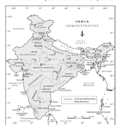
Mark the southernmost and northern most latitudes and the easternmost and westernmost longitudes.
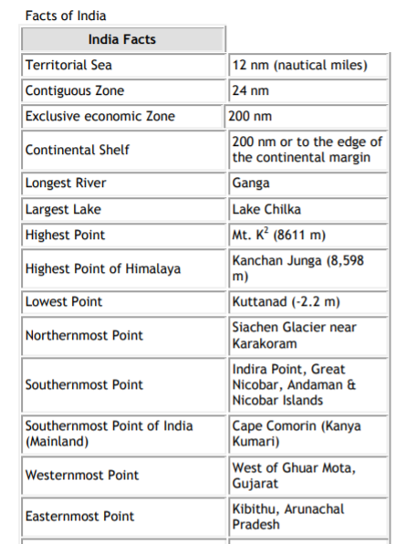
The mainland of India, extends from Kashmir in the north to Kanyakumari in the south and Arunachal Pradesh in the east to Gujarat in the west. India‘s territorial limit further extends towards the sea up to 12 nautical miles (about 21.9 km) from the coast.
Our southern boundary extends up to 6°45' N latitude in the Bay of Bengal. Let us work out implications of having such a vast longitudinal and latitudinal extent- The latitudinal and longitudinal extent of India are roughly about 30 degrees, whereas the actual distance measured from north to south extremity is 3,214 km, and that from east to west is only 2,933 km.
What is the reason for this difference?
This difference is based on the fact that the distance between two longitudes decreases towards the poles whereas the distance between two latitudes remains the same everywhere.
Find out the distance between two latitudes?
From the values of latitude, it is understood that the southern part of the country lies within the tropics and the orthern part lies in the sub-tropical zone or the warm temperate zone. This location is responsible for large variations in land forms, climate, soil types and natural vegetation in the country. Now, let us observe the longitudinal extent and its implications on the Indian people. From the values of longitude, it is quite discernible that there is a variation of nearly 30 degrees, which causes a time difference of nearly two hours between the easternmost and the westernmost parts of our country. You are familiar with the concept of Indian Standard Time (IST). What is the use of the standard meridian? While the sun rises in the northeastern states about two hours earlier as compared to Jaisalmer, the watches in Dibrugarh, Imphal in the east and Jaisalmer, Bhopal or Chennai in the other parts of India show the same time.
Why does this happen?
There is a general understanding among the countries of the world to select the standard meridian in multiples of 7°30' of longitude. That is why 82°30' E has been selected as the ‗standard meridian‘ of India. Indian Standard Time is ahead of Greenwich Mean Time by 5 hours and 30 minutes. There are some countries where there are more than one standard meridian due to their vast eastto- west extent. For example, the USA has seven time zones.
Name a few places in India through which the standard meridian passes.
1. ALLAHABAD 2. KAKINADA
India with its area of 3.28 million sq. km accounts for 2.4 per cent of the world‘s land surface area and stands as the seventh largest country in the world. Find out the names of the countries which are larger than India.
SIZE
Total area of India is 32, lakh sq. km 7th largest country with 2.4 % of total land area of the world
Indian subcontinent.
It includes the countries Pakistan, Nepal, Bhutan, Bangladesh and India.
Coastline length is 7516.5 km land frontier area is 15200 km.
INDIA AND ITS NEIGHBORS
1. Pakistan 2. China 3. Nepal 4. Bhutan 5. Myanmar 6. Bangladesh
7. Sri Lanka 8 Maldivies..
Sri Lanka is separated from India by the Gulf of Mannar and Palk Strait
Please click the link below to download pdf file for CBSE Class XI Geography India-Location Concepts.
Download CBSE Revision Notes: Class 11 Geography India Physical Environment Chapter 01 India Location
Download Chapter Summary: Class 11 Geography India Physical Environment Chapter 01 India Location
Access structured revision notes for India Physical Environment Chapter 01 India Location designed in alignment with the latest CBSE curriculum for Class 11 Geography. These summaries help clarify core themes and support effective daily study.
Concept Clarification for India Physical Environment Chapter 01 India Location
Each chapter summary is structured around standard CBSE textbooks, allowing students to check their understanding and clarify complex ideas early in their revision.
Additional Study Resources for Class 11 Geography
Explore our broader library of printable assignments, chapter notes, and mock tests designed to support continuous revision and secure higher marks in CBSE assessments.
FAQs
You can download the teacher prepared revision notes for CBSE Class 11 Geography India Location Notes from StudiesToday.com. These notes are designed as per 2026-27 academic session to help Class 11 students get the best study material for Geography.
Yes, our CBSE Class 11 Geography India Location Notes include 50% competency-based questions with focus on core logic, keyword definitions, and the practical application of Geography principles which is important for getting more marks in 2026 CBSE exams.
Yes, our CBSE Class 11 Geography India Location Notes provide a detailed, topic wise breakdown of the chapter. Fundamental definitions, complex numerical formulas and all topics of CBSE syllabus in Class 11 is covered.
These notes for Geography are organized into bullet points and easy-to-read charts. By using CBSE Class 11 Geography India Location Notes, Class 11 students fast revise formulas, key definitions before the exams.
No, all study resources on StudiesToday, including CBSE Class 11 Geography India Location Notes, are available for immediate free download. Class 11 Geography study material is available in PDF and can be downloaded on mobile.