
Download the latest CBSE Class 11 Geography Distribution Of Oceans And Continents Notes in PDF format. These Class 11 Geography revision notes are carefully designed by expert teachers to align with the 2026-27 syllabus. These notes are great daily learning and last minute exam preparation and they simplify complex topics and highlight important definitions for Class 11 students.
Revision Notes for Class 11 Geography Fundamental of Physical Geography Chapter 4 Distribution of Oceans and Continents
To secure a higher rank, students should use these Class 11 Geography Fundamental of Physical Geography Chapter 4 Distribution of Oceans and Continents notes for quick learning of important concepts. These exam-oriented summaries focus on difficult topics and high-weightage sections helpful in school tests and final examinations.
Fundamental of Physical Geography Chapter 4 Distribution of Oceans and Continents Revision Notes for Class 11 Geography
DISTRIBUTION OF OCEANS AND CONTINENTS
GIST OF THE LESSON: CONTINENTAL DRIFT, EVIDENCES TO SUPPORT CONTINENTAL DRIFT, FORCES OF DRIFTING, POST DRIFT STUDIES, OCEAN FLOOR CONFIGURATION, DISTRIBUTION OF VOLCANOES AND EARTHQUAKES, CONCEPT OF SEA FLOOR SPREADING, PLATE TECTONICS, MAJOR AND MINOR PLATES, TYPES OF PATE BOUNDARIES RATES OF PLATE MOVEMENT, FORCES OF PLATE MOVEMENT& MOVEMENT OF THE INDIAN PLATE.
CONTINENTAL DRIFT: ABRAHAM ORTELIUS a Duchy map maker 1596 first proposed the possibility of joining the continents such as America with Europe and Africa
ANTONIO PELLEGRINI drew the map showing the three continents together.
ALFRED WEGENER a German meteorologist put forth THE CONTINENTAL DRIFT THEORY. According to him,
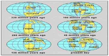
All continents formed a single continental mass called PANGAEA
All oceans formed a single universal ocean called PANTHALASSA
AROUND 200 mya THE PANGAEA BEGAN TO SPLIT INTO TWO LARGE MASSES CALLED LAURASIA and GONDWANA LAND
By further splitting Laurasia formed northern continents and Gondwana land formed southern continents.
EVIDENCES TO SUPPORT THE CONTINENTAL DRIFT
1. The matching of continents (jig-saw fit)
A. the shorelines of S. America and Africa have remarkable match
B. a map was produced by Bullard in 1964 to show the jigsaw fit of these two continents.
C. it was fit around 1000 fathom line of the shoreline
2. ROCKS OF SAME AGE ACROSS THE OCEANS
A.the belt of ancient rocks of 2000 my from Brazil coast matches with those of Western Africa
B. Marine deposits of South America and Africa belong to Jurassic age.
3.TILLITE
A. sedimentary rock formed out of glacial deposits
B. sediments from India have similar counter parts at different continents of south.
C.tillile indicates prolonged glaciations
D.The same glaciations is found in Africa, Falklands, Madagascar, Antarctica and Australia
E. the glacial tillite indicates that unambiguous evidence of palaeo climates and drifting of continents.
4.PLACER DEPOSITS
a. Formation of placer deposits of gold in Ghana coast has no source rock.
a. The gold bearing veins of rocks are found in Brazil
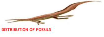
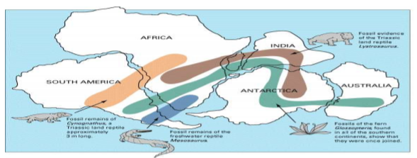
5.DISTRIBUTION OF FOSSILS
• Identical species of animals and plants are found along the coastal regions of the
different continents.
• lemurs occurs in India , Madagascar and Africa.
• The contiguous land mass was called LEMURIA
• the fossils of mesosaurus were found in only South Africa and Brazil.

FORCES FOR DRIFTING THE CONTINENTS
1. Wegner suggested that the movement responsible for the drifting of the continents was caused by
A. POLAR FLEEING FORCE B. TIDAL FORCE
Possible driving forces for plate tectonics:
2. bottom lithosphere tractions by convection currents.
3. trench pull (covered earlier).
4. ridge push (sliding off a high, crust in compression).
5. trench suck (rollback).
6. global expanding or contracting forces.
7. membrane forces on spinning ellipsoid (e.g. variants of polar fleeing forces).
TIDAL FORCE
Wegener suggested that these two forces are responsible for the movement of plates.
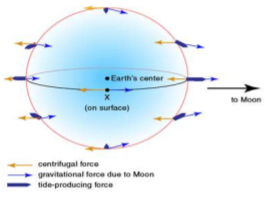
Most of the scholars consider that these forces are not sufficient to move the plates.
POST DRIFT STUDIES
Information collected from the ocean mapping is more useful to study the continental drift
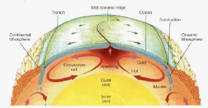
Convectional current theory
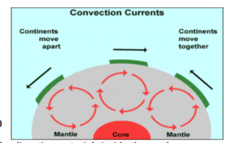
It was proposed by ARTHUR HOLMES IN 1930 Due to difference in the temperature currents are formed due to disintegration of radioactive materials inside the earth. These currents are found entire mantle portion
MAPPING OCEAN FLOOR
1. Existence of ridges and deep trenches nearby continental margins
2. Mid oceanic ridge is the most active for volcanic eruptions
3. The ocean floor is much younger than the continents
4. Rocks of equal distance of the ridge have similar chemical composition and age
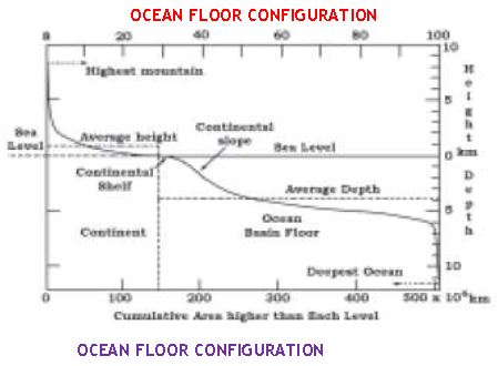
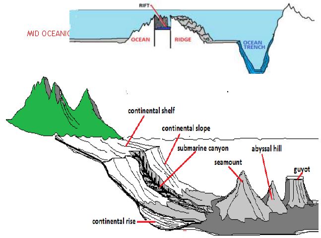
The ocean floor is segmented into three major divisions
Based on depth and configuration
1. Continental margins
a. Form transitional zone between continental shore and deep sea basins
b. They include continental slope , shelf, continental rise and deep oceanic trenches
ABYSSAL PLAINS
1. EXTENSIVE PLAINS
2.FOUND BETWEEN CONTINENTAL MARIGN AND MID OCEANIC RIDGE
3.CONTINENTAL SEDIMENTS GET DEPOSITED
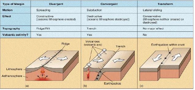
III TRANSFORM BOUNDARIES
1. Crust is neither produced nor destroyed
2. Plates slide horizontally
3. Perpendicular to the mid oceanic ridges
4. Differential movement of a plate at the same time
5. Rotation of the earth has its effect on this movement
RATES OF PLATE MOVEMENT
1. The strips of normal and reverse magnetic field helped the scientists to study the rate of plate movement
2. Arctic ridge has the slowest rate less than 2.5 cm /year east pacific rise has more than 3. 15 cm/year
FORCES OF THE PLATE MOVEMENT
1. Surface of the earth is dynamic
2. Interior is always mobile
3. Beneath the lithosphere there is always movement of magma horizontally
4. Heated material rises to the top and cooled material sinks down
5. This cycle is repeated over the time and form convection cells
SOURCES OF HEAT
A. Residual heat b. Radioactive decay
6. It was first considered by Arthur Holmes in 1930
7. Later it also influenced Harry Hess
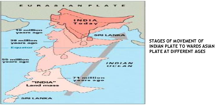
MOVEMENT OF INDIAN PLATE
1. Indian plate includes India and Australia
2. Northern boundary is along the Himalayas
3. It is the place of continental convergence
4. In the east it extends up to Rakinyoma mountains of Myanmar
5. Eastern margin is spreading site
6. Western margin extends along Kirthar mountains, Makran coast red sea rift .
7. The boundary between India and Antarctica is called divergent boundary
8. Till 225 m y a India was separated by Tethys sea
9. About 200 m y a India started its journey towards north
10. India collided with Asia about 40-50 m y a and caused the upliftment of Himalayas
11. About 140 m y a the position of Indian plate is at 50°s latitude
12. During the movement of Indian plate two events occurred in India
13. A. out pouring of lava and formation of Deccan plateau
B. Subsidence of west coast
14. The Himalayas started rising about 40 m y a
DISTRIBUTION OF VOLCANOES AND EARTHQUAKES
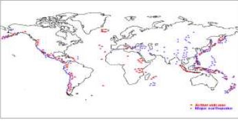
1. all volcanoes and earthquakes are paralle to the coast
2. this line also coinsides with mid- atalantic ridge
3. alpine hymalayan system
4. around the pacific ocean it is called ring of fire
Mid oceanic ridges
1. Interconnected mountain system within the ocean
2. Longest mountain chain in the ocean floor
3. Consist of central rift system at the crust
4. Intense volcanic activity is found
CONCEPT OF SEA FLOOR SPREADING
1. it was proposed by Hess in 1961
2. he believed that new lava pushes out the plates from the mid oceanic ridge
3. palaeo magnetic studies of the ocean floor reveals that
A. along the mid oceanic ridge there is intense volcanic eruption
B. huge amount of lava comes out along the mid atlanticn ridges
C. the equidistant rock formations have similar age and chemical compositions & magnetic properties
7. rocks closer to the mid oceanic ridges are young and normal polarity
8. The age of rocks increases as the distance increases from the mid oceanic ridge
9. Oceanic crust is much younger( 200my) than continental crust (3200my)
10. The sediments of ocean floor is very thisn
11. earth quakes are common along the deep sea trenches Positions of continents through geological past
PLATE TECTONICS
1. The theory of plate tectonics was introduced by McKenzie, parker and Morgan in 1967
2. A tectonic plate is also called as lithosphere plate
3. It is a massive irregularly shaped slab of solid rock
4. Consists of oceanic and continental sphere
5. Plates move horizontally over the Asthenosphere
6. Average thickness is 100 km of oceanic part and 200 km continental part
7. It may be oceanic or continental
8. Pacific plate is largest oceanic plate where as Eurasian plate is the largest continental plate
MAJOR PLATES OF THE EARTH CRUST
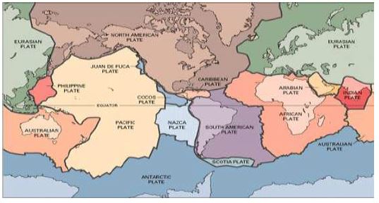
MAJOR PLATES
1. Antarctica And Surrounding Oceanic Plate
2. North American Plate
3. South American Plate Pacific Plate India-Australia-New Zealand PLATE
4. African Plate Eurasian Plate
MINOR PLATES
1. Cocos Plate 2. Nazca Plate 3. Arabian Plate 4. Philippine Plate 5. Caroline Plate 6 .Fuji Plate
These plates are moving constantly throughout geological time not the continent believed by Wegener Pangaea was the convergent of all the plates
Position of Indian subcontinent is traced with the help of rocks analyzed from Nagpur area
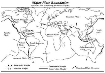
TYPES OF PLATE BOUNDARIES
I. DIVERGENT BOUNDARIES
1. New crust is generated 2. plates move away from each other
2. These are called spreading sites 3. Ex. Mid Atlantic ridge
II.CONVERGENT BOUNDARY
1. Crust is destroyed 2. sinking of plate is called „subduction zone‟
3. There are three ways in which subduction occurs
i. Ocean and continent ii. Ocean and ocean iii. continent and continent plates
CBSE Class 11 Geography Fundamental of Physical Geography Chapter 4 Distribution of Oceans and Continents Notes
Students can use these Revision Notes for Fundamental of Physical Geography Chapter 4 Distribution of Oceans and Continents to quickly understand all the main concepts. This study material has been prepared as per the latest CBSE syllabus for Class 11. Our teachers always suggest that Class 11 students read these notes regularly as they are focused on the most important topics that usually appear in school tests and final exams.
NCERT Based Fundamental of Physical Geography Chapter 4 Distribution of Oceans and Continents Summary
Our expert team has used the official NCERT book for Class 11 Geography to design these notes. These are the notes that definitely you for your current academic year. After reading the chapter summary, you should also refer to our NCERT solutions for Class 11. Always compare your understanding with our teacher prepared answers as they will help you build a very strong base in Geography.
Fundamental of Physical Geography Chapter 4 Distribution of Oceans and Continents Complete Revision and Practice
To prepare very well for y our exams, students should also solve the MCQ questions and practice worksheets provided on this page. These extra solved questions will help you to check if you have understood all the concepts of Fundamental of Physical Geography Chapter 4 Distribution of Oceans and Continents. All study material on studiestoday.com is free and updated according to the latest Geography exam patterns. Using these revision notes daily will help you feel more confident and get better marks in your exams.
FAQs
You can download the teacher prepared revision notes for CBSE Class 11 Geography Distribution Of Oceans And Continents Notes from StudiesToday.com. These notes are designed as per 2026-27 academic session to help Class 11 students get the best study material for Geography.
Yes, our CBSE Class 11 Geography Distribution Of Oceans And Continents Notes include 50% competency-based questions with focus on core logic, keyword definitions, and the practical application of Geography principles which is important for getting more marks in 2026 CBSE exams.
Yes, our CBSE Class 11 Geography Distribution Of Oceans And Continents Notes provide a detailed, topic wise breakdown of the chapter. Fundamental definitions, complex numerical formulas and all topics of CBSE syllabus in Class 11 is covered.
These notes for Geography are organized into bullet points and easy-to-read charts. By using CBSE Class 11 Geography Distribution Of Oceans And Continents Notes, Class 11 students fast revise formulas, key definitions before the exams.
No, all study resources on StudiesToday, including CBSE Class 11 Geography Distribution Of Oceans And Continents Notes, are available for immediate free download. Class 11 Geography study material is available in PDF and can be downloaded on mobile.