

Download CBSE Class 9 Social Science Useful Resources
Explore structured advanced study materials through the Class 9 Social Science Climate Exam Notes. Tailored for Class 9 learners, utilizing these Social Science resources ensures thorough preparation and strengthens foundational knowledge before final CBSE evaluations.
Access CBSE Study Guides and Summaries
Access the complete useful resource PDF for Class 9 Social Science below. Regular practice with these targeted academic notes builds familiarity with complex topics and helps secure higher marks in final school evaluations.
Class 9 Social Science Climate Exam Notes. Please refer to the examination notes which you can use for preparing and revising for exams. These notes will help you to revise the concepts quickly and get good marks.
Class 9 Social Science: Climate Exam Notes
WEATHER AND CLIMATE
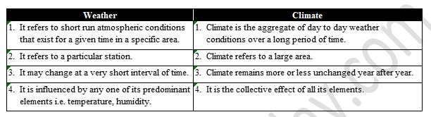
| Weather | Climate |
|---|---|
| It refers to short run atmospheric conditions at a particular time. | Climate is the aggregate of day to day weather conditions over a long period of time. |
| It refers to a particular station. | Climate refers to a large area. |
| It may change at a very short interval of time. | Climate remains more or less unchanged year after year. |
| It is influenced by any one of its predominant elements i.e. temperature, humidity. | It is the collective effect of all its elements. |
CLIMATE OF INDIA
The climate of India is described as of monsoon type. Derived from an Arabic word ‘mausim’, monsoon refers to the seasonal reversal in the wind direction through the year. This type of climate is found mainly in the south and the south east Asia. Despite an overall unity and commonality in the general pattern, there are perceptible regional variations in climatic conditions within the country. The temperature touches as high as 50ºC in the western desert during the summer season, whereas it drops down as low as –40ºC in Leh during the winter. Similarly, variations are noticeable not only in the type of precipitation but also in its amount.
CLIMATIC CONTROLS
There are six major controls of climate of any place. They are - 1. latitude 2. altitude 3. pressure and wind system 4. distance from the sea 5. ocean current 6. relief features. Latitude: Due to the curvature of the earth, the amount of solar energy received varies according to the latitude, so temperature decreases from the equator towards the poles. Altitude: Air temperature decreases with height. As one goes from the surface of the earth to higher altitudes. The atmosphere becomes less dense and temperature decreases. The hills are therefore cooler during summer. The Pressure and Winds: The pressure and wind system of any area depends on the latitude and altitude of the place. Thus it influences the temperature and rain fall pattern.
Distance from the sea: The sea exerts a moderating influence on climate. As the distance from the sea increases, its moderating influence decreases. Ocean current: Ocean current along with on shore winds affects the climate of the coastal areas. Relief: It plays a major role in determining the climate of a place. High mountains act as barriers for cold or hot winds. They may also cause precipitation.FACTORS AFFECTING THE CLIMATE OF INDIA
Latitude: The tropic of cancer passes through the middle of the country from the Rann of Kuchchh in the west to Mizoram in the east. Almost half of the country lying south of the tropic of cancer belongs to the tropical area. All the remaining area, north of the Tropic, lies in the subtropics. Therefore, India’s climate has tropical & subtropical climate. Altitude: India has mountains, to the north, which have an average height of about 6000 metres. India has a vast coastal area where the maximum elevation is about 30 metres. The Himalayas prevent the cold winds from Central Asia from entering the subcontinent. Because of these mountains, the subcontinent experiences comparatively milder winter as compared to Central Asia. Pressure and winds: The climate and associated weather conditions in India are governed by the following atmospheric condition. (A) Pressure and surface winds. (B) Upper air circulation. (C) Western cyclonic disturbances and tropical cyclone. The pressure conditions exerted by the surrounding countries like East Africa, Iran, Central Asia also influence the climate condition of India. The fury of monsoons as well as long dry spell in India are mainly due to the pressure conditions in the above mentioned countries. Winds especially typhoons, air currents and monsoon also have a great bearing on the climate of India. Typhoons originating in the China Sea also have a great bearing on the weather conditions in India. Distance from the sea: The location of seas on the three sides of India has exerted a moderate influence on much of the Indian sub continent. As the distance from the sea increases its moderating influence decreases. Physiography: It plays an important role in determining the climate of a place. The location of the Himalayas in the north has acted as a great barrier to the cold winds of the north. But for the Himalayas, India would have become a cold country.THE INDIAN MONSOON
Definition: The word monsoon comes from the Arabic word ‘mausam’ which means season. Monsoon is thus rain bearing winds which reverse their direction with the change of ‘mausam’.Facts about mechanism of Monsoons:
(A) The differential heating and cooling of land and water creates low pressure on the landmass of India while the sea around experiences comparatively high pressure. (B) The shift of the position of Inter Tropical Convergence Zone (ITCZ). In summer over the Ganga plain (This is the equatorial trough normally positioned about 5º N of the equator - also known as the monsoon trough during the monsoon season). (C) The presence of high pressure area, east of Madagascar approximately at 20ºS over the Indian ocean. The intensity and position of this high pressure area affects the Indian monsoon.
(D) The Tibetan plateau gets intensely heated during summer which results in strong vertical air currents and the formation of high pressure over the plateau at about 9 km above sea level. (E) The movements of the westerly jet stream to the north of the Himalayas and the presence of the tropical easterly jet stream over the Indian peninsula during summer. Southern Oscillation or SO: When the tropical eastern south Pacific Ocean experiences high pressure the tropical eastern Indian Ocean experiences low pressure. But in certain years, there is a reversal in the pressure conditions and the eastern Pacific has lower pressure in comparison to the eastern Indian Ocean. This periodic change in pressure condition is known as Southern Oscillation or SO. El Nino Southern Oscillations: A warm ocean current El Nino, flows past the Peruvian Coast, in place of the cold Peruvian current, every 2 to 5 years. The changes in pressure conditions are connected to the El Nino. Hence the phenomenon is referred to as ENSO. The presence of the El Nino leads to an increase in sea surface temperatures and weakening of the trade winds in the region.
THE ONSET OF THE MONSOON
The monsoon is pulsating in nature, affected by different atmospheric conditions encountered by it on way over the warm tropical seas. Around the time of its arrival the normal rainfall increases suddenly and continues constantly for several days. This is known as the 'burst of the monsoon'. The onset of the monsoon: The monsoon arrives at the southern tip of the Indian Peninsula generally by the first week of the June. Subsequently, it divides into two -
- The Arabian sea Branch. 2. The Bay of Bengal Branch.
- The Arabian sea Branch reaches Mumbai about 10 days later on approximately the 10th of June. This is fairly rapid advance.
- The Bay of Bengal branch also advances rapidly and arrives in Assam in the first week of June.
- The lofty mountains causes the monsoon winds to deflect towards the west over Ganga plains.
- By mid June the Arabian sea branch of the monsoon arrives over Saurashtra-Kuchchh and the central part of the country.
- Both the branches of the monsoon merge over the northwestern part of the Ganga plain.
- Delhi receives the monsoon showers from the Bay of Bengal branch by the end of June.
- By the first week of July, Western Uttar Pradesh, Punjab, Haryana and Eastern Rajasthan experience the monsoon.
- By mid July the monsoon reaches Himachal Pradesh and rest of the country.
WITHDRAWAL OF THE MONSOON
- It is a gradual process. It begins in northwestern states of India by early September.
- By mid October, it withdraws completely from the northern half of the peninsula.
- The withdrawal from the southern half of the peninsula is fairly rapid.
- By early December, the monsoon has withdrawn from the rest of the country.
THE SEASONS
The year can be divided into the following four seasons on the basis of the monsoon variations.
- The cold weather season: The cold weather persists from December to February throughout India. January is the coldest month. Temperature is between 10º C to 15ºC in northern plains and 25ºC in southern parts of the country. There is high pressure in northern plains due to the cold climatic conditions. The cold dry winds blow from the high pressure towards the low pressure equatorial regions. These winds are north westerly in the Ganga plains and north easterly over the Bay of Bengal. Only two parts of the country receive rain in this season. First is the north west part of India which receives rainfall from the Mediterranean cyclone. Second is the coast of Tamil Nadu which gets rainfall in winter.
- The Hot Weather Season: During this period there is a rapid shifted belt of heat from south to north. In May, the rising temperature leads to a low pressure in a wider area from the Thar desert to Chhota Nagpur. Because of this low pressure, the moisture laden winds from the Arabian Sea are attracted toward this area and consequently there is rain fall. Kerala and Western Ghats also experience the pre monsoons showers. Assam and Bengal also receive some rainfall by means of evening thunderstorms. But the north west remains dry and hot winds called the loo, engulf the whole area. Sometimes dust storms in Punjab, Haryana and U.P. are followed by light rain and cool breeze.
- Advancing Monsoon Season: This season runs from June to September. During these months the south west monsoon winds blow northwards into two branches from the Arabian sea and the Bay of Bengal. They make rainfall almost in the whole of northern India. These winds blow from the oceanic high pressure area towards the low pressure area of land and make heavy rainfall. The Arabian Sea branch causes heavy rainfall in the coastal areas of the Western Ghat but this rainfall decreases as the monsoon goes further. Kutch receives less rain fall. The Bay of Bengal causes heavy rain fall in the hills of Meghalaya. Mawsynram receives the highest rainfall in the world As the monsoon winds take a turn from east to west because of the Himalayas, the rain goes on decreasing. Due to the uncertainty and uneven distribution of rainfall, floods and droughts are common during this season.
- The Retreating Monsoon: This season runs from October to November. At this time the monsoon start retreating. The lower temperature on the plains gives rise to gradual increase in pressure and as such the monsoons retreat from most parts of North India. Depressions originate in the southern part of the Bay of Bengal and start moving towards the east coast of India. Tamil Nadu receives high rainfall from these winds during this season. The distribution and the range of rainfall is not certain even during this season.
DISTRIBUTION OF RAINFALL
- The Western Coast and North Eastern India receive over about 400 cm of rainfall annually.
- Western Rajasthan and adjoining parts of Gujarat receive less than 60 cm.
- Rain fall is equally low in the interior of the Deccan plateau and east of the Sahyadris.
- A third area of low precipitation is around Leh in Jammu and Kashmir.
- The rest of the country receives moderate rainfall.
- Snow fall is restricted to the Himalayan region.
MONSOON AS A UNIFYING BOND
Effect of the Himalayas: The Himalayas extending from north west to north east act as a great meteorological barrier. These high mountains lend the entire country, a some what tropical touch. For example the temperature is almost uniformly high throughout India during most of the year, specially during the summer months. The Himalayas act as a closed base with which the monsoon winds blow and show their unique performances. Effects of the monsoon: Moreover, the all pervading effects of the monsoons on the Indian subcontinent have also lent unity to India. With few exceptions here and there. India gets most of its rainfall due to these common winds and that to in the summer season. The concentration of rainfall over few months in a year keeps the whole land water-thirst for a greater part of the year. This thirst for water is universal throughout India. Hence, the need for developing the different means of irrigation (such as canals, wells, tube-well, etc.) is felt all over India. Thus the vagaries (uncertainties) of monsoons is felt all over the country.GLOSSARY
- Climate: Sum total of weather conditions and variations over a large area for a long period of time. The regular pattern of weather conditions of particular place.
- Weather: It refers to the state of the atmosphere over an area at any point of time.
- Range of temperature: Difference between the maximum & minimum recorded temperature.
- Precipitation: The water that falls to the earth from the atmosphere in the form of rain, snow hail, dew etc.
- Jetstream: The fast blowing air current in the upper level of atmosphere.
- Monsoon: Monsoon refers to the seasonal reversal in the wind directions throughout the year.
- Loo: It is a local wind which blows during the hot season in north India.
- Cyclone: An area of low pressure.
- Tropical climate: A relatively high temperature almost throughout the year and predominantly dry winter.
- October heat: It is the conditions of high temperature and humidity due to which the weather becomes oppressive.
- Extreme climate: The climate in which the summer is extremely hot and winter is quite cold.
- Trade winds: Trade winds are those which blow steady in the same direction and on the same course.
- Western Disturbance: Shallow cyclonic depression originating over the mediterranean sea and disturbing fine weather conditions in north western parts of India.
- Windward side: The side of the mountain where moisture winds strike and bring heavy rain.
- Leeward side: The side of the mountain which receives less rainfall.
- Rain shadow: The rainless area on the leeward side.
- Break or Burst of Monsoon: The sudden approach of the moisture laden winds which are associated with violent thunder and lightning.
- Catchment areas: The area from which the river derives its water from the hills.
- Equable climate: It is one which is neither too hot in summer nor too cold in winter. typhoon - violently revolving storm.
EXERCISE
A. VERY SHORT ANSWER TYPE QUESTIONS
What is climate ?
Answer: Climate is the average of the day-to-day weather conditions of a large area over a long period of time (about 30 years or more).
Name the elements of weather and climate.
Answer: Temperature, atmospheric pressure, winds, humidity and precipitation.
What does monsoon imply ?
Answer: The word comes from the Arabic word mausim, meaning season. Monsoon means winds that change their direction with the season.
Mention the major factors that control the climate of any place.
Answer: Latitude, altitude, pressure and wind system, distance from the sea, ocean currents and relief features.
What is Southern Oscillation ?
Answer: The periodic change in pressure between the eastern Pacific and the eastern Indian Ocean, in which the pressure over the Pacific becomes lower than over the Indian Ocean in some years, is called Southern Oscillation (SO).
What is El Nino ?
Answer: A warm ocean current that flows past the Peruvian coast, in place of the cold Peruvian current, every 2 to 5 years. It raises sea surface temperatures and weakens the trade winds.
Where are monsoon winds confined in India ?
Answer: The monsoon type of climate is found mainly in South and South-East Asia; in India the south-west monsoon brings rain to almost the whole country, and the retreating monsoon brings rain to the Tamil Nadu coast.
Where does the law pressure area develop in May ?
Answer: In May the rising temperature creates a low pressure area over a wide region from the Thar Desert to Chhota Nagpur plateau.
Name the two branches of the monsoon ?
Answer: The Arabian Sea branch and the Bay of Bengal branch.
What are the ‘retreating monsoon’ ?
Answer: The withdrawal of the monsoon from India in October-November, when the winds move back from the land to the sea.
Why does Tamil Nadu coast receive winter rainfall ?
Answer: In winter the retreating north-east monsoon winds blow from the sea to the land over the Bay of Bengal and bring rain to the Tamil Nadu coast.
What is jet stream ?
Answer: A narrow belt of very fast blowing air in the upper layers of the atmosphere.
What is the importance of Jet stream ?
Answer: It influences the weather. The westerly jet stream brings western disturbances to north India in winter, and the tropical easterly jet stream helps in the burst of the monsoon.
Name two states where mango showers are common ?
Answer: Kerala and Karnataka.
What is meant by breaking of monsoon ?
Answer: The sudden arrival of moisture-laden winds, with violent thunder and lightning, causing a sudden and continuous increase in rainfall, is called the burst of the monsoon. If the rain stops for a few days or weeks during the rainy season, it is called a break in the monsoon.
Name some regions for which the tropical cyclone are very destructive.
Answer: The coastal areas of Tamil Nadu, Andhra Pradesh, Odisha and West Bengal on the east coast.
What is loo ?
Answer: A strong, hot and dry wind that blows over the northern plains of India in the summer afternoons.
Name two hottest stations in the month of May.
Answer: Sri Ganganagar and Jaisalmer (in Rajasthan).
Write the main features of monsoon rain in India.
Answer: It is seasonal (June to September), it is uncertain and unevenly distributed, it decreases from east to west, and it comes in bursts with breaks in between.
What is cold wave ?
Answer: A sudden fall of temperature in the northern plains in winter, when very cold winds blow in from the north.
Name the states where dust storms are very common.
Answer: Punjab, Haryana, Uttar Pradesh and Rajasthan.
How is average rainfall calculated ?
Answer: By adding the rainfall of a place over many years and dividing the total by the number of years.
Write any one effect of Jet stream ?
Answer: The westerly jet stream brings western disturbances that give winter rain to north-west India.
B. SHORT ANSWER TYPE QUESTIONS
India has diverse climate condition. Explain.
Answer: The temperature touches 50°C in the Western Desert in summer but falls to −40°C at Leh in winter. Some places like the Western Ghats and Meghalaya get more than 400 cm of rain, while western Rajasthan gets less than 60 cm. So there is a great regional variation in temperature and rainfall.
Why do south-westerly winds cause rain in India ?
Answer: They blow from the Arabian Sea and the Bay of Bengal, carrying a lot of moisture. When they strike the Western Ghats and the Himalayas they rise, cool and give heavy rain.
Which are the rainiest months of India. Give reason.
Answer: June to September. During these months the south-west monsoon winds blow from the sea towards the low pressure area over land, bringing heavy rain.
Why are the parts of Rajasthan, Gujarat and leeward side of the western Ghats drought-prone ?
Answer: The moisture-laden winds lose most of their moisture on the windward side of the Western Ghats. The leeward side lies in the rain shadow, and Rajasthan and Gujarat receive very little rain from the monsoon, so these areas are often hit by drought.
‘Chennai gets more rainfall in winter than in summer’. Give two reason.
Answer: 1. The south-west monsoon winds run parallel to the east coast in summer, so Chennai lies in the rain shadow of the Western Ghats. 2. In winter the retreating monsoon crosses the Bay of Bengal, picks up moisture and brings rain to the Tamil Nadu coast.
Name and give the direction of winds that cause snow and rainfall in the northern parts of India during winter season.
Answer: Western disturbances (cyclonic disturbances from the Mediterranean region), moving from west to east, cause rain in the plains and snow in the mountains.
Name the months which are known for retreating monsoon. Write some main features of this climate.
Answer: October and November. The sky becomes clear, temperature falls slowly, pressure rises on the plains, and depressions from the Bay of Bengal bring heavy rain to the east coast, especially Tamil Nadu. Rain is uncertain.
What is October heat ?
Answer: The hot and humid weather of October, when high temperature and humidity make the weather oppressive after the monsoon withdraws.
What are western disturbances ? Name two areas receiving rains from them. Write any one benefit of these.
Answer: Western disturbances are shallow cyclonic depressions originating over the Mediterranean Sea that reach north-west India in winter. They give rain to Punjab and Haryana. They are beneficial to the rabi crops, especially wheat.
What are Jet streams ? How do they help to cause rain in Punjab and western Himalayas during the winter ?
Answer: Jet streams are fast-blowing air currents in the upper atmosphere. In winter the westerly jet stream brings the western disturbances to north-west India, which gives rain in Punjab and snow in the western Himalayas.
Why do premonsoon showers remain localised ?
Answer: They are caused by local heating, causing local convection and thunderstorms, so they do not cover a large area.
What is the difference between cyclone and anticyclone ?
Answer: A cyclone is a low pressure area with winds blowing inward and spiralling upward. An anticyclone is a high pressure area with winds blowing outward, with the air sinking from above.
Why does Mawsynram in Meghalaya receive the highest rainfall in the world ?
Answer: It is situated on the windward side of the Khasi hills, in a funnel-shaped valley where the moisture-laden winds of the Bay of Bengal are trapped and forced to rise, giving heavy rain.
Why is Cherapunji rainier than Kolkata ?
Answer: Cherapunji lies on the windward slopes of the Khasi Hills where the monsoon winds are forced to rise and give heavy rain. Kolkata is on the plains, and the winds have lost part of their moisture by then.
Why does Delhi receive more rain than Jodhpur ?
Answer: Delhi is nearer the Bay of Bengal branch of the monsoon, while Jodhpur lies on the Arabian Sea branch that runs parallel to the Aravallis; hence it has no mountains to stop the winds, so it receives very little rain.
Distinguish between summer and winter monsoon.
Answer: The summer (south-west) monsoon blows from the sea to the land from June to September, bringing heavy rain to most of India. The winter (north-east) monsoon blows from the land to the sea, is dry, and gives rain only to Tamil Nadu after crossing the Bay of Bengal.
Distinguish between windward and leeward side.
Answer: The windward side of a mountain is the side that faces the wind and receives heavy rain. The leeward side is the side that is away from the wind and receives little rain; it is called the rain shadow area.
How are the nature and mechanism of monsoon understood ?
Answer: By the differential heating of land and sea, which creates low pressure over land; the shifting of the ITCZ; the high pressure east of Madagascar; the heating of the Tibetan plateau; the westerly and easterly jet streams; and the Southern Oscillation (El Nino).
Mention any three feature of the distribution of annual rainfall in India.
Answer: 1. The western coast and north-eastern India get more than 400 cm. 2. Western Rajasthan and parts of Gujarat get less than 60 cm. 3. The interior of the Deccan plateau and the area around Leh are also dry; the rest get moderate rain.
Write two features of “mango showers”.
Answer: 1. They are pre-monsoon showers in Kerala and Karnataka. 2. They help the early ripening of mangoes.
C. LONG ANSWER TYPE QUESTIONS
Discuss the distribution of precipitation in the country and the consequences of its uneven distribution.
Answer: The western coast, the Western Ghats and north-eastern India get over 400 cm a year. Western Rajasthan and adjoining parts of Gujarat, the interior of the Deccan plateau (east of the Sahyadris) and the area around Leh get less than 60 cm. The rest get moderate rain, and snowfall is restricted to the Himalayas. Because of this uneven distribution, floods occur in some years and droughts in other years or areas. Agriculture depends on the monsoon, so crops fail, and irrigation is needed everywhere.
Discuss the factors which influence the climate of India.
Answer: 1. Latitude: the Tropic of Cancer passes through the middle, so the climate is tropical and sub-tropical. 2. Altitude: the Himalayas stop the cold winds from Central Asia, so winters are milder. 3. Pressure and winds: the pressure over surrounding areas, the jet streams, the monsoon and western disturbances affect weather. 4. Distance from the sea: the sea on three sides has a moderating effect on the coasts. 5. Physiography (relief): the Himalayas, the Western Ghats and the Thar influence rain and temperature.
Describe how the location and relief are important factor in determining the climate of India.
Answer: The Tropic of Cancer divides the country into the tropical south and sub-tropical north. The sea on three sides moderates the climate. The Himalayas act as a barrier that keeps out the cold winds from Central Asia and force the monsoon to give rain in north India; without them India would be a cold country. The Western Ghats give heavy rain on the western coast and leave the Deccan in its rain shadow.
Discuss the main features of hot weather season in India. Also write its duration.
Answer: Duration: March to May. The sun moves northward, and temperature rises, so low pressure develops from the Thar to Chhota Nagpur. The loo blows over the north-west and dust storms occur in Punjab, Haryana and U.P. Pre-monsoon showers occur in Kerala and Karnataka (mango showers), and Assam and West Bengal get evening thunderstorms (Kalbaisakhi).
What is a climatic divide ? How do the Himalayas act as climatic divide ?
Answer: A mountain range that separates areas with very different climates is a climatic divide. The Himalayas stop the very cold winds blowing from Central Asia, so India has a mild winter. They also stop the monsoon winds and force them to give rain in north India. Beyond the Himalayas (Tibet) the climate is cold and dry.
Describe the main features of advancing monsoon under the following heads. (I) Duration (II) Pressure condition (III) Prevailing winds (IV) Rain fall
Answer: Duration: June to September. Pressure: low pressure over the land and high pressure over the sea. Winds: moist south-west monsoon winds, in two branches. Rainfall: heavy rain over most of India, heaviest on the Western Ghats and Meghalaya, decreasing from east to west; it is uncertain, causing floods and droughts.
Describe the main features of Retreating monsoon under the following heads. (A) Duration (B) Pressure conditions (C) Prevailing winds (D) Rain fall
Answer: Duration: October to November. Pressure: low pressure on land shifts to the south; pressure rises on the plains. Winds: north-east monsoon winds blowing from land to sea. Rainfall: Tamil Nadu coast gets heavy rain from depressions of the Bay of Bengal; elsewhere it is dry and rain is uncertain.
Describe the regional variations in the climatic conditions of India with the help of suitable examples?
Answer: Temperature: Churu in Rajasthan touches 50°C in summer, while Drass and Leh record about −40°C in winter. Rain: Mawsynram gets about 1,100 cm, Jaisalmer less than 10 cm. The coast has a moderate climate while the interior has an extreme one. Snowfall occurs only in the Himalayas, and the Tamil Nadu coast gets rain in winter.
D. MULTIPLE CHOICE QUESTIONS
Where is monsoon type of climate mainly found ?
- South and South East Asia
- North and Northwest Asia
- North Asia
- West Asia
Answer: (A) South and South East Asia.
Which part of India experiences the highest range of temperature in a day ?
- North India
- Thar desert
- Western part
- All the above
Answer: (B) Thar desert.
Where does malabar coast lie ?
- Eastern Ghat
- South India
- Western Ghat
- None of these
Answer: (C) Western Ghat.
Name two coldest areas in India -
- Srinagar and Jammu
- Dras and Kargil
- Shillong and Kolkata
- None of these
Answer: (B) Dras and Kargil.
Name the place in India receiving highest rainfall -
- Mawsynram
- Delhi
- Chennai
- Mumbai
Answer: (A) Mawsynram.
Name two states where mango shower are common -
- Rajasthan & Bihar
- Gujarat and Tamil Nadu
- Uttar Pradesh & Madhya Pradesh
- Kerala & Karnataka
Answer: (D) Kerala & Karnataka.
Name two months associated with retreating monsoon -
- July & August
- October & November
- May & June
- All the above
Answer: (B) October & November.
What is the name given to the climate of India ?
- Cold climate
- Warm climate
- Monsoon climate
- All the above
Answer: (C) Monsoon climate.
The local wind which is hot and dry is called -
- Cyclone
- Trade wind
- Jet
- Loo
Answer: (D) Loo.
From where do western disturbances come to India ?
- Pacific ocean
- Mediterranean sea
- Indian ocean
- Bay of Bengal
Answer: (B) Mediterranean sea.
What kind of weather precedes western disturbances ?
- Cold weather
- Warm weather
- Both
- None of these
Answer: (B) Warm weather.
What is the velocity of rain bearing winds during the monsoon -
- 30 km per hour
- 40 km per hour
- 50 km per hour
- 45 km per hour
Answer: (B) 40 km per hour.
Name the water body from which the cyclonic depression originates -
- Nicobar sea
- Bay of Bengal
- Arabian sea
- Andaman sea
Answer: (D) Andaman sea. (The Andaman Sea is part of the Bay of Bengal region; the printed key gives D.)
Name the hill which deflects the Bay of Bengal branch of advancing monsoon to India -
- Nilgiri hills
- Vindhya hills
- Arakan hills
- None of these
Answer: (C) Arakan hills.
Monsoon arrives in India approximately in -
- Early May
- Early June
- Early July
- Early August
Answer: (B) Early June.
Free study material for Social Science
Useful Resources and Notes for Class 9 Social Science Contemporary India Chapter 04 Climate
Quick Revision Material for Contemporary India Chapter 04 Climate
Access comprehensive study material for Contemporary India Chapter 04 Climate, including revision notes, concept maps, and high-probability questions. These resources are designed in alignment with the latest 2026 CBSE syllabus for Class 9 Social Science to support effective exam preparation.
Expert Notes and Solved Exam Questions
Built using official NCERT guidelines for Class 9 Social Science, these materials provide reliable academic support. Integrating past examination questions and step-by-step solutions helps students understand official CBSE grading criteria.
Additional Study Resources for Class 9
Maximize your grade potential by utilizing Class 9 Social Science practice papers in tandem with these structured notes. All printable assignments and interactive mock tests on our platform are updated for the 2026 session and available free of charge.
FAQs
Our advanced study package for Contemporary India Chapter 04 Climate includes detailed concepts, diagrams, Mind Maps, and explanation of complex topics to ensure Class 9 students learn as per syllabus for 2026 exams.
The Mind Maps provided for Contemporary India Chapter 04 Climate act as visual anchors which will help faster recall during high-pressure exams.
Yes, teachers use our Class 9 Social Science resources for lesson planning as they are in simple language and have lot of solved examples.
Yes, You can download the complete, mobile-friendly PDF of the Social Science Contemporary India Chapter 04 Climate advanced resources for free.
Yes, our subject matter experts have updated the Contemporary India Chapter 04 Climate material to align with the rationalized NCERT textbooks and have removed deleted topics and added new competency-based questions.