
Read and download the CBSE Class 9 Social Science Physical Features of India Worksheet in PDF format. We have provided exhaustive and printable Class 9 Social Science worksheets for Contemporary India Chapter 2 Physical Features of India, designed by expert teachers. These resources align with the 2026-27 syllabus and examination patterns issued by NCERT, CBSE, and KVS, helping students master all important chapter topics.
Chapter-wise Worksheet for Class 9 Social Science Contemporary India Chapter 2 Physical Features of India
Students of Class 9 should use this Social Science practice paper to check their understanding of Contemporary India Chapter 2 Physical Features of India as it includes essential problems and detailed solutions. Regular self-testing with these will help you achieve higher marks in your school tests and final examinations.
Class 9 Social Science Contemporary India Chapter 2 Physical Features of India Worksheet with Answers
Chapter 2 Physical Features of India
Question. A landmass bounded by sea on three sides is referred to as
(a) Coast
(b) Peninsula
(c) Island
(d) None of the above
Answer : B
Question. Mountain ranges in the eastern part of India forming its boundary with Myanmar are collectively called as
(a) Himachal
(b) Purvachal
(c) Uttarakhand
(d) None of the above
Answer : B
Question. The western coastal strip, south of Goa is referred to as
(a) Coromandel
(b) Kannad
(c) Konkan
(d) Northern Circar
Answer : B
Question. The highest peak in the Eastern Ghats is
(a) Anai Mudi
(b) Mahendragiri
(c) Kanchenjungaa
(d) Khasi
Answer : A
Question. Answer the following questions briefly:
(i) What are tectonic plates?
(ii) Which continents of today were parts of the Gondwana land?
(iii) What is bhabar?
(iv) Name the three major divisions of the Himalayas from north to south.
(v) Which plateau lies between the Aravali and the Vindhyan ranges?
(vi) Name the island group of India having coral origin.
Answer : (i) Due to internal heat of the earth, the currents of the semi-molten rocks begin to move towards the crust and tear it apart dividing it into large fragments called lithospheric or tectonic plates. There are seven such major plates namely, South America, North America, Pacific, Indo–Australian, Eurasian, African and Antarctic.
(ii) Gondwana land is the name given to the hypothetical ‘super-continent’ located in Southern hemisphere. Gondwana Land included South America, part of Africa (south Africa including Madagascar), part of Asia (India, Arabia, Malaya), Australia and Antarctica, prior to its breakup under the forces causing continental-drift.
(iii) The ‘Bhabar’ is that narrow belt of the plain which is covered with pebbles and lies along the foothills of the Shiwaliks from the Indus to the Teesta. This belt is laid down by numerous streams descending down the hills.
(iv) The three major divisions of the Himalayas from north to south are:
a) The northernmost range which is known as the great Himalayas or Inner Himalayas or the Himadri.
b) The range lying to the south of the Himadri which is known as Himachal or the lesser Himalaya.
c) The outermost range of the Himalayas which is known as the Shiwaliks. These are the foothill ranges and represent the southernmost division of the Himalayas.
(v) Malwa plateau or Central Highland
(vi) Lakshdweep.
Question. Distinguish between
(i) Converging and diverging tectonic plates.
(ii) Bhangar and Khadar
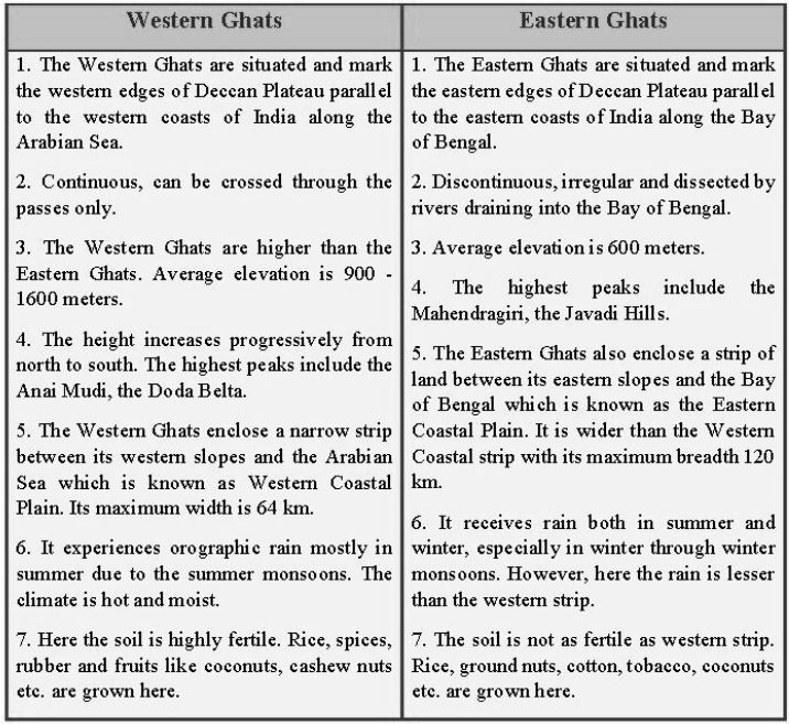
(iii) Western Ghats and Eastern Ghats.
Answer : (i) The internal heat of the earth makes the molten rocks to rush towards the surface of the earth and drive the crust into large fragments known as “Tectonic Plates”. These plates are drifting oven the mantle of the earth. As a result when the two or more plates are pushed towards each other they are called ‘Converging Plates’. On the other hand if they are moving away from each other, they are called ‘Diverging Plates’.
(ii) According to the age of the soils of the Northern Plain they have been differentiated by two names: (a) Bhangar and (b) Khadar. The difference between these two are mentioned below:
a) Bhangar - These are the older alluvium or old soil and form the largest part of the Northern Plains. They lie above the flood plains of the rivers and present a terrace like structure. It often contains Kankar nodules made of calcareous deposits.
b) Khadar - The newer and younger deposits of the flood plains are known as ‘Khadar’.
So, these are the new alluvium or new soil and are very fertile. Thus, Khadar is ideal for intensive agriculture
(iii)
Question. Describe how the Himalayas were formed.
Answer : The Indian Peninsula drifted towards the north and finally collided with the much larger Eurasian Plate. As a result of this collision, the sedimentary rocks which were accumulated in the geosynclines (known as Tethys) got folded and formed the mountain systems of the West Asia and Himalaya.
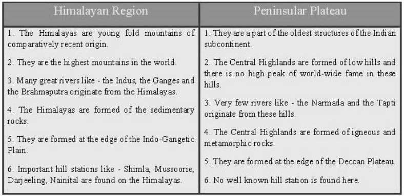
Question. Which are the major physiographic divisions of India? Contrast the relief of the Himalayan region with that of the Peninsular plateau.
Answer : The major physiographic divisions of India are the following:
a) The Himalayan Mountain Wall of the north.
b) The Northern Plains.
c) The Peninsular Plateau.
d) The Indian Dessert.
e) The Coastal Plains.
f) The Islands.
The following table compares and contrasts between the relief of the Himalayan region with that of the Peninsular plateau.
Question. Give an account of the Northern Plains of India.
Answer : The Great Northern Plain extends from the Punjab Plain in the west to the Brahmaputra valley in the east. The Northern Plain has been formed by the interplay of the three major river systems namely - the Indus, the Ganga and the Brahmaputra along with their tributaries. The deposition of alluvium in a vast basin lying at the foothills to the south of the Himalayas over millions of years formed this fertile plain. It spreads over an area of 7 lakh square km. The plain is about 2400 km long and 240 - 320 km broad. The rich soil cover combined with the abundant water supply and favourable climate made this agriculturally a very productive part of India. Because of this factor the density of population is also the highest in this region among all the physiographic divisions of India. The Northern Plain is broadly divided into three sections:
a) The Punjab Plain - It is the western part of the Northern Plain formed by the Indus and its tributaries. This section is dominated by the Doabs.
b) The Ganga Plain - It is the largest part of the Northern Plain and extends between Ghaggar and Teesta rivers.
c) The Brahmaputra Plain - It forms the eastern part of the Northern Plain by the river Brahmaputra and its tributaries. It is narrower than the Ganga Plain and is a flood prone area.
In the south-east side of the Northern Plain lays the Ganga-Brahmaputra delta which is the largest delta of the world.
Question. Write short notes on the following.
(i) The Indian Desert
(ii) The Central Highlands
Answer : (i) The Indian Desert - It is an important physiographic division of India. Some of its features are as follows:
a) It covers almost the whole of Rajasthan state.
b) It lies towards the western margins of the Aravali Hills.
c) Its vast expanse is covered with sand dunes which their shape day in and day out.
d) This region receives very little rainfall which is below 150 mm so; there are very few streams in this area.
e) It has arid climate with very little vegetation.
f) During the rainy season small streams are sometimes seen for a short-while which disappears again in sand after the rains are over.
g) Luni is the only large river in this area.
h) Crescent shape dunes which are called Barchans are a prominent feature of the Indian desert.
i) Camel is the most important animal of this desert.
(ii) The Central Highlands - The northern division of the Peninsular Plateau lying to the north of the Narmada River covering a major area of the Malwa Plateau is known as the Central Highlands. The Vindhayas and its eastern extensions divide the Central Highlands from the Deccan Plateau in the southern side. In its west lies the rocky desert of Rajasthan, in the northwest it is bounded by the Aravalis, in the north lays the Gangetic Plain and in the east it is surrounded by part of UP and south Bihar. Most part of the Central Highlands consists of the Malwa Plateau and the Chhotanagpur Plateau. The eastward extensions are known as theBundelkhand and Baghelkhand.
I Multiple choice questions. (1 mark for each)
1. In 1777, who ascended the throne of France?
a) Louis XVI b) Louis XV c) Louis XVI d) None of them.
2. Who wrote ‘what is the Third Estate’?
a) Mirabeau b) Abbe Sieyes c) Montesquieu d) Rousseau
3. The newly elected assembly, called the convention, passed the following laws.
a. Declared France a constitutional monarchy.
b. Abolished the monarchy
c. All men and women above 21 years got the right to vote
d. Declared France a republic
4. What was the name of tax which was directly paid to the state by the ‘Third Estate’?
a. Tiths b. livres c. taille d. all of the above
5. Who brought men, women and children to factories ?
a. Industrialists b. Conservatives c. Radicals d. Liberals
6. Which events normally are called Russian Revolution?
a. Fall of monarchy in Feb. 1917
b. Events in October 1917.
c. Both of them d) None of them
EXERCISE
Question. Which of the following has not been a factor in the creation and modification of India's relief features?
(a) Geological formations
(b) Population density
(c) Weathering
(d) Erosion and deposition
Answer: B
Question. According to the 'Theory of Plate Tectonics', the earth's crust is formed of how many major plates?
(a) Three
(b) Five
(c) Seven
(d) Ten
Answer: C
Question. A landmass bounded by sea on three sides is referred to as _______.
(a) Coast
(b) Island
(c) Peninsula
(d) None of the above
Answer: C
Question. Which of the following divisions of India has the oldest landmass?
(a) The Himalayas
(b) The Northern Plains
(c) The Peninsular Plateau
(d) The Indian Desert
Answer: C
Question. The Peninsular Plateau of India is part of which of the following landmass?
(a) Angaraland
(b) Gondwanaland
(c) Tethys
(d) Eurasian Plate
Answer: B
Question. Which of the following countries or continents was not part of the ancient landmass of Gondwanaland?
(a) India
(b) Australia
(c) Europe
(d) South America
Answer: C
Question. Which of the following physiographic divisions of India was formed out of accumulations in the Tethys geosyncline?
(a) The Himalayas
(b) The Northern Plains
(c) The Peninsular Plateau
(d) The Indian Desert
Answer: A
Question. Geologically which of the following physiographic divisions of India is supposed to be one of the most stable land blocks?
(a) The Himalayas
(b) The Northern Plains
(c) The Peninsular Plateau
(d) The Indian Desert
Answer: C
Question. From the point of view of geology, which of the following physiographic divisions of India is considered to be an unstable zone?
(a) The Himalayan Mountains
(b) The Peninsular Plateau
(c) The Indian Desert
(d) The Islands
Answer: A
Question. Which of the following are young fold mountains?
(a) The Aravalis
(b) The Nilgiris
(c) The Himalayas
(d) The Sahyadri
Answer: C
Question. Which of the following physical features forms a natural barrier to the north of India?
(a) Kunlun Mountains
(b) Plateau of Tibet
(c) River Brahamaputra
(d) The Himalayas
Answer: D
Question. Which part of the Himalayas is perennially snowbound?
(a) Great Himalayas or Himadri
(b) Lesser Himalayas or Himachal
(c) Shiwaliks
(d) Purvanchal
Answer: A
Question. Which of the following is the highest peak of India?
(a) Mt. Everest
(b) Kanchenjunga
(c) Nanga Prabat
(d) Nandadevi
Answer: B
Question. What are Lesser Himalayas known as?
(a) Himadri
(b) Himachal
(c) Shiwaliks
(d) Purvanchal
Answer: B
Question. Which of the following ranges are not part of the Lesser Himalayas or Himachal?
(a) Pir Panjal
(b) Dhaula Dhar
(c) Mahabharat
(d) Kamet
Answer: D
Question. A landmass bounded by sea on there sides is referred to as-
(a) Coast
(b) Island
(c) Peninsula
(d) None of the above
Answer: C
Question. Mountain ranges in the eastern part of India forming its boundary with Myanmar are collectively called as-
(a) Himachal
(b) Uttaranchal
(c) Purvanchal
(d) None of the above
Answer: C
Question. The western coastal strip, south of Goa is referred to as-
(a) Coromandal
(b) Konkan
(c) Kannad
(d) Northern Circar
Answer: C
Question. The southern most tip of Indian Union is-
(a) Indira Point
(b) Tuticorin
(c) Trivandrum
(d) Kanya Kumari
Answer: A
Question. Name the types of plate movements.
(a) Convergent
(b) Divergent
(c) Transform
(d) All of the above
Answer: D
Question. Name the oldest landmass of the Indian subcontinent.
(a) The Himalayas
(b) The Northern Plains
(c) Peninsular Plateau
(d) Island groups
Answer: C
Question. The average height of the Himadri is-
(a) 5000 meters
(b) 6000 meters
(c) 7000 meters
(d) 5500 meters
Answer: B
Question. The average width of the Himachal or lesser Himalaya is-
(a) 5km
(b) 50 km
(c) 500 km
(d) 5500 km
Answer: B
Question. The Nepal Himalayas lies between-
(a) Indus and Satluj
(b) Satluj and Kali
(c) Kali and Tista
(d) Tista and Dihang
Answer: C
Question. The total length of the Northern Plains is-
(a) 2400 km
(b) 3400 km
(c) 4200 km
(d) 5000 km
Answer: A
Question. Part of the Northern Plains, which was a thickly forested region full of wildlife, where the forests have been cleared to create agricultural land and to settle migrants from Pakistan after partition.
(a) Bhabar
(b) Terai
(c) Bhangar
(d) Khadar
Answer: B
Question. A table land composed of the old crystalline, igneous and metamorphic rocks.
(a) Himalayas
(b) Northern Plains
(c) Peninsular Plateau
(d) Coastal Plains
Answer: C
Question. The part of the Peninsular Plateau lying to the north of the Narmada River covering a major area of the Malwa plateau is known as-
(a) Eastern Ghats
(b) Western Ghats
(c) Aravalis
(d) Central Highiands
Answer: D
Question. The area where the Himalayas stand today was occupied by an ancient sea called the:
(a) Panthalasa ocean
(b) Red sea
(c) Tethys
(d) Dead Sea
Answer: C
Question. Name the island group of India that is of coral origin:
(a) Lakshdweep
(b) Rameshwaram
(c) Male
(d) Andaman and Nicobar
Answer: A
Question. Which of the following feature has similar geological structure with Meghalaya, Karbi Anglong Plateau and cachar Hills?
(a) Aravalli range
(b) Purvanchal hills
(c) Shiwaliks
(d) Chotanagpur plateau
Answer: D
Free study material for Social Science
CBSE Social Science Class 9 Contemporary India Chapter 2 Physical Features of India Worksheet
Students can use the practice questions and answers provided above for Contemporary India Chapter 2 Physical Features of India to prepare for their upcoming school tests. This resource is designed by expert teachers as per the latest 2026 syllabus released by CBSE for Class 9. We suggest that Class 9 students solve these questions daily for a strong foundation in Social Science.
Contemporary India Chapter 2 Physical Features of India Solutions & NCERT Alignment
Our expert teachers have referred to the latest NCERT book for Class 9 Social Science to create these exercises. After solving the questions you should compare your answers with our detailed solutions as they have been designed by expert teachers. You will understand the correct way to write answers for the CBSE exams. You can also see above MCQ questions for Social Science to cover every important topic in the chapter.
Class 9 Exam Preparation Strategy
Regular practice of this Class 9 Social Science study material helps you to be familiar with the most regularly asked exam topics. If you find any topic in Contemporary India Chapter 2 Physical Features of India difficult then you can refer to our NCERT solutions for Class 9 Social Science. All revision sheets and printable assignments on studiestoday.com are free and updated to help students get better scores in their school examinations.
FAQs
You can download the latest chapter-wise printable worksheets for Class 9 Social Science Contemporary India Chapter 2 Physical Features of India for free from StudiesToday.com. These have been made as per the latest CBSE curriculum for this academic year.
Yes, Class 9 Social Science worksheets for Contemporary India Chapter 2 Physical Features of India focus on activity-based learning and also competency-style questions. This helps students to apply theoretical knowledge to practical scenarios.
Yes, we have provided solved worksheets for Class 9 Social Science Contemporary India Chapter 2 Physical Features of India to help students verify their answers instantly.
Yes, our Class 9 Social Science test sheets are mobile-friendly PDFs and can be printed by teachers for classroom.
For Contemporary India Chapter 2 Physical Features of India, regular practice with our worksheets will improve question-handling speed and help students understand all technical terms and diagrams.