
Get the most accurate NCERT Solutions for Class 9 Social Science Chapter 2 Physical Features of India here. Updated for the 2026-27 academic session, these solutions are based on the latest NCERT textbooks for Class 9 Social Science. Our expert-created answers for Class 9 Social Science are available for free download in PDF format.
Detailed Chapter 2 Physical Features of India NCERT Solutions for Class 9 Social Science
For Class 9 students, solving NCERT textbook questions is the most effective way to build a strong conceptual foundation. Our Class 9 Social Science solutions follow a detailed, step-by-step approach to ensure you understand the logic behind every answer. Practicing these Chapter 2 Physical Features of India solutions will improve your exam performance.
Class 9 Social Science Chapter 2 Physical Features of India NCERT Solutions PDF
NCERT Solutions for Class 9 Social Science Geography for Chapter 2 Physical Features of India
1. Choose the right answer from the four alternatives given below.
(i) A landmass bounded by sea on three sides is referred to as
(a) Coast
(b) Island
(c) Peninsula
(d) None of the above
Answer: (c) Peninsula
(ii) Mountain ranges in the eastern part of India forming its boundary with Myanmar are collectively called as
(a) Himachal
(b) Uttarakhand
(c) Purvachal
d) None of the above
Answer: (c) Purvachal
(iii) The western coastal strip, south of Goa is referred to as
(a) Coromandel
(b) Konkan
(c) Kannad
(d) Northern Circar
Answer: (b) Konkan
(iv) The highest peak in the Eastern Ghats is
(a) Anai Mudi
(b) Kanchenjunga
(c) Mahendragiri
(d) Khasi
Answer: (c) Mahendragiri
2. Answer the following questions briefly.
(i) What are tectonic plates?
Answer: Tectonic plates are pieces of Earth's crust and uppermost mantle, together referred to as the lithosphere. The Earth's lithosphere is made up individual plates that are broken down into over a dozen large and small pieces of solid rock.
(ii) Which continents of today were part of the Gondwana land?
Answer: The Gondwanaland included India, Australia, South Africa, South America, and Antarctica as a single landmass.
(iii) What is the bhabar?
Answer: The Bhabar is that narrow belt of the north Indian plain, which is covered with pebbles and lies along the foothills of the Shiwaliks from the Indus to the Teesta.
(iv) Name the three major divisions of the Himalayas from north to south.
Answer: The three major divisions of the Himalayas from north to south are:
a. The Great Himalayas or Himadri
b. The Lesser Himalayas or Himachals c. The Outer Himalayas or Shiwaliks
(v) Which plateau lies between the Aravali and the Vindhyan ranges?
Answer: The Malwa plateau lies between the Aravali and the Vindhya Ranges.
(vi) Name the island group of India having coral origin.
Answer: Lakshadweep Islands is the island group of India having coral origin. They lie close to the Malabar Coast of Kerala in Arabian Sea.
3. Distinguish between
(i) Converging and diverging tectonic plates
Answer:
|
Converging Tectonic Plates |
Diverging Tectonic Plates |
|
i) Converging Tectonics Plates boundaries are also known as destructive plate boundaries because of subduction. |
i) Diverging Tectonic Plates boundaries are also known as a constructive boundary. |
|
ii) It is an actively deforming region where two or more tectonic plates or fragments of the lithosphere move toward each other and collide. |
ii) It is a linear feature that exists between two tectonic plates that are moving away from each other. |
(ii) Bhangar and Khadar
Answer:
|
Bhangar |
Khadar |
|
i) It is composed of old alluvium. |
i) It is composed of newer alluvium. |
|
ii) It is found in the highlands of the Northern Plains. |
ii) It is found in lowlands near the rivers. |
|
iii) It is always about the level of the flood plains. |
iii) It is flooded almost every year and new alluvium is deposited. |
|
iv) It is has calcareous concretions known as kankar. |
iv) It is often characterised by clayey soil. |
|
v) It is not much suited for cultivation as it is less fertile. |
v) Intensive agriculture is practised here as it is very fertile. |
(iii) Western Ghats and Eastern Ghats
Answer:
|
The Western Ghats |
The Eastern Ghats |
|
The Western Ghats runs parallel to the Western Coastal Plains in a north- south direction from the Tapi River to kanayakumari. |
The Eastern Ghats runs in a north-east to south-west direction parallel to the Eastern Coastal Plains from Mahanadi Valley to the Nilgiri hills. |
|
The average width of the Western Ghats is 100 km |
The average width of the Eastern Ghats vary from 100 to 200 km. |
|
The average elevation is 900 to 1,600 meters above sea-level. |
The average elevation of Eastern Ghats is about 600 metres above sea level. |
|
They are more continuous than the Eastern Ghats and can be crossed through passes only. |
They are dissected into several parts by large rivers, which drains into Bay of Bengal. |
|
The Thal, Bhor and the Pal Ghats are important passes. |
The Manchavaadi Pass in Shevaroy Hills is an important pass of the Eastern Ghats. |
|
The Anai Mudi (2,695 metres) and the Doda Betta (2,637 metres) are the highest peaks of the Western Ghats.
|
The Mahendragiri (1,501 metres) is the highest peak in the Eastern Ghats. |
4. Describe how the Himalayas were formed.
Answer: The Earth's crust was initially a single, giant super-continent called Pangaea. Its northern part was the Angaraland and the southern part was the Gondwana land. The convectional currents split the crust into a number of pieces, thus leading to the drifting of the Indo- Australian plate after being separated from the Gondwanaland, towards north. The northward drift resulted in the collision of the plate with the much larger Eurasian Plate. Due to this collision, the sedimentary rocks, which were accumulated in the geosyncline known as the Tethys, were folded to form the mountain system of western Asia and Himalaya.
5. Which are the major physiographic divisions of India? Contrast the relief of the Himalayan region with that of the Peninsular Plateau.
Answer: The physical features of India can be grouped under the following physiographic divisions
a. The Himalayan Mountains b. The Northern Plains
c. The Peninsular Plateau
d. The Indian Desert
e. The Coastal Plains f. The Islands
The Himalayas and Peninsular Plateau are different in the following ways:
|
The Himalayas |
Peninsular Plateau |
|
i) They are the young fold mountains. |
i) Peninsular plateau is the oldest massive landform of India. |
|
ii) They consists lofty mountains and deep valleys. |
ii) It has rounded hill, broad and shallow valleys. |
|
iii) They are formed due to the collision of Indo- Australian Plate and Eurasian Plate. |
iii) It formed due to breaking and drifting of Gondwana land. |
|
vi) It is composed of sedimentary rocks. |
vi) It is composed of igneous and metamorphic rocks. |
|
v) It very unstable region because it is made up of soft and unconsolidated rocks. |
v) It is more stable region as it is made up of hard rocks. |
|
vi) They give rise to the rivers like, Ganga, Yamuna, Indus, etc. |
vi) It has rivers like Narmada, Tapti, Mahanadi, etc. |
6. Give an account of the Northern Plains of India.
Answer: The Northern Plains have been formed by the interplay of the three major river systems, namely– the Indus, the Ganga and the Brahmaputra along with their tributaries. These plains are made up of alluvial soil deposited in a vast basin lying at the foothills of the Himalaya over millions of years. These are fertile plains. They spread over an area of 7 lakh sq. km. These plains are about 2400 Km long and 240 to 320 Km broad. It is a densely populated physiographic division of India.
Climate and fertile alluvial soils make the plains suitable for agriculture and the availability of water is in abundance through the year.
The northern plain is divided into three sections, i.e. the Punjab Plain, the Ganga Plain and the Brahmaputra Plain.
- The Punjab plains are formed by the Indus and its tributaries; like Jhelum, Chenab, Ravi, Beas and Sutlej.
- Ganga plains extend between Ghaggar and Tista rivers. The Indian states Haryana, Delhi, Uttar Pradesh, Bihar, part of Jharkhand and West Bengal lie in Ganga plains.
- Brahmaputra Plains form the eastern part of the northern plain and lies in Assam.
Based on the relief features; the northern plain can be divided into four regions, viz. Bhabar, Terai, Bhangar and Khadar.
- Bhabar is the gently sloping coarse alluvial zone below the Siwalik Hills.
- In the Terai region, the streams reappear and make a wet, swampy and marshy.
- Bhangar is the largest part of the northern plain and is composed of the oldest alluvial soil. The soil of this region is locally known as kankar and is composed of calcareous deposits.
- The floodplains formed by younger alluvium are called Khadar. This region is very suitable for intensive agricultural activities.
7. Write short notes on the following.
(i) The Indian Desert
Answer: The Indian Desert or the Thar Desert lies towards the western margins of the Aravali Hills. Its undulating plains are covered with the sand. This region gets scanty rainfall, which is less than 150 mm in a year. The climate found here is arid and vegetation is scanty. Luni is the only large river, but some streams appear during rainy season.
(ii) The Central Highlands
Answer: The Central Highlands is a part of the Peninsular plateau lying to the north of the Narmada River covering a major area of the Malwa plateau. The Vindhyan range is in the south and the Aravalis on the northwest of this plateau. The Chambal, the Sind, the Betwa and Ken are some of the important rivers of this region. The Central Highlands are wider in the west but narrower in the east. The eastern part of this plateau is locally known as the Bundelkhand and Baghelkhand. The Chotanagpur plateau marks the further eastward extension, drained by the Damodar River.
(iii) The Island groups of India
Ans. India has two main island groups, namely Lakshadweep and Andaman and Nicobar Islands.
Lakshadweep Islands: They consist of many small islands located opposite the Malabar Coast of Kerala in the Arabian Sea. The islands of this group are formed of coral deposits called ‘atolls’. In Malayalam, they refer to their ring or ‘horse-shoe’ shape. They cover small area of 32 sq km. Kavaratti is the administrative headquarters of Lakshadweep. This island group has great diversity of flora and fauna.
Andaman and Nicobar Islands: The Andaman and Nicobar Islands are bigger in size and has more number of islands. There are about 200 islands in the Andaman group and 19 islands in the Nicobar group. There is great diversity of flora and fauna in this group of islands too. These islands lie close to the Equator and experience equatorial climate and have thick forest cover. India’s only active volcano is found on Barren Island in Andaman and Nicobar Islands.
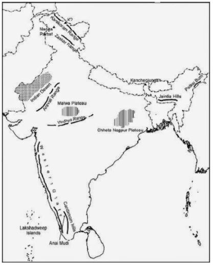
MAP SKILLS
On an outline map of India show the following.
(i) Mountain and hill ranges – the Karakoram, the Zaskar, the Patkai Bum, the Jaintia, the Vindhya Range, the Aravali, and the Cardamom Hills.
(ii) Peaks – K2, Kanchenjunga, Nanga Parbat and the Anai Mudi.
(iii) Plateaus- Chotanagpur and Malwa
(iv) The Indian Desert, Western Ghats, Lakshadweep Islands
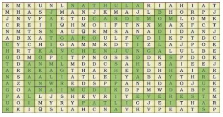
Locate the peaks, passes, ranges, plateaus, hills, and duns hidden in the puzzle.Try to find where these features are located. You may start your search horizontally, vertically or diagonally.
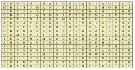
Answer
Free study material for Social Science
NCERT Solutions Class 9 Social Science Chapter 2 Physical Features of India
Students can now access the NCERT Solutions for Chapter 2 Physical Features of India prepared by teachers on our website. These solutions cover all questions in exercise in your Class 9 Social Science textbook. Each answer is updated based on the current academic session as per the latest NCERT syllabus.
Detailed Explanations for Chapter 2 Physical Features of India
Our expert teachers have provided step-by-step explanations for all the difficult questions in the Class 9 Social Science chapter. Along with the final answers, we have also explained the concept behind it to help you build stronger understanding of each topic. This will be really helpful for Class 9 students who want to understand both theoretical and practical questions. By studying these NCERT Questions and Answers your basic concepts will improve a lot.
Benefits of using Social Science Class 9 Solved Papers
Using our Social Science solutions regularly students will be able to improve their logical thinking and problem-solving speed. These Class 9 solutions are a guide for self-study and homework assistance. Along with the chapter-wise solutions, you should also refer to our Revision Notes and Sample Papers for Chapter 2 Physical Features of India to get a complete preparation experience.
FAQs
The complete and updated is available for free on StudiesToday.com. These solutions for Class 9 Social Science are as per latest NCERT curriculum.
Yes, our experts have revised the as per 2026 exam pattern. All textbook exercises have been solved and have added explanation about how the Social Science concepts are applied in case-study and assertion-reasoning questions.
Toppers recommend using NCERT language because NCERT marking schemes are strictly based on textbook definitions. Our will help students to get full marks in the theory paper.
Yes, we provide bilingual support for Class 9 Social Science. You can access in both English and Hindi medium.
Yes, you can download the entire in printable PDF format for offline study on any device.