
Get the most accurate NCERT Solutions for Class 11 Geography Chapter 9 Atmospheric circulation and weather Systems here. Updated for the 2026-27 academic session, these solutions are based on the latest NCERT textbooks for Class 11 Geography. Our expert-created answers for Class 11 Geography are available for free download in PDF format.
Detailed Chapter 9 Atmospheric circulation and weather Systems NCERT Solutions for Class 11 Geography
For Class 11 students, solving NCERT textbook questions is the most effective way to build a strong conceptual foundation. Our Class 11 Geography solutions follow a detailed, step-by-step approach to ensure you understand the logic behind every answer. Practicing these Chapter 9 Atmospheric circulation and weather Systems solutions will improve your exam performance.
Class 11 Geography Chapter 9 Atmospheric circulation and weather Systems NCERT Solutions PDF
NCERT Solution for Class 11 Geography for chapter 10 Atmospheric circulation and weather Systems
1. Multiple choice question
(i) If the surface air pressure is 1,000 mb, the air pressure at 1 km above the surface will be:
(a) 700 mb
(b) 1,100 mb
(c) 900 mb
(d) 1,300 mb
Answer: (c) 900 mb
(ii) The Inter Tropical Convergence Zone normally occurs:
(a) near the Equator
(b) near the Tropic of Cancer
(c) near the Tropic of Capricorn
(d) near the Arctic Circle
Answer: (a) near the Equator
(iii) The direction of wind around a low pressure in northern hemisphere is:
(a) clockwise
(b) perpendicular to isobars
(c) anti-clock wise
(d) parallel to isobars
Answer: (c) anti-clock wise
(iv) Which one of the following is the source region for the formation of air masses?
(a) the Equatorial forest
(b) the Himalayas
(c) the Siberian Plain
(d) the Deccan Plateau
Answer: (c) the Siberian Plain
2. Answer the following questions in about 30 words.
(i) What is the unit used in measuring pressure? Why is the pressure measured at station level reduced to the sea level in preparation of weather maps?
Answer: The atmospheric pressure is expressed in units of milibar (mb). At sea level, the average atmospheric pressure is 1,013.2 milibar. Due to gravity, the air at the surface is denser and hence has higher pressure. Pressure measure at a station is reduced to sea level to offset the effect of altitude.
(ii) While the pressure gradient force is from north to south, i.e. from the subtropical high pressure to the equator in the northern hemisphere, why are the winds north easterlies in the tropics.
Answer: The rotation of the earth on its axis affects the direction of the wind. Under the influence of Coriolis force, winds get deflected to their right in northern hemisphere and to their left in the southern hemisphere. The Coriolis force is an inertial force that acts on objects that are in motion relative to a rotating reference frame. French physicist described it in 1844. Therefore, winds are north-easterlies in the tropics of the northern hemispher
(iii) What are the geotrophic winds?
Answer: The geostrophic wind is the theoretical wind that would result from an exact balance between the Coriolis Effect and the Pressure Gradient Force.
(iv) Explain the land and sea breezes.
Answer: During the day, the land heats up faster and becomes warmer than the sea. Thus, pressure gradient from sea to land is created and the wind blows from the sea to the land as the sea breeze. In the night, the reversal of condition takes place. The land loses heat faster and is cooler than the sea. The pressure gradient is from the land to the sea and hence land breeze results.
3. Answer the following questions in about 150 words
(i) Discuss the factors affecting the speed and direction of wind.
Answer: The air in motion is called wind. The wind blows form high pressure to low pressure. However, direction and speed of wind are controlled by a combination of following factors:
Pressure Gradient Force: Differences in horizontal distribution of atmospheric pressure drives the winds from areas of high pressure to areas of low pressure. The greater the pressure gradient and its force, higher will be the wind speed.
Coriolis Effect: The rotation of the earth on its axis affects the directions of the winds. Under the influence of Coriolis force, winds get deflected to their right in northern hemisphere and to their left in the southern hemisphere.
Frictional Forces: It affects the speed of wind. Over the sea surface, the friction is minimal. Land features like mountains, plateaus and valleys bring about a change in the speed and direction of the winds.
(ii) Draw a simplified diagram to show the general circulation of the atmosphere over the globe. What are the possible reasons for the formation of subtropical high-pressure over 30° N and S latitudes?
Answer:
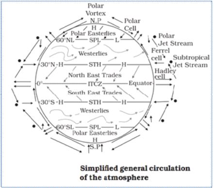
Reasons for formation of subtropical high pressure over 30°N and S latitudes: The warm air of the equatorial belt gradually cools down, when it goes up and turns towards the north and south in the northern and southern hemisphere respectively due to rotation of the earth. It reaches the top of the troposphere up to an altitude of 14 km and moves towards the poles. This causes accumulation of air at about 30° north and south part of this air sinks at ground and form subtropical high. Thus, descend of cold air causes high-pressure. Large air masses drift from the polar areas to the sub-tropics due to earth's rotation and causes high pressure there.
(iii) Why does tropical cyclone originate over the seas? In which part of the tropical cyclone do torrential rains and high velocity winds blow and why?
Answer: Tropical cyclones are violent storms that originate over oceans in tropical areas and move over to the coastal areas bringing about large-scale destruction caused by violent winds, very heavy rainfall, and storm surges.
Origin of Tropical Cyclones: The tropical cyclones originate and intensify over warm tropical oceans. Following conditions are most suitable for the birth and growth of tropical cyclones:
Large sea surface with temperature more than 27°C
Presence of the Coriolis force
Small variations in the vertical wind speed
A pre-existing weak-low-pressure area or low-level- cyclonic circulation
Upper divergence above the sea level system
Around the eye is the eye wall, where there is a strong spiralling ascent of air to greater height reaching the tropopause. The wind reaches maximum velocity in this region, reaching as high as 250 km per hour. Torrential rain occurs here. From the eye wall, rain bands may radiate and trains of cumulus and cumulonimbus clouds may drift into the outer region. The cyclone creates storm surges and they inundate the coastal low lands. The storm peters out of the land.
NCERT Solutions Class 11 Geography Chapter 9 Atmospheric circulation and weather Systems
Students can now access the NCERT Solutions for Chapter 9 Atmospheric circulation and weather Systems prepared by teachers on our website. These solutions cover all questions in exercise in your Class 11 Geography textbook. Each answer is updated based on the current academic session as per the latest NCERT syllabus.
Detailed Explanations for Chapter 9 Atmospheric circulation and weather Systems
Our expert teachers have provided step-by-step explanations for all the difficult questions in the Class 11 Geography chapter. Along with the final answers, we have also explained the concept behind it to help you build stronger understanding of each topic. This will be really helpful for Class 11 students who want to understand both theoretical and practical questions. By studying these NCERT Questions and Answers your basic concepts will improve a lot.
Benefits of using Geography Class 11 Solved Papers
Using our Geography solutions regularly students will be able to improve their logical thinking and problem-solving speed. These Class 11 solutions are a guide for self-study and homework assistance. Along with the chapter-wise solutions, you should also refer to our Revision Notes and Sample Papers for Chapter 9 Atmospheric circulation and weather Systems to get a complete preparation experience.
FAQs
The complete and updated is available for free on StudiesToday.com. These solutions for Class 11 Geography are as per latest NCERT curriculum.
Yes, our experts have revised the as per 2026 exam pattern. All textbook exercises have been solved and have added explanation about how the Geography concepts are applied in case-study and assertion-reasoning questions.
Toppers recommend using NCERT language because NCERT marking schemes are strictly based on textbook definitions. Our will help students to get full marks in the theory paper.
Yes, we provide bilingual support for Class 11 Geography. You can access in both English and Hindi medium.
Yes, you can download the entire in printable PDF format for offline study on any device.