
Get the most accurate NCERT Solutions for Class 11 Geography Chapter 3 Drainage System here. Updated for the 2026-27 academic session, these solutions are based on the latest NCERT textbooks for Class 11 Geography. Our expert-created answers for Class 11 Geography are available for free download in PDF format.
Detailed Chapter 3 Drainage System NCERT Solutions for Class 11 Geography
For Class 11 students, solving NCERT textbook questions is the most effective way to build a strong conceptual foundation. Our Class 11 Geography solutions follow a detailed, step-by-step approach to ensure you understand the logic behind every answer. Practicing these Chapter 3 Drainage System solutions will improve your exam performance.
Class 11 Geography Chapter 3 Drainage System NCERT Solutions PDF
NCERT Solutions for Class 11 Geography for Chapter 3 Drainage System
1. Choose the right answer from the four alternatives given below
(i) Which one of the following rivers was known as the ‘Sorrow of Bengal’?
(a) The Gandak
(b) The Son
(c) The Kosi
(d) The Damodar
Answer: (d) The Damodar
(ii) Which one of the following rivers has the largest river basin in India?
(a) The Indus
(b) The Brahmaputra
(c) The Ganga
(d) The Krishna
Answer: (c) The Ganga
(iii) Which one of the following rivers is not included in ‘Panchnad’?
(a) The Ravi
(b) The Chenab
(c) The Indus
(d) The Jhelum
Answer: (c) The Indus
(iv) Which one of the following rivers flows in a rift valley?
(a) The Son
(b) The Narmada
(c) The Yamuna
(d) The Luni
Answer: (b) The Narmada
(v) Which one of the following is the place of confluence of the Alaknanda and the Bhagirathi?
(a) Vishnu Prayag
(b) Rudra Prayag
(c) Karan Prayag
(d) Deva Prayag
Answer: (d) Deva Prayag
2. State the differences between the following
(i) River Basin and Watershed
Answer: The catchments of large rivers are called river basins while those of small rivulets and rills are often referred to as watersheds. Watersheds are small in area while the basins cover larger areas.
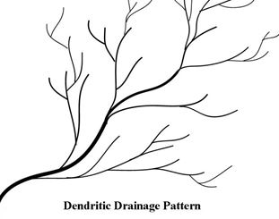
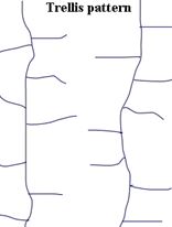
(ii) Dendritic and Trellis drainage pattern
A dendritic drainage pattern occurs when the tributary systems subdivides headway like the limbs of a tree. The drainage pattern of the Great Plains of North India is a good example of dendritic pattern.
A Trellis drainage pattern is formed when two sets of structural controls occurs at right angles. In a trellis pattern, the river forms a net like system and the tributaries flow roughly parallel to each other. The old folded mountains of the Singhbhum and rivers in the upper part of Himalaya regions have trellis drainage pattern.
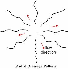
(iii) Radial and Centripetal drainage pattern
Answer:
Radial Pattern: When the rivers radiate in different directions from a hill along its slope, it is called radial pattern.
Centripetal Pattern: When the rivers flow into a depression or a lake from different directions, it is called centripetal pattern. The Thar Desert is characterised by centripetal drainage pattern.

(iv) Delta and Estuary
Answer:
Delta: The triangular deposits made by the rivers at their mouth form Delta. These are formed in the regions of low tides and coastal plains. The deltas of Ganga and Brahmaputra, Krishna, Mahanadi, etc., are most fertile.
Estuary: The sharp edged mouth of rivers, devoid of any deposits is known as Estuary. Regions of high tides and rift valleys witness Estuaries. Narmada and Tapi are two west flowing rivers, which form Estuaries in the Arabain Sea.
3. Answer the following questions in about 30 words
(i) What are the socio-economic advantages of inter-linking of rivers in India?
Answer: Inter-linking of rivers in India will help in transferring water from the surplus areas to deficit areas. This will result in removing flood and drought like situation and regional imbalances in agricultural production and will help in reduction of social disparities.
(ii) Write three characterstics of the Peninsular river.
Answer:
(a) The Peninsular rivers are reinfed and seasonal.
(b) These rivers pass through the deep valleys, therefore are not navigable.
(c) East flowing peninsular rivers like Mahanadi, Godavari, Krishna, etc., form deltas, while the west flowing rivers like Narmada and Tapi form estuaries.
4. Answer the following questions in not more than 125 words.
(i) What are the important characteristic features of north Indian rivers? How are these different from Peninsular rivers?
Answer: The Himalayan rivers are quite different from the rivers of the Peninsular India from the point of view of the drainage features and hydrological characteristics.
Himalayan rivers:
- They are perennial as they originate from the snow- covered areas and receive water from rainfall as well.
- The catchments areas and basins of the Himalayan rivers are very large.
- They perform intensive erosional activities upstream and carry large amount of load of sand and silt, and made flood plain, meanders, river bluffs and levees.
Peninsular Rivers:
- They flow through the small valleys.
- The catchments areas and basins of the Peninsular rivers are of comparatively smaller size.
- They are non-perennial and depend entirely upon rainwater.
- The peninsular rivers' like Narmada and Tapi form estuaries.
(ii) Suppose you are travelling from Haridwar to Siliguri along the foothills of the Himalayas. Name the important rivers you will come across. Describe the characteristics of any one of them.
Answer: The rivers that we come across while travelling from Haridwar to Siliguri are Ganga, Ramganga, Sarda, Rapti, Gandak and Sapt Kosi.
The Ganga is the most important river of this region. It rises in the Gangotri glacier near Gomukh in Uttarakhand at an altitude of 3,900 metres. The Ganges begins at the confluence of the Bhagirathi and Alaknanda rivers. After travelling 280 km from its source, the Ganga reaches Haridwar, debouches from the hills and enters plain area.
The total length of the Ganga is 2,525 km. It is passes through Uttarakhand, Uttar Pradesh, Bihar, Jharkhand and West Bengal. Near Rajmahal Hills it turns to the south east and south of Farraka, it ceases to be known as the Ganga. It bifurcates itself into Bhagirathi-Hugli in West Bengal and Padma-Meghna in Bangladesh. After traversing 220 km further down in Bangladesh, the Brahmaputra joins it at Goalundo and after meeting Meghna 100 km downstream the Ganga joins the Bay of Bengal.
NCERT Solutions Class 11 Geography Chapter 3 Drainage System
Students can now access the NCERT Solutions for Chapter 3 Drainage System prepared by teachers on our website. These solutions cover all questions in exercise in your Class 11 Geography textbook. Each answer is updated based on the current academic session as per the latest NCERT syllabus.
Detailed Explanations for Chapter 3 Drainage System
Our expert teachers have provided step-by-step explanations for all the difficult questions in the Class 11 Geography chapter. Along with the final answers, we have also explained the concept behind it to help you build stronger understanding of each topic. This will be really helpful for Class 11 students who want to understand both theoretical and practical questions. By studying these NCERT Questions and Answers your basic concepts will improve a lot.
Benefits of using Geography Class 11 Solved Papers
Using our Geography solutions regularly students will be able to improve their logical thinking and problem-solving speed. These Class 11 solutions are a guide for self-study and homework assistance. Along with the chapter-wise solutions, you should also refer to our Revision Notes and Sample Papers for Chapter 3 Drainage System to get a complete preparation experience.
FAQs
The complete and updated is available for free on StudiesToday.com. These solutions for Class 11 Geography are as per latest NCERT curriculum.
Yes, our experts have revised the as per 2026 exam pattern. All textbook exercises have been solved and have added explanation about how the Geography concepts are applied in case-study and assertion-reasoning questions.
Toppers recommend using NCERT language because NCERT marking schemes are strictly based on textbook definitions. Our will help students to get full marks in the theory paper.
Yes, we provide bilingual support for Class 11 Geography. You can access in both English and Hindi medium.
Yes, you can download the entire in printable PDF format for offline study on any device.