
Get the most accurate NCERT Solutions for Class 11 Geography Chapter 2 Map Scale here. Updated for the 2026-27 academic session, these solutions are based on the latest NCERT textbooks for Class 11 Geography. Our expert-created answers for Class 11 Geography are available for free download in PDF format.
Detailed Chapter 2 Map Scale NCERT Solutions for Class 11 Geography
For Class 11 students, solving NCERT textbook questions is the most effective way to build a strong conceptual foundation. Our Class 11 Geography solutions follow a detailed, step-by-step approach to ensure you understand the logic behind every answer. Practicing these Chapter 2 Map Scale solutions will improve your exam performance.
Class 11 Geography Chapter 2 Map Scale NCERT Solutions PDF
NCERT Solutions for Class 11 Geography for Chapter 2 Map Scale
Exercise
1. Choose the right answer from the four alternatives given below:
(i) Which one of the following methods of scale is a universal method?
(a) Simple Statement
(b) Representative Fraction
(c) Graphical Scale
(d) None of the above
Answer: (b) Representative Fraction
(ii) Map distance in a scale is also known as:
(a) Numerator
(b) Denominator
(c) Statement of Scale
(d) Representative Fraction
Answer: (a) Numerator
(iii) ‘Numerator’ in scale represents:
(a) Ground distance
(b) Map distance
(c) Both the distances
(d) None of the above
Answer: (b) Map distance
2. Answer the following questions in about 30 words:
(i) What are the two different systems of measurement?
Answer: Two different systems of measurement are the Metric System of Measurement and the English System of Measurement. The Metric System of Measurement (kilometer, meter, centimeter, and the millimeter) is presently used in India and the English System of Measurement (miles, furlongs, yards, and feet) is common in both the United States and the United Kingdom.
(ii) Give one example each of statement of scale in Metric and English system.
Answer: The scale of a map may be indicated in the form of a written statement. For example, in the Metric System of Measurement statement appears stating 1 cm represents 20 km, it means that on that map a distance of 1 cm is representing 20 km of the corresponding ground distance. It may also be expressed in the English System of Measurement, i.e., 1 inch represents 20 miles.
(iii) Why is the Representative Fraction method called a Universal method?
Answer: Representative Fraction is the ratio between distances on the map and the corresponding distance on the ground. Both the numerator and the denominator are in the same units, so those familiar either with the Metric Scale or English Scale can interpret the map. This quality of expressing scale in units in Representative Fraction makes it a universally acceptable and usable method.
(iv) What are the major advantages of the graphical method?
Answer: Graphical method shows map distances and the corresponding ground distances using a line bar with primary and secondary divisions marked on it. The graphical scale stands valid even when the map is reduced or enlarged. This is the unique advantage of the graphical method of the map scale.
3. Convert the given Statement of Scale into
Representative Fraction (R. F.). (i) 5 cm represents 10 km Answer:
5cm equals 10 km or
1cm equal to 2 km or
1 cm equal to 2X1000 m or
1 cm equal to 2X1000X100 cm or
NOTE : We can now replace the character “cms” into “units” and read it as :
1 unit equal to 200000 units or
R.F. 1:200000
(ii) 2 inches represents 4 miles
Answer:
2 inches represents 4 miles or
1 inch represents 2 miles or
1 inch represents 2 X 63,360 inches or
NOTE : We can now replace the character “inches” into “units” and read it as :
1 unit represents 126720 units or
R. F. 1 : 126720
(iii) 1 inch represents 1 yard
Answer:
1 inch represents 1 yard or
1 inch represents 3 feet or
1 inch represents 3X12 Inches or
NOTE : We can now replace the character “inches” into “units” and read it as :
1 unit represents 36 units or
R.F. 1:36
(iv) 1 cm represents 100 meters
Answer:
1 cm represents 100 meters OR
1 cm represents 100x100 cm
NOTE : We can now replace the character “cms” into “units” and read it as :
1 unit represents 10000 units
R.F. 1:10000
4. Convert the given Representative Fraction ( F.) into Statement of Scale in the System of Measurement shown in parentheses:
(i) 1 : 100,000 (into km)
Answer: The given R. F. of 1 : 100,000 may be converted into Statement of Scale using the following steps :
1 : 100,000 means that 1 unit on the map represents 100,000 units on the ground.
or 1 cm represents 100,000 /100,000 (1 km = 100,000 cm)
1 cm represents 1 km
(ii) 1 : 31680 (into furlongs)
Answer: The given R. F. of 1 : 31680 may be converted into Statement of Scale using the following steps :
1 : 31680 means that 1 unit on the map represents 31680 units on the ground.
or 1 inch represents 31680/7920 furlongs (1 Furlong = 7920 inches)
1 inch represents 4 furlongs
(iii) 1: 126,720 (into miles)
Answer: The given R. F. of 1 : 126,720 may be converted into Statement of Scale using the following steps :
1 : 126,720 means that 1 unit on the map represents 126,720 units on the ground.
or 1 inch represents 126,720 /63360 inches (1 mile = 63360 Inches)
1 Inch represents 2 miles
(iv) 1 : 50,000 (into meters)
Answer: The given R. F. of 1 : 50,000 may be converted into Statement of Scale using the following steps :
1 : 50,000 means that 1 unit on the map represents 50,000 units on the ground.
or 1 cm represents 50,000 /100 metres (1 metre = 100 cms)
1 cm represents 500 metres
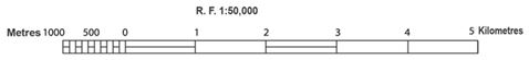
5. Construct a graphical scale when the given F. is 1 : 50,000 and read the distances in kilometer and metre.
Answer:
NCERT Solutions Class 11 Geography Chapter 2 Map Scale
Students can now access the NCERT Solutions for Chapter 2 Map Scale prepared by teachers on our website. These solutions cover all questions in exercise in your Class 11 Geography textbook. Each answer is updated based on the current academic session as per the latest NCERT syllabus.
Detailed Explanations for Chapter 2 Map Scale
Our expert teachers have provided step-by-step explanations for all the difficult questions in the Class 11 Geography chapter. Along with the final answers, we have also explained the concept behind it to help you build stronger understanding of each topic. This will be really helpful for Class 11 students who want to understand both theoretical and practical questions. By studying these NCERT Questions and Answers your basic concepts will improve a lot.
Benefits of using Geography Class 11 Solved Papers
Using our Geography solutions regularly students will be able to improve their logical thinking and problem-solving speed. These Class 11 solutions are a guide for self-study and homework assistance. Along with the chapter-wise solutions, you should also refer to our Revision Notes and Sample Papers for Chapter 2 Map Scale to get a complete preparation experience.
FAQs
The complete and updated is available for free on StudiesToday.com. These solutions for Class 11 Geography are as per latest NCERT curriculum.
Yes, our experts have revised the as per 2026 exam pattern. All textbook exercises have been solved and have added explanation about how the Geography concepts are applied in case-study and assertion-reasoning questions.
Toppers recommend using NCERT language because NCERT marking schemes are strictly based on textbook definitions. Our will help students to get full marks in the theory paper.
Yes, we provide bilingual support for Class 11 Geography. You can access in both English and Hindi medium.
Yes, you can download the entire in printable PDF format for offline study on any device.