
Get the most accurate NCERT Solutions for Class 11 Geography Chapter 5 Topographical Maps here. Updated for the 2026-27 academic session, these solutions are based on the latest NCERT textbooks for Class 11 Geography. Our expert-created answers for Class 11 Geography are available for free download in PDF format.
Detailed Chapter 5 Topographical Maps NCERT Solutions for Class 11 Geography
For Class 11 students, solving NCERT textbook questions is the most effective way to build a strong conceptual foundation. Our Class 11 Geography solutions follow a detailed, step-by-step approach to ensure you understand the logic behind every answer. Practicing these Chapter 5 Topographical Maps solutions will improve your exam performance.
Class 11 Geography Chapter 5 Topographical Maps NCERT Solutions PDF
NCERT Solutions for Class 11 Geography for Chapter 5 Topographical Maps
(i) What are topographical maps?
Answer: Topographic maps are detailed, accurate graphic representations of cultural and physical features that appear on the Earth's surface.
(ii) Name the organisation, which prepares the topographical maps of India.
Answer: The Survey of India prepares the topographical maps in India for the entire country.
(iii) Which are the commonly used scales for mapping our country used by the Survey of India?
Answer: The topographical maps of India are prepared on 1 : 10,00,000, 1 : 250,000, 1 : 1,25,000, 1 : 50,000 and 1: 25,000 scale providing a latitudinal and longitudinal coverage of 4° x 4°, 1° x 1°, 30' x 30', 15' x 15' and 5' x 7' 30", respectively.
(iv) What are contours?
Answer: Imaginary lines joining all the points of equal elevation or altitude above mean sea level are called contours. They are also called “level lines”.
(v) What does the spacing of contours indicate?
Answer: The spacing of contours indicates the slope.
(vi) What are conventional signs?
Answer: Conventional signs and symbols represent various features shown on a map, but these are not drawn to scale.
2. Write short notes on—
(i) Contours
Answer: Contours are imaginary lines joining places having the same elevation above mean sea level. A map showing the landform of an area by contours is called a contour map. Contour lines and their shapes represent the height and slope or gradient of the landform. Closely spaced contours represent steep slopes while widely spaced contours represent gentle slope. Two contours of different elevation usually do not cross each other.
(ii) ‘Marginal Information’ in Topographical sheets
Answer: Marginal information is the peripheral information on the edge of the map that provides useful information about the map to the user. It includes representative fraction, the bar scale, contour interval, lists the producer, dates of preparation and topographic symbols, etc., used to represent some of the prominent features on the map.
(iii) The Survey of India
Answer: The Survey of India is India's central engineering agency incharge of mapping and surveying. It is one of the oldest Engineering Departments of the Government of India. Survey of India publishes maps. The survey of India prepares and publishes the topographical maps for India as per the specifications laid down for the International Map Series of the World.
3. Explain what is meant by ‘map interpretation’ and what procedure is followed for its interpretatio
Answer: Map interpretation involves the study of factors that explain the causal relationship among several cultural and natural features shown on the map. For example, the distribution of urban and rural settlements can be examined in association with the levels of transport and communication network and the nature of topography.
The following steps will help in map interpretation:
Number of the topographical sheet give an idea about the location of the area in India and general characteristics of the major and minor physiographic divisions of the area.
Trace out the features likes major landforms, drainage, water features, land use, settlement and transport and communication pattern, etc.
Superimpose topographical sheets to understand the relationship between the two patterns. For example, if a contour map is superimposed over a settlement map, it provides the relationship between the degree of slope and the pattern of the settlement.
4. If you are interpreting the cultural features from a topographical sheet, what information would you like to seek and how would you derive this information? Discuss with the help of suitable examples.
Answer: Settlements, buildings, roads and railways are important cultural features shown on topographical sheets through conventional signs, symbols and colours.
The nature and causes of various settlement patterns (Compact, Scattered, Linear, and Circular) may be clearly understood by comparing the settlement map with the contour map. Density of settlement is related to food and water supply. Relief, distribution of population, and resource development pattern of an area influence the pattern and density of transport and communication and are depicted through conventional signs and symbols.
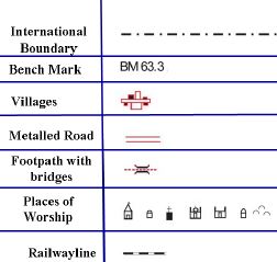
5. Draw the conventional signs and symbols for the following features—
(i) International Boundary
(ii) Bench Mark
(iii) Villages
(iv) Metalled Road
(v) Footpath with bridges
(vi) Places of Worship
(vii) Railwayline
Answer:
Exercise A
Study the contour pattern and answer the following questions.
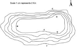
1. Name the geographical feature formed by contou
Answer: The contour lines representing a plateau because these are close spaced at the margins with the innermost contour showing wide gap between its two sides
2. Find out the contour interval in the ma
Answer: 100 m
3. Find out the map distance between E and F and convert it into ground distance.
Answer: The map distance between E and F is 2 cm, and the ground distance is 4 km.
4. Name the type of slope between A and B; C and D and E and F.
Answer:
Slope between A and B is gentle
Slope between C and D is irregular
Slope between E and F is gentle
5. Find out the direction of E, D and F from Answer:
From G the direction of E is north-east
From G the direction of D is North
From G the direction of F is south
Exercise B
Study the extract from the topographical sheet No. 63K/12, as shown in the figure below and answer the following questions—
1. Convert 1:50,000 into a statement of scale.
Answer: 1 cm represents 50000 cm or 500 mete
2. Name the major settlements of the area.
Answer: Mirzapur and Varanasi
3. What is the direction of flow of the river Ganga?
Answer: Ganga flows in the south-east direction
4. At which one of the banks of river Ganga, Bhatauli is located?
Answer: Bhatauli is located on the south bank of Ganga
5. What is the pattern of rural settlements along the right bank of river Ganga?
Answer: Rural settlements along the right bank of river Ganga are scattered
6. Name the villages/settlements where Post Office/Post and Telegraph Office are located?
Answer: Post Office/Post and Telegraph Office are located at Kachhwa, Bhatauli, Majhwan, Dhia, Baraini, etc.
7. What does the yellow colour in the area refer to?
Answer: Yellow colour in the area refers to cultivated area.
8. What means of transportation is used to cross the river by the people of Bhatauli village?
Answer: Ferry is used to cross the river by the people of Bhatauli village.
Exercise C
Study the extract for topographical sheet 63K/12 shown in the figure below and answer the following questions.
Answer: 200 m
2. River Jamtihwa Nadi is flowing through which quarter of the map?
Answer: Jamtihwa Nadi is flowing in south–east corner
3. Which is the major settlement located in the east of the Kuardari Nala?
Answer: Kotwa is located in the east of the Kuardari Nala.
Answer: There are scattered settlements.
5. Name the geographical feature represented by white patches in the middle of Sipu Nadi.
Answer: Plain
6. Name the two types of vegetation shown on part of the topographical sheet.
Answer: Deciduous Forest and Thron Forest
7. What is the direction of the flow of the Kuardari?
Answer: Kuardar Nala flows toward southwest
8. In which part of the sheet area is Lower Khajuri Dam located?
Answer: Khajuri Dam is located in the north
NCERT Solutions Class 11 Geography Chapter 5 Topographical Maps
Students can now access the NCERT Solutions for Chapter 5 Topographical Maps prepared by teachers on our website. These solutions cover all questions in exercise in your Class 11 Geography textbook. Each answer is updated based on the current academic session as per the latest NCERT syllabus.
Detailed Explanations for Chapter 5 Topographical Maps
Our expert teachers have provided step-by-step explanations for all the difficult questions in the Class 11 Geography chapter. Along with the final answers, we have also explained the concept behind it to help you build stronger understanding of each topic. This will be really helpful for Class 11 students who want to understand both theoretical and practical questions. By studying these NCERT Questions and Answers your basic concepts will improve a lot.
Benefits of using Geography Class 11 Solved Papers
Using our Geography solutions regularly students will be able to improve their logical thinking and problem-solving speed. These Class 11 solutions are a guide for self-study and homework assistance. Along with the chapter-wise solutions, you should also refer to our Revision Notes and Sample Papers for Chapter 5 Topographical Maps to get a complete preparation experience.
FAQs
The complete and updated is available for free on StudiesToday.com. These solutions for Class 11 Geography are as per latest NCERT curriculum.
Yes, our experts have revised the as per 2026 exam pattern. All textbook exercises have been solved and have added explanation about how the Geography concepts are applied in case-study and assertion-reasoning questions.
Toppers recommend using NCERT language because NCERT marking schemes are strictly based on textbook definitions. Our will help students to get full marks in the theory paper.
Yes, we provide bilingual support for Class 11 Geography. You can access in both English and Hindi medium.
Yes, you can download the entire in printable PDF format for offline study on any device.