
Download the latest CBSE Class 12 Geography Transport and Communication Notes in PDF format. These Class 12 Geography revision notes are carefully designed by expert teachers to align with the 2026-27 syllabus. These notes are great daily learning and last minute exam preparation and they simplify complex topics and highlight important definitions for Class 12 students.
Revision Notes for Class 12 Geography India People and Economy Chapter 7 Transport and Communication
To secure a higher rank, students should use these Class 12 Geography India People and Economy Chapter 7 Transport and Communication notes for quick learning of important concepts. These exam-oriented summaries focus on difficult topics and high-weightage sections helpful in school tests and final examinations.
India People and Economy Chapter 7 Transport and Communication Revision Notes for Class 12 Geography
Products like tea, milk, clothes, vegetables etc are brought from the factories and the fields to the markets with the help of transportation1 system. The availability of these products in the markets for the consumers depends on the transportation system. People not only use material things but also exchange ideas, views and messages in daily life. These exchanges take place through a communication2 system. The use of transport and communication depends upon people’s need to move things from the place of their availability to the place of their use. People use different methods to move goods, commodities and ideas from one place to another.
For the purpose of construction and maintenance, roads are classified as National Highways4 (NH), State Highways5 (SH), Major District Roads and Rural Roads.
National Highways
These roads are constructed and maintained by Central Government. They are made for inter-state transport and movement of defence personnel and material in strategic areas.
The length of National Highways has increased from 19,700 km in 1951 to 1,01011 km in 2016. These highways connect the state capitals, major cities, important ports6, railway junctions, etc. These roads carry about 40% of the road traffic, despite constituting only about 2% of total road length.
The National Highways Authority of India (NHAI) is an autonomous body, under the Ministry of Surface Transport, now Ministry of Road Transport and Highways. It was operationalised in 1995. It has been assigned with the task of development, maintenance and operation of National Highways. This is also the apex body to improve the quality of National Highways.
National Highways Development Projects
Golden Quadrilateral It is 5,846 km long, 4/6 lane high density traffic corridor. It will connect India’s four big metro cities of Delhi-Mumbai-Chennai-Kolkata. Its construction will help in reducing the time, distance, and cost of movement among mega cities considerably. North-South and East-West Corridors The North-South corridor is a 4,076 km long highway which aims to connect Srinagar in Jammu and Kashmir with Kanyakumari in Tamil Nadu (including Kochchi-Salem Spur). The East-West corridor is 3,640 km long road which aims to connect Silchar in Assam with the port town of Porbandar in Gujarat.
State Highways
State Governments are responsible to construct and maintain these highways. These roads connect the state capitals with district headquarters and other important towns. These roads are also connected to the National Highways. Their share in the total road length of the country is about 4%.
District Roads
These roads connect district headquarters and other important roads in the district. They account for 14% of the total road length of the country.
Rural Roads
These roads provide links in the rural areas. About 80% of the total road length in India are categorised as rural roads. There is regional variation in the density of Rural Roads as they are influenced by the nature of terrain (topography of the region).
Other Roads
These include Border Roads7 and International highways
l Border Roads Border roads are strategically important roads along the Northern and North-Eastern boundary of the country. Border Road Organisation (BRO) is responsible for construction and maintenance of these roads.
BRO was established in May, 1960. Its aim is to accelerate economic development and strengthen defence preparedness through rapid and co-ordinated improvement of border roads. BRO’s major achievement include the construction of roads in high altitude mountainous terrain joining Chandigarh with Manali (Himachal Pradesh) and Leh (Ladakh). This road is located at an average height of 4,270 meters above the mean sea level. Besides the construction and maintenance of roads in strategically sensitive areas, the BRO is also responsible for snow clearance in high altitude area. l International Highways They are constructed with the aim
to promote harmonious relationship with neighbouring countries by providing effective links with India.
Road Network in India 2016
Serial No. Road Category Length in Km
1. National Highways/Expressways 101011
2. State Highways 176166
3. Major District Roads 561940
4. Rural Roads 3935377
Total 4774454
Source Ministry of Road Transport and Highways Annual Report 2017-18.
Bharatmala Project
Bharatmala is a proposed umbrella scheme for
• Development of state roads along coastal border areas, including connectivity of non-major ports.
• Backward areas, religious and tourist places connectivity programme.
• Setubharatam Pariyojana, which is for the construction of about 1,500 major bridges and 200 rail over bridges and rail under bridges.
• District headquarters connectivity scheme for the development of about 9,000 km newly declared National Highways.
The programme is targeted for completion by 2022.
Rail Transport
India has one of the longest railway networks in the world.It facilitates the movement of both freight and people and contributes to the growth of economy.
In 1853, the first Indian railway line was started from Bombay to Thane covering a distance of 34 km. Indian Railway is the largest government undertaking in India. Indian Railways Network has a length of 66030 km (31st March, 2015). This large size puts huge pressure on a centralised railway management system. Thus, railways system in India has been divided into 18 zones.
Railway Zones and Headquarters
Zones Headquarters
Central Mumbai CST
Eastern Kolkata
East Central Hajipur
East Coast Bhubaneswar
Northern New Delhi
North Central Allahabad
North-Eastern Gorakhpur
North-East Frontier Maligaon (Guwahati)
North-Western Jaipur
Southern Chennai
South Central Secunderabad
South-Eastern Kolkata
South-East Central Bilaspur
South-Western Hubli
Western Mumbai (Church Gate)
West Central Jabalpur
Note In 2010, Kolkata Metro Rail was made the 17th Zone of Railway and in 2019 South Coast Railway Zone was constituted as the 18th Zone of Railways.
Railway Gauges in India
Railway gauges have been categorised into three types on the basis of the width of the track of Indian Railways.
l Broad Gauge In broad gauge, the distance between rails is 1.676 metre. The total length of broad gauge lines was 60,510 km in 2016.
l Metre Gauge In metre gauge, the distance between the rails is 1 metre. The total length of metre gauge was 3,880 km in 2016.
l Narrow Gauge In narrow gauge, the distance between the rails is 0.762 metre or 0.610 metre. The total length of narrow gauge line is 2,297 km in 2016. This category of railway lines are mostly found in the hilly areas.
Development of Railways in India
Railways were developed in India by the Britishers for the exploitation of resources. Areas around towns, raw material producing areas, areas having plantations, areas of commercial crops, hill stations, cantonment towns were well connected by railways by the Britishers.
After independence, the railway network has been extended to remote and backward areas of the country. Other steps taken to improve the performance and outreach of railways were
l Indian railways has launched extensive programmes to convert metre gauge and narrow gauge to broad gauge.
l Steam engines have been replaced by diesel and electric engines. This has increased speed as well as haulage capacity of railways. Replacement of steam engine running on coal has also improved the environment.
l The development of Konkan railway in 1988 has been a very important achievement. It runs along the West coast and provides a direct link between Mumbai and Mangalore. l Metro rail has revolutionised the urban transport system in Kolkata and Delhi.
Railways still continue to be the main means of transport for the masses. The railway network is less dense in hill states,North-Eastern states, Central India and Rajasthan.
Konkan Railway
Construction of Konkan Railway in 1998 was important achievements of Indian Railways. It is 760-km long rail route connecting Roha in Maharashtra to Mangalore in Karnataka. It is considered an engineering marvel. It crosses 146 rivers, streams, nearly 2000 bridges and 91 tunnels. Asia’s largest tunnel which is nearly 6.5 km long, also lies on this route. The states of Maharashtra, Goa and Karnataka are partners in this undertaking.
Water Transport
It is the cheapest means of transport for carrying heavy and bulky material as well as passenger services. It is a fuel efficient and eco-friendly mode of transport. The water transport is of two types i.e. Inland waterways and Oceanic waterways.
Inland Waterways
Before the introduction of railways, Inland waterways8 was the chief mode of transport. But with time its importance reduced due to tough competition from road and railway transport. Moreover, diversion of river water for irrigation purposes made the inland waterways non-navigable in large parts of their courses. India has 14,500 km of navigable waterways which accounts for about 1% of the country’s transportation. It includes rivers, canals, backwaters, creeks, etc. At present, 5,685 km of major rivers are navigable by mechanised flat bottom vessels.
The Inland Waterways Authority which was setup in 1986 is responsible for the development, maintenance and regulation of National Waterways in the country.
Some of the waterways have been declared as National Waterways of India by the Government.
| Waterways | Stretch | Specification |
| NW 1 | Allahabad- Haldia Stretch (1,620 km) | It is one of the most important waterways in India which is navigable by mechanical boats up to Patna and by ordinary boats up to Haridwar. It is divided into three parts for developmental purposes (i) Haldia-Farakka (560 km) (ii) Farakka-Patna (460 km) (iii) Patna -Allahabad (600 km) |
| NW 2 | Sadiya- Dhubri Stretch (891 km) | Brahmaputra is navigable by steamers up to Dibrugarh (1,384 km), which is shared by India and Bangladesh. |
| NW 3 | Kottapuram -Kollam Stretch (205 km) | It includes 168 km of West coast canal along with Champakara canal (14 km) and Udyogmandal canal (23 km). |
| NW 4 | Specified streches of Godavari and Krishna rivers along with Kakinada Puducherry strech of canals (1078 km). | |
| NW 5 | Specified streches of river Brahmani along withMatai River, delta channels ofMahanadi and Brahmani Rivers and East coast canals (588 km). |
[Note- In 2016, the National Waterways Act was enacted, which officially notified 111 Inland National Waterways in India]. Ten other inland waterways have been identified by Inland Waterways Authority for further development. The backwaters (Kayal) of Kerala has special significance which not only provides transport but also attracts tourists. The famous Nehru Trophy Boat Race (Vallamkali) is also held in the backwaters.
Oceanic Routes
These play an important role in the transport sector of India’s economy. India’s vast coastline of about 7,517 km (including islands) makes it suitable for this type of transport. There are 12 major and 185 minor ports which provide infrastructural support to oceanic routes. About 95% of India’s foreign trade by volume and 70% by value moves through ocean routes. These routes are used for international trade as well as for transportation between the islands and the rest of the country.
Air Transport
It facilitates the fastest movement of goods and passengers from one place to another place. It is good for a country like India, which is big in size and have diverse terrain and climatic conditions. Air transport in India was started in 1911 over a short distance (10 km) from Allahabad to Naini. But, the real development took place after independence. The Airport Authority of India is responsible for providing safe, efficient air traffic and aeronautical communication services in the Indian Air space. It manages 125 airports. Pawan Hans Limited provides helicopter services in hilly areas and also to Petroleum sector. Its services are widely used by tourist in North-Eastern sector.
Air India
It is a corporation of India which provides domestic and International Air Service for both passengers and cargo traffic. It connects all the continents of the world through its services. Now, private companies have also started domestic as well as foreign operations. In 2010, domestic movement involved 520.21 lakh passengers and about 23 lakh metric tonnes of cargo.
History of Airlines in India
• In 1911 Air Transport launched between Allahabad and Naini.
• In 1947 Air transport was provided by four major companies namely Indian National Airways, Tata Sons Limited, Air Services of India and Deccan Airways.
• In 1951 Four more companies joined the services i.e. Bharat Airways, Himalayan Aviation Limited, Airways India and Kalinga Airlines.
• In 1953 Air transport was nationalised and two corporations, Air India International and Indian Airlines were formed.
• Indian Airlines later changed its name to ‘Indian’. In 2011 Indian was merged with Air India.
Oil and Gas Pipelines
Pipelines are convenient and best means of transporting liquids and gases over long distances. These can also transport solids after converting them into slurry. Oil India Limited (OIL) under the Ministry of Petroleum and Natural Gas is responsible for exploration, production and transportation of crude oil and natural gas. Its one of the major achievements was the construction of Asia’s first cross country pipeline. This pipeline covers a distance of 1157 km from Naharkatiya oil field in Assam to Barauni refinery in Bihar.
In 1966, this pipeline was further extended to Kanpur, Uttar Pradesh. In Western region of India, OIL has also constructed extensive network of pipelines i.e. Ankleshwar-Koyali, Mumbai High-Koyali and Hazira-Vijaipur-Jagdishpur (HVJ) pipelines. Recently, a pipeline has also been constructed from Salaya (Gujarat) to Mathura (Uttar Pradesh).
It is 1,256 km long pipeline which transports crude oil from Gujarat to Punjab (Jalandhar) via Mathura. Construction of a 660 km long pipeline from Numaligarh to Siliguri is also in progress.
Communication Networks and Geographical information
Communication networks refer to the method of sharing information from one person or place to another through communication methods evolved by human beings over time. In earlier times, messages were delivered by beating drums, giving indications through smoke or fire and with the help of fast runners. Animals like horses, camels, dogs, birds were also used to send messages.
Initially, the means of communication were also the means of transportation. Invention of post-office, telegraph, printing press, satellite9 telephone has made communication much faster. Developments in science and technology has contributed in bringing about a revolution in the field of communication. On the basis of scale and quality, the modes of communication can be divided into
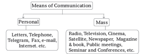
Personal Communication System
The most advanced and best means among all the personal communication system is internet which is widely used in urban cities. E-mail is the main source through which a user can directly connect with others and can also get access to the world of knowledge and information.
New modes of internet communication have also evolved after e-mail. Internet is now used for e-commerce and for carrying out money transactions.
The internet is like a huge central warehouse of data, with detailed information on various items. It is a cheaper mode of communication which provides an efficient access to information at a comparatively low cost. It enables us with the basic facilities of direct communication.
Mass Communication System
Mass communication system uses different modes of communication such as Radio, Television (TV) and Satellite communication.
Radio
Radio broadcasting was started in 1923 by Radio Club of Bombay. In a short time, it gained immense popularity and became a part of every household in India. The Government of India, in 1930 took the control of this mode of communication under Indian Broadcasting System. It was changed to All India Radio in 1936 and to Akashwani in 1957. All India Radio broadcasts various programmes related to information, education, entertainment and special news bulletins on sessions of the Parliament and State Legislatures.
Television
Television (TV) broadcasting has emerged as the most effective audio-visual medium for disseminating (spreading) information and educating masses. First television broadcasting was started in Delhi in 1959.
After 1972, several other centres became operational. In 1976, TV broadcasting services were separated by All India Radio and got a separate identity as Doordarshan (DD). After INSAT-IA (National Television -DD1) became operational, Common National Programmes (CNP) were started for the entire network and its services were extended to the backward and remote rural areas.
Satellite Communication
Satellite is an advanced mode of communication. They also regulate the use of other means of communication. Use of satellite communication is very important for the country due to economic and strategic reasons as they give continuous and synoptic view of a larger area. Various operations can be done through satellite images, e.g. weather forecast, monitoring of natural calamities, surveillance of border areas, etc. There are two satellite systems in India, on the basis of configuration and purposes
(i) Indian National Satellite System (INSAT) This was established in 1983. It is a multi-purpose satellite system for telecommunication, meteorological observation and for various other data and programmes.
(ii) Indian Remote Sensing Satellite System (IRS) The IRS satellite system started in India with the launch of IRS-IA in March 1988 from Vaikanour in Russia.
India has also developed its indigenous Launching Vehicle i.e. PSLV (Polar Satellite Launch Vehicle).
These remote sensings satellites collect data in several spectral informal band and transmit them to ground stations which is useful for various purposes and also in the management of natural resources. The National Remote Sensing Centre (NRSC) at Hyderabad is responsible for facilitating the acquisition of data and its processing.
Transport
The economy of any nation depends on its infrastructure. One of the main components of infrastructure is the transport system. The transport system plays an important role in the Indian economy. These are
- It links the interior regions to the other parts of the country, thus helping in use of resources.
- It helps in industrialisation and urbanisation.
- It transports goods from one place to another.
- It minimises the effects of natural disasters.
- It enables easy movement of people across regions.
Roadways
India has one of the largest networks of roadways in the world. The length of road per 100 sq. km. of area is known as the density of roads. Kerala has the highest density of roads.
India has a large network of 41 lakh kilometres, making it the second largest road network in the world.
This network of roads in India includes national highways, state highways, district roads and rural roads like border roads.
National Highways
Roads which run across the country and connect various cities and are maintained by the central government are known as national highways (NHs). Some facts about NHs:
- They handle about 40% of the total road traffic.
- The traffic on NHs is growing because of rapid industrialisation.
- The National Highways Authority of India (NHAI) was constituted in 1988. It is responsible for the construction of NHs and for implementing projects which are related to the improvement of NHs.
- Besides NHAI, the Public Works Department and Border Road Organisation carry out the development and maintenance of NHs.
Two major projects undertaken by NHAI are the Golden Quadrilateral and North–South and East–West Corridor.
Golden Quadrilateral
- It is the largest express highway project in India connecting the four metropolis cities of Delhi, Mumbai, Kolkata and Chennai.
- The Golden Quadrilateral has enabled the industrial growth of all small towns through which it passes and has provided an impetus to truck transport throughout India.
North–South and East–West Corridor
- The North–South and East–West Corridor is the largest ongoing highway project in India.
- It aims to connect Srinagar, Kanyakumari, Porbandar and Silchar.
Express Highways
Express highways are six-lane roads constructed to provide high-speed movement without any obstacles like speed breakers. Some major express highways in India are
Yamuna Expressway: It connects Greater Noida with Agra. It is a six-lane expressway. This expressway has reduced the travelling time between Delhi and Agra by over two hours and connects the main towns
located on the eastern side of River Yamuna. It has helped farmers to transport their agricultural,horticultural and dairy products to major cities.
Ahmedabad–Vadodara Expressway: It was India’s first four-lane expressway. It reduced the journey between Ahmedabad and Vadodara to less than 1 hour.
Mumbai–Pune Expressway: It is India’s first six-lane high-speed tolled expressway. It has separate tunnels and complete fencing to prevent crossing by humans or animals.
Panipat Expressway: It has been constructed to decongest the traffic on the busy Delhi–Amritsar route.
It is a 10-km elevated highway at Haryana.
State Highways
These are constructed and maintained by state governments. They link cities and towns within the state and connect the national highways.
Differences between national highways and state highways
National Highways State Highways
National highways are constructed and State highways are constructed and maintained by the
maintained by the central government. state government.
They connect major cities, industrial centres These connect district headquarters, tourist centres,
and pilgrim places across the country. pilgrim towns and national highways within the state.
District Roads
These roads connect areas of production with markets in a district. They also connect talukas with district headquarters within the state.
Rural Roads
Rural roads constitute about 80% of total road length in the country. These roads facilitate the movement of agricultural produce and finished goods from production centres to market centres. Prime Minister’s Rural Road Scheme was launched in December 2000 by the Government of India to provide connectivity to the rural areas.
Border Roads
The Border Road Organisation (BRO) was set up to strengthen the defence of the country. BRO has built the highest road in the world running from Manali to Leh.
Advantages of Roadways
- They provide door-to-door services.
- The cost of construction of roadways is much lower than that of railways.
- Roadways can be constructed in hilly regions.
- Roadways supplement the other modes of transport. For example, roadways connect railway stations and ports to the hinterland.
Disadvantages of Roadways
- The road network is inadequate to tackle India’s large population.
- About half of the roads are unmetalled roads, and hence, their use is restricted during the rainy season.
- The number of NHs is also not enough keeping in mind the large population of the country.
- In cities, roads are highly congested. Sometimes, the encroachment of the road by hawkers and vegetable sellers also results in congestion.
- The passing of heavily loaded trucks which carry a load above the prescribed limit also damages the roads in the long run.
The first railway service ran from Mumbai to Thane in 1853. India has one of the largest and busiest rail networks in the world. India has both long distance and suburban rail networks. New Delhi, Mumbai,Kolkata and Chennai have their own metro networks. Indian Railways help not only in the movement of people but also in the transport of goods such as fertilisers, agricultural produce, and iron and steel products.
Railways have three kinds of tracks—broad gauge, metre gauge and narrow gauge.
Broad Gauge: Almost all major rail routes are broad gauge routes. The distance between the rails is 1.676 metres. Broad gauge connects major ports with interior towns and industrial centres. It handles 85% of the total goods traffic in tones-km. It is also called India gauge. The broad gauge railway line on the west coast is known as the Konkan Railway line which is an engineering feat.
Metre Gauge: The distance between the rails is one metre. It accounts for 11.22% of the total rail route.
Narrow Gauge: The distance between the rails is 0.610–0.762 m. Metre gauge is mainly confined to the hilly regions.
Advantages of Railways
- It transports raw materials to production units and finished products to the markets.
- Bulky goods can be easily transported over a long distance.
- Railways have brought villages closer to the cities.
- It facilitates easy movement of people, police and defence equipment.
- Railways help in reducing suffering during natural calamities.
- It provides for a comfortable journey even during the nights.
Disadvantages of Railways
- Railway tracks cannot be laid down in hilly and remote forested regions.
- Every industrial town does not have railway tracks.
- Trains cannot cross oceans. They are limited to land travel and cannot transport products from one continent to the other.
- Train travel is long and tedious as compared to air travel.
Air Transport
- Air transport in India made progress after Independence. India has both domestic and international airlines. The Airports Authority of India was set up on 1 April 1995 after the merger of National Airport Authority and International Airports Authority.
- The Airports Authority of India is responsible for providing safe and efficient air traffic services in the country.
- Air India is a government-owned carrier serving 50 domestic destinations and 39 international destinations. It is the 16th largest airline in Asia. Some private airlines operating in India are Jet
Airways, GoAir and SpiceJet.
- The cargo airline companies in the country are Deccan Cargo and Express Logistics Pvt. Ltd. and Blue Aviation Pvt. Ltd.
- Pawan Hans Helicopters Ltd. (PHHL) was established with an aim to provide helicopter support services to the oil sector for offshore exploration
Advantages of Airways
- It is the fastest means of transport.
- It is also a prestigious and comfortable means of transport.
- Regions which are covered with dense forests, deserts and high mountains have easily become accessible because of air travel.
- In case of a natural calamity like floods, when roads cannot be used, relief work is carried out with the help of helicopters.
Disadvantages of Airways
- It is the costliest means of transport and hence is out of the reach of common people.
- Unlike roads and railways, airways have still not been connected to the smallest cities.
- Petroleum which is used as fuel is a non-renewable source of energy.
- Freight charges are high.
Water Transport
Waterways are the most important means of transporting bulky and heavy goods. It is a fuel-efficient and environment-friendly means of transport. Water transport can be divided into inland waterways and oceanic waterways.
Inland Waterways
Inland waterways connect rivers, canals, backwaters and creeks within the country. These waterways should be free of barriers such as waterfalls and rapids. Inland Waterways Authority of India (IWAI) is in
charge of the waterways in India. It has declared five inland waterways as national waterways. These are
Name of Inland Waterway Features
National Waterway No. 1 Comprises the Ganga–Bhagirathi–Hooghly river system connecting
Haldia–Kolkata–Farakka–Munger–Patna–Varanasi–Allahabad.
National Waterway No. 2 River Brahmaputra connects Dhubri–Pandu–Tezpur–Neamati– Dibrugarh–Sadiya.
National Waterway No. 3 Comprises the West Coast Canal along Champakaran and
Udyogmandal. It was declared a national waterway in 1993.
National Waterway No. 4 Connects Andhra Pradesh, Tamil Nadu and Puducherry.
National Waterway No. 5 Comprises the Talcher–Dharma stretch of River Brahmi, the
Goenkhali–Charbatia stretch of the East Coast Canal and the
Charbatia Dharma stretch of Malti River along with the Mahanadi delta.
The following waterways have been declared as national waterways by the government:
- The River Ganga between Allahabad and Haldia
- The River Brahmaputra between Sadiya and Dhubri
- The West Coast Canal in Kerala
Apart from the Ganga and the Brahmaputra, Godavari, Krishna and Buckingham Canal and East–West Canal are important inland waterways.
Oceanic Waterways
India is a peninsular country with a long coastline of 7517 km. It has 12 major sea ports and 187 minor sea ports.
Sea ports handle over 80% of all cargo traffic. Some major sea ports in India are
- Mumbai Port is the largest port in the country. Jawaharlal Nehru Port was built to decongest the Mumbai Port. Apart from various other goods, Mumbai Port deals with mineral oil and dry cargo.
- Mormugao Port in Goa is an important iron ore-exporting port in the country. It is a natural harbour and occupies the fifth position in total traffic handled.
- Kolkata is an inland riverine port. Haldia Port was developed on the River Hooghly to reduce pressure on the Kolkata Port.
- Paradip Port is located on the coast of Odisha and handles iron ore and coal.
- Vishakhapatnam Port in Andhra Pradesh is the deepest landlocked port which handles crude oil and petroleum products.
- Chennai is one of the oldest artificial ports of the country. It is next to Mumbai in trading activities. It handles petroleum products, crude oil, fertilisers, iron ore and dry cargo.
- Tuticorin Port in Tamil Nadu has a natural harbour and mainly handles coal, salt, edible salt, dry cargo and petroleum products.
- Kandla Port is a tidal port located in Gujarat. It handles crude oil, petroleum products, edible oil, food grains, cotton and salt.
- New Mangalore in Karnataka exports iron ore of Kudremukh and imports petroleum products, fertilisers and edible oils.
- Kochi Port is located in the southwestern part of the country. It has been developed alongside a natural harbour. It handles the export of tea, coffee and spices and the imports of petroleum oil and fertilisers.
Differences between Oceanic Waterways and Inland Waterways Oceanic waterways Inland waterways
It includes transport along the coastline. It includes transport through navigable rivers and canals.
Coastal and foreign trade usually takes place through oceanic waterways.
Domestic trade takes place through inland waterways.
Advantages of Waterways
- It is the cheapest means of transport.
- It is suitable for carrying heavy and bulky materials.
- It is a fuel-efficient and eco-friendly mode of transport.
- It is safe and has less traffic in comparison to road and air transport.
Disadvantages of Waterways
- It is dependent on the weather.
- It involves long hours of travel which cause sickness.
- It is limited to areas where rivers are navigable and where an oceanic route exists.
CBSE Class 12 Geography India People and Economy Chapter 7 Transport and Communication Notes
Students can use these Revision Notes for India People and Economy Chapter 7 Transport and Communication to quickly understand all the main concepts. This study material has been prepared as per the latest CBSE syllabus for Class 12. Our teachers always suggest that Class 12 students read these notes regularly as they are focused on the most important topics that usually appear in school tests and final exams.
NCERT Based India People and Economy Chapter 7 Transport and Communication Summary
Our expert team has used the official NCERT book for Class 12 Geography to design these notes. These are the notes that definitely you for your current academic year. After reading the chapter summary, you should also refer to our NCERT solutions for Class 12. Always compare your understanding with our teacher prepared answers as they will help you build a very strong base in Geography.
India People and Economy Chapter 7 Transport and Communication Complete Revision and Practice
To prepare very well for y our exams, students should also solve the MCQ questions and practice worksheets provided on this page. These extra solved questions will help you to check if you have understood all the concepts of India People and Economy Chapter 7 Transport and Communication. All study material on studiestoday.com is free and updated according to the latest Geography exam patterns. Using these revision notes daily will help you feel more confident and get better marks in your exams.
FAQs
You can download the teacher prepared revision notes for CBSE Class 12 Geography Transport and Communication Notes from StudiesToday.com. These notes are designed as per 2026-27 academic session to help Class 12 students get the best study material for Geography.
Yes, our CBSE Class 12 Geography Transport and Communication Notes include 50% competency-based questions with focus on core logic, keyword definitions, and the practical application of Geography principles which is important for getting more marks in 2026 CBSE exams.
Yes, our CBSE Class 12 Geography Transport and Communication Notes provide a detailed, topic wise breakdown of the chapter. Fundamental definitions, complex numerical formulas and all topics of CBSE syllabus in Class 12 is covered.
These notes for Geography are organized into bullet points and easy-to-read charts. By using CBSE Class 12 Geography Transport and Communication Notes, Class 12 students fast revise formulas, key definitions before the exams.
No, all study resources on StudiesToday, including CBSE Class 12 Geography Transport and Communication Notes, are available for immediate free download. Class 12 Geography study material is available in PDF and can be downloaded on mobile.