
Read and download the CBSE Class 10 Social Science Lifelines Of Indian Economy Worksheet in PDF format. We have provided exhaustive and printable Class 10 Social Science worksheets for Contemporary India Chapter 7 Lifelines of National Economy, designed by expert teachers. These resources align with the 2026-27 syllabus and examination patterns issued by NCERT, CBSE, and KVS, helping students master all important chapter topics.
Chapter-wise Worksheet for Class 10 Social Science Contemporary India Chapter 7 Lifelines of National Economy
Students of Class 10 should use this Social Science practice paper to check their understanding of Contemporary India Chapter 7 Lifelines of National Economy as it includes essential problems and detailed solutions. Regular self-testing with these will help you achieve higher marks in your school tests and final examinations.
Class 10 Social Science Contemporary India Chapter 7 Lifelines of National Economy Worksheet with Answers
Objective Questions
Question : Which of the following visits India for heritage tourism, eco tourism, adventure tourism, cultural tourism, medical tourism and business tourism?
(a) Foreign tourists
(b) Local tourists
(c) Students as tourists
(d) None of the above
Answer : A
Question : Which one of the following is the eastern terminal of East-West Corridor?
(a) Shilong
(b) Silvassa
(c) Silchar
(d) Singrauli
Answer : C
Question : Which one of the following ports was developed to relieve the pressure on Kolkata port?
(a) Haldia
(b) Paradip
(c) Vishakhapatnam
(d) Navasheva
Answer : A
Question : Which of the following National Highway is called Sher-Shah Suri Marg?
(a) National Highway-5
(b) National Highway-7
(c) National Highway-1
(d) National Highway-9
Answer : C
Question : The North-South corridor links :
(a) Srinagar and Kanyakumari
(b) Himachal and Kanyakumari
(c) Srinagar and Chennai
(d) Srinagar and Andaman Nicobar
Answer : A
Question : Which two of the following extreme locations are connected by the East-West Corridors?
(a) Srinagar and Kanyakumari
(b) Silchar and Porbandar
(c) Mumbai and Kolkata
(d) Nagpur and Siligudi
Answer : B
Question : Under the government scheme of ______, every village of the country is linked to a major town in the country by a motorable road.
(a) Grameen Sadak Yojana
(b) PM Sadan Yojana
(c) Prime Minister Village Road Scheme
(d) Pradhan Mantri Grameen Sadak Yojana
Answer : D
Question : With the development in ______ and ______, the area of influence of trade and transport expanded far and wide.
(a) science
(b) technology
(c) both (a) and (b)
(d) none
Answer : C
Question : Indian railways have a network of how many stations ?
(a) 7,013
(b) 7,349
(c) 7,103
(d) 7,439
Answer : B
Question : In how many zones are Indian Railways organized ?
(a) 10
(b) 12
(c) 14
(d) 16
Answer : D
Question : Which places in India are connected by National Highway – 1 ?
(a) Delhi-Amritsar
(b) Delhi-Patiala
(c) Delhi-Kahmir
(d) Delhi-Lucknow
Answer : A
Question : Which one of the following states is not connected with the H.V.J. pipeline?
(a) Madhya Pradesh
(b) Maharashtra
(c) Gujarat
(d) Uttar Pradesh
Answer : B
Question : Which of the following roads received special impetus under the Pradhan Mantri Grameen Sadak Yojana?
(a) Rural roads
(b) Urban roads
(c) District roads
(d) National Highways
Answer : A
Question : Government’s project of linking all the four metro cities is called __________ .
(a) Golden Quadrilateral
(b) Golden Triangle
(c) Golden Square
(d) Super Highways
Answer : A
Question : Sher Shah Suri Marg, National Highway No. 1, is between __________ .
(a) Delhi-Amritsar
(b) Punjab-Haryana
(c) Delhi-Punjab
(d) Amritsar-Ludhiana
Answer : A
Question : Construction cost of roadways is __________ than that of railways.
(a) higher
(b) lower
(c) much Lower
(d) much Higher
Answer : C
Question : How much is the contribution of agriculture and allied products in the export of India?
(a) 7.5%
(b) 17.34%
(c) 22.62%
(d) 6.3%
Answer : B
Question : Which among the following is the full form of CPWD?
(a) Control Public Works Department
(b) Central Public Wind Department
(c) Central Public Works Department
(d) Central Prime Works Department
Answer : C
Question : is the longest National Highway ?
(a) National Highway No. 1
(b) National Highway No. 3
(c) National Highway No. 5
(d) National Highway No. 7
Answer : D
Question : __________ connect a state capital with different district headquarters.
(a) District Highways
(b) National Highways
(c) State Highways
(d) Other Roads
Answer : C
Question : When was the Border Road Organization established?
(a) 1950
(b) 1955
(c) 1960
(d) 1965
Answer : C
Question : Which is the most comfortable, fastest and prestigious mode of transport?
(a) Airways
(b) Waterways
(c) Pipelines
(d) Roadways
Answer : A
Question : Which country has the largest telecom network in Asia?
(a) China
(b) Japan
(c) India
(d) Sri Lanka
Answer : C
Question : Which among the following is the full form of STD?
(a) Subscriber Trunk Dialling
(b) Sarkari Tower Department
(c) Sarkar Trunk Dialling
(d) Subscriber Tower Dialling
Answer : A
Question : Which among of the following does not provide Mass Communication ?
(a) Akashwani
(b) Doordarshan
(c) Dainik Jagran
(d) None of these
Answer : D
Question : Air transport was nationalised in the year:
(a) 1948
(b) 1953
(c) 1970
(d) 1960
Answer : B
Question : What is the major objective of the Super Highways?
(a) To reduce time and distance between mega cities.
(b) To break inter-state barriers.
(c) To compete with the railways in India.
(d) None of these
Answer : A
Question : The National Highway 1 connects which of the following places in India?
(a) Delhi-Amritsar
(b) Delhi-Patiala
(c) Delhi-Kahmir
(d) Delhi-Lucknow
Answer : A
Question : How many type of important networks of pipeline transportation are there in the country?
(a) One
(b) Two
(c) Three
(d) Four
Answer : C
Question : How many railway zones are there in India?
(a) 14 zones
(b) 15 zones
(c) 16 zones
(d) 18 zones
Answer : C
Question : The highway projects are being implement by:
(a) Central Public Words Department
(b) State Public Works Department
(c) National Highway Authority of India
(d) Both (a) and (c)
Answer : C
Question : Which of the following promotes national integration and provides support to local handicrafts and cultural pursuits?
(a) Tourism
(b) Sports
(c) Services
(d) National Heritages
Answer : A
Fill In The Blanks
True/False
Assertion And Reasoning Based Questions
Reason : Transport and communications do not help in easy movement of goods and materials between countries
Answer : (c) If Assertion is true but reason is false.
Very Short Answer Type Questions
Question : Where is New Mangalore port located?
Answer : This port is located is Karnataka.
Question : Which is the deepest landlocked and well protected port?
Answer : Visakhapatnam is the deepest landlocked and well protected port.
Question : What is the major objective of the super Highways?
Answer : The major objective of the Super Highways is to reduce the time and distance between the mega cities of India.
Question : What do you know about National Highways?
Answer : National Highways are the primary road systems and are laid and maintained by the Central Public Works Department (CPWD).
Question : Why was Haldia port developed?
Answer : Haldia port was developed as a subsidiary port, in order to relieve growing pressure on the Kolkata port.
Question : What are considered first-class mail by the Indian postal network?
Answer : Cards and envelopes are considered first-class mail.
Question : Complete the following table with appropriate terms in places of A and B.
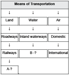
Answer : A - Pipeline, B - Overseas
Question : Which is the oldest artificial sea port of India?
Answer : Chennai port is the oldest artificial sea port of India.
Question : Which factors influence the distribution pattern of the railway network in the country ?
Answer : Physiographic, economic and administrative factors influence the distribution pattern of the railway network in the country.
Question : Which air transport provides domestic air services?
Answer : Air India, Indian airlines, Alliance Air, private scheduled airlines and nonscheduled operators provide domestic air services.
Question : What are the major means of communication in our country?
Answer : The major means of communication in our country are television, radio, press and films.
Question : Complete the following table with correct information with regard to Indian Railways
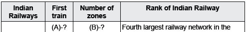
![]()
Answer : (A)-Steamed off from Mumbai to Thane, (B)-16 zones
Question : Why was Jawaharlal Nehru port planned?
Answer : The Jawaharlal Nehru port was planned with a view to decongest the Mumbai port and serve as a hub port for this region.
Question : How does Indian Postal Network work?
Answer : The Indian Postal Network is the largest in the world. It handles parcels as well as personal written communications.
Question : What is the density of the road?
Answer : The length of road per 100 sq. km of area is known as the density of the road.
Question : Which factors contribute to India’s socio-economic progress?
Answer : Railways, waterways, roadways, newspapers, radio, television, cinema and internet have contributed to the socio-economic development of our country.
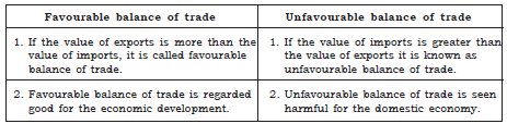
Question : What is unfavourable balance of trade?
Answer : When the value of imports of a country is more than the value of its exports, then it is called as the unfavourable balance of trade.
Question : Which commodities are imported and exported to India?
Answer : Commodities which are imported to India are - petroleum and petroleum products, mineral oil, inorganic chemicals, capital goods, pearls and precious stones. Commodities which are exported by India are - Gems and jewellery, chemical and allied products and engineering good.
Short Answer Type Questions
Question : Why are transport, trade and communication complementary to each other?
Answer : (i) For a long time, trade and transport were restricted to a limited space.
(ii) With the development of science and technology, the area of influence of trade and transport expanded far and wide.
(iii) Today, the world has been converted into a large village with the help of efficient and fast moving transport.
(iv) With the help of an advanced communication system, transport has become even faster in the recent time.
Question : Name the major sea ports of India.
Answer : The major ports of India are :
(i) Kandla Port.
(ii) Mumbai Port.
(iii) The Jawaharlal Nehru Port.
(iv) Marmagao Port.
(v) New Mangalore Port.
(vi) Kochi Port.
(vii) Tuticorin Port.
(viii) Chennai Port.
(ix) Vishakhapatnam.
(x) Paradip Port.
(xi) Kolkata Port.
(xii) Haldia Port.
Question : Evaluate any three features of Golden Quadrilateral Super Highways.
Answer : The main features of the Golden Quadrilateral Super Highways are :
(i) This has been planned to meet the requirement of the fast movement of traffic.
(ii) The government has launched a major road development project linking Delhi-Kolkata- Chennai-Mumbai and Delhi by 6-lane Super Highways.
(iii) The north-south corridor linking Srinagar and Kanyakumari, and east-west corridor connecting Silcher (Assam) and Porbander are parts of this project.
(iv) The major objective of these Super Highways is to reduce time and distance between the mega cities of India. These projects are being implemented by the National Highway Authority of India (NHAI) or metro city.
Question : Why railways are important to India?
Answer : Railways are important to India because they are the primary mode of transportation for goods and people in large quantity and for longer distances. Railways also conduct various activities like business, pilgrimage, sight seeing, etc. Railways help in moulding the economic life of the country and accelerate the development of industries and agriculture. It plays a major role in national integration too.
Question : Name some important ports of India along with their features.
Answer : Kandla in Kachchh, was the first port soon after Independence, Mumbai, the biggest port, Marmagao port of Goa, is the iron ore exporting port of the country, New Mangalore port located in Karnataka caters to the export of iron ore, Kochi, the extreme and south-western port located at the entrance of a lagoon with a natural harbour, south-eastern port, Tuticorin having natural harbour and rich hinterland. Visakhapatnam, is the deepest landlocked and well protected port and Paradwip port located in Odisha, Kolkata, an inland riverine port, are some of the important ports of India.
Question : What are the different types of mail handled by Indian Postal Department?
Answer : There are two different types of mail handled by the Indian Postal Department :
(i) First Class Mail - Cards and envelopes are airlifted between stations covering both land and air.
(ii) Second Class Mail - Includes book packets, registered newspapers and periodicals. These are carried by surface mail, covering land and water transport.
Question : Which port has a natural harbour and how is it useful in terms of trade?
Answer : With a long coastline of 7,516.6 km, India is dotted with 12 major and 200 medium and minor ports. These major ports handle 95% of India's foreign trade.
Moving along the east coast, there is the extreme south-eastern port of Tuticorin in Tamil Nadu which has a natural harbour and rich hinterland. Thus, it has a flourishing trade handling capacity of a large variety of cargoes to even our neighbouring countries like Sri Lanka, Maldives, etc., and the coastal regions of India.
Question : Why air travel today is the fastest, most comfortable and prestigious mode of transport ?
Answer : Air travel today is the fastest, most comfortable and prestigious modes of transport because of certain reasons like :
(i) It can cover very difficult terrains like high mountains, dreary deserts, dense forests and also long oceanic stretches with great ease.
(ii) Travelling in the north eastern part of the country with dense forests and frequent floods and international frontiers, etc. is not possible without air transport.
Question : How many major ports does India have? Name any four points. What is the percentage of foreign trade handled by the major ports?
Answer : India has 12 major ports.
Name of four ports.
(i) Kandla in Kuchchh
(ii) Mumbai port
(iii) Marmagao port (Goa)
(iv) Kochchi port
95% of India’s foreign trade of is handled by the twelve major ports.
Question : Define international trade. Why is it considered as economic barometer of a country?
Answer : When trade takes place between two countries it is known as international trade.
(i) It is very important for the development of a country. Advancement of international trade of a country is an index to its economic prosperity.
(ii) As the resources are space bound, no country can survive without international trade.
(iii) It enables a country to earn foreign exchange which is needed to import essential goods. It is, therefore, considered the economic barometer for a country.
Question : Why have the great plains more railways than the Himalayan mountains?
Answer : The distribution pattern of the railway network in the country has been largely influenced by physiographic, economic and administrative factors. The northern plains provide most favourable conditions having high population density, vast level land, and rich agricultural resources whereas the Himalayan mountainous regions are unfavourable for the construction of railway lines due to high relief, sparse population and lack of economic opportunities. That’s why the great plains have more railways than the Himalayan mountains.
Question : Give one feature of each of the following:
(i) Mumbai port
(ii) Marmagao port
(iii) New Mangalore port
(iv) Tuticorin port
Answer : (i) Mumbai port is the biggest one with a spacious natural and well shelpered harbour.
(ii) Marmago port is the premier iron ore exporting port of the country.
(iii) New Mangalore port, located in Karnataka caters to the export of iron ore concentrates from Kudremukh mines.
(iv) Tuticorin in Tamil Nadu has a natural harbour and rich hinterland.
Question : Explain the reasons for dense railway network in the North Indian plains.
Answer : (i) The northern plains have vast level land. It is easy to lay railway lines there.
(ii) These plains have high population density as a result of which we find dense railway network these to cater the interest of the people.
(iii) Rich agricultural resources provide a favourable condition for the growth of railway network in the northern plains.
(iv) The metropolitan cities of the northern plains have also played a great role in the growth of railways.
Question : What do you mean by the density of the roads? Name the state with
(i) Highest density of roads
(ii) Lowest density of roads
Answer : The length of road per 100 Sq. km of area is known as density of roads.
(i) The state with highest density of roads – Kerala
(ii) The state with lowest density of roads – Jammu & Kashmir.
Question : Which is the principal mode of transportation for freight and passengers?
Answer : The principal mode of transportation for freight and passengers is railways.
Question : Define balance of trade. Distinguish between favourable balance of trade and unfavourable balance of trade.
Answer : The difference between export and import is known as balance of trade.
Question : Mention the importance of tourism as a trade.
Or
What is the importance of tourism?
Answer : Our country earns foreign exchange through tourism. More than 15 million people are directly engaged in the tourism industry. Tourism has proved itself as one of the most important aspects of trade. Tourism in India has grown substantially. It promotes National Integration and provides support to local handicrafts and cultural pursuits.
It also helps in the development of international understanding about our culture and heritage. It has contributed 21,828 crore of foreign exchange in the year 2004. Over 2.6 million foreign tourists visit India every year.
Question : What values are associated with tourism?
Answer : The values associated with tourism are:
(i) It promotes national integration.
(ii) It provides support to local handicrafts and cultural pursuits.
(iii) It develops international understanding among countries.
(iv) It increases foreign exchange.
Question : What is the meaning of road density? Describe any three major problems faced by road transportation in India.
Answer : The length of road per sq km of area is known as road density.
Road transportation in India faces a number of problems. Three of them are given below:
(i) Keeping in view the volume of traffic and passengers, the road network is inadequate.
(ii) About half of the roads are unmetalled and this limits their usage during the rainy season.
(iii) The roadways are highly congested in cities and most of the bridges and culverts are old and narrow.
(iv) The National Highways are inadequate too.
Long Answer Type Questions
Question : Describe the importance of pipelines in India. Name three important networks of pipeline transportation in the country.
Answer : Pipeline transport network is a new arrival on the transportation map of India.
Earlier it was used to transport water but these days it is used for the following:
(i) Transport of crude oil, petroleum products and natural gas from oil and natural gas fields to refineries, fertiliser factories and big thermal power plants is done with the help of pipelines.
(ii) Even solids can be transported through pipelines when converted into slurry.
(iii) The far inland locations of refineries and gas-based fertiliser plants could be thought of only because of pipelines.
(iv) Initial cost of laying pipelines is high but subsequent running costs are minimal.
(v) It rules out trans-shipment (during transportation) losses or delays.
Three important networks of pipeline transportation in the country
(i) From oil field in the upper Assam to Kanpur (UP), via Guwahati, Barauni and Allahabad. It has branches from Barauni to Haldia, via Rajbhand, Rajbhand to Maurigram and Guwahati to Siliguri.
(ii) From Salaya in Gujarat to Jalandhar in Punjab, via Viramgam, Mathura, Delhi and Sonipat. It has branches to connect Koyali (near Vadodara, Gujarat) Chakshu and other places.
(iii) Gas pipeline from Hazira in Gujarat connects Jagdishpur in UP, via Vijaipur in MP. It has branches to Kota in Rajasthan, Shahajahanpur, Babrala and other places in UP.
Question : Write a short note on Indian Railways discussing its importance, distribution pattern and problems faced by the Indian Railways.
Or
How do physical and economic factors influence the distribution pattern of the Indian Railway network? Explain with examples.
Answer : The Indian Railways have a network of 7,031 stations spread over a route length of 63,221 km with a fleet of 7817 locomotives, 5321 passenger service vehicles, 4904 other coach vehicles and 228,170 wagons as on 31 March 2004. The Indian railways is the largest public sector undertaking of India. The first train steamed off from Mumbai to Thane in 1853, covering a distance of 34 km. It is organised into 16 railway zones.
Railways are the prime mode of transportation for goods and passengers in India. Railways also make it possible to conduct varied activities like business, sightseeing and pilgrimage along with transportation of goods over longer distances. They are suitable for long distance travel and play an important role in national integration. Railways in India bind the economic life of the country as well as accelerate the development of the industry and agriculture. The Indian Railways is the largest public sector undertaking in the country. In recent times, the development of the Konkan railway along the west coast has simplified the movement of passengers and goods in this most important economic region of India.
Factors which influence the distribution pattern of Railway network in India:
The distribution pattern of the railway network in the country has been largely influenced by physiographic, economic and administrative factors.
(i) The northern plains provide most favourable condition having high population density, vast level land, and rich agricultural resources.
(ii) Rivers create problem in laying down of railway tracts because they require construction of bridges across the wide beds of the rivers.
(iii) In the hilly terrains of the peninsular region, railway tracts are laid through low hills, gaps or tunnels.
(iv) The Himalayan mountainous regions too are unfavourable for the construction of railway lines due to high relief, sparse population and lack of economic opportunities.
(v) It was equally difficult to lay railway lines on the sandy plain of western Rajasthan, swamps of Gujarat, forested tracks of Madhya Pradesh, Chhattisgarh, Odisha and Jharkhand.
Today, the railways have become more important in our national economy than all other means of transport put together. However, rail transport suffers from certain problems as well.
Problems faced by the Indian Railways
(i) Many passengers travel without tickets.
(ii) Thefts and damaging of railway property has not yet stopped completely.
(iii) People stop the trains, pull the chain unnecessarily and this causes heavy damage to the railway.
Question : Find out the names of the countries connected by Indian Airlines.
Answer : Indian Airlines was one of the best airlines of the world. Before it was merged with Air India in 2007, Indian Airlines covered the following countries :
(i) Nepal
(ii) Bhutan
(iii) Pakistan
(iv) Bangladesh
(v) Thailand
(vi) Malaysia
(vii) Singapore
(viii) Sri Lanka
(ix) Kuwait
(x) Qatar
(xi) UAE (United Arab Emirates)
Question : What are the problems faced by Indian railways?
Answer : (i) Requires huge investment at the time of installation.
(ii) Maintenance and upkeep is very costly.
(iii) Construction is difficult and costly in uneven and high hills and deserts.
(iv) Not suitable for transportation of perishable goods.
(v) Ticket-less travellers.
(vi) Thefts and damaging of railway property.
(vii) Unnecessary chain pulling to stop train.
(viii) Unnecessary conversions.
(ix) Sinking and slipping of tracks in rains.
(x) Modernisation and Electrification.
Question : Give a detailed study of Mass Communication.
Answer : Mass communication provides entertainment and creates awareness among people about various national programmes and policies. It is the means through which one can communicate with several people at the same time.
(i) It includes radio, television, newspapers, magazines, books and films.
(ii) All India Radio (Akash Vani or Voice from the Sky) broadcasts a variety of programmes in national, regional and local languages for various categories of people spread over different parts of the country.
(iii) Doordarshan, the national television channel of India, is one of the largest terrestrial networks in the world.
(iv) Doordarshan broadcasts a variety of programmes from entertainment, educational to sports, etc., for people of different age groups.
Question : In what classes roads are classified in India?
Answer : In India, roads are classified into the following six classes according to their capacity :
(i) Golden Quadrilateral Super Highways : The government has launched a major road development project linking Delhi-Kolkata-Chennai-Mumbai and Delhi by six lane Super Highways.
(ii) National Highways : National Highways link extreme parts of the country. These are the primary road systems and are laid and maintained by the Central Public Works Department (CPWD). The historical Sher Shah Suri Marg is called National Highway No.1, between Delhi and Amritsar.
(iii) State Highways : Roads linking a state capital with different district headquarters are known as State Highways. These roads are constructed and maintained by the State Public Works Department (PWD) in States and Union Territories.
(iv) District Roads : District roads connect the district headquarters with other places of the district. These roads are maintained by the Zila Parishad.
(v) Other Roads : Rural Roads, which link rural areas and villages with towns, are classified under this category.
(vi) Border Roads : Border Roads Organisation, a Government of India undertaking constructs and maintains border roads.
Question : Mention the significance of the railways.
Answer : The significance of railways are enumerated as follows :
(i) Railways have increased the mobility of labour and capital which has contributed to the rapid industrialisation of the country.
(ii) They have helped in the commercialisation of agriculure.
(iii) It is the most commonly used and cost effective long distance transport system.
Source/Case Based Questions
Question : Read the sources given below and answer the questions that follows :
Source A- National Water ways
The Ganga River between Allahabad and Haldia (1620 km)-N.W. No.1. The Brahmaputra river between Sadiya and Dhubri (891 km)-N.W. No.2. The West-Coast Canal in Kerala Kottapurma-Kollam, Udyogamandal and Champakkara canals-205 km) — N.W. No.3. Specified stretches of Godavari and Krishna rivers along with Kakinada Puducherry stretch of canals (1078 km) — N.W. No.4. Specified stretches of river Brahmani along with Matai river, delta channels of Mahanadi and Brahmani rivers and and East Coast Canal (588 km) – N.W. No.5
Source B- Roadways
India has one of the largest road networks in the world, aggregating to about 54.7 lakh km. In India, roadways have preceded railways. They still have an edge over railways in view of the ease with which they can be built and maintained. The growing importance of road transport vis-à-vis rail transport is rooted in the following reasons; (a) construction cost of roads is much lower than that of railway lines, (b) roads can traverse comparatively more dissected and undulating topography, (c) roads can negotiate higher gradients of slopes and as such can traverse mountains such as the Himalayas, (d) road transport is economical in transportation of few persons and relatively smaller amount of goods over short distances, (e) it also provides door-to-door service, thus the cost of loading and unloading is much lower.
(i) What is the stretch of National Waterways No. 3?
Answer : The West-Coast Canal in Kerala (Kottapurma-Kollam, Udyogamandal and Champakkara canals-205 km) - N.W. No.3.
(ii) Why is the construction cost of roads is much lower than that of railway lines?
Answer : The construction cost of roads is much lower than that of railway lines because roads can traverse comparatively more dissected and undulating topography.
Question : Start your search vertically, horizontally or diagonally and reach various destinations across the countries!

Answer : 1. SHERSHAH SURI MARG
2. CHENNAI
3. BROADGAUGE
4. MUGHALSARAI
5. KOLKATA
6. SRINAGAR
7. KANYAKUMARI
SUMMARY:
♦ Importance of roads : Low construction and maintenance cost → Suitable to all areas→ Economical in the transportation of few goods and persons→ Provides door-to -door
service→ Reduces transportation cost→ Works as a linking force to other means of transportation→ Very suitable to short and medium distances→ For perishable goods road
provide better service
♦ Problems of road transportation in India : Road network is inadequate → Poor condition of Indian roads→ Damaged and unmetalled roads Roads are highly congested in cities→ Lack of related services like ambulances and telephone services
♦ Classification of Indian roads: Golden quadrilateral super highway(Delhi-Kolkata-Chennai- Mumbai-Delhi) (NHAI)East-west corridor-(silcher Assam-porbandhar Gujarat) North- South corridor (Kashmir - kanyakumari)Main aim is to reduce time and distance between mega cities of India National highway-primary road system of our country (CPWD) State highways-- -linking state capital with district head quarters(state PWDs) District roads--linking district headquarters with other places(district panchayat or zila parishad) Border roads—roads of border areas of the country (Border Roads Organization)BRO Other roads---roads linking cities and villages(local self government like panchayat)
♦ Importance of Railway: 1) Railway carry most of the long distance passengers→80% of total goods are transported through Railway 2) Many industries are depending on railway for transportation of raw-materials and finished goods 3) Provides employment to more than million people →Provide Mail service 4) integrating the country by bringing different
people and regions together 5) Supports economic development
♦ Problems faced by Indian Railway: Passengers travelling without tickets →Theft and damages→ Delay of trains→poor condition.
♦ Qualitative improvements made to Indian railway : Introduced electric engines instead of steam engine →electrification of railway tracks, Computerized reservation of tickets→ more faster trains services→ METRO→ AC coaches
♦ Importance of pipeline transportation Very suitable for petroleum products, thermal plants and gases→safe &fast way of transportation→
♦ Mumbai- largest seaport with a spacious and well sheltered harbor
♦ Kandla -first port developed after independence→handling export and import of industrial goods and food
♦ New Mangalore- handling mainly export of iron and steel industry(karnataka)
♦ Kochi- extreme south west port with a natural harbor (kerala)
♦ Marmagao- it is the premier iron ore exporting port (Goa)
♦ Tuticorin- natural port with rich hinterland at the south east, handling export to our neighboring countries
♦ Chennai-old & second largest port of India and (Tamil Nadu)
♦ Vishakapattinam-deepest landlocked and well protected port of India (Andra Pradesh)
♦ Paradip- specialized in iron ore export(Orissa)
♦ Kolkata-riverine port with a large and rich hinterland (West Bengal)
♦ Haldia-a subsidiary port of kolkatta (West Bengal)
♦ Fast growing sector (26%growth rate) →World’s largest postal service →largest telephone network in
♦ Economic development of a country depends upon transport and communication →they link areas of Production and areas of consumption→ they link between different sectors of economy→they lead to regional development
Question. What does necessitate the need for transport?
Answer: The movement of goods and services from their supply locations to demand locations necessitates the need for transport .
Question. Why is the efficient means of transport pre-requisites for fast development?
Answer: The pace of development of a country depends upon the production of goods and services as well as their movement over space. Therefore, efficient means of transport are pre-requisites for fast development.
Question. How is transport, communication and trade are complementary to each other?
Answer: 1. With the development in Science and technology, the area of influence of trade and transport expanded far and wide.
2. Today, the world has been converted into a large village with the help of efficient and fast moving transport.
3. Transport has been able to achieve this with the help of equally developed communication system.
Question. Name the factors that are contributing to India’s Socio-economic progress.
Answer: Railways, airways, waterways, newspapers, radio, television, cinema and Internet, etc. have been contributing to its socio-economic progress in many ways.
Question. Give reasons for the growing importance of roadways vis-a vis rail transport in India?
Answer: The growing importance of road transport vis-à-vis rail transport is rooted in the following reasons:
1. Construction cost of roads is much lower than that of railway lines.
2. Roads can traverse comparatively more dissected and undulating topography.
3. Roads can negotiate higher gradients of slopes and as such can traverse mountains such as the Himalayas.
4. Road transport is economical in transportation of few persons and relatively smaller amount of goods over short distances.
5. It also provides door-to-door service, thus the cost of loading and unloading is much lower.
6. Road transport is also used as a feeder to other modes of transports such as they provide a link between railway stations, air and seaports.
Question. What are Golden Quadrilateral Super Highways?
Answer: State its major objective? Who maintain and implement these highways.
1. The government has launched a major road development project linking Delhi-Kolkata-Chennai-Mumbai and Delhi by six-lane Super Highways.
2. The North-South corridors linking Srinagar (Jammu & Kashmir) and Kanyakumari (Tamil Nadu), and East-West Corridor connecting Silcher (Assam) and Porbander (Gujarat) are part of this project.
3. The major objective of these Super Highways is to reduce the time and distance between the mega cities of India.
4. The National Highway Authority of India (NHAI) implements and maintain.
Question. Explain any two characteristics of National Highways. Name the two cities linked by the National Highway No.1.
Answer: 1. National Highways link extreme parts of the country.
2. These are the primary road systems and are laid and maintained by the Central Public Works Department (CPWD).
3 The historical Sherhah Suri Marg is called National Highway No.1, linking Delhi and Amritsar.
Question. What are State Highways? Who maintains these roads?
Answer: 1. Roads linking a state capital with different district headquarters are known as State Highways.
2. These roads are constructed and maintained by the State Public Works Department (PWD) in State and Union Territories.
Question. What are District Roads? Who maintains these roads?
Answer: 1. These roads connect the district headquarters with other places of the district.
2. The Zila Parishad maintains these roads.
Question. What are Rural roads? What special impetus these roads have received?
Answer: 1. These roads link rural areas and villages with towns.
2. These roads have received special impetus under the Pradhan Mantri Grameen Sadak Yojana.
3. Under this scheme special provisions are made so that every village in the country is linked to a major town in the country by an all season motorable road.
Question. Describe the Boarder Roads of India.
Answer: 1. Border Roads Organisation a Government of India undertaking constructs and maintains roads in the bordering areas of the country.
2 This organisation was established in 1960 for the development of the roads of strategic importance in the northern and north-eastern border areas. 3 These roads have improved accessibility in areas of difficult terrain and have helped in the economic development of these areas.
Question. How are Indian roads classified?
Answer: According to capacity- roads are classified –Golden Quadrilateral Super Highways, National Highways, State Highways, State Highways, District, other Roads-rural roads and Border roads.
According to the type of material used for their construction-Metalled and Unmetalled.
Question. Differentiate between Metalled and Unmetalled Roads.
Answer: A) Metalled roads: i)Metalled roads may be made of cement, concrete or even bitumen of coal,
ii) They are all weather roads.
B) Unmetalled roads: i) They are made up of mud, wood etc.
ii) These roads go out of use in the rainy season.
Question. What is the density of road? What is the road density in India.
Answer: The length of road per 100 sq. km of area is known as density of roads. Distribution of road is not uniform in the country. Density of all roads varies from only 10 km in Jammu & Kashmir to 375 km in Kerala with the national average of 75 km (1996-97).
Question. What are the problems faced by the Road Transportation in India?
Answer: 1. Keeping in view the volume of traffic and passengers, the road network is inadequate.
2. About half of the roads are unmetaled and this limits heir usage during the rainy season.
3. The National Highways are inadequate too.
4. Moreover, the roadways are highly congested in cities.
5. Most of the bridges and culverts are old and narrow.
Question. Give the importance of Railways in India.
Answer: 1. Railways are the principal mode of transportation for freight and passengers in India.
2. Railways also make it possible to conduct multifarious activities like business, sightseeing, and pilgrimage along with transportation of goods over longer distances.
3. Apart from an important means of transport he Indian Railways has been a great integrating force for more than 150 years.
4. Railways in India bind the economic life of the country.
5. Railways accelerate the development of the industry and agriculture.
Question. Explain the physiographic, economic and administrative factors that influence the network of Indian railways.
Answer: A) Physiographic factors:
a) Northern plains: Northern plains are vast level land. It provides the most favourable conditions to lay down railway tracks.
b) Peninsular region: In the hilly terrains of the Peninsular region railways tracks are laid through low hill gaps, which increased the cost of construction of railways tracks.
c) High relief and sparse population The Himalayan mountainous regions are unfavourable for the construction of railway lines due to high relief and sparse population.
d) Desert region: The desert region of western Rajasthan does not allow to develop railway lines in the region.
e) Other areas and difficulty in construction of railways: The swamps of Gujarat, forested tracks of Madhya Pradesh, Chhasttisgarh, Orissa and Jharkhand are also not suited to construct railway lines.
B) Economic and Administrative factors:
1. Railways are the principal mode of transportation for freight and passengers.
2. Northern plains have high density of population and rich agricultural resources.
3. Plateau region of Chhotanagpur is rich in mineral resources. As a result railway tracks are spread over the region.
4. Industrial regions of the country directly linked with railway lines.
5. Administrative factors: Due to the vastness of the country the railway has been divided in 16 different railway zones. This help managing the railways.
OR
Question. Why is Northern Plain has well-developed Railway network?
Answer: 1. The northern plains with their vast level land, high population density and rich agricultural resources provided the most favourable condition for their growth.
2. However, a large number of rivers requiring construction of bridges across their wide beds posed some obstacles.
Question. Why is Himalayan Regions unfavourable for the construction of Railways?
Answer: Due to unfavourable for the construction of railway lines due to high relief, sparse population and lack of economic opportunities.
Question. What is the importance of Konkan Railway in South India? What are the problems faced by the network?
Answer: a) In recent times, the development of the Konkan railway along the west coast has facilitated the movement of passengers and goods in this most important economic region of India.
b) It has also faced a number of problems such as sinking of track in some stretches and land slides.
Question. What are the problems of Indian Railways?
Answer: 1. Many passengers travel without tickets.
2. Thefts and damaging of railway property has not yet stopped completely.
3. People stop the trains, pull the chain unnecessarily and this causes heavy damage to the railway.
Question. What is the role-played by Pipelines in the development of the country?
Answer: 1. Pipeline transport network is a new arrival on the transportation map of India. In the past, these were used to transport water to cities and industries.
2. Now, these are used for transporting crude oil, petroleum products and natural gas from oil and natural gas fields to refineries, fertilizer factories and big thermal power plants.
3. Solids can also be transported through a pipeline when converted into slurry.
4. The far inland locations of refineries like Barauni, Mathura, Panipat and gas based fertilizer plants could be thought of only because of pipelines.
Question. Give any two positive points of pipeline transportation. Explain the three important networks of pipelines transportation in the country. Positive aspects:
Answer: 1. Initial cost of laying pipelines is high but subsequent running costs are minimal.
2. It rules out trans-shipment losses or delays.
Important network of pipelines:
1. From oil field in upper Assam to Kanpur (Uttar Pradesh), via Guwahati, Barauni and Allahabad. It has branches from Barauni to 85 important economic regions of India. It has also Haldia, via Rajbandh, Rajbandh to Maurigram and Guwahati to Siliguri.
2. From Salaya in Gujarat to Jalandhar in Punjab, via Viramgam, Mathura, Delhi and Sonipat. It has branches to connect Koyali near Vadodara, Gujarat) Chakshu and other places.
3. Gas pipeline from Hazira in Gujarat connects Jagdishpur in Uttar Pradesh, via Vijaipur in Madhya Pradesh. It has branches to Kota in Rajasthan, Shahajahanpur, Babrala and other places in Uttar Pradesh.
Question. Give any three advantages of waterways.
Answer: 1. Waterways are the cheapest means of transport.
2. They are most suitable for carrying heavy and bulky goods.
3. It is a fuel-efficient and environment friendly mode of transport
Question. Name the three waterways declared as National Highways by the Government.
Answer: 1. The Ganga river between Allahabad and Haldia (1620 km)- N.W. No.1.
2. The Brahmaputra river between Sadiya and Dhubri (891 km)-N.W. No.2.
3. The West-Coast Canal in Kerala (Kottapurma-Komman, Udyogamandal and Champakkara canals-205 km) – N.W. No.3.
Question. State the significance of sea ports to development of trade in India
Answer: India’s trade with foreign countries is carried from the ports located along the coast. That constitutes 95 per cent of the country’s trade volume.
Question. Describe the importance of Kandla Port
Answer: 1. Kandla in Kuchchh was the first port developed soon after Independence to ease the volume of trade on the Mumbai port, in the wake of loss of Karachi port to Pakistan after the Partition.
2. Kandla is a tidal port.
3. It caters to the convenient handling of exports and imports of highly productive granary and industrial belt stretching across the states of Jammu and Kashmir, Himachal Pradesh, Punjab, Haryana, Rajasthan and Gujarat.
Question. Why was Haldia port developed?
Answer: Haldia port was developed as a subsidiary port, in order to relieve growing pressure on the Kolkata port.
Question. Give the importance of Tuticorin Sea Port.
Answer: 1. Moving along the east coast, the extreme south-eastern part lies the port Tuticorin, in Tamil Nadu.
2. This port has a natural harbour and rich hinterland.
3. Thus, it has a flourishing trade handling of a large variety of cargoes to even our neighbouring countries like Sri Lanka, Maldives, etc. and the coastal regions of India.
Question. Give reason why Kolkata port requires constant dredging of Hoogly River?
Answer: Being a tidal port, it requires constant dredging of Hoogly. (As the river bed gets filled with the sediments)
Question. Explain the significance of airways. Why is air travel preferred in the North –east states of India? Significance of airways:
Answer: 1. The air travel, today, is the fastest, most comfortable and prestigious mode of transport.
2. It can cover very difficult terrains like high mountains, dreary deserts, dense forests and also long oceanic stretches with great ease.
3. Air travel has made access easier to the north-eastern part of the country, marked with the presence of big rivers, dissected relief, dense forests and frequent floods and international frontiers, etc.
Air travel in the North-east: Air travel has made access easier to the north-eastern part of the country, marked with the presence of big rivers, dissected relief, dense forests and frequent floods and international frontiers, etc.
Question. Explain the role played by Pawanhans Helicopters Ltd in the transport Services.
Answer: Pawanhans Helicopters Ltd. provides helicopter services to Oil and Natural Gas Commission in its off- shore operations, to inaccessible areas and difficult terrains like the north-eastern states and the interior parts of Jammu and Kashmir, Himachal Pradesh and Uttaranchal.
Question. Explain the changes that took place in the means of communication.
Answer: 1. Long distance communication is far easier without physical movement of the communicator or receiver.
2. Personal communication and mass communication including television, radio, press; films, etc. are the major means of communication in the country.
Question. Explain the role-played the Indian Postal network in the communication fields. Also explain the two types of mails that Indian postal network handles. What has been done to facilitate quick delivery of mails?
Answer: 1. The Indian postal network is the largest in the world. It handles parcels as well as personal written communications.
2. First Class Mail:
a) Cards and envelopes are considered first–class mail.
b) They are airlifted between stations covering both land and air.
3. Second Class Mail:
a) It includes book packets, registered newspapers and periodicals.
b) They are carried by surface mail, covering land and water transport.
4. To facilitate quick delivery of mails in large towns and cities, six mail channels have been introduced recently. They are called Rajdhani Channel, Metro Channel, Green Channel, Business Channel, Bulk Mail Channel and Periodical Channel.
Question. What are the steps taken by the government in order to strengthen the flow of information from the grassroots to the higher level?
Answer: 1. To strengthen the flow of information from the grassroot to the higher level, the government has made special provision to extend twenty-four hours STD facility to every village in the country.
2. There is a uniform rate of STD facilities all over India.
3. It has been made possible by integrating the development in space technology with communication technology.
Question. Give four examples of Mass communication. What is the role-played by it?
Answer: It includes radio, television, newspapers, magazines, books and films.
Mass communication provides entertainment and creates awareness among people about various national programmes and policies.
Question. Write a brief note on: All India Radio (Akashwani)
Answer: All India Radio (Akashwani) broadcasts a variety of programmes in national, regional and local languages for various categories of people, spread over different parts of the country.
Role-played by the Doordarshan in the field of communication
a) Doordarshan, the national television channel of India, is one of the largest terrestrial networks in the world.
b) It broadcasts a variety of programmes from entertainment, educational to sports, etc. for people of different age groups.
Question. What is trade and market? Give various types of trade.
Answer: 1. The exchange of goods among people, states and countries is referred to as trade.
2. The market is the place where such exchanges take place.
3. Trade between two countries is called international trade. It may take place through sea, air or land routes.
4. Local trade is carried in cities, towns and villages.
5. State level trade is carried between two or more states.
Question. Why is the International Trade considered as the Economic barometer for a country? Also name the components of international trade.
Answer: A) Advancement of international trade of a country is an index to its economic prosperity. Therefore International Trade considered as the Economic barometer for a country.
B) Export and import are the components of International trade.
Question. Explain the balance of trade, favourable and unfavourable balance of trade.
Answer: 1. The balance of trade of a country is the difference between its export and import.
2. When the value of export exceeds the value of imports, it is called a favourable balance of trade.
3. On the contrary, if the value of imports exceeds the value of exports, it is termed as unfavourable balance of trade.
Question. Name the items of export.
Answer: Among the commodities of export, whose share has been increasing over the last few years till 2004-05 are agriculture and allied products, ores and minerals, gems and jewellery, chemical and allied products, engineering goods and petroleum products.
Name the items of import. Petroleum and petroleum products, pearls and precious stone, inorganic chemicals, coal, coke and briquettes, machinery, fertilizers, cereals, edible oil and newsprint.
Question. “International Trade has under gone a sea change in the last fifteen years”. Explain.
Answer: 1. International trade has undergone a sea change in the last fifteen years.
2. Exchange of commodities and goods has been superseded by the exchange of information and knowledge.
3. India has emerged as software giant at the international level and it is earning large foreign exchange through the export of information technology.
Question. What is the importance of tourism in the development of the country?
Answer: 1. It contributes for foreign exchange of our country.
2. More than 15 million people are directly engaged in the tourism industry.
3. Tourism also promotes national integration, provides support to local handicrafts and cultural pursuits.
4. It also helps in the development of international understanding about our culture and heritage.
5. Foreign tourists visit India for heritage tourism, eco tourism, adventure tourism, cultural tourism, medical tourism and business tourism.
Question. Name the important destinations of foreign tourists in India.
Answer: Rajasthan, Goa, Jammu and Kashmir and temple towns of south India are important destinations of foreign tourists in India.
Question. Why that is in North-eastern states and interior parts of Himalayas, tourism has been neglected?
Answer: There is vast potential of tourism development in the north-eastern states and the interior parts of Himalayas, but due to strategic reasons these have not been encouraged so far.
Question. The means of transportation, communication and trade are considered as the lifelines of the country. Justify giving five examples.
Answer: Reasons:
a) Economic development- They help building the infrastructure for the country. This brings economic progress in the form of roads, dams, buildings etc.
b) Trade- Trade is extremely important for the country. The means of transportation help the goods and services exchanged from one region to another.
c) Social progress- These means help building up the social infrastructure in the form of hospitals, schools, parks etc.
d) Achieving higher standard of living: The availability of efficient network of transport and communication ensures better living standard as goods and services across the global are available for use such as cars, mobile phone, software programmes, amenities etc. This brings change in the lives of the people.
e.) Awareness, entertain and knowledge: The means of communication makes it possible to update and inform the citizen about the changes taking place in and outside the country. Hence, the people come to know about the programmes and policies of the government.
Free study material for Social Science
CBSE Social Science Class 10 Contemporary India Chapter 7 Lifelines of National Economy Worksheet
Students can use the practice questions and answers provided above for Contemporary India Chapter 7 Lifelines of National Economy to prepare for their upcoming school tests. This resource is designed by expert teachers as per the latest 2026 syllabus released by CBSE for Class 10. We suggest that Class 10 students solve these questions daily for a strong foundation in Social Science.
Contemporary India Chapter 7 Lifelines of National Economy Solutions & NCERT Alignment
Our expert teachers have referred to the latest NCERT book for Class 10 Social Science to create these exercises. After solving the questions you should compare your answers with our detailed solutions as they have been designed by expert teachers. You will understand the correct way to write answers for the CBSE exams. You can also see above MCQ questions for Social Science to cover every important topic in the chapter.
Class 10 Exam Preparation Strategy
Regular practice of this Class 10 Social Science study material helps you to be familiar with the most regularly asked exam topics. If you find any topic in Contemporary India Chapter 7 Lifelines of National Economy difficult then you can refer to our NCERT solutions for Class 10 Social Science. All revision sheets and printable assignments on studiestoday.com are free and updated to help students get better scores in their school examinations.
FAQs
You can download the latest chapter-wise printable worksheets for Class 10 Social Science Contemporary India Chapter 7 Lifelines of National Economy for free from StudiesToday.com. These have been made as per the latest CBSE curriculum for this academic year.
Yes, Class 10 Social Science worksheets for Contemporary India Chapter 7 Lifelines of National Economy focus on activity-based learning and also competency-style questions. This helps students to apply theoretical knowledge to practical scenarios.
Yes, we have provided solved worksheets for Class 10 Social Science Contemporary India Chapter 7 Lifelines of National Economy to help students verify their answers instantly.
Yes, our Class 10 Social Science test sheets are mobile-friendly PDFs and can be printed by teachers for classroom.
For Contemporary India Chapter 7 Lifelines of National Economy, regular practice with our worksheets will improve question-handling speed and help students understand all technical terms and diagrams.