

Chapter-wise Worksheets for Class 4 Social Science: Political Map Of India
Explore structured practice materials through the CBSE Class 4 Social Studies Political Map Of India Worksheet Set 01. Tailored for Class 4 learners, utilizing these Social Science worksheets ensures thorough preparation and strengthens problem-solving accuracy before final school evaluations.
Practice Class 4 Social Science Worksheets: Political Map Of India
Access the complete worksheet PDF for Class 4 Social Science below. Regular practice with these targeted academic tasks builds familiarity with standard question patterns and helps secure higher marks in final school examinations.
India is located in the southern part of the continent of_______.
• It is the________ largest country in the world in area and the
second largest in _________.
• The southernmost tip of India is _________.
• The smallest state of India is ________.
• It is surrounded by the water bodies: ___________ in the west,
the _________ in the east and the _______ in the south.
• Today, India is a union of __________ states and
_________union territories.
• Chandigarh is the capital city of two states___________ and _____________.
I. Write “True” if the statement is correct and “False” if the statement is incorrect.
Ans-
More questions-
I FILL IN THE BLANKS.
1. ______ stands for truth, knowledge and wealth.
2. The wheel stands for ___________ and ____________.
3. In a village, _____________ provides civic amenities to the people.
4. The Municipal Committees collect money through ____________.
5. _________ Soil develops as a result of leaching.
6. ________ is a fertilizer formed from dead leaves and plants in the soil.
7. ________ is the top layer of the earth’s surface in which plant’s grow.
8. ___________ is a structure with long arms called sails, used to change the power of wind into electricity.
9. _________ and ___________ are added to the soil to increase its fertility.
10. ____________ is the money paid to use a road or a bridge.
A. Tick the correct answer:-
1. For nearly how many years did Akbar rule?
a. 5 years b. 10 years c. 20 years d. 50 years
2. Whom did Akbar defeat at the second battle of Panipat?
a. Chand bibi b. Rani Durgavati c. Hemu d. Maharana pratap
3. Which of these is a religious path suggested by Akbar?
a. Din-i-Illahi b. Buddhism c. Judaism d. Christianity
B. Rearrange the letters:-
1. J A A AR R L B B I A _________________
2. A L U B A Z F L _________________
3. A R A J D O R A T A M L __________________
4. N M I A N S T N E A __________________
5. R J A A N M A G S N H I ___________________
C. Mark these places on Indian Political map:-
1. Assam
2. Andhra Pradesh
3. Bihar
4. Chattisgarh
5. Goa
6. Gujarat
7. Jharkhand
8. Karnataka
Question. Green colour is used to show :
a) Township
b) Vegetation
c) Urban areas
Answer : B
Question. Blue colour is use to show :
a) Forest
b) Urban areas
c) Water bodies
Answer : C
Question. A scale is necessary :
a) For a map
b) For a sketch
c) For symbols
Answer : A
Question. A political maps shows :
a) Mountains
b) Countries and Capitals
c) Population
Answer : B
Question. Most maps are drawn with north located at the :
a) Top
b) Left
c) Right
Answer : A
Fill in the blanks :
Question. The first person who published a collection of maps was _______ .
Answer : Gerardus Mercator
Question. A compass rose shows the four ______ directions.
Answer : cardinal
Question. Maps are easier to ______ than globes.
Answer : carry
Question. A map legend provides keys to all ______ .
Answer : symbols
Question. A thematic map focuses on a particular ______ .
Answer : theme
Very Short Answer Type Questions :
Question. What is meant by the language of a map?
Answer : A number of signs, symbols and colours are used for showing different things on map is known as the language of map.
Question. What are the features that help us to read a map?
Answer : Compass rose, scale, symbols and colours are the features that help us to read a map.
Question. What is an atlas?
Answer : A book of maps is called an atlas.
Question. What are four cardinal directions?
Answer : The four cardinals directions are - East, West, North and South.
Question. What do map symbols represent ?
Answer : Map symbols are used to represent real objects of the world on maps.
Short Answer Type Questions :
Question. How are maps more helpful than a globe?
Answer : Maps are more helpful than a globe because maps provide more information than a globe. A globe an be useful when we want to study about the whole earth. But when we want to study only a part of the earth, as about a country or a state then maps are more useful.
Question. Define plan.
Answer : A plan is usually a detailed diagram or map of a town, a group of buildings etc. It may present an outline drawing of a building or structure, showing the position and size of the various parts in relation to each other.
Question. Define a thematic map.
Answer : A thematic map is a map that focuses on a particular theme or special topic in an area, such as annual rainfall, population, density, soils, crops, industries etc.
Question. How does a scale help in map reading?
Answer : The scale of a map tells us the relationship between distances on the map and those on the ground. Thus, the scale of a map is the ratio of a distance on the map to the corresponding distance on the ground.
Long Answer Type Questions :
Question. What is a map? How do maps help us ?
Answer : Maps : A map is a representation of the Earth's surface or a part of it on a flat surface. It shows countries, rivers, mountains, oceans, roads etc.
Uses of maps :
• Maps help us to know locations of various features of the Earth and estimate distances between places.
• Maps also help us to compare sizes of countries and states and routes to various places.
Question. Draw the symbols to show the following :
Answer :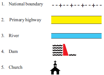
I. Circle the odd one out:
1. Pakistan Nepal Bihar China
2. Badrinarth Kedarnath Gangotri Kerela
3. Garo Mt. Everest Khasi Naga
4. Chandigarh Puducherry Lakshadweep Punjab
II. Answer these :
1. People of Kashmir drink a special type of tea : __________________________
2. The coastline of the mainland India is : ___________________________
3. Main festival of Bihar : ___________________________
4. Two folk dances of Punjab : ___________________________
5. Two places of tourist attraction of Kashmir : ___________________________
6. Land of hill People : ____________________________
III. Identify the pictures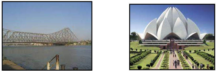
IV. On the political map of India Mark the following States and their Capitals.
1. Punjab
2. National Capital Territory Of Delhi
3. Uttar Pradesh
4. Bihar
5. West Bengal
6. Assam
7. Tripura
A. Tick the correct answer:-
1. Which of these is not a civic amenity?
a. Electricity b. roads c. drinking water d. bungalow
2. Which of these cities does not have a municipal corporation?
a. Mumbai b. Shilong c. Kolkata d. Delhi
3. After how years are the municipal elections held?
a. 1year b. 3 years c. 5 years d. 10 years
4. Who heads the municipal corporation?
a. Chairperson b. President c. Mayor d. Deputy mayor
5. Which of these taxes is not imposed by the local self governing bodies?
a. Road tax b. Water tax c. Property tax d. Income tax
B. Write two examples of each:-
1. Public utility services ________________ ______________
2.Local self government ________________ ______________
3. Names given to municipal committee ________________ ______________
4. Cities which have municipal corporations ________________ ______________
5. Taxes collected by a local governing body ______________ ________________
C. Match the columns:-
1. Municipal committee a. civic amenity
2. Municipal councillor b. after every five years
3. Drinking water c. member of a municipal committee
4. Municipal election d. local government body of a village
A. New words ( Write these words twice):-
1. Temperature
2. Rainfall
3. Monsoon
4. Western disturbance
5. Loo
6. Dust storms
7. Plums
8. Breeze
9. Mawsynram
10. Weather
B. Define the words:-
Drought:- a long period of dry weather with very little or no rain
Moisture:- here, water vapour
C. Answer these questions:-
Q-1. What is the difference between weather and climate?
Answer : Weather changes every day. Climate remains the same for years.
Q-2. What role do the western disturbances play?
Answer : Western disturbances cause light rainfall in the plains and snowfall in the northern Mountains.
Q-3. How are monsoon winds useful?
Answer : The monsoon winds blow from the Arabian Sea and the Bay of Bengal towards the land.
While passing through the seas they pick up lot of moisture. This moisture causes rainfall.
Q-4. Which state in India receives the highest rainfall? Which state receives the lowest rainfall?
Answer : In India Meghalaya receives the highest rainfall. Rajasthan receives the lowest rainfall.
Download Class 4 Social Science Political Map Of India Practice Worksheets
Daily Practice Questions for Class 4 Social Science
Explore reliable practice questions for Political Map Of India tailored for Class 4 Social Science learners. Use these structured worksheets to evaluate exam preparedness and strengthen problem-solving skills throughout the 2026 academic session.
Detailed Answers for Class 4 Social Science Political Map Of India
Designed around the official curriculum for Class 4 Social Science, these practice sheets guarantee standard compliance. Reviewing step-by-step solutions after completion sharpens your accuracy and clarifies complex sub-topics within Political Map Of India.
Complete Your Chapter Revision
Consistent engagement with these exercises builds familiarity with recurring exam themes. If specific areas within Political Map Of India cause trouble, utilize our dedicated NCERT solutions for Class 4 Social Science to clear up doubts immediately.
FAQs
You can download the latest chapter-wise printable worksheets for Class 4 Social Science Political Map Of India for free from StudiesToday.com. These have been made as per the latest CBSE curriculum for this academic year.
Yes, Class 4 Social Science worksheets for Political Map Of India focus on activity-based learning and also competency-style questions. This helps students to apply theoretical knowledge to practical scenarios.
Yes, we have provided solved worksheets for Class 4 Social Science Political Map Of India to help students verify their answers instantly.
Yes, our Class 4 Social Science test sheets are mobile-friendly PDFs and can be printed by teachers for classroom.
For Political Map Of India, regular practice with our worksheets will improve question-handling speed and help students understand all technical terms and diagrams.