
Read and download the CBSE Class 6 Social Science Latitudes And Longitudes Worksheet in PDF format. We have provided exhaustive and printable Class 6 Social Science worksheets for The Earth our Habitat Chapter 2 Globe Latitudes and Longitudes, designed by expert teachers. These resources align with the 2026-27 syllabus and examination patterns issued by NCERT, CBSE, and KVS, helping students master all important chapter topics.
Chapter-wise Worksheet for Class 6 Social Science The Earth our Habitat Chapter 2 Globe Latitudes and Longitudes
Students of Class 6 should use this Social Science practice paper to check their understanding of The Earth our Habitat Chapter 2 Globe Latitudes and Longitudes as it includes essential problems and detailed solutions. Regular self-testing with these will help you achieve higher marks in your school tests and final examinations.
Class 6 Social Science The Earth our Habitat Chapter 2 Globe Latitudes and Longitudes Worksheet with Answers
Topic- GLOBES AND MAPS
Fill in the blanks :
Question. A _____ is used to find the main directions.
Answer : compass
Question. ______ colour is used for showing mountains.
Answer : Brown
Question. The blue colour is used for showing ________.
Answer : water bodies
Question. A globe can be useful when we want to study the earth as a _____.
Answer : whole
True/False :
Question. A scale is necessary for a map.
Answer : True
Question. Globe is a miniature form of Earth.
Answer : True
Question. Direction is not a component of maps.
Answer : False
Question. A physical map shows natural features of the earth.
Answer : True
Very Short Answer Type Questions :
Question. What are intermediate directions?
Answer : The four intermediate directions are north-east (NE), southeast (SE), south-west (SW) and north-west (NW).
Question. Which map shows distribution of forests?
Answer : Thematic map shows distribution of forests.
Question. What is Compass?
Answer : It is an instrument used to find out main directions. Its magnetic needle always points towards north-south direction
Question. What is an Atlas?
Answer : When many maps are put together we get an Atlas.
Question. Which map provides detailed information?
Answer : Thematic maps provide detailed information.
Question. What do you mean by the term ‘the scale of the map’?
Answer : Scale is the ratio between the actual distance on the ground and the distance shown on the map.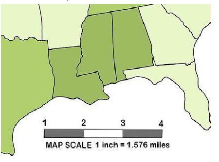
Question. What are the three components of a map?
Answer : There are three Components of Maps – distance, direction and symbol.
Short Answer Type Questions :
Question. How do symbols help in reading maps?
Answer : Symbols give a lot of information in a limited space. With the use of these symbols, maps can be drawn easily and are simple to read. Even if we don’t know the language of an area and therefore cannot ask someone for directions, we can collect information from maps with the help of these symbols. Maps have a universal language that can be understood by all.
Question. Distinguish between a map and a plan.
Answer : Difference between a map and a plan
Map :
• A map is a representation or a drawing of the earth’s surface or a part of it drawn on a flat surface according to a scale.
Plan :
• A plan is a drawing of a small area on a large scale.
Question. How are maps more helpful than a globe?
Answer : A globe can be useful when we want to study the earth as a whole but when we want to study only a part of the earth, as about our country, states, districts, towns and villages, it is of little help. In such a situation we use maps.
Question. What is a sketch map?
Answer : A sketch is a drawing mainly based on memory and spot observation and not to scale. Sometimes a rough drawing is required of an area to tell where a particular place is located with respect to other places. Such a rough drawing is drawn without scale, and is called a sketch map.
Question. Differentiate between small scale map and large scale map.
Answer : Difference between small scale map and large scale map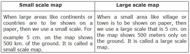
I. CHOOSE THE CORRECT ANSWER:-
1. The Arctic Circle is located in (Southern hemisphere, Northern hemisphere, Eastern hemisphere)
2. The earth moves from to (East to West, West to East, South to North)
3. help us to calculate time. (Latitudes, Longitudes, Equator)
4. The standard meridian of India is (82 1/2° N, 82 1/2° S, 82 1/2° E)
5. The total number of Latitudes are (360, 180, 90)
6. Parallels of Latitude help in determining (time climate, places)
7. Grid is a network of (Parallels of Latitude and Meridians of Longitude, the Tropic of Cancer and Tropic of Capricorn, the North pole and the South pole)
8. zone receives moderate temperature. (Torrid Zone, Frigid Zone, Temperate Zone)
9. The Frigid Zone is near (Tropic of Cancer, equator, poles)
10. Latitudes are parallel lines north and south of the (Equator, Prime Meridian, North pole)'
II. FILL IN THE BLANKS:-
1. ..................... is the true shape of the earth.
2. ..................... represents the zero degree latitude.
3. The value of Prime Meridian is .....................
4. The Tropic of Cancer is located in .....................
5. ..................... are equal in length.
6. The area which receives maximum heat is .....................
7. Russia has ..................... number of standard times.
8. The latitude parallel to the equator at 23 1/2° N is called .....................
9. ..................... is the longest parallel of latitude.
10. The earth has been divided into ..................... time zones of one hour each
<1M>
1.India lies between which longitudes?
(A) 68° E to 97 °E
(B) 68°W to 97°W
(C) 68° S to 97° S
(D) 68° N to 97° N
2.Name the two basic points of reference on the Earth's surface?
3.What is the rotation of the earth?
4.Where does the Temperate Zone lie?
5.Give the number of longitudes on the earth.
6.Greenwich line passes through which country?
(A) England
(B) U.S.A
(C) India
(D) China
7.Total numberof longitudes are:
(A) 45
(B) 90
(C) 360
(D) 180
8.Match the following
(A) Tropic of cancer (1) 23(1/2)°N
(B) Tropic of Capricorn (2) 23(1/2)°S
(C) Arctic circle (3) 66(1/2)°N
(D) Antarctic circle (4) 66(1/2)°S
(A) A-1, B-2, C-3, D-4
(B) A-2, B-3, C-4, D-1
(C) A-4, B-1, C-3, D-2
(D) A-2, B-1, C-4, D-3
9.What will be thetime in England if it is 8.30 p.m. in India?
(A) 2 p.m.
(B) 4 p.m.
(C) 3 p.m.
(D) 5 p.m.
10.Which one is correct statement:
(1) Equator is animaginary line running on the globe anddivides it into two equal parts.
(2) Earth has two poles - north pole and south pole.
(3) Northern half of the earth is known as northern hemisphere and southern half is southern hemisphere.
(A) Only 1
(B) Only 1, 2
(C) All 1, 2, 3
(D) All are incorrect
11.Earth is divided in to how many heat zones.
(A) One
(B) Two
(C) Three
(D) Four
12.Suppose the time at 30° east is 2 p.m. then what is the time at Greenwich?
(A) 2 p.m.
(B) 12 p.m.
(C) 1 p.m.
(D) Cannot find
13.Planet is known as the Earth twines…..
(A) Jupiter
(B) Saturn
(C) Venus
(D) Mars
14.The pole star indicates the direction of the…..
(A) North
(B) South
(C) East
(D)West
15.What are poles?
(A) Poles are end points of earth in north and south direction.
(B) They are imaginary lines.
(C) They are imaginary points.
(D) All the above are correct.
16.The parallel circles from the equator upto the poles are called :
(A) Axis
(B) Equator
(C) Pole
(D) Parallels of latitudes
17.Find the incorrect statement
(A) Equator represents the zero degree latitude.
(B) All parallels north of equator are called north latitudes.
(C) 90° north latitude represents north pole and 90° south is south pole.
(D) 180° latitude is called equator
18.Which heat zone receives maximum heat?
(A) Torrid Zone
(B) Temperate Zone
(C) Frigid Zone
(D) All the three zone receives equal heat.
19.Which statement is true about theTemperate Zones?
(1) They lie between Tropic of Cancer and Arctic Circle in the Northern Hemisphere and Tropic of Capricorn and Antarctic Circle in the Southern Hemisphere.
(2)They have moderate temperatures.
(A) Only 1
(B) Only 2
(C) Both
(D) Both are incorrect
20.Frigid Zones are very cold because
(A) They lie close to thepoles.
(B) In this zone the sun does not rise much above horizon so its rays are always slanting and provides less heat.
(C) (a) and (b) both are correct.
(D) All the above are incorrect.
21.Prime meridianhas valueof -
(A) 0° longitude
(B) 90° longitude
(C) 120° longitude
(D) 150° longitude
22.Choose the correct sentences
(1) Longitudes are semicircles
(2) Longitudes coincide at the poles
(A) Only 1
(B) Only 2
(C) Both
(D) Both are incorrect
23.The direction of rotation of earth is:
(A) From east to west
(B) From west to east
(C) Some times from east, sometimes form west
(D) None of these
24.If at Greenwich time is 12 noon then what is the time at 20° west?
(A) 11 am
(B) 10:40am
(C) 10 am
(D) Cannot find
25.What does the term 'Grid' mean in Geography?
26.Torrid Zone lies between:
(A) Equator and Tropic of Cancer
(B) Tropic of Cancer and Tropic of Capricorn
(C) In between Antarctica and Arctic Circle
(D) All the above
27.The Arctic Circle is located in the _______ hemisphere.
28.What is the Standard Meridian of India?
29.Globe represents:
(A) Earth
(B) Universe
(C) Galaxy
(D) Sun
30.The Tropic of Capricorn is located at _____
31.The Standard Meridian of India is _______
32.The distance between the longitudes decreases towards ___________
33.If a person goes from west longitudes to east longitude he needs to.......
(A) Increase time in his watch
(B) Decrease time in his watch
(C) No need to increase or decrease
(D) none of these
34.What is the true shape of the earth?
35.What is a globe?
36.What is the latitudinal value of the Tropic of Cancer?
37.The Asteroids are found between the orbits of ……..
(A) Saturn and Jupiter
(B) Mars and Jupiter
(C) The earth and Mars
(D) Venus and Mars
38.Which among the following is not the heat zone of the earth?
(A) Torrid zone
(B) Temperate zone
(C) Frigid zone
(D) Equatorial zone
39.The 0° Meridian is also known as ____
<2M>
40.What is the true shape of the Earth?
41.Name the two imaginary lines drawn on the surface of the Earth.
42.What is Prime Meridian?
43.Why does the torrid zone receive maximum amount of heat?
44.What are the three heat zones of the Earth?
45.Why is it 5.30 p.m. in India and 12.00 noon in London?
46.What are parallels of latitude and meridians of longitude?
<3M>
47.Write about Fridge Zone.
48.Why are the longitudes and latitudes drawn on the globe?
<4M>
49.Write about temperate zone.
50.Explain the three important parallels of latitudes?
51.Draw a diagram of the earth showing:
i) Equator
ii) Tropics of Cancer and Capricorn
iii) Frigid zone
iv) North and South Temperate Zone
52.What is the difference between the local time and the standard time?
53.Distinguish between latitudes and logitudes
<1M>
1.Suppose the time at 30° east is 2 p.m. then what is the time at Greenwich?
(A) 2 p.m.
(B) 12 p.m.
(C) 1 p.m.
(D) Cannot find
2.What does the term 'Grid' mean in Geography?
3.If at Greenwich time is 12 noon then what is the time at 20° west?
(A) 11 am
(B) 10:40am
(C) 10 am
(D) Cannot find
4.The direction of rotation of earth is:
(A) From east to west
(B) From west to east
(C) Some times from east, sometimes form west
(D) None of these
5.Choose the correct sentences
(1) Longitudes are semicircles
(2) Longitudes coincide at the poles
(A) Only 1
(B) Only 2
(C) Both
(D) Both are incorrect
6.Prime meridianhas valueof -
(A) 0° longitude
(B) 90° longitude
(C) 120° longitude
(D) 150° longitude
7.Frigid Zones are very cold because
(A) They lie close to thepoles.
(B) In this zone the sun does not rise much above horizon so its rays are always slanting and provides less heat.
(C) (a) and (b) both are correct.
(D) All the above are incorrect.
8.Which statement is true about theTemperate Zones?
(1) They lie between Tropic of Cancer and Arctic Circle in the Northern Hemisphere and Tropic of Capricorn and Antarctic Circle in the Southern Hemisphere.
(2) They have moderate temperatures.
(A) Only 1
(B) Only 2
(C) Both
(D) Both are incorrect
9.Which heat zone receives maximum heat?
(A) Torrid Zone
(B) Temperate Zone
(C) Frigid Zone
(D) All the three zone receives equal heat.
10.Find the incorrect statement
(A) Equator represents the zero degree latitude.
(B) All parallels north of equator are called north latitudes.
(C) 90° north latitude represents north pole and 90° south is south pole.
(D) 180° latitude is called equator
11.The parallel circles from the equator upto the poles are called :
(A) Axis
(B) Equator
(C) Pole
(D) Parallels of latitudes
12.What are poles?
(A) Poles are end points of earth in north and south direction.
(B) They are imaginary lines.
(C) They are imaginary points.
(D) All the above are correct.
13.India lies between which longitudes?
(A) 68° E to 97 °E
(B) 68° W to 97° W
(C) 68° S to 97° S
(D) 68° N to 97° N
14.Planet is known as the Earth twins…..
(A) Jupiter
(B) Saturn
(C) Venus
(D) Mars
15.Torrid Zone lies between:
(A) Equator and Tropic of Cancer
(B) Tropic of Cancer and Tropic of Capricorn
(C) In between Antarctica and Arctic Circle
(D) All the above
16.Earth is divided in to how many heat zones.
(A) One
(B) Two
(C) Three
(D) Four
17.Which one is correct statement:
(1) Equator is animaginary line running on the globe anddivides it into two equal parts.
(2) Earth has two poles - north pole and south pole.
(3) Northern half of the earth is known as northern hemisphere and southern half is southern hemisphere.
(A) Only 1
(B) Only 1, 2
(C) All 1, 2, 3
(D) All are incorrect
18.What will be thetime in England if it is 8.30 p.m. in India?
(A) 2 p.m.
(B) 4 p.m.
(C) 3 p.m.
(D) 5 p.m.
19.Match the following
(A) Tropic of cancer (1)
(B) Tropic of Capricorn (2)
(C) Arctic circle (3)
(D) Antarctic circle (4)
(A) A-1, B-2, C-3, D-4
(B) A-2, B-3, C-4, D-1
(C) A-4, B-1, C-3, D-2
(D) A-2, B-1, C-4, D-3
20.Total numberof longitudes are:
(A) 45
(B) 90
(C) 360
(D) 180
21.Greenwich line passes through which country?
(A) England
(B) U.S.A
(C) India
(D) China
22.Give the number of longitudes on the earth.
23.Where does the Temperate Zone lie?
24.What is the rotation of the earth?
25.Name the two basic points of reference on the Earth's surface?
26.What is the Standard Meridian of India?
27.Globe represents:
(A) Earth
(B) Universe
(C) Galaxy
(D) Sun
28.The pole star indicates the direction of the…..
(A) North
(B) South
(C) East
(D) West
29.Which among the following is not the heat zone of the earth?
(A) Torrid zone
(B) Temperate zone
(C) Frigid zone
(D) Equatorial zone
30.The Asteroids are found between the orbits of ……..
(A) Saturn and Jupiter
(B) Mars and Jupiter
(C) The earth and Mars
(D) Venus and Mars
31.What is the latitudinal value of the Tropic of Cancer?
32.What is a globe?
33.What is the true shape of the earth?
34.The Arctic Circle is located in the _______ hemisphere.
35.The distance between the longitudes decreases towards ___________
36.The 0° Meridian is also known as ____
37.The Standard Meridian of India is _______
38.The Tropic of Capricorn is located at _____
39.If a person goes from west longitudes to east longitude he needs to.......
(A) Increase time in his watch
(B) Decrease time in his watch
(C) No need to increase or decrease
(D) none of these
<2M>
40.Why is it 5.30 p.m. in India and 12.00 noon in London?
41.What are parallels of latitude and meridians of longitude?
42.What are the three heat zones of the Earth?
43.Why does the torrid zone receive maximum amount of heat?
44.What is the true shape of the Earth?
45.Name the two imaginary lines drawn on the surface of the Earth.
46.What is Prime Meridian?
<3M>
47.Write about Fridge Zone.
48.Why are the longitudes and latitudes drawn on the globe?
<4M>
49.Explain the three important parallels of latitudes?
50.Draw a diagram of the earth showing:
i) Equator
ii) Tropics of Cancer and Capricorn
iii) Frigid zone
iv) North and South Temperate Zone
51.What is the difference between the local time and the standard time?
52.Distinguish between latitudes and logitudes.
53.Write about temperate zone.
Q1. TICK THE CORRECT ANSWER :
1 .The polar diameter of the earth is shorter than the equatorial diameter by –
1) 44km
2) 54km
3) 74km
4) 46km
Ans : ( 1 )
2.The parallel circles from the equator upto the poles called –
1) Grid
2) Latitudes
3) Meridians
4) Longitudes
Ans : ( 3 )
3.The standard meridian of india has been chosen at –
1) 75 30W longitude
2) 85 E longitude
3) 82 ½ E longitude
4) 82 30 E longitude
Ans : ( 4 )
4.What is the value of prime meridian –
1) 0 longitude
2) 90 longitude
3) 10 longitude
4) 22 longitude
Ans : (1 )
5.What are the total number of longitudes –
1) 180
2) 360
3) 260
4) 190
Ans : ( 2 )
Q2.FILL IN THE BLANKS :
1. …………………is the central as well as the longest latitude.
2. A globe is a true spherical representation of the ……………
3. The Indian Standard Time is……………hours ahead of GMT.
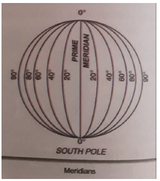
4. ……………are the imaginary lines , running from north to south.
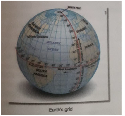
5. The network of parallels and meridians on a globe is …………….
Answers :
1) Equator
2) Earth
3) 5 ½
4) Meridians
5) Earth grid
Q3.VERY SHORT QUESTION ANSWERS :
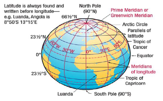
Q1.What are the lines of latitudes also called ?
Ans: Lines of latitudes are also called parallels because they run horizontally to each other and the Equator .
Q2.What are meridians ?
Ans: Meridians are the imaginary lines running vertically from North pole to South pole .They are also known as lines of Longitudes.
Q3.How many standard time zones is the world divided into ?
Ans: The world is divided into 24 standard time zone of an hour each.Each zone covers 15 of longitude .
Q4. Why a globe is important ?
Ans: A globe is useful when we want to study the earth as a whole we can see the water bodies, the axis ,the tilt and the location of the countries on the globe.
Q5. What does the term Grid means in geography ?
Ans: The network of the parallels of latitude and meridians of Longitude on the globe is known as
Q4.SHORT QUESTION ANSWERS :
Q1.What is the difference between the local time and standard time Of a place?
Ans: Local time – local time is the real time of a place according to its Corresponding longitudes. Every place has its unique Local time. Places having the same meridians of long- itude have the same local time.
Standard time – Standard time of a place is the time of that time Zone in which that place lies.In countries with large east west extant variations in local time are present,to overcome this problem standard time of specific time zone is taken as standard of that place.
Q2.What are the features of the parallels ?
Ans: The parallels are drawn at an interval of one degree. The parallels have following features.
- The equator is the longest latitude( O)and each circle becomes smaller towards the poles.
- The distance between each two latitudes is 111km.
- All parallels are located at an equal distance from each other.
Q6.LONG QUESTION ANSWER:
Q1.Write in brief the latitudes and Heat Zones of the earth , with neat diagram ?
Ans: The latitudes divide the earth into various heat zones.The different Zones have different types of climate.The three distinct heat zones
On the earth are: The Torrid Zone
The Temperate Zone
The Frigid zone
1.TORRID ZONE : This zone lies roughly between the tropic of cancer and tropic of Capricorn.This zone is the hottest zone of the earth, it receives direct rays of the sun through out the year.It is also known as the Tropical zone.
2.TEMPERATE ZONE : This zone lies between tropic of cancer and the Artic circle in the north, and the tropic of Capricorn and the Antarctic circle in the south.The sun never shines on these areas vertically,the rays of the sun are always slanted.
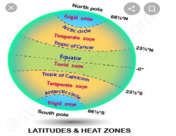
3.FRIGID ZONE : This zone is beyond the Arctic Circle in the North and the Antarctic Circle in the South,the sun never rises much above the horizon.They are the coldest regions of the earth, they get least amount of heat.
More Question..
Q1. Define the following
Globe, equator, axis, parallel of latitudes, meridian of longitudes, standard time, Indian standard time.
Q2.How are the lines of longitudes and latitudes useful?
Q3.Name 5 important parallels of latitudes?
Q4.What is the longitudinal degree of Greenwich?
Q5.What is the standard meridian of India?
Q6.Describe heat zones of the earth with the help of diagram?
Q7.Which hemisphere is ahead of Greenwich?
Q8.what is the difference between Greenwich and Indian standard time?
Q9.Fill in the blanks:-
A) Line which divides earth in two equal parts is called__________.
B) Part of earth which is toward north of equator______.
C) Part of earth which is towards south of equator_______.
D) Network of parallels and meridians is called_______.
E) Meridian which passes through greenwhich_______.
F) Sun takes_____minutes to cross one degree of longItude.
G) The change of season is due to_________.:
Q10. Why is the standard time of Bangladesh half hour ahead of India?
Globe- The model of the Earth
Answer the following questions in brief:
Q.1. Why Globe is called as model of the Earth?
Ans. Because Globe shows accurate sizes and shapes of all the physical features of the earth, such as oceans and continents.
Q.2. What is the name of the ending of screw of Globe?
Ans. The upper screw is called North Pole and lower one is called South Pole.
Q.3. What is the name given to the Semi-circles that connect both the poles?
Ans. Longitudes.
Q.4. What is Hemisphere, name the line that cuts the Globe or Earth into the Hemispheres?
Ans. Equator is the imaginary line that divides the Earth in two equal halves. Each half is known as hemisphere.
Q.5. What is the Prime Meridian, from where it passes?
Ans. Counting of meridians begin from Prime Meridian. Its value is 00 Longitude. It passes through Greenwich in England.\
Q.6. What is the difference between Longitudes and Latitudes?
Ans.
Longitudes Latitudes
1. Longitudes are also known as Meridians. 1. Latitudes are also known as Parallels.
2. These run from North to South. 2. These run from East to West.
3. These denote distance from the Prime Meridian. 3. These denote distance from the Equator.
4. These are 360 in number. 4. These are 181 in number (180+1 including Equator).
Q.7. Why Longitudes are called Meridians of Longitude. In how many Meridians we divide the Earth or Globe?
Ans. Meridians are great circles which are not parallel. Longitudes are also not parallel. That’s why Longitudes are called Meridians of Longitude.
Q.8. Which is the largest circle of Globe, name it?
Ans. The circle of Equator.
Q.9. What is the importance of Longitude?
Ans. 1. With the help of Longitudes, we are able to know the East- West distance of a place.
2. We can calculate the local time of a place.
Q.10. Which lines help us to divide earth into Heat zones? Give reasons why there are Heat Zones?
Ans. Latitudes divide earth into Heat zones.
Earth is spherical in shape. The central part of the earth receives maximum heat of the Sun and as we go towards the poles, the heat reduces. That’s why there are heat zones.
Q.11.What is the difference between Local time and Indian Standard Time?
Ans. Local time differs from place to place. So, each country adopts local time of a particular place as the Standard time for the whole country.
The Indian Standard Time is 5 hours and 30 minutes ahead of the Greenwich Time.
Fill in the Blanks:
1. Tropic of Cancer is depicted by 23½0 N parallels of Latitude.
2. Tropic of Capricorn is depicted by 23½0 S parallels of Latitude.
3. Latitudes and Longitudes make a grid on a Globe.
4. The distance between any two parallels is always equal.
5. The Prime Meridian is also known Zero Meridian.
6. In India, the Longitude of 82½0 E is considered the Standard Meridian.
7. The time difference between Greenwich Mean Time and Indian Standard Time is 5 hours and 30 minutes.
Say whether the following statements are True or False:
1. Each parallel of Latitude is a semi-circle. False
2. Temperature increases as we go away from the equator. False
3. The Torrid Zone lies between the Tropic of Cancer and Tropic of Capricorn. True
4. The Earth rotates from the West to East direction. True
Q1. Draw the diagram of a globe showing the following :-
a. Axis
b. North & south Pole
c. Tropic of cancer and Capricorn
d. Equator
e. Arctic and Antarctic circle
Q2. Draw a diagram of the globe showing the heat zones of the earth.
Fill in the blanks:
1. ______________________ is an imaginary line that divides the earth into two equal parts.
2. Latitudes and longitudes are measured in _____________________.
3. When we move away from equator the size of the parallels of latitudes ____________.
4. _________________ is the hottest zone in the earth.
5. ___________________ is the coldest zone in the earth.
6. The meridian that passes through Greenwich in England is called __________________.
7. The earth has been divided into _________________ time zones.
8. Those places east of Greenwich will be ________________ of Greenwich time and those in the west will be __________________ it.
9. The earth rotates from _________________ to _____________________.
10. The standard meridian of India is ______________________.
Fill in the blanks:
1. ________________ is a true model of the earth.
Answer : Globe
2. The earth rotates from ____________ to ______________.
Answer : West , East
3. The earth has been divided into _______ time zones.
Answer : 24
4. _________________ is the coldest zone of the earth.
Answer : Frigid zone
5. __________________ is an imaginary line that divides the earth into two equal parts.
Answer : Equator
6. Latitudes and longitudes are measured in ___________________.
Answer : Degrees
7. ______________________ is the hottest zone on the earth.
Answer : Torrid zone
8. The meridian which passes through the Greenwich in England is called _______________________.
Answer : Prime Meridian
9. The standard meridian of India is _____________.
Answer : 82(10/2)E
10. The total number of longitudes are ______________.
Answer : 360
11. The value of Prime meridian is ____________.
Answer : 00
12. The latitudinal value of Tropic of Cancer is _________________.
Answer : 23(10/2)E
13. ____________________ is time calculated by the noon sun.
Answer : Local Time
14. The Arctic circle is located in the _________________ hemisphere.
Answer : Northern
Free study material for Social Science
CBSE Social Science Class 6 The Earth our Habitat Chapter 2 Globe Latitudes and Longitudes Worksheet
Students can use the practice questions and answers provided above for The Earth our Habitat Chapter 2 Globe Latitudes and Longitudes to prepare for their upcoming school tests. This resource is designed by expert teachers as per the latest 2026 syllabus released by CBSE for Class 6. We suggest that Class 6 students solve these questions daily for a strong foundation in Social Science.
The Earth our Habitat Chapter 2 Globe Latitudes and Longitudes Solutions & NCERT Alignment
Our expert teachers have referred to the latest NCERT book for Class 6 Social Science to create these exercises. After solving the questions you should compare your answers with our detailed solutions as they have been designed by expert teachers. You will understand the correct way to write answers for the CBSE exams. You can also see above MCQ questions for Social Science to cover every important topic in the chapter.
Class 6 Exam Preparation Strategy
Regular practice of this Class 6 Social Science study material helps you to be familiar with the most regularly asked exam topics. If you find any topic in The Earth our Habitat Chapter 2 Globe Latitudes and Longitudes difficult then you can refer to our NCERT solutions for Class 6 Social Science. All revision sheets and printable assignments on studiestoday.com are free and updated to help students get better scores in their school examinations.
FAQs
You can download the latest chapter-wise printable worksheets for Class 6 Social Science The Earth our Habitat Chapter 2 Globe Latitudes and Longitudes for free from StudiesToday.com. These have been made as per the latest CBSE curriculum for this academic year.
Yes, Class 6 Social Science worksheets for The Earth our Habitat Chapter 2 Globe Latitudes and Longitudes focus on activity-based learning and also competency-style questions. This helps students to apply theoretical knowledge to practical scenarios.
Yes, we have provided solved worksheets for Class 6 Social Science The Earth our Habitat Chapter 2 Globe Latitudes and Longitudes to help students verify their answers instantly.
Yes, our Class 6 Social Science test sheets are mobile-friendly PDFs and can be printed by teachers for classroom.
For The Earth our Habitat Chapter 2 Globe Latitudes and Longitudes, regular practice with our worksheets will improve question-handling speed and help students understand all technical terms and diagrams.