

Download ICSE Class 8 Geography Solutions by Voyage
Review the Voyage Solutions for ICSE Class 8 Geography Chapter 9 India Location Extent Political And Physical Features designed for Class 8 Geography students. Published under the latest ICSE guidelines for 2026-27, these chapter-wise solutions provide the foundational knowledge required for exam success.
Access Chapter 09 India Location Extent Political And Physical Features Solutions for Class 8 Geography
Navigate directly to the Chapter 09 India Location Extent Political And Physical Features solutions using the digital viewer below. Organizing your study sessions chapter-by-chapter allows for seamless offline study and quick reference during revision.
A. Fill in the blanks
Question 1. There are ________ union territories in India.
Answer: seven
In simple words: India has seven special regions called union territories that are managed directly by the central government.
Exam Tip: Remember that some textbooks list seven union territories based on older political maps, so stick to the count given in your syllabus.
Question 2. The ________ divides India into two halves.
Answer: Tropic of Cancer
In simple words: An imaginary line called the Tropic of Cancer runs through the middle of India, splitting it into two parts.
Exam Tip: Labeling the Tropic of Cancer correctly on a blank map is a very common exam question.
Question 3. The Himalayas literally means ________.
Answer: abode of snow
In simple words: The word "Himalaya" translates directly to "home of snow" because the mountains are always covered in ice.
Exam Tip: Knowing the literal meaning of geographical names helps you write more descriptive answers in long-form questions.
Question 4. The Lakshadweep Islands have been formed by the growth of ________.
Answer: corals
In simple words: The Lakshadweep islands were built up over time by tiny sea creatures called corals.
Exam Tip: Do not confuse Lakshadweep (coral origin) with the Andaman and Nicobar Islands (volcanic origin).
B. Identify who I am
Question 1. A river that divides the Peninsular Plateau of India into the Malwa and the Deccan plateaux:
Answer: Narmada
In simple words: The Narmada river acts as a boundary line separating the northern Malwa plateau from the southern Deccan plateau.
Exam Tip: Remember that the Narmada is a west-flowing river that flows through a rift valley.
Question 2. A vast sandy low-lying plain in north-west Rajasthan:
Answer: The Thar Desert
In simple words: The Thar Desert is the large, sandy, and dry area in northwestern Rajasthan.
Exam Tip: Be sure to write "The Thar Desert" as the full name rather than just "Desert".
Question 3. Barren Island is the only volcanically active island of India.
Answer: Barren Island
In simple words: India's only active volcano is located on Barren Island.
Exam Tip: This island is located in the Andaman Sea and is an important location for map identification.
Question 4. The longest river of south India:
Answer: Godavari
In simple words: The Godavari is the largest and longest river in the southern half of India.
Exam Tip: This river is also referred to as "Dakshin Ganga" because of its great size.
C. Distinguish between each of the following pairs
Question 1. The Eastern and the Western Ghats
Answer: The differences between the Western and Eastern Ghats are described below:
| Western Ghats | Eastern Ghats |
|---|---|
| They stretch all the way from the Tapi river mouth down to Kanniyakumari. | They run from the Mahanadi Valley to the Nilgiri Hills. |
| Their average height is 1,200 m, but some peaks reach 2,440 m. | Their average height is 450 m, rarely going over 1,200 m. |
| These hills are continuous and unbroken. | They are broken up and not continuous. |
| They are the starting point for rivers flowing across the Deccan. | Numerous rivers flow through their gaps. |
| They are steep and rise sharply from the narrow west coastal plains. | They have soft slopes rising from the east coastal plains. |
| They are located close to the Arabian Sea. | They sit further back from the Bay of Bengal. |
In simple words: The Western Ghats are tall, steep, and unbroken mountains near the west coast, while the Eastern Ghats are lower, sloping, and broken hills further away from the east coast.
Exam Tip: Highlighting the differences in continuity, average height, and nearby seas in a table helps secure full marks.
Question 2. The Eastern and the Western Coastal Plains
Answer: The differences between the Western and Eastern Coastal Plains are described below:
| Western Coastal Plains | Eastern Coastal Plains |
|---|---|
| They stretch from Kachchh in the north down to the southern tip of Kanniyakumari. | They extend from the Ganga river mouth in the north to Kanniyakumari in the south. |
| These plains lie between the Western Ghats and the Arabian Sea. | These plains lie between the Eastern Ghats and the Bay of Bengal. |
| They are quite narrow. | They are comparatively wider. |
| There are no river deltas here, only estuaries and lagoons. | They feature large deltas built by major peninsular rivers. |
| Different parts are named the Konkan, Kanara, and Malabar coasts. | They are split into the Northern Circars and the Coromandel Coast. |
| They cover parts of Gujarat, Maharashtra, Goa, Karnataka, and Kerala. | They cover parts of Odisha, Andhra Pradesh, and Tamil Nadu. |
| Some of the main ports are Kandla, Mumbai, Marmagao, Mangalore, and Kochi. | Important ports on this side are Vishakhapatnam, Paradwip, Chennai, and Tuticorin. |
In simple words: The western plains are narrow strip lands near the Arabian Sea with lagoons, whereas the eastern plains are wide, delta-rich areas near the Bay of Bengal.
Exam Tip: Remember to list at least three key states and the coastal division names (like Malabar or Coromandel) for each side.
Question 3. The Himalayan and peninsular rivers
Answer: The differences between Himalayan and Peninsular rivers are described below:
| Himalayan Rivers | Peninsular Rivers |
|---|---|
| These are often called North Indian Rivers. | These are often called South Indian Rivers. |
| The primary examples are the Ganga, Indus, and Brahmaputra. | Key examples include the Mahanadi, Godavari, Krishna, Kaveri, Narmada, and Tapi. |
| They tend to be longer and move at a slower pace. | They are generally shorter and flow much faster. |
| They are fed by melting snow, making them flow all year (perennial). | They rely on monsoon rains, so they do not always flow year-round. |
| These watercourses can be easily used for boat travel (navigable). | These watercourses are not suitable for boat navigation. |
| They are highly beneficial for watering farm fields (irrigation). | They are less effective for watering agricultural lands. |
In simple words: Himalayan rivers flow all year because they get water from melting snow, while Southern rivers depend on rainfall and can dry up in hot seasons.
Exam Tip: Be sure to use the word "perennial" for Himalayan rivers and "seasonal" or "rain-fed" for Peninsular rivers to score high marks.
Question 4. The east and the west-flowing rivers of south India.
Answer: The differences between the east-flowing and west-flowing rivers of South India are described below:
| East-Flowing Rivers of South India | West-Flowing Rivers of South India |
|---|---|
| The primary streams include the Mahanadi, Godavari, Krishna, and Kaveri. | The primary streams are the Narmada and the Tapi. |
| These rivers flow into the Bay of Bengal. | These rivers flow into the Arabian Sea. |
| They form large deltas at their mouths. | They do not create deltas. |
| They carry a massive quantity of water. | They contain a smaller amount of water. |
| They begin in the Western Ghats and move toward the east. | They begin in Central India and move toward the west. |
In simple words: East-flowing rivers start in the mountains and build large deltas as they enter the Bay of Bengal, while west-flowing rivers are shorter and flow into the Arabian Sea without making deltas.
Exam Tip: Remember that Narmada and Tapi are the key exceptions that flow westward through rift valleys.
D. Answer the following questions in brief
Question 1. Do you think it is right to use the term ‘subcontinent’ for India and its neighbouring countries ?
Answer: Yes, calling India and its nearby nations a subcontinent is correct. Even though they are located in Asia, this region has its own unique physical layout and cultural traits. The tall Himalayan mountain range serves as a natural shield, keeping these countries separated from the rest of the Asian continent.
In simple words: The Himalayas act like a huge natural wall that keeps India and its neighbours separate from the rest of Asia, giving them a unique identity.
Exam Tip: Be sure to mention the role of the Himalayas in physically separating this region from the rest of Asia.
Question 2. How many states and union territories does India have ?
Answer: India is made up of 29 states along with 7 union territories.
In simple words: The political divisions of India consist of 29 states and 7 union territories.
Exam Tip: Stick to the textbook count of 29 states and 7 union territories unless instructed otherwise by your teacher.
Question 3. What do you know about the Purvanchal ranges ?
Answer: The hills located in northeastern India are known as the Purvanchal ranges. These hills run along the country's eastern border. On average, their height is below 3,000 meters. This group includes different hill chains like the Patkai Bum, Naga, Mizo, Garo, Khasi, and Jaintia Hills.
In simple words: The Purvanchal ranges are the group of low hills located in the northeastern part of India near the border.
Exam Tip: Naming specific hills like Garo, Khasi, and Jaintia will help you score full marks.
Question 4. Name the three divisions of the Great Northern Plains and the rivers responsible for their formation.
Answer: The three main parts of the Great Northern Plains are:
1. The Ganga Plains (Central region): These are created by soil left behind by the Ganga river and its branches, including the Yamuna, Gomti, Ghaghara, Gandak, Chambal, Betwa, and Son. This area covers Uttar Pradesh, Bihar, and West Bengal.
2. The Punjab Plains (Western region): These are built from soil brought by the branches of the Indus river, which are the Satluj, Beas, Ravi, Chenab, and Jhelum. This area is in Punjab and Haryana.
3. The Brahmaputra Valley (Eastern region): This is created by the Brahmaputra River and is located in Assam.
In simple words: The Northern Plains are split into the Punjab Plains in the west, the Ganga Plains in the middle, and the Brahmaputra Valley in the east.
Exam Tip: For each division, clearly mention the primary river system and the states they cover.
E. Answer the following questions in one or two paragraph:
Question 1. Explain how India has benefited from its location.
Answer: India's location has been very helpful for trade and business. Having oceans on three sides makes it easy to trade with other countries by sea. Since ancient times, India has maintained strong political, financial, and cultural ties across the globe. Today, it acts as an important bridge between the eastern and western parts of the world. This central position has greatly boosted India's own business growth.
In simple words: India's location with seas on three sides has made it easy to trade and connect with both eastern and western countries.
Exam Tip: Highlight the terms "three sides surrounded by sea" and "bridge between East and West" to write a strong answer.
Question 2. Explain how the Himalayas have greatly influenced the life of the people of India.
Answer: The Himalayas affect the lives of Indian people in many important ways:
* They act as a natural border separating India from China.
* They block the freezing winds coming from Central Asia and keep the rain-carrying monsoon winds from leaving India.
* They are the starting point for major all-year-round rivers like the Ganga, Indus, and Brahmaputra.
* Their steep, uneven land is excellent for producing electricity from water (hydroelectric power).
* The mountain sides are covered with thick forests that give us wood and other useful materials.
* They contain popular and beautiful mountain towns like Shimla, Darjeeling, and Mussoorie.
In simple words: The Himalayas act as a shield against cold winds and keep the rain in India. They also give us rivers, wood, and beautiful hill stations.
Exam Tip: Presenting these points as a bulleted list makes them easy to read and helps you gain maximum marks.
Question 3. Explain why the Great Northern Plains are densely populated.
Answer: Many people live in the Great Northern Plains for these main reasons:
1. The highly fertile soil in this region is excellent for growing a variety of crops.
2. The soft ground makes it simple to dig canals and water the fields.
3. The flat land makes it easy to build a large network of roads and railway lines.
4. The numerous rivers and streams provide an inexpensive way to travel and carry goods.
In simple words: The plains are crowded because the soil is great for farming, and the flat land makes it easy to build roads and travel.
Exam Tip: Focus on key terms like "fertile soil", "irrigation", and "flat terrain for transport" in your answer.
Question 4. Describe the Andaman and Nicobar Islands, and the Lakshadweep Islands.
Answer: India has two main groups of islands:
1. The Andaman and Nicobar Islands: Located in the Bay of Bengal, this group contains around 550 islands formed by volcanoes. Barren Island is the only active volcano here. A wide stretch of water called the Ten Degree Channel separates these islands.
2. The Lakshadweep Islands: Located in the Arabian Sea, these islands were built by coral polyps. There are fewer islands here, and many do not have any people living on them. This group is India's smallest union territory.
In simple words: Andaman and Nicobar is a large volcanic island group in the east, while Lakshadweep is a smaller coral island group in the west.
Exam Tip: Be sure to mention that the Andaman islands are of volcanic origin while the Lakshadweep islands are made of coral.
F. Picture study
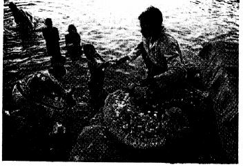
Question 1. Which are the states through which this river flows?
Answer: The Ganga river, spanning approximately 2,510 km, flows across four Indian states: Uttarakhand, Uttar Pradesh, Bihar, and West Bengal.
In simple words: The Ganga is 2,510 km long and passes through Uttarakhand, Uttar Pradesh, Bihar, and West Bengal.
Exam Tip: Always name all four states in order from west to east to show a complete understanding.
Question 2. Name any two left-bank tributaries of the river.
Answer: The tributaries on the left bank come from Himalayan glaciers. Some of the main ones include the Ramganga, Gomti, Ghaghara, Gandak, and Kosi.
In simple words: Left-bank branches of the Ganga include rivers like the Gomti and the Kosi, which start in the Himalayas.
Exam Tip: Remembering any two (like Gomti and Kosi) is enough to answer this question.
G. Map work
Question. Mark and label each of the following in an outline map of India
1. The Tropic of Cancer
2. The neighbouring countries of India
3. The Palk Strait
4. The Arabian Sea and the Bay of Bengal
Answer: To locate these features on the map of India:
1. The Tropic of Cancer is the horizontal dashed line passing through the middle of India.
2. Neighbouring countries include Pakistan, Afghanistan, China, Nepal, Bhutan, Bangladesh, and Myanmar.
3. The Palk Strait is the narrow strip of water separating the southern tip of India from Sri Lanka.
4. The Arabian Sea is located on the west coast, and the Bay of Bengal is on the east coast.
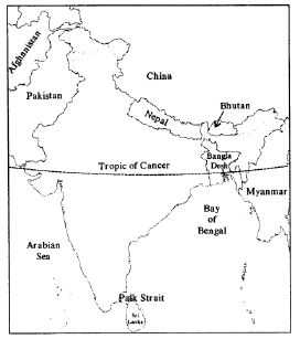
In simple words: Look at the map of India and find the middle line for the Tropic of Cancer, the nearby countries, and the seas on both sides.
Exam Tip: Practice drawing the Tropic of Cancer passing through the center of India, ensuring it touches states like Gujarat and West Bengal.
Extra Questions
Question 1. Describe the location of India.
Answer: India is located completely in the northern and eastern hemispheres. Its land extends between 8°4'N and 37°6'N latitudes, and 68°7'E and 97°25'E longitudes. The Tropic of Cancer runs through the middle, splitting the country into two. India covers an area of about 3.3 million square kilometers. The Himalayas separate India from the rest of Asia. To the south of the Tropic of Cancer is peninsular India, which is a triangular landmass stretching into the Indian Ocean, surrounded by the Arabian Sea to the west, the Bay of Bengal to the east, and the Indian Ocean to the south.
India at a Glance:
* Latitudinal stretch: 8°4' N - 37°6' N
* Longitudinal stretch: 68°7' E - 97°25' E
* Total Area: 3,287,263 sq. km
* Length from North to South: 3,214 km
* Width from East to West: 2,933 km
* Land border length: 15,200 km
* Coastline length: 7,500 km
* Number of states: 29
* Number of union territories: 7
* Capital city: New Delhi
* Total Population (2011 Census): 1.21 billion
* Average population density: 382 people per sq. km
In simple words: India is a large country in the northern and eastern hemispheres, surrounded by oceans on three sides and mountains in the north.
Exam Tip: Memorizing key numbers like the north-south length (3,214 km) and the total area is very helpful for objective-type questions.
Question 2. Name the countries that form India subcontinent.
Answer: The nations making up the Indian subcontinent are India, Pakistan, Nepal, Bhutan, Bangladesh, and Sri Lanka.
In simple words: The subcontinent is formed by India and its close neighbours like Pakistan, Nepal, Bhutan, Bangladesh, and Sri Lanka.
Exam Tip: Remember that these countries share close physical and cultural ties, which is why they are called a subcontinent.
Question 3. What is the percentage of urban and rural population in India ?
Answer: In India, about 31% of the people live in urban cities and towns, while 69% reside in rural villages.
In simple words: More than two-thirds of India's population lives in villages, while the rest lives in cities.
Exam Tip: Memorize the 31% (urban) and 69% (rural) split based on the 2011 census.
Question 4. What is taken as the standard meridian for India and why?
Answer: The standard meridian of India is set at \( 82 \frac{1}{2}^\circ \text{E} \) longitude, which passes through Allahabad. This is chosen because it lies right in the middle of India's wide east-west span. Since every degree of longitude changes the local time by 4 minutes, there is a two-hour difference between Gujarat in the far west and Arunachal Pradesh in the far east. Having a standard meridian ensures that the entire country follows the exact same time, preventing any confusion.
In simple words: The line of longitude in the middle of India is used to set one standard time for the whole country, so everyone has the same time on their clocks.
Exam Tip: Be sure to explain how the 4-minute time gap per degree of longitude leads to a 2-hour difference between the east and west.
Question 5. Name the neighbouring countries of India.
Answer: India's neighbours include Pakistan, Afghanistan, China, Nepal, Myanmar, Bangladesh, Bhutan, along with the island nations of Sri Lanka and the Maldives.
In simple words: India shares borders and seas with countries like Pakistan, China, Nepal, Bangladesh, Sri Lanka, and the Maldives.
Exam Tip: Grouping them into land neighbours and sea neighbours (like Sri Lanka and Maldives) is a great way to present this answer.
Question 6. What separates India from Sri Lanka ?
Answer: The narrow water passage of the Palk Strait and the Gulf of Mannar lie between India and Sri Lanka, keeping them separate.
In simple words: India and Sri Lanka are separated by two water bodies called the Palk Strait and the Gulf of Mannar.
Exam Tip: Make sure to name both the Palk Strait and the Gulf of Mannar for full points.
Question 7. Name the three water bodies which surround the India Peninsular.
Answer: The three seas surrounding the Indian peninsula are:
1. The Arabian Sea to the west
2. The Bay of Bengal to the east
3. The Indian Ocean to the south
In simple words: India is surrounded by the Arabian Sea on the left, the Bay of Bengal on the right, and the Indian Ocean at the bottom.
Exam Tip: Remembering "West - Arabian, East - Bengal, South - Indian" is a quick way to keep these straight.
Question 8. On what basis were the states of India reorganised after independence ? Name the states and union territories of India along with their capitals. (Political divisions).
Answer: Following independence, India's states were reshaped primarily based on the languages spoken by the people. Currently, the country is divided into 29 states and 7 union territories.
States & Capitals Table:
| S.No. | State | Capital |
|---|---|---|
| 1 | Andhra Pradesh | Hyderabad |
| 2 | Arunachal Pradesh | Itanagar |
| 3 | Assam | Dispur |
| 4 | Bihar | Patna |
| 5 | Chhattisgarh | Raipur |
| 6 | Goa | Panaji |
| 7 | Gujarat | Gandhinagar |
| 8 | Haryana | Chandigarh |
| 9 | Himachal Pradesh | Shimla |
| 10 | Jammu and Kashmir | Srinagar |
| 11 | Jharkhand | Ranchi |
| 12 | Karnataka | Bengaluru |
| 13 | Kerala | Thiruvananthapuram |
| 14 | Madhya Pradesh | Bhopal |
| 15 | Maharashtra | Mumbai |
| 16 | Manipur | Imphal |
| 17 | Meghalaya | Shillong |
| 18 | Mizoram | Aizawl |
| 19 | Nagaland | Kohima |
| 20 | Odisha | Bhubaneshwar |
| 21 | Punjab | Chandigarh |
| 22 | Rajasthan | Jaipur |
| 23 | Sikkim | Gangtok |
| 24 | Tamil Nadu | Chennai |
| 25 | Tripura | Agartala |
| 26 | Uttar Pradesh | Lucknow |
| 27 | Uttarakhand | Dehra Dun |
| 28 | West Bengal | Kolkata |
| 29 | Telangana | Hyderabad |
Union Territories Table:
| S.No. | Union Territory | Capital |
|---|---|---|
| 1 | Andaman and Nicobar Islands | Port Blair |
| 2 | Chandigarh | Chandigarh |
| 3 | Dadra and Nagar Haveli | Silvassa |
| 4 | Daman and Diu | Daman |
| 5 | Lakshadweep | Kavaratti |
| 6 | Delhi | Delhi |
| 7 | Puducherry | Puducherry |
| 8 | India | New Delhi |
In simple words: States in India were divided up based on the main languages spoken in each area.
Exam Tip: Learning the capitals of the northeastern states (like Gangtok, Dispur, and Shillong) is very useful as they are frequently tested.
Question 9. Name the point in the Himalayas where the boundaries of five countries meet. Name the countries.
Answer: The Indira Col in the Himalayan range is the spot where the borders of five nations meet. These nations are India, Pakistan, Afghanistan, China, and Tajikistan.
In simple words: Indira Col is the high point in the mountains where India, Pakistan, China, Afghanistan, and Tajikistan all meet.
Exam Tip: Clearly spell "Indira Col" as the exact location where these five borders converge.
Question 10. Name the six main physical divisions of India.
Answer: The six primary geographical zones of India are:
1. The Northern Mountains
2. The Great Northern Plains
3. The Peninsular Plateau
4. The Coastal Plains
5. The Thar Desert
6. The Islands
In simple words: India's land is divided into six types, like mountains, flat plains, dry deserts, plateaus, coasts, and islands.
Exam Tip: Listing all six physical divisions in sequence from north to south is the standard way to answer.
Question 11. What do the Northern Mountains consist of ?
Answer: The Northern Mountains are made up of the tall Himalayan range and the hills in northeastern India. Together, they create the northern and northeastern borders of the nation.
In simple words: The Northern Mountains include the Himalayas and the northeast hills, forming a natural wall at India's top border.
Exam Tip: Mention both the Himalayas and the northeastern hills to give a complete answer.
Question 12. The Himalayas are rising even now. Comment.
Answer: The Himalayas are quite young mountains that grew from soil deposits in the old Tethys Sea. Around 185 million years ago, this sea sat between two giant landmasses: Laurasia to the north and Gondwanaland to the south. Deep movements inside the Earth forced these landmasses together until they crashed. This massive collision pushed the seabed upward in folds, creating the mountains. Because these forces are still active, the Himalayas continue to rise today.
In simple words: Long ago, two huge landmasses crashed into each other, pushing up the seabed to form the Himalayas. They are still being pushed up slowly today.
Exam Tip: Use key words like "Tethys Sea", "collision", and "folding upwards" to describe the formation process.
Question 13. Name the three main ranges of the Himalayas. Compare them.
Answer: The Himalayas consist of three parallel mountain ranges compared in the table below:
| The Greater Himalayas (Himadri) | The Lesser Himalayas (Himachal) | The Outer Himalayas (Shiwalik) |
|---|---|---|
| They form the northernmost range of the Himalayan mountains. | They lie in the middle, between the outer and greater ranges. | They form the southern foothills of the Himalayas. |
| The maximum height reaches up to 8,850 meters (including Mt. Everest). | The maximum height reaches up to 5,000 meters. | The maximum height reaches about 1,500 meters. |
| Many peaks here stand at a height of more than 8,000 meters. | This range has a width of 75 km. Valleys like Kashmir, Kulu, and Kangra are located here. | Their width is about 15 - 50 km. They are a rich source of wood and timber. |
In simple words: The Himalayas have three parallel parts: the tall Himadri in the north, the middle Himachal with beautiful valleys, and the lower Shiwalik in the south.
Exam Tip: Clearly link the names "Himadri", "Himachal", and "Shiwalik" with their correct positions and heights.
Question 14. Name few passes or gaps in the Himalayas that serve as important passages through the northern mountain wall.
Answer: A few key mountain passes in the Himalayas that provide pathways through the tall northern range are Shipki La, Thaga La, Nathu La, and Jelep La.
In simple words: Gaps in the mountains called passes, like Nathu La, let people travel through the high Himalayas.
Exam Tip: Note that "La" means "pass" in the local mountain languages.
Question 15. What is the location and extend of the Great Northern Plains ? Which rivers have formed it ?
Answer: The Great Northern Plains are located between the Northern Mountains to the north and the Peninsular Plateau to the south. They stretch across a distance of about 2,400 km, starting from Punjab in the west to the Brahmaputra Valley in the east. This vast flat area was built by three primary rivers - the Indus, the Ganga, and the Brahmaputra - along with their branches.
In simple words: The plains lie below the mountains and are formed by soil from three main rivers: the Indus, Ganga, and Brahmaputra.
Exam Tip: Be sure to mention the three key river systems (Indus, Ganga, Brahmaputra) responsible for making these plains.
Question 16. Where do the Ganga and the Brahmaputra join and where do they drain ?
Answer: The Ganga and Brahmaputra rivers meet in Bangladesh, flowing together under the name Padma before emptying into the Bay of Bengal. Together, these two rivers have created the Sundarbans, which is the largest delta across the globe.
In simple words: The Ganga and Brahmaputra meet in Bangladesh, become the Padma river, flow into the Bay of Bengal, and create the massive Sundarbans delta.
Exam Tip: State both the name of the combined river (Padma) and the famous delta (Sundarbans) they form.
Question 17. Write a short note on the Peninsular Plateau.
Answer: The Peninsular Plateau is a very old landmass created from tough, crystalline rocks of igneous and metamorphic origin. It has a triangular shape that is wide at the top in the north and narrows down toward Kanniyakumari in the south. This plateau stretches from the Aravalli Range in the west to the Chota Nagpur Plateau in the east. The Narmada river splits this plateau into two sections:
(a) The Malwa Plateau:
1. It is bordered by the Vindhya Range in the south, the Aravalli Range in the west, and the Chota Nagpur Plateau in the east.
2. It is drained by rivers such as the Chambal, Sind, Betwa, Ken, Son, and Damodar.
(b) The Deccan Plateau:
1. It is bordered by the Satpura Range in the north, the hills of the Western Ghats in the west, and the Eastern Ghats in the east.
2. It is drained by rivers like the Mahanadi, Godavari, Krishna, and Kaveri.
In simple words: The Peninsular Plateau is a triangular, rocky land split in two by the Narmada river: the Malwa Plateau in the north and the Deccan Plateau in the south.
Exam Tip: Clearly separate the Malwa and Deccan plateaus in your description, noting how the Narmada river divides them.
Question 18. How have the rocks of the Deccan Plateau formed ?
Answer: The rocks forming the Deccan Plateau were created when lava erupted from large cracks in the Earth and cooled down. The lava spread out in wide sheets, creating one of the largest and deepest layers of volcanic lava flows in the world.
In simple words: Volcanoes long ago spilled lava through cracks in the ground. This lava cooled and hardened to form the solid rocks of the Deccan Plateau.
Exam Tip: Use terms like "cooling of lava" and "earth fissures" to explain how these rocks formed.
Question 19. Write a short note on Thar desert.
Answer: The Thar Desert is a flat, sandy region with low-lying plains and moving sand dunes. It is located mostly in northwestern Rajasthan, sitting between the Aravalli hills to the east and the Sind Desert of Pakistan to the west. This area receives very little rain - under 25 cm per year - leading to a shortage of water. The Luni river is the only small stream that flows here. However, the Indira Gandhi Canal has brought water to parts of the desert, turning some areas fertile enough to grow crops like wheat, barley, grapes, and melons.
In simple words: The Thar Desert in Rajasthan is very dry and sandy, but canals have now brought water to help grow crops like wheat and grapes.
Exam Tip: Mention the Luni River and the Indira Gandhi Canal to show how the desert's geography has changed.
Question 20. Name the two categories of rivers of India.
Answer: Based on where they start, Indian rivers are divided into two main groups:
1. The North Indian or Himalayan Rivers: These start from melting glaciers high up in the mountains.
2. The South Indian or Peninsular Rivers: These depend on rainfall to fill their channels.
In simple words: Indian rivers are either Himalayan rivers (fed by melting snow) or Peninsular rivers (fed by rain).
Exam Tip: Clearly state that Himalayan rivers are glacier-fed while Peninsular rivers are rain-fed.
Question 21. Name the five tributaries of river Indus.
Answer: The five primary tributaries of the Indus river, together called the Panchnadi, are the Satluj, Beas, Ravi, Chenab, and Jhelum.
In simple words: The five rivers that join the Indus are the Satluj, Beas, Ravi, Chenab, and Jhelum.
Exam Tip: Learn the group name "Panchnadi" which refers to these five famous rivers of Punjab.
Question 22. Name the states from where the river Indus, Ganga and Brahmaputra flow in India.
Answer: The pathways of these three major rivers in India are:
* The Indus river enters from Tibet and flows through Jammu and Kashmir before traveling into Pakistan.
* The Ganga river travels through four states: Uttarakhand, Uttar Pradesh, Bihar, and West Bengal.
* The Brahmaputra river runs through Arunachal Pradesh and Assam.
In simple words: In India, the Indus flows in Jammu and Kashmir, the Ganga runs through four northern states, and the Brahmaputra flows in the northeast.
Exam Tip: Name all the states accurately for each river to earn full marks.
Question 23. Which river is called the ‘Ganga of the South’ ?
Answer: The Godavari river is known as the 'Ganga of the South'.
In simple words: The Godavari river is called the Ganga of the South.
Exam Tip: This is a popular one-mark question; remember that the Godavari is also the longest river in South India.
Question 24. Define the following:
1. Alluvial plain
2. A Pass
3. Tributary
Answer: Definitions of the terms:
1. Alluvial plain: A flat area of land made from the fine sand and soil deposited by a flowing river.
2. Pass: A natural opening or low path through a mountain range that allows people to travel across it.
3. Tributary: A smaller stream or river that joins and empties into a larger main river.
In simple words: An alluvial plain is made of river soil, a pass is a mountain path, and a tributary is a small river joining a big one.
Exam Tip: Use simple, clear definitions and provide an example for each to secure maximum marks.
Question 25. How are rivers important to humans ?
Answer: Rivers are vital to human life for several key reasons:
1. They supply fresh water for household tasks, farming, factories, food, and jobs.
2. They provide a means for moving people and cargo by boat.
3. They are used for fun activities and have deep spiritual or religious importance.
In simple words: Rivers give us drinking water, help water our farms, and are used for travel and religious festivals.
Exam Tip: List water supply, transport, and cultural importance as three separate points.
Question 26. Fill in the blanks
(1) India is a part of the continent of ________.
(2) India is ________ largest country and has ________ largest population in the world.
(3) India lies entirely in the ________ and ________ hemispheres.
(4) The ________ longitude is the Standard Meridian for India.
(5) The ________ separate India from the rest of the Asia.
(6) ________ is the point in the Himalayas where the boundaries of five countries meet.
(7) ________ is referred to as the National Capital Territory of India.
(8) The ________ are the source of perennial rivers such as the Indus, the Ganga and the Brahmaputra rivers.
(9) The ________ extend from Punjab in the west to the Brahmaputra Valley in the east.
(10) The ________ soil of the river valleys/plains is very fertile.
(11) The largest delta in the world built by the Ganga and the Brahmaputra is ________.
(12) The Peninsular Plateau of India is ________ in shape.
(13) On either side of the Peninsular Plateau of India are the ________ of India.
(14) ________ grow profusely in the Coastal Plains of India.
(15) The Thar Desert receives less than ________ cm rain annually.
(16) ________ is the only significant river in the Thar desert but carries very little water.
(17) The Andaman and Nicobar Islands are separated by a wide channel called the ________ channel.
(18) The ________ Islands lie at a distance of 200-400 km from the Malabar Coast.
(19) The ________ Islands is the smallest union territory of India.
(20) The river Indus and river Brahmaputra originate in ________ before entering India.
(21) The river Ganga has it source in the ________ glacier.
(22) River Brahmaputra enters India in ________ from Tibet.
(23) The west flowing rivers of the Peninsular rivers drain into the ________.
(24) The margins of the Deccan Plateau consist of hills called the ________ in the east and the ________ in the west.
Answer: The completed statements are:
(1) Asia
(2) seventh, second
(3) northern, eastern
(4) \( 82 \frac{1}{2}^\circ \text{E} \)
(5) Himalayas
(6) Indira Col
(7) Delhi
(8) Himalayas
(9) Great Northern Plains
(10) alluvial
(11) Sundarbans
(12) triangular
(13) Coastal Plains
(14) Coconut Palms
(15) 25
(16) Luni
(17) Ten Degree
(18) Lakshadweep
(19) Lakshadweep
(20) Tibet
(21) Gangotri
(22) Arunachal Pradesh
(23) Arabian Sea
(24) Eastern Ghats, Western Ghats
In simple words: This section reviews all the important facts about India's size, borders, rivers, plains, and mountain ranges.
Exam Tip: Practice filling out blank maps of India with these key features to build a solid spatial understanding of the country's geography.
Map Skills
1. On a Political Map of India, show all the States and Union territories of India along with their Capitals.
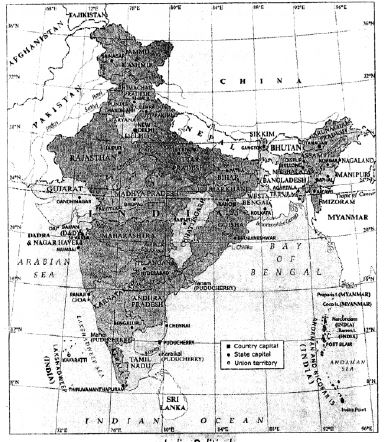
2. On an outline map of India, show the important physical features.
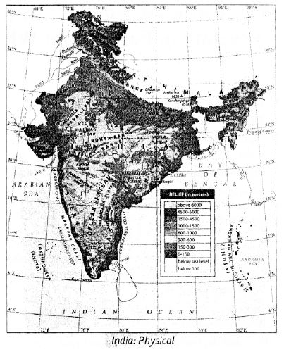
Free study material for Geography
Verified Textbook Solutions for Class 8 Geography Chapter 09 India Location Extent Political And Physical Features
Verified Problem Answers for Class 8 Geography Chapter 09 India Location Extent Political And Physical Features
Review accurate ICSE solutions for Chapter 09 India Location Extent Political And Physical Features tailored for Class 8 Geography students. Use these step-by-step notes to simplify difficult textbook exercises and improve exam readiness.
Step-by-Step Explanations and Breakdown
Every exercise question in this chapter includes step-by-step working steps, allowing you to self-evaluate, catch mistakes early, and understand the underlying logic.
More Study Resources for Class 8 Geography
Pair your solution review with additional practice papers to test your execution speed and ensure total preparedness for school exams.
FAQs
You can download the verified Voyage solutions for Chapter 09 India Location Extent Political And Physical Features on StudiesToday.com. Our teachers have prepared answers for Class 8 Geography as per 2026-27 ICSE academic session.
Yes, our solutions for Chapter 09 India Location Extent Political And Physical Features are designed as per new 2026 ICSE standards. 40% competency-based questions required for Class 8, are included to help students understand application-based logic behind every Geography answer.
Yes, every exercise in Chapter 09 India Location Extent Political And Physical Features from the Voyage textbook has been solved step-by-step. Class 8 students will learn Geography conceots before their ICSE exams.
Yes, follow structured format of these Voyage solutions for Chapter 09 India Location Extent Political And Physical Features to get full 20% internal assessment marks and use Class 8 Geography projects and viva preparation as per ICSE 2026 guidelines.