

Official Voyage Textbook Solutions for Class 8 Geography
Access the official Voyage textbook solutions for Class 8 Geography, updated for the 2026-27 academic year. This digital resource is structured to help students build strong conceptual clarity and prepare effectively for school examinations.
Read and Download Chapter 10 India Climate Natural Vegetation Forests And Wildlife Solutions
Navigate directly to the Chapter 10 India Climate Natural Vegetation Forests And Wildlife solutions using the digital viewer below. Organizing your study sessions chapter-by-chapter allows for seamless offline study and quick reference during revision.
A. Fill in the blanks
Question 1. The state that first receives the monsoon rains :
Answer: Kerala.
In simple words: Kerala is the very first state in India to get the monsoon rains.
Exam Tip: Remember that the monsoon hits the southwestern coast of India first, starting with the state of Kerala.
Question 2. A place that receives the heaviest rainfall in India and the world:
Answer: Mawsynram.
In simple words: Mawsynram gets more rain than any other place on Earth.
Exam Tip: Spell "Mawsynram" carefully, as it is a common one-mark question in exams.
Question 3. Depression that causes winter rainfall in north-west India :
Answer: Western disturbance.
In simple words: This is a type of winter storm that brings rain to northwestern parts of India.
Exam Tip: The term "Western disturbance" is crucial when explaining winter rainfall in states like Punjab.
Question 4. In mixed deciduous forests :
Answer: Sal and Oak trees are found.
In simple words: Sal and Oak are the main types of trees in these forests.
Exam Tip: Be ready to name these two key tree species as typical examples of mixed deciduous vegetation.
B. Write true or false. Correct the false statements
Question 1. Babool and kikar trees are mainly found in Rajasthan, Gujarat, and on the leeward side of the Western Ghats.
Answer: This is incorrect. These plants grow mostly in Rajasthan, Punjab, and the dry rain shadow side of the Western Ghats.
In simple words: The statement is false because these trees grow in Punjab, not Gujarat, along with Rajasthan and the dry side of the hills.
Exam Tip: If a statement is false, always write down the fully corrected sentence to secure full marks in your exam.
Question 2. Increase in height is responsible for the changing vegetation in the Himalayas.
Answer: This statement is correct.
In simple words: The types of trees change as you go higher up the mountains.
Exam Tip: Higher altitudes have cooler temperatures, which directly affects the type of forest that can grow there.
Question 3. Thorn forests occupy the largest area in India.
Answer: This is incorrect. The type of forest that covers the most land in India is the tropical monsoon deciduous forest.
In simple words: Deciduous forests cover the biggest part of India, not thorny ones.
Exam Tip: Remember that tropical deciduous forests are also called monsoon forests and are the most widespread forest type in India.
Question 4. Hogla is mainly found in the tidal forests.
Answer: This is correct.
In simple words: Hogla grass grows in swampy areas near the sea.
Exam Tip: Hogla is a major plant species of the mangrove or tidal forests, which are located in coastal delta regions.
C. Give geographical reasons for each of the following :
Question 1. South India is warmer than north India.
Answer: The southern part of India lies closer to the equator. Because of this, it stays warm. Also, the sea surrounds South India. This keeps the climate mild all year. It never gets too hot or too cold there. On the other hand, North India is very far from the equator. It has no sea nearby. This means it gets extremely hot during summer and very cold during winter.
In simple words: South India is warm and mild because it is near the equator and the ocean. North India is far from both, so it has very hot summers and very cold winters.
Exam Tip: Mention two main factors: distance from the equator (latitude) and distance from the sea (continental vs. equable climate).
Question 2. The south-west monsoon is divided into two branches.
Answer: The pointed shape of southern India splits the incoming winds. This peninsular landmass divides the wind into two paths. One path goes over the Arabian Sea. It brings rain to western areas. The other path goes over the Bay of Bengal. This part brings rain to the northeastern areas of the country.
In simple words: The V-shape of southern India splits the wet wind into two parts. One part blows over the Arabian Sea, and the other blows over the Bay of Bengal.
Exam Tip: Be sure to write the word "peninsular" and clearly name both branches: the Arabian Sea branch and the Bay of Bengal branch.
D. Answer the following questions in brief
Question 1. What type of climate does the Indian subcontinent have ?
Answer: India and its neighbors have a tropical monsoon type of climate. Throughout the year, temperatures remain quite high. The summer months are hot and full of rain. The country has very clear wet and dry times of the year.
In simple words: India has a hot climate with very clear rainy and dry seasons.
Exam Tip: Always use the term "tropical monsoon climate" to get full marks for this question.
Question 2. State two ways in which the Himalayas act as a climate barrier.
Answer: Here are two ways these mountains protect India's climate:
1. They stop the icy winds of Central Asia from blowing into the country. This keeps winters in India from getting too cold.
2. They block the wet monsoon winds from flying out of India. This makes sure the country gets plenty of rain.
In simple words: The mountains block freezing northern winds from entering, and they trap the wet summer winds so it can rain.
Exam Tip: Clearly list both functions of the barrier: stopping cold northern winds and trapping rain-bearing southern winds.
Question 3. Why does India have a tropical monsoon climate ?
Answer: The giant Himalayan mountains are the main reason for this type of climate. They block the freezing winds of Asia from reaching the northern parts of India. At the same time, they trap the wet summer winds. This forces them to shed rain across the entire land.
In simple words: The Himalayas block freezing air from entering and keep rain clouds inside the country, creating a hot, rainy climate.
Exam Tip: Focus your answer on how the Himalayas block cold winds and trap the monsoons to shape India's climate.
Question 4. Name two states of north India that receive rainfall in winter. What is the cause of winter rainfall in these states?
Answer: Punjab and Jammu and Kashmir are two northern areas that get rain in winter. This rainfall is caused by weather systems called western disturbances. These are low-pressure storms or cyclones. They start far away over the Mediterranean Sea and travel to India.
In simple words: Punjab and Kashmir get winter rain. This rain comes from special storms called western disturbances that travel all the way from the Mediterranean Sea.
Exam Tip: Be sure to spell "western disturbances" and "Mediterranean" correctly, as they are key terms for scoring full marks.
Question 5. Where would you find the following in India: Asiatic lion, Royal Bengal tiger, one-horned rhinoceros, and red panda?
Answer:
• You can only find the Asiatic lion in Gujarat's Gir forests.
• The Royal Bengal tiger lives mostly in the Himalayan foothills and forests, as well as the Sunderbans delta of the Ganga.
• The one-horned rhinoceros resides in the grassy plains of Assam and West Bengal.
• The red panda lives in the cold, snowy slopes of the Himalayas.
In simple words: These rare animals live in different parts of India, like the Gir forests, the Sunderbans delta, Assam, and the high cold mountains.
Exam Tip: Be precise with the locations, specifically matching the "Asiatic lion" to the "Gir forests" and the "one-horned rhinoceros" to "Assam".
Question 6. Mention any three national parks in India.
Answer: These protected areas help save India's wild animals and forests. Here are five famous national parks in the country:
1. Kaziranga National Park: Situated in Assam, this park protects the rare one-horned rhino.
2. Ranthambore National Park: Found in Rajasthan's Sawai Madhopur area, this park has evergreen patches and trees like mango and banyan. It is vital for protecting tigers.
3. Sundarbans National Park: This park is located in West Bengal and serves as a primary sanctuary for tigers.
4. Bandhavgarh National Park: Located in Madhya Pradesh, this reserve acts as a secure habitat for tigers.
5. Kanha National Park: Known as an exceptionally clean and well-kept park, it gave Rudyard Kipling the ideas to write his famous book, 'The Jungle Book'.
In simple words: National parks protect forests and wild animals. Some famous ones are Kaziranga in Assam, Ranthambore in Rajasthan, and Kanha in Madhya Pradesh.
Exam Tip: Be ready to match each national park with the specific state and animal it is famous for protecting.
Question 7. Mention any five biosphere reserves in India.
Answer: Here are some of the key biosphere reserves located in the country:
1. Nilgiri Biosphere Reserve: Found in southern India across the Western Ghats and Nilgiri Hills.
2. Gulf of Mannar Biosphere Reserve: Situated between India and Sri Lanka, in the Laccadive Sea.
3. Sundarbans Biosphere Reserve: Located in West Bengal.
4. Nanda Devi Biosphere: Found in the northeastern part of Uttarakhand.
5. Nokrek Biosphere Reserve: Situated in the West Garo Hills of Meghalaya.
6. Pachmarhi Biosphere Reserve: Located in Madhya Pradesh's Satpura Range.
7. Similipal Biosphere Reserve: Found in northeastern Odisha.
8. Achanakmar-Amarkantak Biosphere Reserve: Located across Madhya Pradesh and Chhattisgarh.
9. Great Nicobar Biosphere Reserve: Situated in the Nicobar Islands.
In simple words: Biosphere reserves are large areas that protect nature. Examples include the Nilgiri in the south, Nanda Devi in the north, and Sundarbans in the east.
Exam Tip: Learn at least five of these biosphere reserves along with the states where they are located for your exams.
E. Answer the following questions in one or two paragraphs
Question 1. Describe the seasons experienced in India and also state the months and their duration.
Answer: India's tropical monsoon climate is divided into three key seasons:
1. The Hot Dry Season - March to May
2. The Hot Wet Season - June to October
3. The Cool Dry Season - November to February
1. The Hot Dry Season: In March, temperatures begin to go up. By May, they can cross 48°C in desert areas. The Northern Plains stay around 35°C to 40°C. Hills and coastal areas have cooler, mild weather. This heat causes local storms and quick rains. These are known as 'loo' in Rajasthan, 'Mango showers' in Kerala, and 'Kalbaisakhi' in areas like West Bengal and Assam.
2. The Hot Wet Season (Rainy Season): By June, high temperatures build a low-pressure zone over the land. This makes wet, heavy winds blow from the ocean toward the land. We call these the southwest monsoons. They bring heavy rainfall, thunder, and lightning. This cools the air by about 3°C to 6°C. The rains first hit the state of Kerala. The southwest monsoon has two main paths:
(a) The Arabian Sea Branch: This stronger path brings heavy showers to the Western Ghats. It then crosses the Deccan Plateau and inner areas, which get very little rain - around 50 to 60 cm.
(b) The Bay of Bengal Branch: This path brings massive rainfall to northeast India. It then turns along the Himalayas to cover the Northern Plains. By the time it reaches the northwest, it is dry. Thus, those regions get very little rain.
Near the end of September, India cools down because sunlight moves toward the equator. The land becomes cool, creating high pressure. The oceans stay warmer, forming low pressure. Because of this, the winds turn around. They now blow from the land back to the ocean. These are called retreating monsoons. Tamil Nadu gets less rain in summer, but gets plenty of winter rain from the northeast monsoon.
3. Cold Dry Season: Winter runs from November to February. It is cold in the north and dry inland. Average temperatures drop below 10°C in the northwest, while plains stay around 21°C. High mountain places like Shimla and Srinagar get snow. Since South India is near the equator, it stays warm. Cold waves often hit the north. Rain is rare across the country because dry winds blow from land to sea. However, winter rains fall in the northwest and on the Coromandel Coast. This means Tamil Nadu gets winter rain from the northeast monsoons. In the northwest, western disturbances bring cyclonic rains to states like Punjab and Kashmir. This small amount of rain is crucial for winter crops like wheat and barley.
In simple words: India has three main seasons: a hot dry summer, a wet rainy monsoon, and a cool dry winter. Winter rain is very helpful for growing crops like wheat.
Exam Tip: Be sure to list all three seasons along with their exact months, and describe the two branches of the southwest monsoon clearly.
Question 2. Which winds bring rainfall to the Western Ghats ? Why is the Deccan Plateau relatively dry during the rainy season? Why do Punjab and Rajasthan get very little rainfall during the monsoons ?
Answer: The wet southwest monsoon winds from the Arabian Sea branch bring heavy rain. This falls on the windward slopes of the Western Ghats.
The Deccan Plateau is on the leeward side of these hills, so it gets very little rain. This keeps it dry during the monsoon months.
The Bay of Bengal branch brings heavy rain to northeastern India first. The giant Himalayas stop these winds from leaving the country. They force them to turn west across the Ganga Plains. As they move northwest, they lose their moisture and become dry. Because of this, Rajasthan and Punjab receive very little rain. Punjab is also the last state to get the monsoon rains.
In simple words: The Western Ghats block the Arabian Sea winds, leaving the Deccan Plateau dry on the other side. The Bay of Bengal winds lose all their moisture as they travel west, so Punjab and Rajasthan get very little rain.
Exam Tip: Use terms like "windward side" for the Western Ghats and "leeward side" or "rain-shadow area" for the Deccan Plateau to score full marks.
Question 3. Explain the importance of monsoon.
Answer: The monsoons are highly vital for India. Here are the main reasons why:
1. Economic Growth: A strong monsoon brings wealth. It boosts the nation's economy. This is because farming makes up about 16 percent of India's Gross Domestic Product (GDP).
2. Crop Growth: Hot temperatures and heavy rains in summer are needed for kharif crops. In winter, light rain and watering help grow rabi crops.
3. Stable Food Prices: Regular rain helps grow enough food. This keeps food prices low. If the monsoon fails, food costs rise quickly, which can trouble the whole country.
4. Water Sources: Many rivers, canals, dams, and reservoirs get their water from monsoon rains.
5. Other Industries: Important jobs like fishing and forestry also depend directly on how much rain falls.
6. Relief from Heat: The rain brings relief from the extreme summer heat and refreshes the land.
7. Cultural Unity: Monsoons bring the people of India together. Farmers wait eagerly for the rains to start their crops. Many festivals are celebrated to mark a good harvest. These include Bihu in Assam, Pongal in Tamil Nadu, Onam in Kerala, and Lohri in Punjab. Good rain brings joy to everyone, while no rain brings hunger and sadness.
In simple words: Monsoons are crucial because they water crops, keep food prices low, fill rivers, and bring people together to celebrate harvest festivals.
Exam Tip: Mention both the economic benefits (like agriculture and GDP) and cultural significance (festivals like Pongal and Onam) when writing about the monsoon's importance.
Question 4. List the different types of vegetation found in India. Describe any two.
Answer: India has several kinds of natural plants and trees. They are grouped into:
Based on rainfall:
• Tropical evergreen forests
• Tropical deciduous forests
• Thorn and desert forests
Based on land height (relief):
• Tidal or mangrove forests
• Mountain or Alpine forests
Here is a description of two of these forest types:
1. Tropical evergreen rain forests: These forests grow in wet regions with over 300 cm of yearly rain. The climate stays humid with temperatures around 25°C to 27°C. You can find them in places like Karnataka, Kerala, the hills of northeast India, and the Andaman and Nicobar Islands. The trees have broad leaves and hardwood. They grow very tall, up to 60 meters, and create thick layers. This makes logging and timber trade difficult. Common trees here include bamboo, ebony, mahogany, and rosewood.
2. Monsoon deciduous forests: These forests grow where yearly rain is between 100 and 200 cm. They have clear dry and wet seasons. You can find them across the Deccan Plateau, the Western Ghats, and up to the northern Shivalik hills. Trees shed their leaves in the dry season to save water. They are spaced out, have long roots, and are not very tall. Important trees here include teak, sal, sandalwood, and banyan.
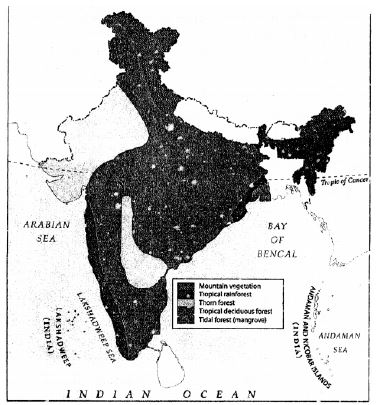
In simple words: India has different forests depending on rain and hills. Evergreen forests stay green all year with lots of rain, while deciduous forests shed their leaves in the dry season.
Exam Tip: Memorize the rainfall and temperature requirements for both evergreen (over 300 cm rain, 25-27°C) and deciduous (100-200 cm rain) forests to secure full marks.
Question 5. How are the tropical evergreen forests different from the tropical deciduous forests ?
Answer:
| Tropical Evergreen Forests | Tropical Deciduous Forests |
|---|---|
| (i) Located in regions receiving more than 300 cm of annual rain. | (i) Located in regions receiving between 100 and 200 cm of annual rain. |
| (ii) Do not experience distinct seasons and stay humid throughout the year. | (ii) Have clear and distinct wet and dry seasons. |
| (iii) Temperatures typically range from 25°C to 27°C or higher. | (iii) Experience a lower range of temperatures. |
| (iv) Trees can grow very tall, reaching heights of up to 60 meters. | (iv) Trees are comparatively shorter. |
| (v) Very dense and thick forest cover. | (v) Open and less dense, with trees spaced further apart. |
| (vi) Remain green all year and do not shed all their leaves at once. | (vi) Trees shed their leaves during the dry period to save water. |
| (vii) Very hard to use for timber as they are thick and hard to enter. | (vii) Highly valued for commercial use and timber. |
| (viii) Common trees include shisham, ebony, rosewood, telsar, cedar, mahogany, and bamboo. | (viii) Common trees include teak, sal, mahua, khair, sandalwood, jackfruit, semal, and banyan. |
| (ix) Found in Kerala, Maharashtra, Karnataka, northeastern hills, and the Andaman and Nicobar Islands. | (ix) Found from the Western Ghats to the Shivalik range, northeastern areas, and the Deccan Plateau. |
In simple words: Evergreen forests stay green all year and are too thick to easily cut down for wood. Deciduous forests lose their leaves in dry months and are very useful for getting commercial timber.
Exam Tip: Highlighting differences in rainfall (over 300 cm vs 100-200 cm) and tree shedding habits (no shedding vs dry season shedding) is the best way to earn full points in comparison questions.
Question 7. Give an account of the biosphere reserves in India.
Answer: Biosphere reserves across India are expansive natural sanctuaries that frequently encompass one or more national parks or sanctuaries where limited economic operations are permitted. Rather than safeguarding just the local plants and animals, these zones also protect native populations and their traditional lifestyles. Each reserve is split into three distinct sectors designed to aid wildlife preservation. The Core zone is a strictly protected territory where both land and aquatic systems remain completely untouched by human interference. Its primary objective is preserving biological diversity and facilitating non-disruptive scientific studies. Encircling this is the Buffer zone, which permits controlled recreational activities and ecological research as long as they do not harm native species. Finally, the Transition zone is the outermost region where local residents can engage in everyday tasks like agriculture, livestock grazing, and other sustainable activities.
In simple words: Biosphere reserves protect wild plants, animals, and local human communities. They have three layers: a protected inner core, a research-based middle buffer, and an outer transition area for local farming.
Exam Tip: Clearly define the three zones - core, buffer, and transition - and describe the specific activities permitted in each to write a perfect exam answer.
F. Map work
Question 1. Mark with red arrows the paths of the Arabian Sea branch and the Bay of Bengal branch of the south-west monsoon.
Answer: The southwest monsoon approaches the Indian subcontinent in two main streams. The Arabian Sea branch strikes the western coast of India directly, bringing heavy precipitation to the windward side of the Western Ghats. Meanwhile, the Bay of Bengal branch flows over the Bay of Bengal, gathering moisture before turning toward the northeast and the Gangetic plains, delivering monsoon rains across eastern and northern India.
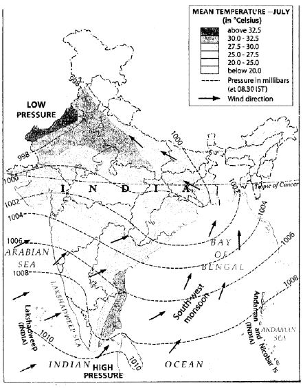
In simple words: The summer monsoon splits into two branches: one blows from the Arabian Sea onto the west coast, and the other blows from the Bay of Bengal into eastern and northern India.
Exam Tip: In maps, always show the Arabian Sea branch arrows coming from the southwest towards the west coast, and the Bay of Bengal branch curving northwest after entering through the delta region.
Question 2. Shade in yellow the rain shadow regions of the Western Ghats.
Answer: The leeward side of the Western Ghats, also known as the rain shadow area, is located immediately east of the mountain range. As the moist monsoon winds rise over the western slopes, they cool and shed most of their moisture, leaving very little rainfall for the eastern plains of the Deccan Plateau.
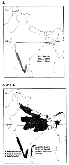
In simple words: The area just east of the Western Ghats gets very little rain because the mountains block the wet clouds, leaving a dry region shaded in yellow.
Exam Tip: The rain shadow region lies strictly to the east of the Western Ghats. Ensure you do not shade the coastal strip on the west, as it receives extremely heavy rainfall.
Question 4. Mark the Kaziranga and Kanha national parks, and the Nokrek biosphere reserve.
Answer: These key wildlife conservation areas are located across different geographical regions of India. Kanha National Park is found in Madhya Pradesh (central India), Kaziranga National Park is in Assam (northeast India), and Nokrek Biosphere Reserve is located in the Garo Hills of Meghalaya (northeast India).
In simple words: This map marks Kanha in central India, and Nokrek and Kaziranga close together in the northeastern part of the country.
Exam Tip: Make sure to place Kanha right in the middle of Madhya Pradesh, while Kaziranga and Nokrek should be marked in Assam and Meghalaya respectively in the northeast arm.
G. Picture Study

Question 1. Identify the type of forest shown in the photograph.
Answer: The photograph depicts a mangrove or tidal forest ecosystem.
In simple words: This picture shows a tidal or mangrove forest, which grows in coastal saltwater environments.
Exam Tip: Look for tangled, arched roots above the water line to easily identify a mangrove forest in picture-based questions.
Question 2. Write two characteristics of this type of forest.
Answer:
1. These forests are extremely dense and mainly comprised of tough hardwood tree species.
2. The trees are equipped with specialized stilt-like roots that grow above the muddy ground to absorb oxygen.
3. The foliage features shiny, evergreen leaves that help minimize moisture loss.
In simple words: These forests have thick, hard wood and special roots that arch out of the wet mud to breathe air. Their leaves are glossy and stay green all year.
Exam Tip: Mentioning the phrase "pneumatophores" or "breathing roots" along with "salinity tolerance" is highly recommended by examiners for top grades.
Extra Questions
Question 1. Which latitude divides India into two nearly equal parts ?
Answer: The Tropic of Cancer, positioned at \( 23\frac{1}{2}^\circ \text{ N} \) latitude, splits India into two nearly equal zones: the northern temperate belt and the southern tropical belt.
In simple words: The Tropic of Cancer is an imaginary line that cuts India right through the middle, separating the hot south from the cooler north.
Exam Tip: Always specify the exact degree of latitude (\( 23\frac{1}{2}^\circ \text{ N} \)) when naming the Tropic of Cancer to ensure full marks.
Question 2. What are monsoons ?
Answer: Monsoons are periodic, seasonal winds that sweep across the Indian subcontinent, bringing major rainfall phases to the entire nation.
In simple words: Monsoons are special winds that change direction with the seasons, carrying heavy rain clouds across India.
Exam Tip: The word "seasonal reversal of winds" is the critical geographical term examiners look for in a definition of monsoons.
Question 3. What are the factors affecting the climate of India ?
Answer: Several key geographic factors shape the Indian climate:
1. Latitude - Southern parts near the equator experience a warm, stable marine climate, whereas northern parts farther away experience extreme differences between summers and winters.
2. Elevation - Air temperatures decrease with height. Thus, elevated Himalayan zones and southern hill stations like Ooty and Kodaikanal maintain very cool climates.
3. Northern Mountains - The Himalayas serve as a shield against freezing Central Asian winds and simultaneously trap monsoon rain clouds within the country.
4. Proximity to the Sea - Inland areas like Punjab or Rajasthan have extreme, dry climates. In contrast, coastal cities like Chennai and Mumbai enjoy moderate temperatures year-round.
In simple words: India's weather is shaped by how close a place is to the equator, how high up it is, the shield of the Himalayas, and whether it is near the ocean.
Exam Tip: Structure your answer using clear bullet points with sub-headings like 'Latitude', 'Altitude', and 'Distance from Sea' to make it easy to read and grade.
Question 4. Why do places at higher altitudes and the coastal regions have moderate temperatures in summers ?
Answer: Elevated locations experience mild summer temperatures because atmospheric temperature naturally drops as altitude rises. Meanwhile, coastal territories benefit from the ocean's influence, which brings cool sea breezes that moderate summer temperatures.
In simple words: High places stay cool in summer because of their elevation, while beaches stay comfortable because of cool ocean breezes.
Exam Tip: Explain both mechanisms separately - the lapse rate for altitude and the land-sea breeze effect for coastal areas - to get maximum marks.
Question 5. Name :
1. The hottest place in India
2. The coldest place in India.
3. The wettest place in India.
Answer:
1. The warmest location in India is Briyawali in Bikaner, Rajasthan, where temperatures can hit \( 56^\circ\text{C} \).
2. The chilliest inhabited location is Dras in Jammu and Kashmir, with temperatures dropping to \( -56^\circ\text{C} \).
3. The wettest location is Mawsynram in Meghalaya, recording a massive average annual rainfall of 1,187 cm.
In simple words: The hottest spot is Briyawali in the Rajasthan desert, the coldest is Dras in Jammu and Kashmir, and the wettest is Mawsynram in Meghalaya.
Exam Tip: Make sure you can spell 'Mawsynram' and 'Briyawali' correctly, as spelling errors in place names can sometimes cost half a mark.
Question 6. What do you mean by western disturbances ?
Answer: Western disturbances are low-pressure cyclonic storms that start over the Mediterranean region and travel eastward into India. They are responsible for bringing vital winter rainfall to northwestern parts of the country.
In simple words: These are winter storms that travel all the way from the Mediterranean Sea to bring rain and snow to northwest India.
Exam Tip: Mention the 'Mediterranean Sea' as the origin of these cyclones, as this detail is essential for a complete answer.
Question 7. How are evergreen and deciduous trees different ?
Answer: Deciduous trees drop their leaves during dry seasons to minimize water loss (e.g., sal, teak, banyan, and sandalwood). Conversely, evergreen trees keep their green foliage all year long and do not experience a single shedding season (e.g., rosewood, ebony, mahogany, shisham, and bamboo).
In simple words: Deciduous trees lose all their leaves in the dry season to save water, while evergreen trees stay green and leafy all year.
Exam Tip: Be ready to provide at least two distinct examples of each tree type to support your comparison in long-answer formats.
Question 8. What do you mean by mangrove ?
Answer: A mangrove is a type of coastal forest found in tropical and subtropical regions that is regularly inundated by saline sea water during high tides.
In simple words: Mangroves are special coastal forests that can survive being flooded by salty ocean tides.
Exam Tip: Highlight the ability to tolerate high salinity and tidal flooding as the defining traits of mangrove vegetation.
Question 9. What is loo ?
Answer: The "Loo" refers to a powerful, blistering, and dusty summer wind that blows across the plains of northern India during the daytime.
In simple words: The Loo is a very hot and dusty dry wind that blows over north India during summer afternoons.
Exam Tip: Be sure to specify that the 'Loo' blows during the summer season and affects 'Northern India'.
Question 10. Name the showers that help in the ripening of mangoes in Kerala ?
Answer: These pre-monsoon rainfall events are locally called Mango showers.
In simple words: The early summer rains that help mangoes grow and ripen in Kerala are called Mango showers.
Exam Tip: Keep this answer direct and simple. These are also known as pre-monsoon showers.
Question 11. Why are storms in Assam and West Bengal called Kalbaisakhi ?
Answer: The term Kalbaisakhi translates to a calamity occurring in the month of Baisakh (April). This name is used because these fierce thunderstorms often bring severe damage to trees, crops, and local properties.
In simple words: Kalbaisakhi means a disaster in the month of April. They are named this because these severe spring storms can destroy houses and trees.
Exam Tip: Mentioning both the literal translation ('Calamity of Baisakh') and the timing ('April') will show a complete understanding of the term.
Question 12. Which is the first and the last state to receive monsoon in India ?
Answer: Kerala is the earliest state to receive the incoming monsoon rains, whereas Punjab is the final state to experience them.
In simple words: The monsoon rains start first in Kerala in early June and reach Punjab last in late July.
Exam Tip: Remember this spatial progression: monsoons enter from the extreme south (Kerala) and travel all the way to the northwest (Punjab).
Question 13. Name few festivals of India which celebrate the arrival of monsoons, changes in seasons and the harvest season.
Answer: Notable Indian seasonal celebrations include Pongal and Adi Perukku in Tamil Nadu, as well as Baisakhi in northern India.
In simple words: Festivals like Baisakhi in the north and Pongal and Adi Perukku in the south celebrate the harvest and changing seasons.
Exam Tip: Be sure to match the festival name with the correct region or state (e.g., Pongal in Tamil Nadu) for accuracy.
Question 14. What do you understand by retreating monsoons ?
Answer: Towards the close of September, the Indian landmass begins to cool down rapidly, causing the monsoon winds to lose moisture and dry up. A high-pressure system develops over the chilled land, while a low-pressure area remains over the warmer surrounding oceans. This thermal difference causes the dry winds to reverse their course, blowing back from the land towards the sea. This phase is known as the retreating monsoon.
In simple words: When the land cools down in autumn, dry winds turn around and blow back from the land toward the ocean. This is called the retreating monsoon.
Exam Tip: Highlight the transition from high pressure on land to low pressure over water bodies as the mechanical cause of this wind reversal.
Question 15. Why does Tamil Nadu receive rainfall in winter ?
Answer: During summer, Tamil Nadu remains dry because it lies in the leeward rain shadow of the Western Ghats, which blocks the southwest monsoon. In winter, however, dry winds blowing from the northeast cross the Bay of Bengal, picking up moisture. When these winds strike the coast of Tamil Nadu, they deliver significant winter precipitation as the northeast monsoon.
In simple words: In summer, mountains block the rain from reaching Tamil Nadu. In winter, winds blow over the ocean, pick up water, and dump it as rain on the Tamil Nadu coast.
Exam Tip: The combination of two factors - being in the rain shadow during summer and receiving moisture-laden northeast winds in winter - must be present for a complete mark.
Question 16. Name two area in India which receive winter rainfall.
Answer: The two primary regions that experience winter rains are northwestern India and the Coromandel Coast.
In simple words: Northwestern India and the southeast coast (Coromandel Coast) are the two main regions that get winter rain.
Exam Tip: These two areas receive winter rain from different sources: the northwest from western disturbances, and the Coromandel Coast from the northeast monsoon.
Question 17. On what factors does rainfall at a place depend on ?
Answer: Rainfall at any location is determined by its geographical position, such as whether it is situated near a coast or deep inland. It also depends heavily on whether the site lies on the windward (moist) or leeward (dry) side of mountain ranges, alongside the general orientation of those mountains.
In simple words: How much rain a place gets depends on its distance from the sea, which side of a mountain range it is on, and the direction of the mountains.
Exam Tip: Mentioning the words 'relief' or 'orographic' factors (windward vs. leeward) is key to writing an impressive answer.
Question 18. Write short notes on :
1. Thorn and Desert forest
2. Mountain or Alpine forest
3. Afforestation or Vana Mahotsava
Answer:
1. Thorn and Desert forest - Found primarily in northwestern India and on the dry leeward sides of the Western Ghats - including parts of Rajasthan, Punjab, Haryana, Madhya Pradesh, Maharashtra, Andhra Pradesh, and Gujarat. These areas receive under 50 cm of annual rainfall, leading to a thin, open canopy. The plant life is dominated by stunted, thorny trees and shrubs. To survive, these plants have evolved long taproots to draw deep groundwater and modified fleshy stems to store water. Common species include date palms, acacia, palas, cacti, kikar, and babool.
2. Mountain or Alpine forest - Mainly situated in the Himalayan heights of Jammu and Kashmir, Himachal Pradesh, Uttarakhand, and Arunachal Pradesh. The vegetation changes dramatically with altitude: the lower foothills feature deciduous trees, the middle slopes host mixed deciduous and coniferous trees, and the high slopes are covered in alpine grasslands. Coniferous forests contain softwoods like silver fir, chir pine, deodar, cedar, beech, ash, oak, and chestnut.
3. Afforestation or Vana Mahotsava - Vana Mahotsava is India's annual tree-planting movement aimed at restoring ecological balance and combatting atmospheric depletion. The key activities undertaken include:
(a) Planting new trees to boost total forest area.
(b) Caring for previously planted trees.
(c) Protecting growing forests from pest infestations.
(d) Afforesting barren wastelands and steep mountain slopes.
(e) Preventing illegal timber cutting and forest clearing.
(f) Distributing saplings for free to promote community planting.
In simple words: Thorn forests are dry, scrubby areas in desert states; mountain forests change from leafy to pine trees as you climb; Vana Mahotsava is an annual festival dedicated to planting and protecting trees.
Exam Tip: For the 'Thorn and Desert forest' note, always mention water-saving adaptions like long roots and modified stems to demonstrate ecological knowledge.
Question 19. Name few important species of wildlife found in India.
Answer: India boasts a vast array of unique fauna.
Some of the key animal species include the Royal Bengal tiger, Asiatic lion, snow leopard, panther, cheetah, Indian elephant, Nilgai (blue bull), barasingha, swamp deer, hangul, red panda, Himalayan black bear, one-horned rhinoceros, as well as marsh crocodiles and gharials.
Prominent bird species found in the country include the mynah, swallow, owl, parrot, kite, dove, pigeon, sparrow, bulbul, goose, duck, kingfisher, heron, and crane.
In simple words: India is home to amazing animals like Bengal tigers, Asiatic lions, and rhinos, along with many birds like kingfishers, parrots, and peacocks.
Exam Tip: Group your answer into 'Mammals/Animals' and 'Birds' to show neat, structured presentation that examiners prefer.
Question 20. List some direct and indirect advantages from forests.
Answer: Forests provide numerous vital benefits to humans and the environment:
Direct Advantages:
1. They supply valuable timber for building homes, making furniture, toys, railway ties, sporting equipment, and carvings. They also provide softwoods, bamboo, and wild grasses to make paper and plywood.
2. They yield essential non-timber products like wild fruits, flowers, medicinal herbs, beeswax, honey, turpentine, lac, and natural resins.
3. They offer nutritious green fodder for domestic livestock.
4. They act as critical natural sanctuaries and homes for diverse wildlife.
5. They are major scenic attractions that drive ecotourism.
Indirect Advantages:
1. Forests moderate local weather, keeping temperatures balanced.
2. They anchor the soil, preventing erosion by slowing the flow of heavy rain and floodwaters.
3. They enrich the earth's fertility by contributing organic matter and humus.
4. They release water vapor through transpiration, which helps in cloud formation and triggers rain.
In simple words: Directly, forests give us wood, paper, medicine, food, and tourist spots. Indirectly, they clean the air, stop floods, keep soil rich, and bring rain.
Exam Tip: Clearly separate your answer into 'Direct' (tangible goods we get) and 'Indirect' (ecological benefits) sections to ensure you meet all scoring points.
Question 21. Define with examples :
1. Sanctuary
2. National Park
3. Biosphere reserve.
Answer:
1. Sanctuary - A protected wildlife reserve where animals are preserved in their natural environment. Activities like hunting, carrying weapons, starting fires, or introducing harmful materials are banned. Limited human acts like controlled grazing or tourist photography are permitted with approval. Examples: Sultanpur and Periyar bird sanctuaries.
2. National Park - A highly protected ecosystem where animals are kept completely safe from human interference. Grazing and all commercial resource collection are strictly illegal. Tourists may enter under strict regulations. Examples: Jim Corbett, Gir, and Kaziranga national parks.
3. Biosphere reserve - Extensive conservation areas meant to preserve entire ecosystems and their genetic diversity, while offering opportunities for research and community-based sustainable living. Examples: Nanda Devi and Sunderbans biosphere reserves.
In simple words: Sanctuaries are safe areas where limited human activity is allowed; National Parks are strictly protected zones with no grazing; Biosphere Reserves are huge areas protecting entire habitats and local communities.
Exam Tip: Know the difference in human activity levels allowed: Sanctuaries have moderate restrictions, National Parks have high restrictions, and Biosphere Reserves integrate local communities.
Fill in the blanks
Question 1. The areas away from the coast experience _________ of temperature while those near the coast have _________ climate throughout the year.
Answer: extremes, equable
In simple words: Places far from the ocean get very hot or very cold, while coastal places stay comfortable all year.
Exam Tip: Remember 'extremes' refers to continental climates, while 'equable' refers to moderate maritime climates.
Question 2. The southern part of India is _________ all year round.
Answer: warm
In simple words: Southern India stays warm throughout the year because it is close to the equator.
Exam Tip: Proximity to the equator keeps the annual temperature range in southern India very narrow and warm.
Question 3. Agriculture, forestry and fishing are directly influenced by the amount of _________.
Answer: rainfall
In simple words: Farming, forest growth, and fishing rely heavily on how much rain a region gets.
Exam Tip: Water availability from rainfall is the primary driver for primary sector economic activities in India.
Question 4. Temperature _________ with increase in height above sea level.
Answer: decreases
In simple words: As you go higher up a mountain, the air gets colder.
Exam Tip: This relationship is known as the lapse rate, where temperature drops as elevation rises.
Question 5. The _________ protect our country from the cold winds of Central Asia.
Answer: Himalayas
In simple words: The high Himalayan mountains block freezing winds from Central Asia from entering India.
Exam Tip: The Himalayas act as a vital climatic barrier, keeping the Indian subcontinent warmer in winter than other regions at the same latitude.
Question 6. The highest temperatures are recorded in the _________ regions of north-west India.
Answer: desert
In simple words: The hottest parts of India are located in the desert areas in the northwest.
Exam Tip: The Thar Desert in Rajasthan records some of the highest temperatures in India due to dry sand and clear skies.
Question 7. The winter rainfall is very important for the cultivation of _________ crops such as wheat.
Answer: rabi
In simple words: Winter rain is very helpful for winter-sown crops like wheat, which are called rabi crops.
Exam Tip: Rabi crops are sown in winter. The rains from western disturbances are critical for their success.
Question 8. The _________ branch of south-west monsoon winds cause heavy rainfall to Western Ghats.
Answer: Arabian Sea
In simple words: The wind branch coming from the Arabian Sea brings heavy rain to the west coast mountains.
Exam Tip: The Arabian Sea branch hits the Western Ghats first, causing intense orographic (relief) rainfall on their western slopes.
Question 9. The _________ branch of south-west monsoon bring heavy rainfall to the north-east India Ganga plains and north-west India.
Answer: Bay of Bengal
In simple words: The wind branch blowing over the Bay of Bengal brings heavy rain to eastern, northeastern, and northern India.
Exam Tip: Remember that the Bay of Bengal branch is deflected westward by the Himalayas, bringing rain along the Ganga plains.
Question 10. There are about _________ species of plants and animals in India.
Answer: 5,000
In simple words: India is home to several thousand unique types of plants and animals.
Exam Tip: Use the exact figure of '5,000' as specified in this textbook's curriculum notes.
Question 11. Mangrove forests are a very important part of the _________ ecosystem.
Answer: coastal
In simple words: Mangrove forests are extremely important for protecting beaches and coastal environments.
Exam Tip: Mangroves act as a buffer against coastal erosion, tsunamis, and storm surges.
Question 12. _________ is the national animal and _________ is the national bird of India.
Answer: Tiger, peacock
In simple words: The tiger is India's national animal, and the peacock is its national bird.
Exam Tip: This is a simple GK question; make sure to write the names clearly without spelling errors.
Question 13. The total forest area in India was at _________ per cent in 2015.
Answer: 21.34
In simple words: In 2015, about one-fifth (21.34%) of India's land was covered by forests.
Exam Tip: Memorize this specific percentage (21.34%) for questions relating to forest statistics in India.
Question 14. There are _________ wildlife sanctuaries and _________ national parks in India.
Answer: 514, 100
In simple words: India has 514 wildlife sanctuaries and 100 national parks to protect nature.
Exam Tip: Be sure to keep the numbers correct: 514 sanctuaries and 100 national parks according to these textbook figures.
Question 15. India receives most of its rainfall from the _________ monsoons from June to October.
Answer: south-west
In simple words: Most of India's rain falls between June and October from winds blowing from the southwest.
Exam Tip: The south-west monsoon is the primary source of water for India's agricultural economy.
Question 16. The _________ monsoons cause rainfall on the Coromandel Coast during winter months.
Answer: north-east
In simple words: In winter, winds blowing from the northeast bring rain to the southeast coast of India.
Exam Tip: The Coromandel Coast of Tamil Nadu uniquely receives its peak rainfall during winter from the retreating or north-east monsoons.
Question 17. The _________ cause rainfall in the north-west India in winters.
Answer: western disturbances
In simple words: Storms from the west, called western disturbances, bring winter rain to northwestern India.
Exam Tip: Western disturbances originate in the Mediterranean and are crucial for irrigation of rabi crops.
Map Skills
Question 1. Mark some important biosphere reserves, bird sanctuaries and national parks of India ?
Answer: India has established numerous protected zones to preserve its unique ecosystems. These include Dachigam in Jammu and Kashmir (North), the Gir Forest in Gujarat (West), Kanha in Madhya Pradesh (Central), Kaziranga in Assam (Northeast), the Sunderbans in West Bengal (East), and Periyar in Kerala (South).
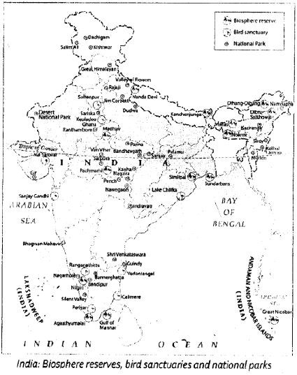
In simple words: This map marks some of India's most famous wildlife parks, such as Dachigam in the north, Gir in the west, Kanha in the center, Sunderbans and Kaziranga in the east, and Periyar in the south.
Exam Tip: Be ready to identify these critical reserves on a blank map by remembering their corresponding states.
Question 2. On an outline map of India, show the path of the north - east monsoons with arrows.
Answer: During winter, the northeast monsoon winds blow from the high-pressure landmass of Central Asia and northern India toward the low-pressure oceanic regions. These winds travel over land, making them mostly dry, but they pick up moisture as they cross the Bay of Bengal, bringing winter rains to the southeastern coast of India (specifically Tamil Nadu).
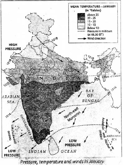
In simple words: The northeast monsoon winds blow from the cold northern land down towards the warm ocean, picking up water as they cross the Bay of Bengal to bring winter rain to the southeast coast.
Exam Tip: Draw the arrows pointing from the northeast (land) towards the southwest (ocean) to correctly indicate winter wind patterns.
Question 3. On an outline map of India, show the annual distribution of rainfall.
Answer: Precipitation across India varies dramatically. Regions with heavy rainfall (above 200 cm) include the Western Ghats and northeastern India. Moderate rainfall regions (100-200 cm) cover central and eastern India. Low rainfall areas (below 100 cm) are situated in parts of the Deccan Plateau and northwestern India, with the lowest values (under 60 cm) recorded in the Thar Desert and cold desert of Ladakh.
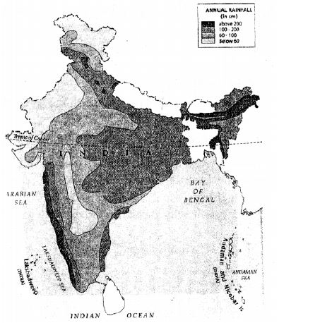
In simple words: This map shows that western coastlines and northeastern states get heavy rain, central India gets moderate rain, and western deserts get very little.
Exam Tip: Be sure to distinguish between coastal areas (which receive high rainfall) and interior areas (which receive much lower precipitation).
Free study material for Geography
ICSE Textbook Solutions for Class 8 Geography Chapter 10 India Climate Natural Vegetation Forests And Wildlife
ICSE Chapter Solutions: Class 8 Geography Chapter 10 India Climate Natural Vegetation Forests And Wildlife
Strengthen your preparation with comprehensive answers for Class 8 Geography Chapter 10 India Climate Natural Vegetation Forests And Wildlife. These expert-reviewed solutions make tracking your academic progress straightforward and efficient.
Step-by-Step Explanations and Breakdown
Verify your answers instantly using the comprehensive breakdowns provided for each problem, ensuring complete syllabus coverage across all sub-topics.
More Study Resources for Class 8 Geography
Pair your solution review with additional practice papers to test your execution speed and ensure total preparedness for school exams.
FAQs
You can download the verified Voyage solutions for Chapter 10 India Climate Natural Vegetation Forests And Wildlife on StudiesToday.com. Our teachers have prepared answers for Class 8 Geography as per 2026-27 ICSE academic session.
Yes, our solutions for Chapter 10 India Climate Natural Vegetation Forests And Wildlife are designed as per new 2026 ICSE standards. 40% competency-based questions required for Class 8, are included to help students understand application-based logic behind every Geography answer.
Yes, every exercise in Chapter 10 India Climate Natural Vegetation Forests And Wildlife from the Voyage textbook has been solved step-by-step. Class 8 students will learn Geography conceots before their ICSE exams.
Yes, follow structured format of these Voyage solutions for Chapter 10 India Climate Natural Vegetation Forests And Wildlife to get full 20% internal assessment marks and use Class 8 Geography projects and viva preparation as per ICSE 2026 guidelines.