

Class 8 Geography Chapter 07 Asia Location Extent Political And Physical Features: Voyage Study Material
Access the official Voyage textbook solutions for Class 8 Geography, updated for the 2026-27 academic year. This digital resource is structured to help students build strong conceptual clarity and prepare effectively for school examinations.
Chapter 07 Asia Location Extent Political And Physical Features Answer Guide
Access the complete PDF for Chapter 07 Asia Location Extent Political And Physical Features below. This focused excerpt allows students to isolate specific topics for thorough review and uninterrupted reading, complementing standard ICSE textbooks.
A. Fill in the blanks
Question 1. A mountain range in South-west Asia that separates Asia from Europe.
Answer: Caucasus mountains.
In simple words: The Caucasus mountains act as a natural wall between southwest Asia and Europe.
Exam Tip: Remember that this range is one of the key physical borders separating Asia from the European continent.
Question 2. I am a plain formed by the rivers Ob, Yenisei, and Lena.
Answer: Great Siberian Plain or Northern Lowlands.
In simple words: The Great Siberian Plain, which is also called the Northern Lowlands, is formed by these rivers.
Exam Tip: Always associate the Ob, Yenisei, and Lena rivers with the northern part of Asia.
Question 3. An area of inland drainage into which the Amu Darya and, Syr Darya drain.
Answer: Turan Plain.
In simple words: The Turan Plain is the basin where both of these rivers empty.
Exam Tip: Inland drainage means the rivers do not reach the open ocean but empty into an inland lake or basin.
Question 4. I am a small zone from which several mountain ranges appear to radiate out.
Answer: Pamir Knot.
In simple words: The Pamir Knot is the central highland where these mountain chains meet and spread out.
Exam Tip: Think of a knot as a starting point where multiple strings, or in this case mountain ranges, tie together.
Question 5. A plateau that lies between the Alborz and Zagros mountain ranges.
Answer: Plateau of Iran.
In simple words: The Plateau of Iran is the flat highland situated between these two mountain walls.
Exam Tip: Inter-mountain plateaus are surrounded by mountain ranges. The Alborz and Zagros are the ranges for the Iranian Plateau.
B. Match the following
Question. Match the items in column A with the correct choices in column B:
| A | B |
|---|---|
| 1. Population of Asia | a. Manchurian Plain |
| 2. Countries in Asia | b. Plateau of Tibet |
| 3. Marshy lowlands | c. 4.43 billion people |
| 4. Inter-montane plateau | d. 48 |
| 5. River Amur | e. Great Siberian Plain |
Answer:
| A | B |
|---|---|
| 1. Population of Asia | c. 4.43 billion people |
| 2. Countries in Asia | d. 48 |
| 3. Marshy lowlands | e. Great Siberian Plain |
| 4. Inter-montane plateau | b. Plateau of Tibet |
| 5. River Amur | a. Manchurian Plain |
In simple words: This exercise matches important facts about Asian geography, like the population and physical features, with their correct names.
Exam Tip: When solving match-the-following questions, start with the easiest pairs first, like the total number of countries or the population figure, to eliminate options.
C. State whether the following are true or false
Question 1. Together with Europe, Asia is often referred to as Eurasia.
Answer: True.
In simple words: Asia and Europe form one continuous landmass known as Eurasia.
Exam Tip: Eurasia is a portmanteau word combining 'Europe' and 'Asia'.
Question 2. Most of the Asian countries gained independence only after World War I.
Answer: False.
In simple words: Most countries in Asia became independent after World War II.
Exam Tip: Remember that major decolonization in Asia occurred in the late 1940s and 1950s, which was after the end of World War II.
Question 3. Three rivers which flow northwards into the Arctic Ocean are the Ganga, the Brahmaputra and the Yamuna.
Answer: False.
In simple words: The three main rivers flowing north into the Arctic Ocean are the Ob, Yenisei, and Lena.
Exam Tip: Rivers like the Ganga and Brahmaputra flow southwards into the Indian Ocean (Bay of Bengal), not northwards into the Arctic Ocean.
Question 4. The Karakoram Range is a short range, which extends south-eastwards from the Pamir Knot between the Kunlun and the Himalayas.
Answer: True.
In simple words: This mountain range stretches southeast from the Pamir Knot. It lies between the Kunlun and Himalayan mountains.
Exam Tip: Keep the spatial layout of these northern mountain ranges in mind when studying the physical features of Asia.
Question 5. The Deccan Plateau of India lies between the Western Ghats and the Eastern Ghats.
Answer: True.
In simple words: The Deccan Plateau in India is located in the middle of the Western and Eastern Ghats.
Exam Tip: Visualizing a physical map of India can help you remember that the Ghats flank the Deccan Plateau on both sides.
D. Answer the following questions in brief
Question 1. Name the geographical features that border Asia in the north, south, east, and west.
Answer: Asia is surrounded by different natural boundaries. On the west, the Caspian Sea and Ural mountains separate it. To the southwest are the Caucasus Mountains. The Arctic Ocean is at the north, the Pacific Ocean lies to the east, and the Indian Ocean is located to the south.
In simple words: Asia is bordered by the Arctic Ocean on the north, the Pacific Ocean on the east, the Indian Ocean on the south, and mountains and seas on the west.
Exam Tip: Draw a simple directional compass (N, S, E, W) to help you memorize which water bodies or mountains border Asia on each side.
Question 2. What do you understand by the term ‘archipelago ? Give two examples from the Pacific Ocean.
Answer: An archipelago is defined as a cluster or chain of islands. Two great island groups in the Pacific Ocean are Japan and the Philippines.
In simple words: An archipelago is just a group of many islands that are close to each other in the ocean.
Exam Tip: Be sure to define the term first before providing the specific examples requested by the question.
Question 3. Name the rivers of the Great Siberian Plain.
Answer: The Ob, Yenisei, and Lena rivers worked together to form the Great Siberian Plain.
In simple words: These three big rivers flow through northern Asia and built up the flat Siberian land.
Exam Tip: Remember these three rivers as a group, as they are the primary rivers draining the northern lowlands of Asia.
Question 4. What kind of plateau is the Plateau of Tibet ?
Answer: The Plateau of Tibet is an inter-mountain plateau, which means a flat highland trapped between mountain walls. It is located between the Himalayas and the Kunlun mountains. It is the highest flat land on Earth. People call it the 'Roof of the World'.
In simple words: This plateau is called an inter-mountain plateau because it lies between high mountain ranges. It is the highest flat area in the world.
Exam Tip: Make sure to mention the specific ranges (Kunlun and Himalayas) that surround this plateau to secure full marks.
Question 5. In which country of Asia are the Mesopotamian plains situated ?
Answer: These plains are located in the country of Iraq.
In simple words: The famous Mesopotamian plains are found in modern-day Iraq.
Exam Tip: Note the spelling of 'Mesopotamian' carefully as it is a common point for spelling mistakes.
E. Answer the following questions in detail
Question 1. Describe the location of Asia.
Answer: Almost all of Asia sits in the northern and eastern hemispheres. On the west, the Ural Mountains and Caspian Sea divide it from Europe. In the southwest, the Caucasus Mountains form the border. Oceans surround Asia on three sides. The Arctic Ocean is to the north. The Pacific Ocean is to the east. The Indian Ocean lies to the south.
From north to south, Asia stretches from 10°S to 80°N. This distance is about 8,690 km. From west to east, it spans 9,700 km, from 25°E to around 170°W. There are 48 independent countries in Asia. They vary greatly in size. Russia, China, and India are the largest. Singapore, the Maldives, and Bahrain are the smallest. Some countries are made of island groups, like Japan, Indonesia, and the Philippines.
In simple words: Asia is located mostly in the top-right part of the world. It is surrounded by three oceans and is home to 48 countries of very different sizes.
Exam Tip: For detailed questions, break your answer into clear points: write about the hemispheres and borders first, and then list the latitudinal coordinates and country details.
Question 2. Describe the Northern Lowlands of Asia.
Answer: The Northern Lowlands of Asia stretch from the western Urals to the Bering Strait. This flat land has a triangular shape. It is widest in the west. The Arctic Ocean is on the north, and high mountains are on the south. This region is the largest continuous plain on Earth.
Three major rivers flow north into the Arctic Ocean. These are the Ob, Yenisei, and Lena rivers. Together, they built this plain. The land is very wet and swampy. It is also called the Great Siberian Plain.
In winter, the lower parts of the rivers freeze. Water from the warmer south cannot escape. It floods across the flat plains. South of this area lies the Turan Plain. This is a low basin with inland drainage. The Syr Darya and Amu Darya rivers flow into it.
In simple words: The Northern Lowlands are a giant, flat, and swampy area in northern Asia. Rivers flowing north built this land, but they freeze in winter and cause floods.
Exam Tip: Mention the seasonal freezing of the rivers and the resulting floods, as this is a key geographical feature of the Siberian Plain.
Question 3. Explain why the Pami Knot is called so. Write briefly about the mountain ranges that radiate from the Pamir Knot.
Answer: The Pamir Knot gets its name because many mountain ranges spread out from it. It looks like threads tied in a knot. To the east lie the Kunlun mountains. To the north are the Tien Shan mountains. The Himalayas stretch to the southeast. The Karakoram Range also goes southeast. It sits between the Himalayas and the Kunlun mountains. The Hindu Kush range lies to the west. The Sulaiman range runs to the southwest.
In simple words: The Pamir Knot is like a central hub where several of Asia's highest mountain chains connect and spread out in different directions.
Exam Tip: Learn the directions of the radiating ranges (East, North, Southeast, West, Southwest) and list them systematically in your answer.
Question 4. Write briefly about the Arabian Plateau and the Deccan Plateau.
Answer: The Arabian Plateau is steep in the west. It slopes down gently toward the Persian Gulf in the east. It is a very dry region with low rainfall and no rivers. It became very important after oil was found there in the 20th century.
The Deccan Plateau in India lies between the Western and Eastern Ghats. It is steep and high near the Arabian Sea. It slopes gently toward the Bay of Bengal in the east. Many rivers flow across this plateau. These include the Godavari, Krishna, and Kaveri.
In simple words: The Arabian Plateau is a dry desert area famous for its oil. The Deccan Plateau is located in India between two mountain ranges and has many rivers flowing through it.
Exam Tip: Contrast the two plateaus by comparing their water sources - the Arabian Plateau has no rivers, while the Deccan Plateau is drained by multiple perennial rivers.
Question 5. Describe the river valleys of Asia.
Answer: Melting mountain snow feeds great rivers in Asia. These rivers create very fertile and crowded valleys. Here are the main river valleys:
1. The Mesopotamian plains in Iraq lie between the Tigris and Euphrates rivers.
2. The Ganga - Brahmaputra plains cover northern India and Bangladesh. The Ganga and Brahmaputra rivers formed them.
3. The plains of China were built by the Huang He, Chang Jiang, and Si Kiang rivers.
4. The Manchurian Plain was created by the Amur River.
5. The plains of Indo - China were formed by the Mekong and Menam rivers.
6. The large plain in Myanmar was built by the Irrawaddy River.
7. The plains of Pakistan and Punjab were built by the Indus River and its five branches.
In simple words: Rivers that flow from high mountains create flat, rich plains. These areas are excellent for farming, so millions of people live there.
Exam Tip: Match each plain with its respective rivers carefully. Keeping this list memorized is very helpful for short-answer questions as well.
F. Picture study
The mountain peak shown in the picture is the tallest peak in the world.
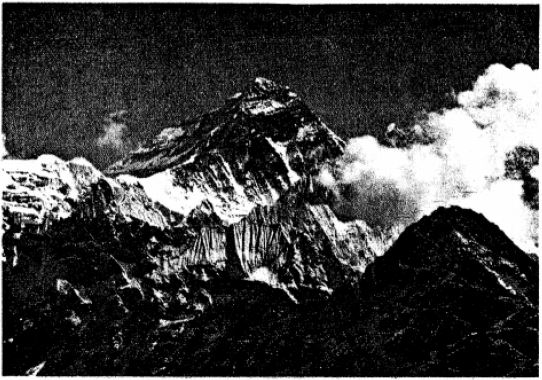
Question 1. What is the height of this peak ?
Answer: The height of this peak is 8,850 m.
In simple words: The mountain stands 8,850 meters tall above sea level.
Exam Tip: Always write the unit 'm' (meters) next to the number when writing mountain heights.
Question 2. In which mountain range does it lie ?
Answer: It lies in the Himalayas.
In simple words: This peak is located in the Himalayan mountain range.
Exam Tip: Capitalize 'Himalayas' since it is a proper geographic noun.
G. Map study
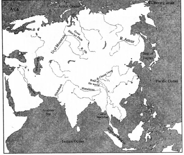
Question. On an outline map of Asia, mark and name the following:
1. Rivers - Amur, Ob, Chang Jiang
2. Gulfs - Persian Gulf, Gulf of Martaban
3. Straits - Bering Strait, Strait of Malacca
4. Seas - Arabian Sea, Caspian Sea, Sea of Japan
5. Oceans - Arctic, Pacific, Indian
6. Mountain ranges - Himalayas, Urals, Hindukush
7. Write ROOF OF THE WORLD and GREAT SIBERIAN PLAIN in appropriate places on the map.
Answer: Refer to a physical map of Asia to locate and mark these features:
- Ob River: Mark this in northern Russia, flowing northwards into the Arctic Ocean.
- Amur River: Mark this in East Asia along the border of Far East Russia and China.
- Chang Jiang: Mark this running horizontally across central China.
- Persian Gulf: Locate this in West Asia, between Saudi Arabia and Iran.
- Gulf of Martaban: Mark this in the southern coastal curve of Myanmar.
- Bering Strait: Mark this in the far northeast corner, separating Asia from North America.
- Strait of Malacca: Locate this narrow channel between the Malay Peninsula and Sumatra.
- Arabian Sea: Mark this water body on the western side of the Indian peninsula.
- Caspian Sea: Mark the large landlocked sea situated west of Central Asia.
- Sea of Japan: Locate this sea between Japan and the Asian mainland.
- Oceans: Label the Arctic Ocean in the north, the Pacific Ocean in the east, and the Indian Ocean in the south.
- Mountain Ranges: Mark the Urals along the western edge of Russia, the Himalayas north of India, and the Hindukush in Afghanistan.
- Roof of the World: Write this label over the Plateau of Tibet.
- Great Siberian Plain: Write this label across the wide flat lowlands of northern Russia.
In simple words: Use a blank map of Asia to practice finding and labeling these major rivers, mountains, and seas.
Exam Tip: Use a sharp pencil and write in neat block letters. This keeps your map clean and easy for the examiner to read.
Extra Questions
Question 1. What do you mean by Eurasia ?
Answer: Eurasia is the name given to the single landmass that contains both Europe and Asia. (Europe + Asia - Eurasia)
In simple words: Eurasia is the giant piece of land made up of both Europe and Asia.
Exam Tip: Use the simple addition formula (Europe + Asia = Eurasia) as a quick way to define this term.
Question 2. What are perennial rivers ?
Answer: Perennial rivers are those that flow continuously throughout the year, even during the dry season.
In simple words: These are rivers that always have water flowing in them and never dry up.
Exam Tip: Make sure to mention that these rivers maintain water flow even in the dry season to get full marks.
Question 3. Name the five physical regions of Asia.
Answer: Asia is divided into five main physical zones:
1. The Northern Lowlands (also called the Great Siberian Plain)
2. The Central Fold Mountains and Inter-montane Plateaus
3. The Southern Plateaus
4. The Great River Valleys
5. The Island Chains
In simple words: Asia has five main types of land, which include low plains, high mountains, plateaus, river valleys, and chains of islands.
Exam Tip: Memorizing these five regions helps build a strong foundation for any essay-style question on Asia's geography.
Question 4. Which mountain range has some of the world’s highest peaks ?
Answer: The Karakoram Range contains several of the tallest peaks on Earth.
In simple words: The Karakoram Range is home to some of the highest mountains in the world.
Exam Tip: K2, the world's second-highest peak, is located in this range.
Question 5. Name the plateaux (plural of plateau) of the Southern Plateaux of Asia.
Answer: The Southern Plateaux are made up of the Deccan Plateau, the Arabian Plateau, the Shan Plateau, and the Yunnan Plateau.
In simple words: The four major plateaus in the south of Asia are the Arabian, Deccan, Shan, and Yunnan plateaus.
Exam Tip: Capitalize the names of all four plateaus since they are proper names of geographic regions.
Question 6. Name the rivers that have built the Great River Valleys of Asia.
Answer: The primary river valleys of Asia were built by the Tigris, Euphrates, Indus, Ganga, Brahmaputra, Chao Phraya (or Menam), Chang Jiang (or Yangtze), Huang He, and Si Kiang rivers. Smaller plains are also formed by the Irrawaddy, Salween, Mekong, and Amur rivers.
In simple words: Massive river plains in Asia were created over time by famous rivers like the Tigris, Indus, Ganga, and Yangtze.
Exam Tip: Grouping the rivers by region (like South Asia or East Asia) makes it much easier to memorize this long list.
Question 7. Write a note on the Island Chains of Asia.
Answer: A series of island chains lies to the east and southeast of the Asian mainland, forming arc-shaped groups of islands called archipelagos. Starting from the tip of the Kamchatka Peninsula, these include the Kuril Islands, the Japanese Islands (made up of Hokkaido, Honshu, Shikoku, and Kyushu), the Ryukyu Islands, the Philippines, and the Indonesian Islands. In the southern region of the continent, we find the Andaman and Nicobar Islands, Sri Lanka, the Maldives, and the Lakshadweep Islands.
In simple words: Curved chains of islands sit off the eastern and southern coasts of Asia. These include countries like Japan, Indonesia, and the Philippines, as well as islands near India like Sri Lanka.
Exam Tip: Separate your answer into islands located in the Pacific Ocean (East/Southeast Asia) and islands in the Indian Ocean (South Asia) to show clear structure.
Question 8. Which is the largest and the smallest country in Asia ?
Answer: Russia is the largest country in Asia, while the Maldives is the smallest.
In simple words: Russia is the biggest nation on the continent, and the Maldives is the tiniest.
Exam Tip: These facts are very common in one-word answers or multiple-choice questions.
Question 9. Name the following (in Asia):
1. Most industrialized country -
2. Highest elevation
3. Highest Plateau
4. Lowest point
5. Deepest sea
6. Deepest lake
7. Longest strait
8. Coldest Place
9. Warmest place
10. Number of countries in Asia
Answer:
1. Japan is the most industrialized nation.
2. Mount Everest (8,850 m) has the highest elevation.
3. The Plateau of Tibet, widely known as 'The Roof of the World', is the highest plateau.
4. The Dead Sea, which lies 400 meters below sea level, is the lowest point.
5. The deepest body of water classified as a sea is the South China Sea.
6. Lake Baikal is the deepest lake.
7. The Strait of Malacca is the longest strait.
8. Verkhoyansk in Russia is the coldest place, reaching temperatures of -70°C.
9. Dasht-e Lut in Iran is the warmest location.
10. There are 48 independent countries.
In simple words: This list highlights the record-breaking places in Asia, such as its highest mountains, lowest seas, and coldest spots.
Exam Tip: Make quick flashcards with these geographic extremes to help with last-minute revision before exams.
Question 10. What are the six regional divisions of Asia ?
Answer: The six major geographic divisions of Asia are:
1. East Asia: This includes nations like China, Japan, Mongolia, North Korea, South Korea, and Taiwan.
2. North Russia: This area comprises the Asian territory of Russia, which covers Siberia and the Russian Far East.
3. Central Asia: This division contains landlocked nations such as Kazakhstan, Uzbekistan, Kyrgyzstan, Tajikistan, Turkmenistan, and Afghanistan.
4. South-East Asia: This region is split into two parts. The mainland northern section contains Myanmar, Thailand, Cambodia, Laos, and Vietnam. The southern island section includes Malaysia, Singapore, Brunei, Indonesia, East Timor, and the Philippines.
5. South Asia: This region is made up of India, Pakistan, Bangladesh, Nepal, Bhutan, Sri Lanka, and the Maldives.
6. West Asia: This division consists of countries like Saudi Arabia, Iran, Iraq, Turkey, Israel, Jordan, Syria, Yemen, Oman, UAE, Qatar, Kuwait, Bahrain, Lebanon, Cyprus, Georgia, Armenia, and Azerbaijan.
In simple words: Asia is split into six smaller regions based on where the countries are located, such as East Asia, South Asia, and West Asia.
Exam Tip: Try to remember at least three major countries for each of the six regional divisions to support your answer.
Question 11. Name some important cities of East Asia.
Answer: Some of the most active and busy cities in East Asia include Tokyo, Beijing, Shanghai, and Hong Kong.
In simple words: Busy cities like Tokyo, Beijing, and Shanghai are in East Asia.
Exam Tip: Capitalize the names of these major cities since they are proper nouns.
Question 12. Which are the two main rivers of Central Asia and why are they important ?
Answer: The Amu Darya and the Syr Darya are the two primary rivers in Central Asia. They are critical because much of this region is extremely dry throughout the year, with deserts covering about 60% of the land.
In simple words: These two rivers are vital because they bring fresh water to a region that is mostly dry desert.
Exam Tip: Mention the statistic that 60% of Central Asia is desert to emphasize why these rivers are so important.
Question 13. Write a short note on South Asia.
Answer: South Asia is the southern region of the continent, comprising India, Pakistan, Bangladesh, Nepal, Bhutan, Sri Lanka, and the Maldives. It is the most crowded region on Earth, holding nearly one-fifth of the global population. This territory is bounded by the Himalayas in the north, the Indian Ocean in the south, the Bay of Bengal in the east, and the Arabian Sea in the west. The area boasts a rich diversity of plants and animal species.
In simple words: South Asia contains countries like India and Pakistan. It is a crowded region bordered by high mountains and oceans.
Exam Tip: Be sure to list the physical boundaries (Himalayas, Indian Ocean, etc.) as they are major geographical markers for South Asia.
Question 14. Why is West Asia not densely populated ?
Answer: The population density in West Asia is low due to its harsh and dry climate.
In simple words: Not many people live in West Asia because the weather there is extremely hot and dry.
Exam Tip: Always link low population density directly to the desert conditions and low water availability of the region.
Question 15. Why is the Plateau of Tibet called the ‘Roof of the World’?
Answer: This plateau is referred to as the 'Roof of the World' because it is the tallest flat area on Earth, sitting at an average elevation of 4,880 meters.
In simple words: It gets this nickname because it is the highest flat region in the world.
Exam Tip: Including the average height of 4,880 m in your answer shows excellent detail and will secure full marks.
Question 16. Which is the highest and the second highest peak in the world and where are they situated ?
Answer: Mount Everest, standing at 8,850 meters in the Himalayan range, is the tallest peak on Earth. The second tallest peak is K2, also known as Godwin Austen, which reaches 8,611 meters and is located in the Karakoram range.
In simple words: Mount Everest is the highest mountain, and K2 is the second highest.
Exam Tip: Don't forget to name the respective mountain range for each peak (Himalayas for Everest, Karakoram for K2).
Question 17. Name few glaciers found in Himalayas and Karakoram range of mountains.
Answer: Two prominent glaciers in these regions are the Siachen glacier and the Baltoro glacier.
In simple words: The Siachen and Baltoro glaciers are huge blocks of ice found in these high mountains.
Exam Tip: Be sure to write the names of both glaciers to provide a complete answer.
Question 18. Name few passes in the Central Fold Mountains and Inter - Montane Plateaux which allow the movements of goods and people across the mountains.
Answer: Important mountain passes that help people and goods cross these barriers include the Khyber Pass, the Bolan Pass, and the Solan Pass.
In simple words: Passes are narrow paths through high mountains that let people and goods cross from one side to the other.
Exam Tip: Mentioning the Khyber Pass is very important as it is historically one of the most famous routes into South Asia.
Question 19. Why did the Arabian Plateau become important to the rest of the world ?
Answer: The global significance of the Arabian Plateau grew tremendously in the 20th century following the discovery of massive petroleum reserves.
In simple words: This plateau became very important because a lot of oil was found there in the 1900s.
Exam Tip: Associate the economic rise of the Arabian Plateau directly with the discovery of oil/petroleum.
Question 20. Why are the fertile river valleys and plains of Asia and such as the Mesopotamian Plains, the Indo-Gangetic Plains and the Great Plains of China called the cradles of civilization ?
Answer: These areas are known as cradles of civilization because some of the oldest human societies first grew and flourished along these riverbanks.
In simple words: They are called cradles of civilization because the very first ancient cities and cultures started near these rivers.
Exam Tip: Focus on the idea that water and rich soil allowed early humans to settle down and farm, which led to the first civilizations.
Question 21. What makes Asia a continent of contrasts ?
Answer: The most remarkable geographic aspect of Asia is its immense variety in physical landscapes, cultural traditions, and economic development. These extreme differences make it a continent of contrasts.
In simple words: Asia is called a continent of contrasts because it has extreme differences, such as the highest mountains, the lowest seas, very hot deserts, and freezing plains.
Exam Tip: Give a quick example of a contrast - such as the highest peak (Mount Everest) and the lowest point on land (the Dead Sea) - to make your answer stronger.
Fill in the blanks
Question 1. Asia lies wholly in the ______ and ______ hemispheres.
Answer: northern, eastern
In simple words: Almost the entire continent of Asia sits in the top half and the right half of the globe.
Exam Tip: While some islands extend slightly into the southern hemisphere, politically and physically Asia is treated as being in the northern and eastern hemispheres.
Question 2. Together with Europe, Asia is called as ______.
Answer: Eurasia.
In simple words: Asia and Europe joined together are called Eurasia.
Exam Tip: This combined name is used because there is no ocean separating Europe and Asia.
Question 3. ______ Ocean lies to the east and ______ Ocean to the south of Asia.
Answer: Pacific, Indian
In simple words: The Pacific Ocean is on the east side of Asia, and the Indian Ocean is on the south side.
Exam Tip: Keep the names of the three oceans bordering Asia (Arctic in north, Pacific in east, Indian in south) clear in your mind.
Question 4. There is a time difference about ______ hours between the Anatolian Plateau (Asia Minor) in the west and the Pacific Coast in the east of Asia.
Answer: 11
In simple words: Because Asia is so wide, the time in the west is 11 hours behind the time in the east.
Exam Tip: This huge time difference is a direct result of Asia's massive east-to-west distance.
Question 5. There are ______ independent countries in Asia.
Answer: 48
In simple words: There are 48 separate, self-governing countries in Asia.
Exam Tip: Be sure to memorize the exact number of countries as it is a common fact-based question.
Question 6. ______ is the largest continent in the world.
Answer: Asia
In simple words: Asia is the biggest continent on Earth.
Exam Tip: Asia holds the record for being the largest in both land area and population.
Question 7. Asia occupies ______ of the total land area and ______ of the total population of the world.
Answer: one-third, three-fifths
In simple words: Asia covers about one-third of the world's land, but it is home to three-fifths of all the people on Earth.
Exam Tip: Remember these two fractions as they highlight how crowded Asia is relative to its size.
Question 8. USSR broke up into several independent republics in 1991, some of which are in ______ and some in Asia now.
Answer: Europe
In simple words: When the USSR split apart in 1991, its lands became separate countries in Europe and Asia.
Exam Tip: Central Asian nations like Kazakhstan were once part of the USSR.
Question 9. North Asia is divided by a long mountain range known as the ______ Mountains.
Answer: Ural
In simple words: The Ural Mountains run down through northern Asia to form a boundary.
Exam Tip: The Urals are the traditional dividing line between European Russia and Siberian Russia.
Question 10. Siberia lies in the ______ of Ural Mountains.
Answer: East
In simple words: The cold land of Siberia is located to the east of the Ural Mountains.
Exam Tip: Anything east of the Urals in Russia is considered part of the Asian continent.
Question 11. The two main rivers of Central Asia are the ______ and the ______.
Answer: Amu Darya, Syr Darya
In simple words: The Amu Darya and the Syr Darya are the two most important rivers in Central Asia.
Exam Tip: These rivers are crucial for farming in the dry Central Asian countries.
Question 12. ______ Asia is the most densely populated region in the world.
Answer: South
In simple words: South Asia, which includes India, has the most crowded population in the world.
Exam Tip: Keep South Asia's high population density in mind as a key geographic fact.
Question 13. The ______ are the world’s greatest continuous plains.
Answer: Northern Lowlands (the Great Siberian Plain)
In simple words: The Northern Lowlands are the largest flat, unbroken plain in the world.
Exam Tip: This plain is so large because it spans almost the entire width of northern Russia.
Question 14. The Himalayas emerge from the ______ in south-east direction.
Answer: Pamir Knot
In simple words: The Himalayan mountain range starts at the Pamir Knot and goes toward the southeast.
Exam Tip: Always associate the Pamir Knot as the origin point for several high Asian mountain ranges.
Question 15. ______, the world’s highest peak lies on the border between Nepal and the Tibet Autonomous Region of China.
Answer: Mt Everest
In simple words: Mount Everest, the tallest mountain, sits on the border of Nepal and China's Tibet region.
Exam Tip: Knowing the exact border location of Everest is a common map and geography question.
Question 16. The ______ Plateau is a dry plateau as it is in the region of low rainfall and no rivers.
Answer: Arabian
In simple words: The Arabian Plateau is very dry because it barely gets any rain and has no rivers.
Exam Tip: Despite being a desert, this plateau is highly valuable due to its massive oil deposits.
Question 17. ______ is also called as the land of five rivers.
Answer: Punjab
In simple words: Punjab is known as the land of five rivers because five major rivers flow through it.
Exam Tip: The word 'Punjab' is made of two Persian words: 'Panj' (five) and 'Ab' (water).
Question 18. The ______ is Asia’s longest river.
Answer: Chang Jiang (Yangtze)
In simple words: The Chang Jiang, also known as the Yangtze, is the longest river in Asia.
Exam Tip: Remember both names of the river (Chang Jiang and Yangtze) as either may be used in exam papers.
Question 19. The Lakshadweep Islands and the Andaman and Nicobar Islands are in ______ Asia.
Answer: South
In simple words: These island groups belong to India and are located in the South Asian region.
Exam Tip: Since India is in South Asia, its island territories are also part of South Asia.
Question 20. The ______ is the smallest country in Asia.
Answer: Maldives
In simple words: The Maldives is the smallest independent nation on the Asian continent.
Exam Tip: It is also the smallest country in Asia by both land size and population.
Question 21. The zone from where the mountain ranges appear to radiate outwards in different directions in the Central Fold mountains in Asia is called ______.
Answer: Pamir Knot
In simple words: The place where major Asian mountain ranges meet and spread out is called the Pamir Knot.
Exam Tip: This definition is the most common way to describe the Pamir Knot in physical geography.
Free study material for Geography
Step-by-Step Solutions for Class 8 Geography Chapter 07 Asia Location Extent Political And Physical Features
Detailed Textbook Solutions: Chapter 07 Asia Location Extent Political And Physical Features (Class 8 Geography)
Review accurate ICSE solutions for Chapter 07 Asia Location Extent Political And Physical Features tailored for Class 8 Geography students. Use these step-by-step notes to simplify difficult textbook exercises and improve exam readiness.
Step-by-Step Explanations and Breakdown
Verify your answers instantly using the comprehensive breakdowns provided for each problem, ensuring complete syllabus coverage across all sub-topics.
More Study Resources for Class 8 Geography
Wrap up your chapter revision by verifying core concepts against standard ICSE question formats. All resources on our platform are free to access.
FAQs
You can download the verified Voyage solutions for Chapter 07 Asia Location Extent Political And Physical Features on StudiesToday.com. Our teachers have prepared answers for Class 8 Geography as per 2026-27 ICSE academic session.
Yes, our solutions for Chapter 07 Asia Location Extent Political And Physical Features are designed as per new 2026 ICSE standards. 40% competency-based questions required for Class 8, are included to help students understand application-based logic behind every Geography answer.
Yes, every exercise in Chapter 07 Asia Location Extent Political And Physical Features from the Voyage textbook has been solved step-by-step. Class 8 students will learn Geography conceots before their ICSE exams.
Yes, follow structured format of these Voyage solutions for Chapter 07 Asia Location Extent Political And Physical Features to get full 20% internal assessment marks and use Class 8 Geography projects and viva preparation as per ICSE 2026 guidelines.