

Chapter-wise Worksheets for Class 5 Social Science: Globe A Model Of Earth
Explore structured practice materials through the CBSE Class 5 Social Science Globe A Model Of Earth Worksheet. Tailored for Class 5 learners, utilizing these Social Science worksheets ensures thorough preparation and strengthens problem-solving accuracy before final school evaluations.
Practice Class 5 Social Science Worksheets: Globe A Model Of Earth
Navigate directly to the solved Social Science worksheets using the digital viewer below. Each practice set includes detailed step-by-step solutions, allowing students to instantly cross-check their work and identify areas requiring further revision.
GRID ON THE GLOBE
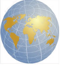
A. Answer the following in one word:
1. Name the place from where prime meridian passes-Greenwich
2. Name the end point of axis- Pole
3. The value of the equator is– 0°
4. Write total number of longitudes- 360
5. The three dimensional spherical model of the earth- globe
B. Answer the following in 5 to 10 words:-
1. What do mean by meridian?
Ans. Imaginary lines running from north to south are called meridian.
2. What is a grid?
Ans. Grid is a network of some imaginary horizontal and vertical lines around the earth.
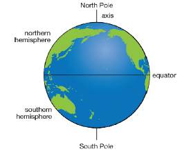
3. In which two hemispheres does the equator divide the Earth?
Ans. The two hemispheres in which the equator divides the Earth are:
a) The Northern hemisphere
b) The Southern Hemisphere
Q4. What is a parallel?
Ans. The parallels are the boundary lines of imaginary circles drawn around the earth
Q5. What is a globe?
Ans. A globe is a simple and accurate model of earth.
C. Answer the following in 20 to 25 words:
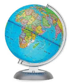
Q1. Explain types of globe?
Ans. The most common types of globe
a) Political globes show countrie
b) Physical globes shows landsca like mountains and rivers

D. Answer the following in 40 to 50 words:
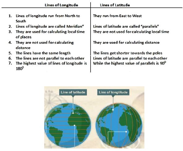
1. Write the differences between latitude and longitudes.
Ans. The differences between latitude and longitude are as follows:
2. How is globe useful to us?
Ans. Some uses of globe are:
1. It is used to locate place, see sea route, air route, etc.
2. Globes serve purposes similar to some maps
3. A globe is the only accurate way to study the whole Earth
4. It shows the distribution of land and water on the surface of the earth.
5. It shows the correct shape, size and location of the continents and oceans on globe.
I.Fill in the Blanks:
1. The earth is made up ____________ and ___________________.
2. Land covers about __________% and water about __________% of t5he earth`s surface.
3. The first person to invent the globe is ______________ .
4.Mountains join together are called as __________________.
5._________________ is a highland with a flat top.
6.Asia has the largest area covered by mountains - _______ percent.
7.The art of making maps is called __________
8.___________ was the first to publish a collection of maps in the form of a book.
9. ________________ is a huge mass of land which rises more than 900 metres above the mean sea level.
10.The word meridian comes from the Latin word ______________which means ___________.
II.Give meanings for the following:
1.A.M. - _____________________________________
2.P.M. - _____________________________________
3.Typhoon - __________________________________
4.Focus -_____________________________________
5.vent-_______________________________________
III.Answer the following:
1.What is Volcanic Mountain?
A:____________________________________________________________________
2.Name seven Continentsindecreasing order of size.
A:____________________________________________________________________
3.Name the four important parallels.
A:____________________________________________________________________
4.What are Longitudes?
A:____________________________________________________________________
5.How are mountains useful to us?
A:____________________________________________________________________
6.Write any three characteristics of a desert.
A:____________________________________________________________________
7.How are plains formed?
A:____________________________________________________________________
IV. Mark continents and oceans on the world political map:
Q1 Matching : - .
A B
i) Ferdinand Magellan i) a book of maps
ii) Gerardus Mercator ii) countries and capitals
iii) Highlands iii) a Portugese explorer
iv) Political maps iv) intermediate direction
v) Atlas v) ocean
vi) North-East vi) shades of brown
vii) Erdapfel vii) painted the map on the Erdapfel
viii) Georg Glockendon viii) a Flemish map-maker
ix) Antarctic ix) continent
x) South America x) Earliest surviving globes
Q2) Find directions :-
Students here we have to find directions using the Sun, Everyone knows that the Sun rises in the East, so stand facing the Sun in the morning i.e in the East direction . Now find the other directions-
a) _________ is to my left .
b) _________ is to my right .
c) _________ is to my back .
There are some intermediate directions also , and are as follows:-
i) _________ lies between the North and the East.
ii) _________ lies between the North and the West.
iii) _________ lies between the South and the East.
vi) _________ lies between the South and the West.
Answer :
Q1 Matching : - .
A B
i) Ferdinand Magellan i) a Portugese explorer
ii) Gerardus Mercator ii) a Flemish map-maker
iii) Highlands iii) shades of brown
iv) Political maps iv) countries and capitals
v) Atlas v) a book of maps
vi) North-East vi) intermediate direction
vii) Erdapfel vii) Earliest surviving globes
viii) Georg Glockendon viii) painted the map on the Erdapfel
ix) Antarctic i x) ocean
x) South America x) continent
Q2) Find directions :-
Students here we have to find directions using the Sun, Everyone knows that the Sun rises in the East, so stand facing the Sun in the morning i.e in the East direction . Now find the other directions-
a) North is to my left .
b) South is to my right .
c) West is to my back .
There are some intermediate directions also , and they are as follows:-
i) North East lies between the North and the East.
ii) North West lies between the North and the West.
iii) South East lies between the South and the East.
vi) South West lies between the South and the West.
I. Name the seven continents and five oceans.
Answer:
Continents:
1. Asia
2. Africa
3. North America
4. South America
5. Antarctica
6. Europe
7. Australia
Oceans:
1. Pacific Ocean
2. Atlantic Ocean
3. Indian Ocean
4. Southern Ocean (Antarctic Ocean)
5. Arctic Ocean
In simple words: The Earth has seven major landmasses called continents and five vast water bodies called oceans.
Exam Tip: Memorize the continents in order of size (largest to smallest) and remember that Australia is both a country and a continent.
II. Fill in the blanks
Question 1. An imaginary line that divides the earth into two equal halves is called ___________.
Answer: Equator
In simple words: The Equator is the zero-degree latitude line that splits the Earth into the Northern and Southern Hemispheres.
Exam Tip: Always capitalize Equator when referring to the primary line of latitude.
Question 2. The portion of the earth above the equator is called ___________.
Answer: Northern Hemisphere
In simple words: The half of the Earth that lies north of the Equator is the Northern Hemisphere.
Question 3. Lines of Longitude are also called as ___________.
Answer: Meridians
In simple words: Longitudes run from the North Pole to the South Pole and are known as meridians of longitude.
Exam Tip: Meridian comes from Latin roots meaning midday, as all points on the same meridian experience noon at the same time.
Question 4. There are ___________ number of latitudes drawn on the globe.
Answer: 181 (or 179 if excluding the poles)
In simple words: There are 90 latitudes in the Northern Hemisphere, 90 in the Southern Hemisphere, and the Equator itself, making 181 in total.
Exam Tip: Note that standard school textbooks generally accept 181 as the total number of latitude lines drawn at 1-degree intervals.
Question 5. The starting line to number the meridians is the ___________.
Answer: Prime Meridian
In simple words: The Prime Meridian, passing through Greenwich, London, is marked as \(0^\circ\) longitude and serves as the starting reference point.
Exam Tip: Do not confuse the Prime Meridian (\(0^\circ\) longitude) with the Equator (\(0^\circ\) latitude).
III. True or False.
Question 1. All the longitudes are of equal length. ( True )
Answer: True
In simple words: Unlike latitudes which get smaller toward the poles, all meridian lines stretch from pole to pole and are equal in length.
Exam Tip: Longitudes form complete semi-circles of equal size.
Question 2. Lines of latitude are also called as meridians. ( False )
Answer: False
In simple words: Lines of latitude are called parallels, while longitudes are called meridians.
Exam Tip: Read carefully - meridians are longitudes, parallels are latitudes.
Question 3. The north pole is marked as 90 S. ( False )
Answer: False
In simple words: The North Pole is located in the Northern Hemisphere and is marked as \(90^\circ\text{N}\).
Exam Tip: South Pole is \(90^\circ\text{S}\); North Pole is \(90^\circ\text{N}\).
Question 4. Equator is taken as the starting line to number the parallels. ( True )
Answer: True
In simple words: The Equator is designated as \(0^\circ\) latitude, from which all other parallel lines are numbered north and south.
Exam Tip: Equator is the reference baseline for latitude measurement.
Question 5. All Parallels are equal in length. ( False )
Answer: False
In simple words: Parallels decrease in length as you move away from the Equator toward the poles, where they become points.
Exam Tip: The Equator is the longest parallel circle.
IV. Give reason.
Question 1. The shape of the earth is like an orange.
Answer: The Earth is not a true sphere; it bulges slightly at the Equator and is slightly flattened at the North and South poles, which gives it a shape very similar to an orange (or an oblate spheroid).
In simple words: The Earth bulges in the middle and is flat at the top and bottom due to its rotation.
Exam Tip: Use the scientific term 'oblate spheroid' in your answer for full marks.
Question 2. The parallels are not equal in length.
Answer: Because the Earth curves inward and narrows as it extends from the wide equatorial region toward the northern and southern poles, the circles of latitude drawn around it become progressively smaller in circumference.
In simple words: Parallels near the poles circle a smaller diameter of the Earth than the Equator.
Exam Tip: Remember that latitude circles shrink from maximum length at the Equator to zero at the poles.
V. Choose the correct option.
Question 1. Total number of longitudes drawn on the globe
a) 180
b) 340
c) 360
Answer: (c) 360
In simple words: There are 360 degrees in a circle, so 360 longitude lines are drawn at 1-degree intervals around the globe.
Exam Tip: Longitudes measure complete circular degrees around the Earth's axis (\(360^\circ\)).
Question 2. The longest 0 latitude is
a) Equator
b) Prime meridian
c) north pole
Answer: (a) Equator
In simple words: The Equator is the \(0^\circ\) latitude line and represents the widest circumference of the Earth.
Question 3. At \(23\frac{1}{2}^\circ\text{S}\) lies the
a) Tropic of cancer
b) Arctic circle
c) Tropic of Capricorn
Answer: (c) Tropic of Capricorn
In simple words: The Tropic of Capricorn is located in the Southern Hemisphere at \(23\frac{1}{2}^\circ\text{S}\).
Exam Tip: Cancer is North (\(23\frac{1}{2}^\circ\text{N}\)), Capricorn is South (\(23\frac{1}{2}^\circ\text{S}\)).
Question 4. At \(66\frac{1}{2}^\circ\text{N}\) lies the
a) South pole
b) Arctic circle
c) Antarctic circle
Answer: (b) Arctic circle
In simple words: The Arctic Circle is situated in the Northern Hemisphere at \(66\frac{1}{2}^\circ\text{N}\).
Exam Tip: Arctic is North, Antarctic is South.
VI. Using the atlas, Find the latitudes and longitudes between which Saudi Arabia and India lies.
Answer:
| Country | Latitude | Longitude |
|---|---|---|
| Saudi Arabia | \(16^\circ\text{N}\) to \(32^\circ\text{N}\) | \(34^\circ\text{E}\) to \(55^\circ\text{E}\) |
| India | \(8^\circ 4'\text{N}\) to \(37^\circ 6'\text{N}\) | \(68^\circ 7'\text{E}\) to \(97^\circ 25'\text{E}\) |
In simple words: Atlas coordinates help pinpoint the exact geographical boundaries of countries on Earth.
Exam Tip: Always include direction letters (\(\text{N}, \text{S}, \text{E}, \text{W}\)) when writing geographic coordinates.
VII. Using the atlas, Name the states in India through which Tropic of Cancer passes.
Answer: The Tropic of Cancer (\(23\frac{1}{2}^\circ\text{N}\) latitude) passes through 8 states in India:
1. Gujarat
2. Rajasthan
3. Madhya Pradesh
4. Chhattisgarh
5. Jharkhand
6. West Bengal
7. Tripura
8. Mizoram
In simple words: An imaginary line divides India almost into two equal halves from west to east across these eight states.
Exam Tip: Remember the mnemonic or sequence from west to east (Gujarat to Mizoram) to easily recall all 8 states.
Free CBSE Practice Worksheets: Class 5 Social Science Globe A Model Of Earth
Daily Practice Questions for Class 5 Social Science
Explore reliable practice questions for Globe A Model Of Earth tailored for Class 5 Social Science learners. Use these structured worksheets to evaluate exam preparedness and strengthen problem-solving skills throughout the 2026 academic session.
Detailed Answers for Class 5 Social Science Globe A Model Of Earth
Each worksheet draws directly from authorized standard textbooks to maintain academic accuracy. Evaluating your finished exercises against expert-verified solutions helps master the formal presentation standards expected in school evaluations.
Complete Your Chapter Revision
Follow up your worksheet practice by attempting the interactive online MCQ tests for Globe A Model Of Earth to evaluate your execution speed. All printable assignments and revision sheets on our platform are updated for the 2026 session and available free of charge.
FAQs
You can download the latest chapter-wise printable worksheets for Class 5 Social Science Globe A Model Of Earth for free from StudiesToday.com. These have been made as per the latest CBSE curriculum for this academic year.
Yes, Class 5 Social Science worksheets for Globe A Model Of Earth focus on activity-based learning and also competency-style questions. This helps students to apply theoretical knowledge to practical scenarios.
Yes, we have provided solved worksheets for Class 5 Social Science Globe A Model Of Earth to help students verify their answers instantly.
Yes, our Class 5 Social Science test sheets are mobile-friendly PDFs and can be printed by teachers for classroom.
For Globe A Model Of Earth, regular practice with our worksheets will improve question-handling speed and help students understand all technical terms and diagrams.