

Voyage Solutions for Class 8 Geography: Chapter 01 Interpreting Topographical Maps
Access the official Voyage textbook solutions for Class 8 Geography, updated for the 2026-27 academic year. This digital resource is structured to help students build strong conceptual clarity and prepare effectively for school examinations.
Chapter-wise Solutions: Chapter 01 Interpreting Topographical Maps
View or download the dedicated Chapter 01 Interpreting Topographical Maps resource below. This chapter-by-chapter structuring ensures easy navigation for daily study routines and immediate access to core academic concepts.
A. Fill in the blanks
Question 1. Fill in the blanks:
(i) A contour line is an imaginary line that connects all points having the same _________ above sea level.
(ii) In a grid system of a topo sheet, the lines that run vertically are called _________.
(iii) Contour lines do not _________ one another.
(iv) The contour lines of a hill are evenly spaced in the form of _________ _________.
(v) Houses or huts in _________ settlement are far apart from one another.
Answer:
(i) height
(ii) eastings
(iii) intersect
(iv) concentric circles
(v) scattered
In simple words: Fill in the missing words to make the geographic statements correct.
Exam Tip: Always read the full statement carefully and look for key geological and topographical terms like 'eastings', 'intersect', and 'concentric' to fill in the blanks correctly.
B. Match the following columns
Question 2. Match the following columns:
| Column A | Column B |
|---|---|
| 1. 45D/7 | (a) To begin reading at topo sheet |
| 2. South-west corner | (b) Depression |
| 3. \( \Delta \)217 | (c) Gujarat |
| 4. White portion in a topo sheet | (e) Barren land |
| 5. DEP | (b) Depression |
Answer:
1. 45D/7 - (c) Gujarat
2. South-west corner - (a) To begin reading at topo sheet
3. \( \Delta \)217 - (d) Triangulated station
4. White portion in a topo sheet - (e) Barren land
5. DEP - (b) Depression
In simple words: This matching helps us connect different symbols and map markings with what they actually mean on a topographical sheet.
Exam Tip: Remember standard map symbols like DEP for depression and a triangle with a number for a triangulated station to secure full marks in matching questions.
C. Choose the correct answer
Question 1. The contour lines for this feature are evenly spaced in the form of concentric circles.
(a) conical hill
(b) plateau
(c) ridge
(d) saddle
Answer: (a) conical hill
In simple words: A symmetrical cone-shaped hill will have circular contours that are spaced out evenly.
Exam Tip: Remember that circular contour patterns always indicate a conical hill, while flat-topped structures indicate a plateau.
Question 2. The contours for this feature are oval with contours close to each other indicating steepness.
(a) conical hill
(b) plateau
(c) ridge
(d) saddle
Answer: (c) ridge
In simple words: A ridge is shown by long, oval contours that are very close to one another, showing its steep sides.
Exam Tip: Look for elongated, oval-shaped contour lines with close spacing to easily identify a ridge on a topo sheet.
Question 3. This feature can be identified by a drop in height of the contours.
(a) conical hill
(b) ridge
(c) col
(d) gap
Answer: (c) col
In simple words: A col is a low point between two high peaks, marked by a decrease in contour elevation.
Exam Tip: A drop in contour value between two summits is a classic indicator of a col or a saddle.
Question 4. The green area in a topo sheet contains
(a) settlement
(b) barren land
(c) cultivated land
(d) vegetation
Answer: (d) vegetation
In simple words: Green colour on any topographical map represents forested regions and areas covered with plants.
Exam Tip: Always associate green with natural vegetation, yellow with agricultural land, and white with barren ground on topographical sheets.
Question 5. On the topographical map these water bodies are shown in black colour.
(a) Dry Nadi
(b) Tank
(c) Settlement
(d) River
Answer: (a) Dry Nadi
In simple words: Water streams that have dried up and contain no water are colored black on topo sheets.
Exam Tip: Blue indicates perennial water bodies with water, while black represents dry streams and watercourses.
D. State whether the following are true or false
Question 1. A contour line is an imaginary line that connects all points having the same temperature.
Answer: False.
A contour line is a virtual line that links all locations sharing the identical elevation above sea level.
In simple words: Contours show equal heights, not equal temperatures. Lines showing equal temperatures are called isotherms.
Exam Tip: Remember the basic definition of a contour line - it is always about height or elevation above sea level.
Question 2. The lines that run vertically are called nothings.
Answer: False.
The vertical lines on a topographical map are referred to as eastings, not northings or other terms.
In simple words: The lines running up and down on a map are called eastings.
Exam Tip: Remember that vertical lines are eastings (their values increase eastward) and horizontal lines are northings.
Question 3. Contour lines are drawn at fixed intervals.
Answer: True.
The gap in height between consecutive contour lines on a map remains constant.
In simple words: The distance in height between any two nearby contour lines is always the same on a single map.
Exam Tip: This constant height difference is known as the Vertical Interval (V.I.).
Question 4. A gap is a low lying depression or a valley which cuts through a range of hills.
Answer: True.
A gap represents a low-lying passageway or river valley that dissects a chain of hills.
In simple words: A gap is a low area or path that goes right through a line of hills.
Exam Tip: Gaps are historically important as natural transport routes through mountain ranges.
Question 5. The spot height is indicated on the map with a small triangle followed by the number.
Answer: False.
A tiny triangle next to a number is used to represent a triangulated station, not a spot height.
In simple words: Spot heights are shown with a dot and a number. A triangle with a number shows a triangulated station.
Exam Tip: Be clear about the difference in symbols between spot heights (dot) and triangulated stations (triangle).
E. Answer the following questions in brief
Question 1. What do topographical maps show ?
Answer: Topographical sheets are detailed, large-scale maps depicting natural landforms like hills, rivers, mountains, and ridges, along with artificial details like buildings, roads, bridges, and railways.
In simple words: Topographical maps show both nature (like mountains and rivers) and things made by people (like roads and buildings) in great detail.
Exam Tip: Remember to mention both natural and man-made features to get full credit for this definition.
Question 2. What is a contour line ?
Answer: An imaginary line drawn on a map that links different locations having the same altitude relative to sea level is called a contour line.
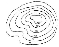
In simple words: A contour line connects all places on a map that are at the exact same height above the ocean.
Exam Tip: Use the phrase 'same height above sea level' or 'equal elevation' as these are the exact terms examiners look for.
Question 3. Distinguish Vertical Interval and Horizontal Equivalent.
Answer: The difference in altitude between two successive contour lines is called the Vertical Interval (V.I.), which remains constant for a specific map. In contrast, the ground distance separating two consecutive contour lines is the Horizontal Equivalent (H.E.), which is measured using the map's scale. The H.E. is smaller across steeper terrains and larger across flatter or gentler slopes.
In simple words: Vertical Interval is how much higher one line is than the next. Horizontal Equivalent is the actual physical distance between them on the ground.
Exam Tip: Remember that V.I. is always fixed on a map, while H.E. changes depending on how steep or gentle the slope is.
Question 4. What is a ridge ? How do you identify a ridge on a topo sheet ?
Answer: A ridge is an elongated, narrow highland feature with steep sides that rises above the surrounding flat terrain. It often functions as a water divide or watershed, directing streams down valleys on either side. It may also feature multiple summits of different heights. On topographical sheets, a ridge is identified by elongated, oval contour lines positioned closely together to reflect the steepness of its flanks.
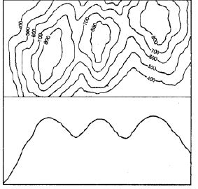
In simple words: A ridge is a long, narrow hill with steep sides. On a map, it is shown by long, oval contour lines grouped close together.
Exam Tip: Remember that a ridge is characterized by 'oval' contours and serves as a 'watershed' - these are critical keywords.
Question 5. What is a saddle ? Draw a diagram to show a saddle.
Answer: A saddle is a broad, shallow dip located at high altitudes between two mountain summits or ridges. This dip is typically carved out by glaciers or streams flowing in close proximity on opposite sides. It is not necessary for an active river or stream to run through a saddle.
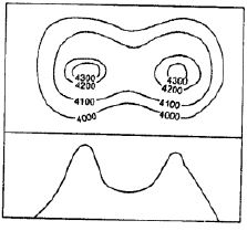
In simple words: A saddle is a low, flat dip between two high mountain peaks. It looks like a horse's saddle.
Exam Tip: Describe a saddle as a 'shallow depression at high elevation' and note that it connects two peaks without necessarily having water flowing through it.
Question 6. What is a linear settlement ? Where would you normally find a linear settlement ?
Answer: Linear settlements are communities that grow in a straight or continuous line. Houses, shops, eateries, fuel stations, and workshops are typically built along transport pathways like roads, railways, or river banks. Over time, these linear communities expand and turn into busy commercial hubs.
Examples:
1. When situated along a railway line, the growth of houses might eventually lead to the establishment of a railway station.
2. Along major highways, they emerge as essential rest stops for drivers, offering roadside cafes, tyre repair shops, and petrol stations.
3. Near rivers and shorelines, they develop in areas where vessels can dock to load and unload cargo and travelers.
In simple words: A linear settlement is a row of houses and shops built along a long road, river, or railway line.
Exam Tip: Clearly state that linear settlements develop along routes of transport (roads, railways, rivers) to get full marks.
Question 7. How would you recognize a metalled road and an un metalled one on a topographical map?
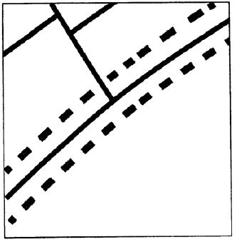
Answer: Metalled roads, which carry modern vehicles like trucks, cars, and buses, are shown on topographical maps as double red lines. On the other hand, unmetalled pathways include footpaths, pack tracks, and cart tracks, which are used to connect small rural villages and are usually represented by single or broken red lines.
In simple words: On a map, a metalled road is drawn as a double red line, while an unmetalled road (like a dirt path or cart track) is shown as a single or dashed red line.
Exam Tip: Remember that red color is used for roads on Indian topographical sheets, where solid double lines represent metalled roads and broken/single lines represent unmetalled tracks.
F. Answer the following questions in one or two paragraphs
Question 1. What is a cliff and how can we identify it on a toposheet ? Draw a diagram to show a cliff.
Answer: A cliff is a steep, near-vertical or completely vertical rock face. This landform shoots up directly from lower elevations. On a topographical sheet, a cliff is identified when contour lines run extremely close to each other, eventually merging or overlapping to form a single line.
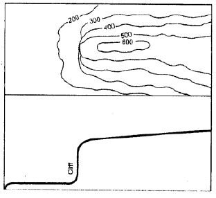
In simple words: A cliff is a very steep, vertical wall of rock. On a map, the lines are so close that they touch or run together.
Exam Tip: Remember that 'overlapping' or 'merging' contour lines are the definitive indicators of a cliff on a map.
Question 2. How is waterfall formed? Draw a diagram to show it.
Answer: A waterfall occurs when a river valley experiences a sudden, steep descent. Similar to a cliff, this drop-off is nearly vertical. Waterfalls typically form in the hilly, upper reaches of river paths. On a topographical map, they are identified by contour lines that lie extremely close together or merge as they intersect a river or stream.
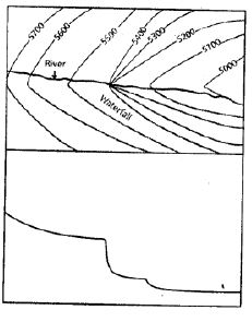
In simple words: A waterfall is made when a river suddenly drops down a steep, cliff-like edge. On a map, the lines will bunch up or touch right where the river crosses them.
Exam Tip: To identify a waterfall on a topo sheet, look for the intersection of a river line with closely spaced or overlapping contours.
Question 3. Where are V-shaped valleys and U-shaped valleys formed? How can these be identified on a topo sheet?
Answer:
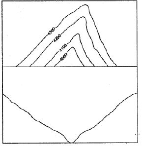
V-shaped Valleys: These are typically situated in the upper reaches of a river's flow, characterized by highly steep slopes on both sides. On a topographical sheet, they are easily spotted by contour lines that are closely spaced and form a clear 'V' shape pointing towards higher ground.
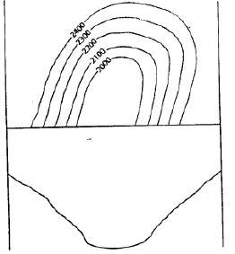
U-shaped Valleys: These valleys form in mountainous terrains where moving glaciers widen the valley floor into a flat 'U' shape. They can also appear in lower river courses where persistent lateral erosion widens the valley walls. On a map, these features are represented by contour lines that curve in a distinct 'U' shape.
In simple words: V-shaped valleys have sharp, steep sides made by fast-moving rivers. U-shaped valleys have wide, flat bottoms carved out by slow, heavy glaciers. On a map, their lines bend like a V or a U.
Exam Tip: For both features, emphasize the shaping agent (rivers for V-shaped, glaciers for U-shaped) and the specific bend of the contours (V-shape or U-shape).
Question 4. What are the different factors that determine the location and the type of settlements?
Answer: Many conditions influence where human habitations are established and how they develop:
1. Presence of flat, fertile land: People prefer to settle in plain areas where agriculture is possible, avoiding waterlogged swamps or rugged mountain slopes.
2. Availability of fresh water: Communities thrive near abundant water sources for household chores and farming, making riverbanks and river confluences highly popular settlement spots.
3. Plateau surfaces: Flat plateau regions with arable soil often attract populations because they offer stable terrain for cultivation.
4. Favorable climate: Moderate, pleasant weather conditions support population growth, whereas extreme climates that are excessively hot, freezing, wet, or arid discourage people from settling.
5. Job opportunities: Industrial sites and mining centers draw workers due to abundant employment options. These hubs usually develop close to natural resources and raw materials.
6. Accessibility and transport: Good connectivity via railway lines, roads, and waterways allows the convenient transportation of people and freight, making these areas highly desirable for living.
In simple words: People build homes where they can farm easily, find clean water, enjoy good weather, find jobs, and travel easily on roads or trains.
Exam Tip: Be sure to write at least four distinct factors (like water supply, flat land, transport, and climate) with brief explanations to secure full marks.
Question 5. How can transport and communication of an area be inferred directly from a topographical sheet?
Answer: On a topographical sheet, various colored lines represent different transit routes. For example, red or black lines indicate road networks and railway tracks, which show how well an area is connected. These symbols reveal the local transportation modes.
The density and convergence of these transit lines highlight the importance of specific locations. If multiple roads and railway networks meet at a town or village, it points to high economic activity, industrial growth, or tourism. Additionally, specialized signs, like an airplane icon, denote the location of airstrips or major airports, which are typically found near large urban centers.
In simple words: We can see roads and railways drawn as red or black lines on a map. When many lines meet at one spot, it means that town is very busy and important.
Exam Tip: Mention the significance of converging road/rail networks and specific symbols (like the aeroplane icon for airports) to demonstrate a thorough understanding of map interpretation.
G. Picture study
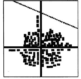
Question 1. Identify the type of settlement shown in the picture.
Answer: Nucleated or clustered settlement.
In simple words: It is a nucleated settlement, where houses are built very close together in a tight group.
Exam Tip: Recognise nucleated settlements by their clustered, dense layout where many houses are grouped closely around a central point.
Question 2. Write two characteristics of this type of settlement.
Answer:
1. Homes and other structures are grouped tightly in a compact, dense cluster.
2. These settlements are commonly found in fertile plain areas or river valleys that support intensive farming.
In simple words: The houses are packed tightly together, and they are usually built on flat, good farming land.
Exam Tip: For nucleated settlements, always highlight the close proximity of buildings and their typical location in flat, fertile regions.
Types of Settlements
1. Linear Settlements: These communities grow in a straight path. Structures like residences, shops, local eateries, fuel pumps, and car garages align alongside transport routes such as main highways, railway lines, or rivers. Over time, these linear groups grow and transform into trade points.
Examples:
(a) If a settlement borders a railway track, a new railway station might eventually be built there to serve the growing population.
(b) On major roads, these sites develop into popular transit stops for travelers, offering roadside diners, mechanic shops, and gas stations.
(c) Along rivers or shorelines, they serve as hubs where boats can dock to load and unload goods.
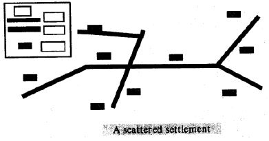
2. Scattered Settlements: Also referred to as dispersed settlements, these feature homes or cabins built far apart from one another. On a topo sheet, they are recognized by large distances separating the houses. These regions have very low populations and lack well-developed roads. Dwellings are generally linked by simple cart tracks or footpaths. Animal husbandry is widely practiced, with livestock grazing in expansive open pastures. The surrounding soil is usually too poor to sustain a large, dense population.
Let's Do Something
Question 1. Identify the relief features shown by the following contour diagrams:
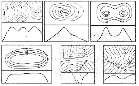
(a) Contour diagram (a)
(b) Contour diagram (b)
(c) Contour diagram (c)
(d) Contour diagram (d)
(e) Contour diagram (e)
(f) Contour diagram (f)
Answer:
(a) A Ridge
(b) A conical hill
(c) A Saddle
(d) A Plateau
(e) A Gap
(f) A Pass
In simple words: Match the contour line shapes with the physical landforms they represent, such as a ridge, conical hill, saddle, plateau, gap, or pass.
Exam Tip: Practice identifying these six basic relief diagrams, as recognizing them is a high-scoring question in map-reading exams.
Extra Questions
Question 1. What do you mean by eastings and northings in a topographical map ?
Answer: In the grid system of a topographical map, the vertical lines are referred to as eastings, which increase in value toward the east. Conversely, the horizontal grid lines are called northings, and their numeric values increase as one moves toward the north.
In simple words: Eastings are the vertical lines that go up and down on a map. Northings are the horizontal lines that go left to right.
Exam Tip: Remember that grid coordinates always state the easting value first and the northing value second.
Question 2. Mention features of a grid system of a topo sheet.
Answer: The major characteristics of a topographical map's grid system include:
1. Vertical grid lines are termed eastings, while horizontal grid lines are termed northings.
2. The intersections of these grid lines form squares known as grid squares.
3. The southwest corner (bottom-left) of the map serves as the origin or reference point.
4. Easting numbers grow larger as you go east from the southwest corner, and northing numbers grow larger as you go north.
5. Grid values are written as two-digit integers, meaning single digits like 0 are represented as 00 (e.g., 01, 02, 03).
6. In any grid reading, the easting coordinate is always read before the northing coordinate.
7. On standard maps with a 1:50,000 scale, grid lines are separated by 2 cm, which equates to a real-world distance of 1 km. Thus, a single 2 cm x 2 cm square on the map spans a 1 km x 1 km area on the ground.
8. Grid locations can be identified using either a four-figure reference or a six-figure reference system.
In simple words: The grid is a net of squares made by lines crossing. We use these lines to find any spot on a map by reading the vertical lines first and then the horizontal lines.
Exam Tip: Remember the rule 'Eastings first, Northings second' (commonly taught as 'along the corridor and up the stairs') to avoid making errors in grid references.
Question 3. Explain the two types of grid references.
Answer:
1. Four-Figure Grid Reference: This is employed to pinpoint a broad area or a whole grid square. For instance, the reference identifies a specific square by combining the two digits of the left easting with the two digits of the bottom northing (e.g., 1705).
2. Six-Figure Grid Reference: This is utilized to find tiny, specific structures - such as temples, wells, or post offices - with high precision. The first three digits correspond to the easting value, while the remaining three denote the northing value. To find this, the 1 km grid square is conceptually split into a 10x10 grid of smaller sections, giving the extra digits needed for high-accuracy readings (e.g., 213052).
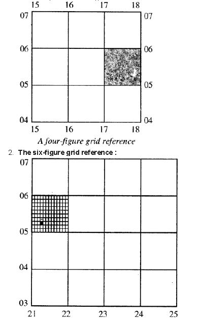
In simple words: A four-figure reference points to a large square on a map. A six-figure reference divides that square into smaller parts to locate an exact spot like a well or building.
Exam Tip: In a six-figure reference, the third digit (easting tenth) and the sixth digit (northing tenth) must be estimated accurately by mentally dividing the grid square into ten parts.
Question 4. Which is the most common method of showing relief or elevation on topo sheets ?
Answer: Using contour lines is the most widespread technique to depict landscape heights and shapes on maps.
In simple words: Contour lines are the most popular way to show the height of land on maps.
Exam Tip: Be ready to name 'contour lines' as the primary method used to represent topography and elevations.
Question 5. List some basic characteristics of contour lines.
Answer: Some fundamental properties of contour lines include:
1. They are mapped at uniform height increments (e.g., every 20 meters), which is known as the Vertical Interval (V.I.).
2. Contour lines never cross or intersect one another. Though they can merge or meet on vertical features, they do not overlap in a crossing manner.
3. On maps, every fifth contour line is highlighted or drawn with a bolder line, acting as a contour index.
4. The gap between successive contours displays the type of terrain slope: closely spaced lines denote steep slopes, widely spaced lines show gentle slopes, and evenly spaced contours show a uniform incline.
In simple words: Contour lines never cross, are spaced at equal heights, and their closeness shows how steep a hill is. Every fifth line is made extra thick to read easily.
Exam Tip: Memorize at least three properties of contour lines, particularly that they never cross and their spacing indicates slope steepness.
Question 6. How are topo sheets prepared for India ?
Answer: In India, topographical sheets are organized into three primary categories:
1. The Million Sheet: Drawn at a scale of 1:1,000,000 (1 cm representing 10 km), a set of 36 sheets covers the entire nation.
2. The Quarter-Inch Sheet: Produced at a scale of 1:250,000 (1 cm representing 2.5 km), with each sheet labeled individually from A through P.
3. The One-Inch Sheet: Utilizes a scale of 1:50,000 (2 cm representing 1 km).
In simple words: India's maps are made in three sizes: large ones covering huge areas, medium ones, and highly detailed local maps where 2 cm equals 1 km.
Exam Tip: Be sure to write down the exact scale values (1:50,000, 1:250,000, and 1:1,000,000) as these ratios are highly valued by examiners.
Question 7. How would you identify the following on a topo sheet:
1. Gentle slope and steep slope
2. Plateau
3. Hill
4. Col
5. Pass
6. Gap
Answer:
1. Gentle Slope and Steep Slope: Steep inclines are represented by closely packed contour lines, whereas gentle slopes are indicated by contours that are spaced far apart.
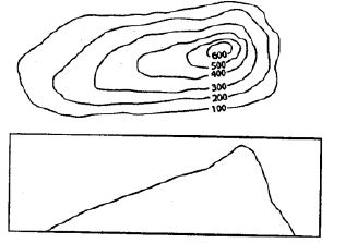
2. Plateau: Also known as tableland, a plateau is a raised, flat-topped feature with steep edges. On a map, it shows contour lines clustered tightly along its margins, with few or no contours in the broad, flat center.
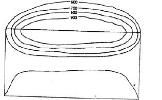
3. Hill: A hill has less height than a mountain and features regular steepness. Its contours appear as evenly spaced, nested concentric circles.
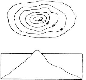
4. Col: This feature forms where a watershed is significantly eroded between two stream sources. It is identified on maps by a distinct dip in contour values.
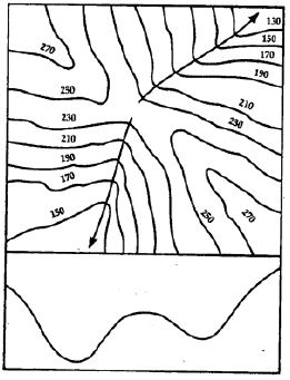
5. Pass: A pass is a low gap or path cutting between two mountain peaks in a range, marked by a drop in the elevation of contour lines.
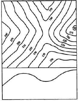
6. Gap: A gap is a low-lying valley or dip crossing a mountain range, which is frequently occupied by a river flowing through it.
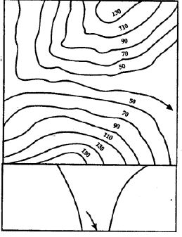
In simple words: We can identify slopes, hills, plateaus, cols, passes, and gaps on a map by studying the shape, closeness, and values of the contour lines.
Exam Tip: Be clear on the difference between a col, a pass, and a gap: cols are high erosional dips, passes are mountain paths, and gaps are wider depressions often containing rivers.
Question 8. What do you mean by settlements ? Explain temporary and permanent settlements.
Answer: Settlements are clusters of houses where people reside, such as towns or villages. Their size is influenced by key infrastructure like transport lines, clinics, police posts, and public offices. These communities expand gradually and can be categorized into temporary or permanent types.
Temporary Settlements: These are short-term dwellings built for brief habitation. They are typically set up by nomadic herders, hunters, gatherers, or slash-and-burn farmers, often using huts or tents. In cities, temporary camps might pop up near major construction sites (like bridges). Over time, some may develop into long-term residences.
Permanent Settlements: In these, people construct durable, long-lasting houses. Water accessibility and cultivable fields are key factors that prompt the growth of these permanent towns, which are further supported by facilities like schools, hospitals, roads, markets, and railways.
In simple words: A settlement is a place where people live. Temporary ones are built for a short stay (like tents), while permanent ones have strong, lasting houses (like villages and towns).
Exam Tip: Be sure to define 'settlement' first before distinguishing between temporary (short-term) and permanent (long-term) structures to maximize your score.
Question 9. What are the three main types of settlement patterns on a topo sheet ? Or Explain types of settlements.
Answer: The three primary settlement layouts visible on maps are:
1. Nucleated (or Clustered) Settlements: Houses and buildings are clustered closely together, commonly on flat, fertile lands or river valleys. These areas support farming and feature active communities with facilities like hospitals, post offices, and schools.
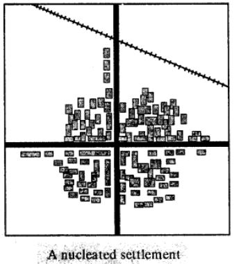
2. Linear Settlements: These develop in a single file or line along roads, railways, or river banks, starting with houses or shops and gradually expanding into business corridors.
3. Scattered (or Dispersed) Settlements: Homes are located far apart in regions with low population densities, poor soil quality, and rough terrain. Houses here are usually linked by simple cart tracks, with sheep or cattle rearing being the primary livelihood.
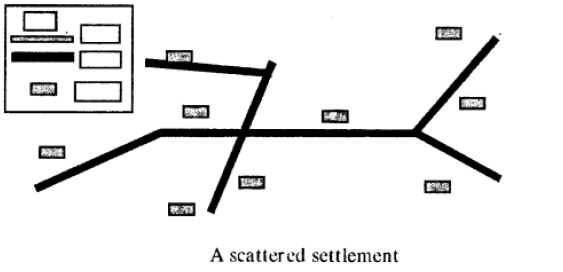
In simple words: The three main settlement patterns are clustered (houses grouped together), linear (houses in a line), and scattered (houses spread far apart).
Exam Tip: Memorize the three main patterns - nucleated, linear, and scattered - and how each is represented visually on a topo sheet (clustered red squares, aligned squares, or isolated squares).
Question 10. Compare Nucleated settlement and scattered settlement.
Answer:
Nucleated Settlements:
1. Homes are grouped together in tight, compact clusters.
2. They are found mostly on flat, fertile plains and river basins.
3. Often referred to as clustered settlements.
4. The soil is fertile and highly suited for farming.
5. They have closely-knit, large social communities.
6. Population density is high.
7. Basic amenities like schools, clinics, and offices are easily accessible.
8. Well-connected road and rail transport links exist.
Scattered Settlements:
1. Dwellings are spaced wide apart from one another.
2. They are typically located in mountainous, forested, or harsh-weather areas.
3. Often called dispersed settlements.
4. The land is barren or poorly suited for cultivation.
5. Communities are less cohesive with weaker social links.
6. Population density is very low.
7. Local services like hospitals and schools are scarce or absent.
8. Proper roads are lacking, with homes connected mainly by paths and tracks.
In simple words: Nucleated settlements are crowded towns on good farm land with great roads, while scattered settlements are spread-out houses on poor land in hills or forests.
Exam Tip: Frame your answer as a direct comparison list focusing on house density, terrain type, soil fertility, and available infrastructure to get full marks.
Question 11. List the aspects that you should keep in mind while studying a topographical map. Or Name some elements of a topo sheet or topographical maps.
Answer: Key components of a topographical map to study include:
1. Sheet ID: This displays the unique geographic identifier located at the top of the map.
2. Scale ratio: Explains the conversion factor (e.g., 1:50,000 where 2 cm represents 1 km) printed at the bottom edge.
3. Coordinate grid: Features intersecting red lines (eastings and northings) for locating positions.
4. Cardinal directions: The top represents North, the bottom is South, the right is East, and the left is West.
5. Grid values: Numeric labels on the axes that must be identified before reading coordinates.
6. Reference systems: Four-figure and six-figure grid readings.
7. Map legend: Provides keys to interpret standardized signs and symbols.
8. Vertical spacing: The contour interval (V.I.) representing the constant height difference between lines.
9. Spot elevations: Precise heights above sea level printed next to a dot.
10. Triangulated points: Accurately measured elevations shown next to a small triangle.
11. Accentuated contours: Bolder fifth lines (contour index) used for counting elevation.
12. Depressions (DEP): Indicates low-lying areas relative to surrounding ground.
13. Drainage lines: Black lines show dry beds, while blue lines denote active streams.
14. Contour shapes: Visual patterns like saddles, hills, ridges, passes, and gaps.
15. Color codes: Green shows forests/plants, yellow shows farms, and white shows uncultivated barren lands.
In simple words: Studying a map involves checking the sheet number, scale, grid lines, symbols, heights, water bodies, and colors.
Exam Tip: Be thoroughly familiar with the key color interpretations - green is vegetation, yellow is agriculture, and white is barren/unproductive land.
Question 12. What do you mean by Vertical Interval (V.I.) in a topo sheet ?
Answer: The constant altitude gap between any two successive contour lines on a map is known as the Vertical Interval (V.I.). This value remains uniform across a given map and is determined by the map's scale and the local landscape's elevation range. For instance, on maps scaled at 1:50,000, the V.I. is always set to 20 meters.
In simple words: Vertical Interval is the fixed step in height from one contour line to the next. For most standard maps, this step is exactly 20 meters.
Exam Tip: Always state that the V.I. remains constant for a particular topo sheet and quote the standard 20 m interval for 1:50,000 maps.
Question 13. Mention what do the following indicate on a topographical map -
1. Black stream
2. Blue stream
3. Green area
4. Yellow area
5. White area
Answer:
1. Black stream: Represents a dry stream bed that lacks water.
2. Blue stream: Denotes a perennial stream containing active water flow.
3. Green area: Signifies natural vegetation, particularly forests.
4. Yellow area: Identifies agricultural fields and cultivable grounds.
5. White area: Points to uncultivable, barren land where no agriculture occurs.
In simple words: Black streams are dry, blue streams have water, green areas are forests, yellow areas are farms, and white areas are empty barren land.
Exam Tip: Color coding is a favorite topic in exams. Make sure you can match black, blue, green, yellow, and white areas to their respective features immediately.
Question 14. Fill in the blanks:
(i) Eastings and northings cross each other to form a square known as a _________ _________.
(ii) When referring to a grid, _________ are always stated first.
(iii) Using _________ is the most common method of showing relief or elevation on topo sheets.
(iv) On a topographical map, every 5th line is drawn thick and known as the _________ _________.
(v) If contour lines are drawn close together, it indicates _________ slope of the land and if they are drawn far apart, it indicates _________ slope.
(vi) _________ are groups of houses where people live, such as villages or towns.
(vii) Tents and huts are the most common forms of shelter in _________ settlements.
(viii) _________ or _________ settlement indicates that the large community is close knit and living on a fertile land.
(ix) _________ settlement develop in a line on either side of a road or a railway track.
(x) _________ or _________ settlement is indicated by long distances between houses on map.
(xi) _________ _________ are indicated on the topo sheet with a small triangle followed by the number.
(xii) Settlements are always shown by _________ squares.
(xiii) The grid on the _________ corner of a topographical map is always the reference point or the starting point.
Answer:
(i) grid square
(ii) eastings
(iii) contours
(iv) contour index
(v) steep, gentle
(vi) Settlements
(vii) temporary
(viii) Nucleated, clustered
(ix) Linear
(x) scattered, dispersed
(xi) Triangulated stations
(xii) red
(xiii) south-west
In simple words: Fill in the correct topographical words to complete these sentences about maps.
Exam Tip: Reviewing these fill-in-the-blank statements is a great way to quickly revise key terminology like 'south-west corner', 'red squares', and 'contour index' right before the exam.
Free study material for Geography
ICSE Study Resources for Class 8 Geography Chapter 01 Interpreting Topographical Maps
About ICSE Solutions for Class 8 Geography Chapter 01 Interpreting Topographical Maps
Access structured ICSE solutions for Class 8 Geography Chapter 01 Interpreting Topographical Maps designed to match CISCE curriculum standards. These verified answers help clarify complex numericals and support daily homework revision.
Step-by-Step Explanations and Breakdown
Every exercise question in this chapter includes step-by-step working steps, allowing you to self-evaluate, catch mistakes early, and understand the underlying logic.
More Study Resources for Class 8 Geography
Wrap up your chapter revision by verifying core concepts against standard ICSE question formats. All resources on our platform are free to access.
FAQs
You can download the verified Voyage solutions for Chapter 01 Interpreting Topographical Maps on StudiesToday.com. Our teachers have prepared answers for Class 8 Geography as per 2026-27 ICSE academic session.
Yes, our solutions for Chapter 01 Interpreting Topographical Maps are designed as per new 2026 ICSE standards. 40% competency-based questions required for Class 8, are included to help students understand application-based logic behind every Geography answer.
Yes, every exercise in Chapter 01 Interpreting Topographical Maps from the Voyage textbook has been solved step-by-step. Class 8 students will learn Geography conceots before their ICSE exams.
Yes, follow structured format of these Voyage solutions for Chapter 01 Interpreting Topographical Maps to get full 20% internal assessment marks and use Class 8 Geography projects and viva preparation as per ICSE 2026 guidelines.