

Voyage Solutions for Class 9 Geography: Chapter 20 Natural Regions Of The World
Explore the complete Voyage textbook solutions for Class 9 Geography. Tailored for the 2026-27 curriculum, this resource breaks down complex topics to support daily study and targeted revision.
Chapter-wise Solutions: Chapter 20 Natural Regions Of The World
View or download the dedicated Chapter 20 Natural Regions Of The World resource below. This chapter-by-chapter structuring ensures easy navigation for daily study routines and immediate access to core academic concepts.
Exercises
I. Short Answer Questions
Question 1. Define the term ‘natural region’.
Answer: A natural region means an area on the surface of the Earth that shows a distinct consistency in its physical features and weather conditions.
In simple words: It is a geographic area where the land, weather, and plants are mostly the same throughout.
Exam Tip: Always define a natural region by emphasizing both physical characteristics and climatic consistency to secure full marks.
Question 2. Name any four natural regions of the world.
Answer: Four major geographic zones include the Equatorial belt, the Savanna (Tropical Grasslands), the Tropical Monsoon zone, and the arid Tropical Deserts.
In simple words: Four examples of natural regions are wet equator areas, hot grassy savannas, rainy monsoon areas, and dry deserts.
Exam Tip: Memorizing at least four distinct climate zones ensures you can easily answer basic categorization questions on natural regions.
Question 3. Briefly state the importance of climate.
Answer: Weather patterns play a crucial role in shaping human existence. Everyday habits, work choices, and commercial opportunities are closely linked to the local climate. Additionally, environmental conditions significantly influence how productively people can work.
In simple words: Climate determines how people live, what jobs they do, and how well they can work.
Exam Tip: Connect climate directly to human lifestyle and economic activities when discussing its global significance.
Question 4. State the location of the Equatorial Region.
Answer: This zone is situated across areas such as the Amazon basin, the Congo basin, and the Indonesian archipelago.
In simple words: The Equatorial region is located near the equator, mostly in places like the Amazon, Congo, and Indonesia.
Exam Tip: Always list key river basins and island countries when describing the geography of the equatorial belt.
Question 5. What is the latitudinal extent of the Monsoon climate?
Answer: The coordinates of this climatic zone span from 8°N to 23 1/2° N as well as from 8°S to 23 1/2° S.
In simple words: Monsoon climates are found between 8 degrees and 23.5 degrees latitude north and south of the equator.
Exam Tip: Be precise with degrees and hemisphere letters (N and S) to get maximum marks in geography coordinate questions.
Question 6. Name the two dominant type of vegetation of the Equatorial region.
Answer: The two primary plant types native to this area are ebony and rubber trees.
In simple words: Rubber and ebony are the main trees that grow in equatorial forests.
Exam Tip: Remembering specific tree varieties is highly useful for short questions on forest biomes.
Question 7. State the location of the Tropical Desert Climate type.
Answer: You can find these dry zones on the western edges of landmasses, situated from 15° to 30° latitudes in both hemispheres. In these zones, the offshore trade winds move from the interior land toward the ocean, which deprives the region of rainfall.
In simple words: Tropical deserts are found on the west coasts of continents. They are very dry because winds blow from the land to the sea, carrying no moisture.
Exam Tip: Mentioning 'western margins' and 'offshore trade winds' is essential to explain why these deserts exist.
Question 8. What are xerophytic plants ?
Answer: These are specialized plant species that lack typical leaves to minimize water loss from evaporation, relying instead on moisture stored inside their thick stems.
In simple words: These are desert plants that do not have leaves. They keep water inside their stems so they do not dry up.
Exam Tip: Highlight water storage and reduction of transpiration when defining desert flora.
Question 9. What local conditions produce variation in the Mediterranean Type of climate ?
Answer: This climate features dry summers and wet winters. Sitting in the path of the Westerlies, precipitation drops as you move inland from the coast. Regional weather is also shaped by cold, icy gusts like the 'Mistral' in France's Rhone valley and the 'Bora' in Greece. Conversely, scorching dry air streams like the 'Sirocco' in North Africa and the 'Khamsin' in Egypt raise temperatures and threaten agricultural yields.
In simple words: The Mediterranean climate has wet winters and dry summers. Local winds, like the cold Mistral or the hot Sirocco, change the weather and can hurt crops.
Exam Tip: Include names of local winds like Mistral, Bora, Sirocco, and Khamsin to write a high-scoring descriptive answer.
Question 10. State the rainfall pattern in the Mediterranean climate.
Answer: Precipitation in this zone falls primarily during the colder winter months, with yearly totals ranging between 35 cm and 75 cm. Rainfall is typically heavier in areas closer to the poles. This mild climate offers bright, sunny weather that acts as a major draw for global tourism.
In simple words: It rains mostly in winter, averaging 35 to 75 cm per year. The sunny, mild weather is perfect for tourists.
Exam Tip: Note the winter rainfall characteristic, as this is the defining unique feature of the Mediterranean climate.
Question 11. What type of vegetation is found in the Mediterranean region ?
Answer: The flora consists of specialized deciduous plants capable of surviving extended dry summers. The zone is globally famous for cultivating citrus orchards. Common tree species include olive, cork, oak, beech, ash, laurel, and oleander.
In simple words: The plants here can survive dry summers. This region is famous for growing citrus fruits like oranges and lemons, as well as olive trees.
Exam Tip: Remember to emphasize 'citrus fruits' and mention at least three tree types like olive, cork, and oak.
Question 12. Name six Temperate Grasslands of the world.
Answer: The six major mid-latitude grasslands are the Prairies of North America, the Pampas of South America, the Velds of South Africa, the Downs of Australia, the Steppes of Russia, and the Pustaz of Europe.
In simple words: Six temperate grasslands are the Prairies, Pampas, Velds, Downs, Steppes, and Pustaz, found across different continents.
Exam Tip: Always pair the name of each grassland with its corresponding country or continent for maximum clarity.
Question 13. Why there are no trees in the Steppe type climate region?
Answer: Annual precipitation in this zone is extremely low, averaging only around 20 cm. This moisture level cannot support tree growth, leading to the development of vast, smooth grassy plains instead.
In simple words: The area gets very little rain (about 20 cm), which is not enough for trees to grow, so only grass can survive.
Exam Tip: Cite the low rainfall figure (20 cm) to justify the absence of tall tree species.
Question 14. What is the temperature range in winter of the Cool Continental Climate Type ?
Answer: During winter, conditions regularly drop below freezing. The seasonal temperature fluctuation can exceed 50°C, with temperatures shifting from 1 to 2°C down to a frigid -50°C during the coldest periods.
In simple words: Winters are freezing cold. Temperatures can range from a chilly 1 or 2 degrees Celsius down to 50 degrees below zero.
Exam Tip: Clearly explain that 'temperature range' can be vast, dropping from near freezing to deep sub-zero values.
Question 15. Name the areas of the Cool Temperate Ocean type climate
Answer: This climate zone covers regions like the United Kingdom, northern Spain, France, Belgium, northern Germany, Denmark, British Columbia in Western Canada, the states of Washington and Oregon in the USA, Chile in South America, the Falkland Islands, Tasmania, and New Zealand.
In simple words: This climate is found in places like Great Britain, France, parts of western Canada and the US, Chile, and New Zealand.
Exam Tip: Provide a mix of Northern and Southern Hemisphere locations to show a complete geographical understanding.
Question 16. Give the annual rainfall of the above tropical region.
Answer: Precipitation in this climatic zone typically ranges between 50 cm and 120 cm each year.
In simple words: This region gets between 50 and 120 cm of rain every year.
Exam Tip: State the correct rainfall range clearly without confusing it with desert or equatorial ranges.
II. Give reasons for each of the following
Question 1. There is a uniformly high temperature in the Equatorial region.
Answer: Because the sun's rays strike this zone vertically throughout the year, the region receives intense, direct solar radiation, maintaining consistently warm temperatures.
In simple words: The equator gets direct sunlight all year round, so it stays hot all the time.
Exam Tip: Focus on the term 'vertical rays of the sun' or 'direct solar radiation' as the primary scientific cause.
Question 2. Deciduous trees shed their leaves in the dry season.
Answer: These trees drop their foliage during dry spells to conserve internal water, which would otherwise evaporate through leaf pores. Once the winter showers arrive, they begin to grow fresh foliage again.
In simple words: Trees drop their leaves when it is dry so they do not lose water. They grow new leaves once it rains.
Exam Tip: Explain 'transpiration' as the process the trees are trying to limit by dropping leaves.
Question 3. In the Tropical Desert climate region, Trade Winds are dry.
Answer: In these desert areas, the prevailing trade winds travel from the inner continent toward the ocean. Since they blow offshore, they cannot absorb moisture, resulting in very dry conditions and a lengthy hot season.
In simple words: The winds blow from the dry land toward the sea, so they do not have any water to make rain.
Exam Tip: Highlight that 'offshore' or 'land-to-sea' winds are the primary reason for lack of humidity.
Question 4. In the Mediterranean region of Europe, winds blow deep inside the land.
Answer: This zone lies within the pathway of the Westerlies, which travel with significant energy from the southwest to the northeast, penetrating far inland. When they meet icy polar air masses, they form fast-moving temperate cyclones that travel vast distances eastward, stretching from the Mediterranean all the way to China across central Asia.
In simple words: Strong winds called Westerlies blow far inland. They mix with cold polar air to create fast storms that travel all the way from Europe to China.
Exam Tip: Mention both the Westerlies and temperate cyclones to explain the far-reaching nature of these winds.
Question 5. Tropical grasslands have great potential for the cultivation of crops like cotton and coffee.
Answer: Consistently warm temperatures between 25°C and 30°C, combined with hot summers and moderate precipitation averaging around 100 cm, create the perfect agricultural environment for cash crops like coffee and cotton.
In simple words: These areas are hot and get plenty of rain (about 100 cm), which is exactly what crops like cotton and coffee need to grow.
Exam Tip: Incorporate specific temperature ranges (25-30 degrees C) and rainfall figures (100 cm) to validate your geographic reasoning.
Question 6. The Taiga region is sparsely populated.
Answer: The Taiga is blanketed by a vast expanse of coniferous forests where timber extraction and the fur trade are the primary economic activities. To protect these forest ecosystems, large-scale clearing for farming or housing is restricted, keeping human presence very low.
In simple words: The Taiga has huge pine forests used for logging and fur trapping. Because people want to keep the forests safe, they do not clear them for farms or towns, so few people live there.
Exam Tip: Connect sparse population to the dense coniferous tree cover and forest preservation for lumbering.
Question 7. There are no trees in the Tundra Region.
Answer: Permanent ice and sub-zero temperatures make tree growth impossible in this region. Only low-lying mosses, lichens, and tiny flowering plants sprout during the brief summer when temperatures peak at 10°C. Even with six months of daylight, the thick snow pack bounces solar energy back into space.
In simple words: The ground is frozen and covered in snow. It is too cold for trees to grow, and the snow reflects away the sun's warmth.
Exam Tip: Explain how 'albedo' (reflection of solar energy by snow) prevents heating, even during the long summer days.
Question 8. Patagonia is a desert in the rain shadow of the Andes.
Answer: Situated in South America, Patagonia is an arid, chilly desert created because the tall Andes mountains block rain-bearing winds. This blocks moisture from reaching the area, leaving most of this Argentinian region dry and cold.
In simple words: Patagonia is a cold desert in Argentina because the high Andes mountains block rain clouds from passing over them.
Exam Tip: Define the 'rain shadow effect' of the Andes as the reason for Patagonia's low rainfall.
III. Long Answer Questions
Question 1. Describe the general characteristics of natural regions. “Name four major natural regions in the world.
Answer: Each natural region features a distinct mix of physical landscapes and climate patterns that set it apart from other areas. Categorizing these zones helps humans understand how to adapt their lives and jobs to match the local environment. Four prominent natural regions of the globe are the Equatorial zone, the Savanna grasslands, the Tropical Monsoon region, and the dry Tropical Deserts.
In simple words: Every natural region has its own unique weather and geography. People adapt their jobs and homes to these regions. Four examples are the equatorial region, savannas, monsoon regions, and deserts.
Exam Tip: Explain that natural regions are classified based on climate and physical features, which directly affect human adaptation.
Question 2. State the factors of responsible for climatic classification of natural regions
Answer: Solar radiation decreases from the equator toward the poles, creating distinct seasonal variations at different latitudes. For instance, equatorial zones are consistently hot and humid, while monsoon regions experience distinct summers, rains, autumns, and winters. Tropical deserts remain hot and arid, whereas temperate grasslands face short summers and long winters. Mediterranean areas feature warm, dry summers and wet winters. Further poleward, the Taiga experiences prolonged winters and brief summers, while the Tundra is locked in permanent ice. Furthermore, because of the planet's axial tilt, the polar zones experience six-month periods of continuous day or night, keeping temperatures below -58°C.
In simple words: The sun's heat is strongest at the equator and weakest at the poles, creating different climates. The earth's tilt also causes polar regions to have six months of daylight and six months of darkness.
Exam Tip: Connect latitude, insolation, and axial tilt to explain the diversity of global climate zones.
Question 3. Give a brief account of Rainforests together with their location and types of trees.
Answer: Sustained high temperatures and heavy rainfall nurture dense tropical rainforests near the equator. In South America's Amazon basin, they are locally referred to as 'Selvas'. Other major habitats include the Congo (Zaire) basin, Malaysia, Indonesia, and the southern Philippine islands. Typical tree varieties found here include mahogany, ebony, rosewood, cinchona, and rubber.
In simple words: Tropical rainforests grow in hot, wet equatorial areas. They are called 'Selvas' in the Amazon. Famous trees here include rubber, mahogany, and ebony.
Exam Tip: Be sure to mention regional names like 'Selvas' and list multiple locations and tree types to secure full marks.
Question 4. Discuss the vegetation of the Tropical Monsoon type climate.
Answer: Characterized by a distinct wet season followed by dry autumns and winters, this zone primarily hosts deciduous plants that shed leaves. However, coastal strips get enough moisture to support evergreen rainforests with trees like rosewood, ebony, shisham, and bamboo reaching heights up to 60 meters. In drier areas, deciduous trees like khair and tendu are more common.
In simple words: Because monsoon regions have wet and dry seasons, most trees lose their leaves in the dry season. Coastal areas have tall evergreen trees, while drier parts have trees like khair.
Exam Tip: Distinguish between the deciduous inland vegetation and the evergreen coastal vegetation of monsoon regions.
Question 5. Bring out the chief characteristics of the Mediterranean type climate.
Answer: This climate is distinct for having damp winters and extended dry summers, with moderate annual rainfall capping at 75 cm. The pleasant, sun-drenched weather makes it perfect for outdoor movie production, which is why major hubs like Hollywood in California developed in this zone.
In simple words: This climate has sunny, dry summers and mild, rainy winters. The pleasant, clear weather is great for filming movies.
Exam Tip: Highlight the unique winter rainfall pattern and use Hollywood as a practical real-world example of human adaptation.
Question 6. Differentiate between Mediterranean type climate and China type climate.
Answer: Mediterranean climate:
(a) Situated on the western edges of continents.
(b) Features a wet subtropical winter alongside a prolonged summer drought.
(c) Yearly rainfall averages between 35 cm and 75 cm.
(d) Highly favorable for growing citrus fruits.
China type climate:
(a) Situated on the eastern edges of continents.
(b) Receives plenty of rainfall with a very brief dry spell.
(c) Yearly rainfall averages around 110 cm.
(d) Well-suited for a wide variety of grain crops.
In simple words: Mediterranean climates are on the west coast, have dry summers, and are great for citrus fruits. China-type climates are on the east coast, get more rain, and are great for growing crops.
Exam Tip: Use a structured side-by-side comparison comparing location (east vs west margins) and rainfall patterns to score full marks.
Question 7. Bring out the differences between the tropical and temperate deserts in terms of climate and vegetation.
Answer: Tropical Deserts:
(a) Located closer to the equator, between 15° and 30° latitudes in both hemispheres.
(b) The climate is extremely hot and dry.
(c) Vegetation includes cacti, palm trees, and various xerophytic plants.
(d) Summer temperatures can reach 30°C to 45°C, with winters staying above 20°C. They receive less than 25 cm of rain annually.
Temperate Deserts:
(a) Located further inland at higher latitudes, between 40° and 55° in both hemispheres.
(b) The climate is characterized by cold, dry conditions.
(c) Plant life consists of hardy shrubs, deep-rooted grasses, and stunted trees.
(d) Temperatures generally stay between 3°C and 12°C, dropping to -10°C in places like Calgary, with annual rainfall ranging from 20 cm to 60 cm.
In simple words: Tropical deserts are hot, close to the equator, and have cacti. Temperate deserts are cold, located further north or south, and have thorny bushes.
Exam Tip: Focus on latitude differences and temperature ranges to highlight the physical contrast between hot and cold deserts.
Question 8. Prepare the rainfall graph of the data given below and answer the questions that follow :
| Jan. | Feb. | Mar. | Apr. | May | June | July | Aug. | Sep. | Oct. | Nov. | Dec. | |
|---|---|---|---|---|---|---|---|---|---|---|---|---|
| Temp(°C) | 26.9 | 27.6 | 28.7 | 29.1 | 28.4 | 26.5 | 25.9 | 26.0 | 26.4 | 26.8 | 27.1 | 26.9 |
| Rainfall mm | 22.2 | 25.4 | 48.7 | 128.5 | 326.3 | 741.3 | 610.4 | 348.7 | 249.0 | 316.9 | 159.8 | 47.4 |
(a) What is the average annual temperature ?
(b) Calculate the annual range of temperature.
(c) In which climate type is this station ?
Answer:
(a) The mean yearly temperature is 27.2°C, calculated by summing all monthly values and dividing by twelve: \( (26.9 + 27.6 + 28.7 + 29.1 + 28.4 + 26.5 + 25.9 + 26.0 + 26.4 + 26.8 + 27.1 + 26.9) \div 12 = 326.3 \div 12 = 27.2 \).
(b) The yearly temperature range is 3.2°C, found by subtracting the minimum monthly value from the maximum monthly value: \( 29.1 - 25.9 = 3.2 \).
(c) This station is located in an Equatorial climate zone.
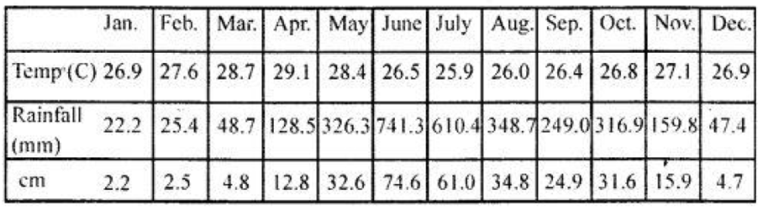
In simple words: The average temperature for the year is 27.2 degrees Celsius. The difference between the hottest and coldest months is only 3.2 degrees, which points to an equatorial climate.
Exam Tip: Show your calculations step-by-step for temperature range and average to prevent minor calculation errors from costing you marks.
Practice Questions (Solved)
Question 1. What do you understand by a ‘natural resource’ ?
Answer: These are essential elements and materials provided naturally by the environment that humans and other living things need to survive.
In simple words: Natural resources are gifts from nature, like water, air, and plants, that we need to live.
Exam Tip: Include plants and animals as part of the living organisms that rely on these natural gifts.
Question 2. How many kinds of natural resources are available ? Name them.
Answer: Natural resources are categorized into two main groups: renewable and non-renewable. Resources like wind, water, vegetation, and solar energy are renewable, whereas soils and minerals are considered non-renewable since they can be permanently depleted if overused.
In simple words: There are two kinds of resources: renewable (which do not run out, like sunlight) and non-renewable (which can run out if we use them too fast, like minerals).
Exam Tip: Provide specific examples for both renewable and non-renewable categories to make your answer complete.
Question 3. What are the various uses of wood ?
Answer: Timber serves as a vital resource, utilized for building structures, making furniture, and providing fuel for residential and industrial heating. It is also used to manufacture farming tools, sports equipment, paper products, and railway ties.
In simple words: Wood is used for making houses, furniture, tools, sports gear, paper, and also as fuel.
Exam Tip: List diverse uses of wood - ranging from construction and energy to manufacturing - to secure high marks.
Question 4. Why are coal and petroleum called fossil fuels ?
Answer: These energy sources are termed fossil fuels because they originate from ancient organic matter buried deep within the earth. Coal developed from carboniferous forests squashed under heavy sedimentary layers, while oil formed from prehistoric marine organisms trapped inside shale formations. Over millions of years, intense heat and tectonic pressure transformed these remains into combustible fuels.
In simple words: They are called fossil fuels because they are made from the remains of ancient plants and animals that were buried under rocks for millions of years.
Exam Tip: Emphasize geological time and organic origin (prehistoric plants and animals) under tectonic pressure.
Question 5. What are the benefits of non-conventional sources of energy?
Answer: These alternative energy options - such as solar, wind, geothermal, and wave power - are clean, limitless, and do not run out. While setting up the required infrastructure is expensive, they offer long-term financial and environmental benefits with minimal carbon footprint.
In simple words: These energy sources, like solar and wind power, never run out and do not pollute the air, making them great for the long run.
Exam Tip: Highlight two main benefits: they are infinite (renewable) and environmentally friendly (pollution-free).
Question 6. What is the difference between sea water and fresh water?
Answer: Ocean water contains dissolved salts, averaging a salinity of 3.5% (or 35 parts per thousand), making it undrinkable. Conversely, fresh water is free of salinity, making it essential for drinking, domestic chores, and industrial operations.
In simple words: Sea water is salty and cannot be drunk, while fresh water has no salt and is safe for drinking and farming.
Exam Tip: State the exact salinity level of sea water (3.5% or 35 parts per thousand) to show precise knowledge.
Question 7. What is the total percentage of fresh water on the earth?
Answer: While oceans cover roughly 97% of the planet's total water, only about 3% is fresh water. Out of this small fresh supply, 2% is locked away in glaciers and ice sheets, leaving just 1% available in surface bodies like lakes, streams, and ponds.
In simple words: Only 3% of Earth's water is fresh. Most of that is frozen in ice, so only 1% is available in rivers and lakes.
Exam Tip: Remember the 97-3 ratio of salt to fresh water, and the breakdown of where fresh water is stored.
Question 8. What is hydro logical cycle ?
Answer: This continuous movement of water begins when heat evaporates ocean water into the atmosphere, where it cools and condenses to form clouds and mist. Once saturated, this moisture falls back to the ground as rain or snow, replenishing terrestrial water sources before flowing back to the sea. This cycle is essential for life, supplying fresh water for farming and daily activities.
In simple words: It is the water cycle: water evaporates from the ocean, turns into clouds, rains down on land, and flows back to the ocean.
Exam Tip: Describe the key stages: evaporation, condensation, precipitation, and run-off.
Question 9. What gases does air contain ?
Answer: The atmosphere consists primarily of nitrogen and oxygen, with smaller quantities of carbon dioxide and argon present as well.
In simple words: Air is made up mostly of nitrogen and oxygen, along with some carbon dioxide and argon.
Exam Tip: Ensure you list nitrogen and oxygen as the dominant gases when describing atmospheric composition.
Question 10. Name the gases that are found in air along with their percentage.
Answer: The air is composed of 78% nitrogen, 21% oxygen, 0.9% argon, and 0.1% other trace gases.
In simple words: The air we breathe is 78% nitrogen, 21% oxygen, and 1% other small gases.
Exam Tip: The exact percentages of nitrogen (78%) and oxygen (21%) must be memorized for exams.
Question 11. Why is oxygen essential ?
Answer: This gas is vital because it enables respiration, supporting the survival of living organisms across the planet.
In simple words: Oxygen is necessary because humans and animals need it to breathe and stay alive.
Exam Tip: Use the scientific term 'respiration' when explaining why oxygen is vital.
Question 12. How is carbon dioxide useful ?
Answer: Plants utilize atmospheric carbon dioxide during photosynthesis to manufacture nutrients and release oxygen back into the environment.
In simple words: Plants use carbon dioxide to make their own food and produce the oxygen we breathe.
Exam Tip: Connect carbon dioxide use directly to the process of plant food production (photosynthesis).
Question 13. How does an air conditioner help ?
Answer: A cooling unit works by maintaining indoor warmth and humidity at pleasant levels, generally keeping temperatures between 20°C and 25°C and moisture between 35% and 70%.
In simple words: An air conditioner cools the room and removes extra moisture from the air to make it comfortable.
Exam Tip: Specify the typical comfortable ranges of temperature and relative humidity managed by air conditioning.
Question 14. name five resources which we get from the earth.
Answer: Five essential materials sourced from our planet include agricultural soil, mineral deposits, coal, crude oil, and diverse plant life.
In simple words: Five things we get from Earth are soil, minerals, coal, oil, and plants.
Exam Tip: Provide a mix of living (biotic) and non-living (abiotic) resources to show a broad understanding.
Question 15. What does subsoil contain ?
Answer: This layer consists of weathered rock fragments, essential mineral elements, and small amounts of organic humus.
In simple words: Subsoil contains bits of rock, minerals, and some decayed plant matter called humus.
Exam Tip: Differentiate subsoil from topsoil by noting its higher mineral and rock content with less organic matter.
Question 16. What are minerals ? List any four minerals.
Answer: These are naturally occurring inorganic compounds extracted from the earth's crust through excavation. Four examples are gold, iron ore, manganese, and coal.
In simple words: Minerals are natural, non-living substances dug up from the ground. Examples are gold, iron, manganese, and coal.
Exam Tip: Define minerals as 'inorganic substances' and associate them directly with the process of mining.
Question 17. What type of resources are minerals ?
Answer: Minerals belong to the category of non-renewable resources, meaning their geological reserves are finite and cannot replenish once extracted.
In simple words: Minerals are non-renewable resources. Once they are mined and used up, they are gone forever.
Exam Tip: Explain that non-renewable resources have a fixed supply that cannot be replaced in a human lifetime.
Question 18. How do forests retain water ?
Answer: Tree canopies and root systems absorb heavy rainfall, slowing down runoff and slowly releasing the water into local river basins.
In simple words: Forests act like giant sponges. They soak up rain water and let it trickle slowly into rivers.
Exam Tip: Highlight how roots and soil absorption prevent floods by regulating the flow of water.
Question 19. What is meant by deforestation ?
Answer: This term refers to the large-scale clearing of forested land to create space for crops, pasture livestock, or harvest lumber for international trade.
In simple words: Deforestation is when people cut down large areas of trees to make space for farms, cows, or to use the wood.
Exam Tip: List multiple drivers of deforestation, such as agriculture, ranching, and commercial logging.
Question 20. What happens when fossil fuels are burnt ?
Answer: Combustion of these energy sources releases harmful pollutants into the air, generating heat-trapping gases and contributing to the formation of acid precipitation.
In simple words: Burning fossil fuels pollutes the air, releases gases that warm the planet, and can cause acid rain.
Exam Tip: Specify air pollution, greenhouse gas emissions, and acid rain as direct consequences of burning fossil fuels.
Question 21. List the inexhaustible sources of energy.
Answer: These perpetual energy options include solar radiation, moving water (hydro), ocean tides, wind currents, and nuclear power.
In simple words: Inexhaustible energy sources are ones that never run out, such as sun, water, wind, tides, and nuclear energy.
Exam Tip: Remember that 'inexhaustible' is another term for renewable or virtually infinite energy resources.
Question 22. Which places in India can be used for tidal power generation ?
Answer: Ideal locations across the country include the Gulf of Khambhat, the Gulf of Kachchh, the deltaic Sundarbans, and various other coastal stretches.
In simple words: In India, places like the Gulf of Kutch, Gulf of Cambay, and the Sundarbans are perfect for making electricity from ocean tides.
Exam Tip: Name-drop the Gulf of Kutch and Gulf of Cambay specifically, as they are major Indian tidal energy zones.
Question 23. How many biogas plants have been set up in India under the National Biogas Development Programme ?
Answer: A total of 1.5 million (15 lakh) biogas facilities have been established throughout the nation under this initiative.
In simple words: India has built 15 lakh (1.5 million) biogas plants to help make clean cooking gas.
Exam Tip: Be sure to state the exact number (15 lakh) to score full marks for this direct factual question.
Question 24. What is geothermal energy ? Give examples of geothermal energy.
Answer: This form of power involves capturing thermal energy from deep inside our planet to warm indoor spaces and produce electric power. Key natural indicators include volcanic activity and hot geysers.
In simple words: Geothermal energy is heat that comes from deep inside the earth. We can see it in action in hot springs and volcanoes.
Exam Tip: Use 'earth's internal heat' as the core definition and list hot springs as a visible example.
Question 25. How is ground water formed ?
Answer: When precipitation falls as rain, it lands on the ground and gradually seeps down through the soil and porous rock layers, collecting deep underground as a subsurface reservoir.
In simple words: Rainwater falls on the ground and sinks deep into the soil to become underground water.
Exam Tip: Use the word 'percolation' or 'seeping' to explain how water transitions from surface rain to groundwater.
Question 26. List the advantages and disadvantages of solar energy.
Answer: This green energy can be captured using photovoltaic cells to produce electricity directly, or focused via mirrors to heat water and run steam turbines. It is incredibly useful for desalination and electrifying remote villages. However, drawbacks include its reliance on clear daytime weather, low generation capacity during cloudy periods, and its limited feasibility in countries that lack year-round direct sunlight.
In simple words: Solar energy is great because it is free, clean, and can power remote villages. But it does not work at night or on cloudy days.
Exam Tip: Organize your response with clear headings for 'Advantages' and 'Disadvantages' to make it easy to grade.
Question 27. What is hydrological cycle ?
Answer: Powered by solar radiation, water evaporates from oceans and transpires from vegetation into the air as moisture. As this rising vapor cools, it condenses to form rain clouds, eventually returning to the earth as rain or snow. This water is absorbed by the ground or drains back to the sea, repeating the loop endlessly.
In simple words: The sun warms up water, which rises into the sky, turns into clouds, rains back down, and flows back to the oceans.
Exam Tip: Mention solar radiation as the primary driver of this entire movement of water.
Question 28. What is the aim of dividing the world into natural regions?
Answer: The purpose of this geographical classification is to analyze differences in the physical environment and understand how they influence human activities, lifestyles, and cultures globally.
In simple words: We divide the world into regions to study how different climates and environments change the way people live.
Exam Tip: The core aim is always to study the relationship between physical environments and human life.
Question 29. What forms the basis of a general scheme of natural regions of the world ?
Answer: A region's latitudinal coordinates and overall geographical span serve as the primary framework for classifying global natural zones.
In simple words: A region's distance from the equator (its latitude) is the main way we classify different natural regions.
Exam Tip: Always highlight 'latitudinal location' as the fundamental basis for regional climate schemes.
Question 30. Mention the regions that cover the following :
(a) Tropical Regions
(b) Warm Temperate Regions
(c) Cool Temperate Regions
(d) Polar Regions.
Answer:
(a) Tropical zones include:
1. Equatorial rainforests
2. Savannas (tropical grasslands)
3. Arid tropical deserts
4. Tropical east margin areas.
(b) Warm temperate zones include:
1. Mediterranean zones
2. China-type climates
3. Continental interiors.
(c) Cool temperate zones include:
1. Marine west coast climates
2. Mid-latitude grasslands
3. East margin zones
4. Taiga (coniferous forests).
(d) Polar zones include:
1. Cold Tundra deserts
2. Permanent ice caps.
In simple words: This lists the different climate zones of the world, from the hot tropics near the equator to the freezing ice caps at the poles.
Exam Tip: Memorize at least two subdivisions for each temperature zone for classification questions.
Question 31. Where does the tropical region lie ?
Answer: This hot zone spans approximately between the 30° North and 30° South latitudes, flanking the equator.
In simple words: The tropical region is located between 30 degrees North and 30 degrees South of the equator.
Exam Tip: Remember the 30 degrees limit for both North and South hemispheres.
Question 32. Where does the warm temperate region lie ?
Answer: These zones are located between 30° and 45° latitudes in both the Northern and Southern hemispheres, situated just outside the tropics.
In simple words: This region lies between 30 and 45 degrees latitude on both sides of the equator.
Exam Tip: Recognize that the warm temperate zone is a transition belt between the hot tropics and the cool temperate latitudes.
Question 33. Where does the cool temperate region lie ?
Answer: This climate zone is situated approximately between the 45° and 65° latitudes in both hemispheres.
In simple words: The cool temperate region lies between 45 and 65 degrees latitude, both north and south.
Exam Tip: Specify the coordinates for both hemispheres to secure full marks.
Question 34. Where does the polar region lie ?
Answer: These cold zones extend past the 65° latitude lines, reaching up to the North and South Poles within the Arctic and Antarctic circles.
In simple words: The polar regions are at the very top and bottom of the Earth, past 65 degrees latitude.
Exam Tip: Mention the Arctic and Antarctic circles as the markers for the polar boundaries.
Question 35. Name the continents where the equatorial regions are situated.
Answer: This tropical zone stretches across three primary landmasses: South America, Africa, and Asia.
In simple words: The equatorial region is found in South America, Africa, and Asia.
Exam Tip: Make sure to list all three major continents where the equator passes through.
Question 36. Which parts of Asia and S. America included in equatorial forest region.
Answer: Asian Equatorial Areas:
* Malaysia and Indonesia
* Irian Jaya and Papua New Guinea
* The southern islands of the Philippines
South American Equatorial Areas:
* The vast Amazon basin
* Low-lying coastal lands located between the Guiana and Brazilian highlands
* The coastal strip of Colombia.
In simple words: In Asia, this includes Indonesia, Malaysia, and the southern Philippines. In South America, it covers the Amazon basin and parts of Colombia.
Exam Tip: Detail both regional basins and island groups when asked about specific continent partitions.
Question 37. Name the areas constituting the equatorial region in Africa.
Answer: In Africa, this climate covers:
1. The Congo River basin
2. The Gulf of Guinea coast
3. The southern regions of Nigeria and Ghana.
In simple words: In Africa, the equatorial region is found in the Congo basin, the Guinea coast, and southern parts of Nigeria and Ghana.
Exam Tip: The Congo Basin is the most vital African equatorial area to mention in your answers.
Question 38. What are the chief features of the climate of equatorial regions ?
Answer: The primary climate characteristics of this zone include:
1. High levels of direct solar radiation.
2. Consistently high humidity throughout the year.
3. Nearly identical lengths of day and night.
4. Minimal seasonal differences due to the constant angle of the sun.
5. High cloud cover and regular heavy rainfall that prevent extreme heat waves.
In simple words: It is hot and humid all year, days and nights are of equal length, and rain falls almost every day.
Exam Tip: Explain that the dense cloud cover acts as a shield, preventing the equatorial temperatures from rising to desert-like extremes.
Question 39. Mention the major trees found in equatorial forests.
Answer: The primary tree species in these dense jungles include mahogany, ebony, rosewood, cinchona, ivory wood, and dye wood.
In simple words: Important trees in these forests include mahogany, ebony, rosewood, and cinchona.
Exam Tip: List at least four major hardwood species to demonstrate comprehensive botanical knowledge of the rainforest.
Question 40. Name any four countries which have monsoon climate.
Answer: Four nations that experience this seasonal wind pattern are India, Bangladesh, Pakistan, and Myanmar.
In simple words: Four countries with a monsoon climate are India, Pakistan, Bangladesh, and Myanmar.
Exam Tip: South Asian countries are the classic examples of monsoon-driven climates.
Question 41. Mention the location of Tropical monsoon type regions.
Answer: This climatic zone is found between 5° and 30° latitudes in both the Northern and Southern hemispheres.
In simple words: Monsoon regions are located between 5 and 30 degrees latitude on both sides of the equator.
Exam Tip: State the latitudinal boundaries clearly, noting that they do not sit directly on the equator but slightly away from it.
Question 42. What is the range of temperature in monsoon region in the interior of the continent.
Answer: Deep inside continental areas, summer warmth averages between 35°C and 38°C, while winter temperatures range from 15°C to 18°C.
In simple words: In inland areas, summer temperatures are hot (35 to 38 degrees Celsius) and winter temperatures are cooler (15 to 18 degrees Celsius).
Exam Tip: Make sure to clearly differentiate the high continental summer temperatures from the milder winter values.
Question 43. Why is there complete reversal of pressure gradients over Asiatic landmass ?
Answer: This absolute shift in atmospheric pressure occurs due to the seasonal north-south movement of the sun, which leads to unequal heating of the vast Asian landmass compared to the neighboring oceans.
In simple words: The sun's position changes during the year, heating the land and the ocean differently, which reverses the wind direction.
Exam Tip: Tie the pressure reversal directly to 'differential heating' and the 'apparent migration of the sun'.
Question 44. Name any two states of India which receive winter rainfall.
Answer: The coastal regions of Tamil Nadu and Andhra Pradesh get significant rainfall during the winter, brought by the retreating northeast monsoons.
In simple words: Tamil Nadu and Andhra Pradesh get rain in the winter from the northeast monsoon.
Exam Tip: The northeast monsoon (or retreating monsoon) is the specific wind system responsible for this winter rain.
Question 45. What is the location of tropical desert ?
Answer: These dry expanses lie on the western margins of continents between 15° and 30° latitudes in both hemispheres, situated within the trade wind zone. They generally lie poleward of the savanna grasslands.
In simple words: Tropical deserts are found on the western coasts of continents between 15 and 30 degrees latitude, just beyond the tropical grasslands.
Exam Tip: Link their location to the western margins and the trade wind belt.
Question 46. Name the parts that Sahara desert covers.
Answer: The vast Sahara desert spans sections of several countries, including Algeria, Libya, Egypt (UAR), Sudan, Mali, Niger, and Chad.
In simple words: The Sahara covers parts of Algeria, Libya, Egypt, Sudan, Mali, Niger, and Chad.
Exam Tip: Name at least four North African nations to show where the Sahara extends.
Question 47. Where are the following deserts located ?
(a) Arabian desert
(b) Thar desert
(c) Kalahari desert
(d) Atacama desert
Answer:
(a) Arabian Desert: Situated east of the Red Sea.
(b) Thar Desert: Located in the northwestern part of the Indian subcontinent.
(c) Kalahari Desert: Located in the southern region of the African continent.
(d) Atacama Desert: Stretches along the Pacific coast of South America, to the west of the Andes mountain range.
In simple words: This lists where major deserts like the Arabian, Thar, Kalahari, and Atacama are found around the world.
Exam Tip: Describing the relative location (like 'east of Red Sea' or 'west of the Andes') helps verify geographical accuracy.
Question 48. Mention the two features of the climate of tropical desert.
Answer: The two main climate traits of these deserts are:
1. Consistently high temperatures with dry air.
2. Extreme aridity, making them the driest regions on Earth.
In simple words: Tropical deserts are extremely hot, dry, and get almost no rain.
Exam Tip: State 'aridity' (extreme dryness) as the primary characteristic of desert climates.
Question 49. State the vegetation of deserts.
Answer: Desert plant life is characterized by:
1. Thorny bushes, cacti, hardy herbs, and coarse grasses.
2. Vegetation that rarely looks lush or green.
3. Drought-resistant plant structures, known as xerophytes.
4. Stunted tree species like acacia.
5. Date palms thriving around water-rich oases.
In simple words: Desert plants are mostly thorny scrubs and cacti that can survive with very little water. Date palms grow near water spots called oases.
Exam Tip: Explain that xerophytes have special features like deep roots or thick skins to survive the heat.
Question 50. Why are the deserts sparsely populated ?
Answer: These dry areas have very few inhabitants due to the severe scarcity of fresh water and arable land for growing food.
In simple words: Deserts have very few people because it is hard to find food and water there.
Exam Tip: Relate sparse population directly to the lack of basic resources needed for human survival.
Question 51. Name the typical animal of desert region.
Answer: The camel is the classic animal of this biome, having evolved unique physiological traits to survive in harsh, waterless terrain.
In simple words: The camel is the most famous desert animal because its body is built to survive the hot, dry climate.
Exam Tip: Name the camel and explain that its physical adaptation is key to its survival.
Question 52. What is the location of Mediterranean region ?
Answer: This climate belt is found on the western edges of continents, situated between 30° and 45° latitudes in both hemispheres, acting as a transition zone between hot tropical deserts and cooler temperate regions.
In simple words: It is located on the west coast of continents between 30 and 45 degrees latitude, sitting between hot deserts and cooler northern areas.
Exam Tip: Note that the Mediterranean zone sits on the 'western margins' of landmasses.
Question 53. Mention the extent of Mediterranean type climate in the following :
(a) Asia
(b) Europe
(c) Africa
(d) America
(e) Australia
Answer: The geographical range of this climate spans:
(a) Asia: Includes Turkey, Syria, Israel, and Lebanon.
(b) Europe: Covers Spain, Portugal, southern France, Italy, and Greece.
(c) Africa: Includes northwest Algeria, Morocco, Tunisia, and the southern tip of South Africa.
(d) North America: Covers the western coast of the USA, particularly California.
(e) Australia: Includes southern and southwestern coastal regions, along with the North Island of New Zealand.
In simple words: The Mediterranean climate is found around the Mediterranean Sea (Spain, Italy, Turkey), parts of California, South Africa, and southern Australia.
Exam Tip: Ensure you can list at least one country or state for each continent experiencing this climate.
Question 54. What are the general characteristics of the climate of Mediterranean region ?
Answer: The main climate traits of this zone are:
1. Hot, dry summers paired with mild, wet winters.
2. Moderate levels of precipitation.
3. Low levels of humidity during the warm season.
4. Regular patterns of hot and cold regional winds.
In simple words: It has hot, dry summers, mild, rainy winters, low humidity, and local winds.
Exam Tip: The combination of dry summers and wet winters is the key hallmark of this climate zone.
Question 55. Name the winds prevailing during summers and winter in Mediterranean region.
Answer: During the summer, dry trade winds blow up to 45° N latitude in the Northern Hemisphere. In the winter, moist Westerlies blow onshore, bringing rain to the western coasts.
In simple words: In summer, the dry trade winds blow. In winter, the wet Westerlies blow from the sea, bringing rain.
Exam Tip: Associate trade winds with summer drought and Westerlies with winter rainfall.
Question 56. What are the characteristics of the Mediterranean climate which makes it suitable for orchard farming ? Which state of USA is famous for orchard farming ?
Answer: Mild, wet winters combined with warm, sunlit summers create the perfect environment for growing fruit trees. In the United States, the state of California is world-famous for this style of agriculture.
In simple words: The warm sun and mild winter rains are perfect for growing fruits. California is very famous for this.
Exam Tip: Explain that abundant sunshine even in winter is the secret behind successful fruit farming here.
Question 57. Which country is the world’s leading producer of grapes?
Answer: The nation of Italy leads global production in grape cultivation.
In simple words: Italy grows more grapes than any other country in the world.
Exam Tip: Italy's geographic conditions make it ideal for viticulture (grape growing).
Question 58. Why is the Mediterranean region popular for fruit processing industry ?
Answer: A continuous, abundant supply of fresh fruit provides raw materials for processing. This has led to a highly successful wine-making industry (viticulture) across the region.
In simple words: Since they grow so much fruit, they have plenty of ingredients to make juices and wines, which created a big fruit-processing industry.
Exam Tip: Connect the fruit-processing industry directly to the thriving local vineyards (viticulture).
Question 59. Why Mediterranean region cannot support large cattle populations ?
Answer: The seasonal weather patterns do not support lush pasture lands because rain falls in the cold season when plant growth is slow. The remaining grasses are too dry, coarse, and sparse to feed large herds of cattle.
In simple words: They do not have lush green grass because it rains mostly in winter. The grass that does grow is too dry and tough for large herds of cows.
Exam Tip: Point out that winter rainfall limits grass growth during the warm, active growing season.
Question 60. During which season Mediterranean region receives most of its rainfall.
Answer: This climatic zone experiences its heaviest precipitation during the winter months.
In simple words: It gets almost all of its rain during the winter.
Exam Tip: This is a direct factual question; simply stating 'winter season' is sufficient.
Question 61. Give the important evergreen coniferous trees of Mediterranean region.
Answer: The primary evergreen conifers native to this climate are:
1. Pine trees
2. Fir trees
3. Cedar trees
4. Cypress trees.
In simple words: The main evergreen trees here are pines, firs, cedars, and cypresses.
Exam Tip: List at least three of these conifers to show thorough knowledge.
Question 62. For what is California famous and why ?
Answer: California is globally renowned for fruit orchard farming. This success is due to its mild, frost-free winters, long growing seasons, fertile river soils, and extensive irrigation networks.
In simple words: California is famous for growing fruits because it has warm weather, good soil, no frost, and plenty of water from irrigation projects.
Exam Tip: Mention both climatic factors (frost-free season) and human factors (irrigation projects).
Question 63. Mention three special cultures of Mediterranean region.
Answer: Three distinctive agricultural practices of this region are:
1. Silk farming (Sericulture)
2. Fruit and vegetable gardening (Horticulture)
3. Grape cultivation (Viticulture).
In simple words: Three special types of farming here are silk farming, growing fruits, and growing grapes for wine.
Exam Tip: Define these terms (sericulture, horticulture, viticulture) briefly to make your answer stand out.
Question 64. What is Viticulture ? Why is it so popular in Europe ?
Answer: Viticulture refers to the commercial farming of grapes. It is immensely popular in Europe because grapes grow exceptionally well in this climate and are the essential ingredient for the continent's historic wine industry.
In simple words: Viticulture is the science of growing grapes. It is popular in Europe because the weather is perfect for grapes, which are used to make wine.
Exam Tip: Clearly define the term 'viticulture' as grape cultivation and link it to the wine industry.
Question 65. By what names are the grasslands known in following areas :
(a) In North America
(b) In South Africa
(c) In Hungary
(d) In Eurasia
(e) In Australia.
Answer: These mid-latitude grasslands are known by different local names:
(a) In North America: Prairies
(b) In South Africa: Velds
(c) In Hungary: Pusztas
(d) In Eurasia: Steppes
(e) In Australia: Downs.
In simple words: Depending on where you are in the world, temperate grasslands have different names like Prairies, Velds, Steppes, or Downs.
Exam Tip: This is a high-yield question; matching the grassland name to the continent is a common exam favorite.
Question 66. Give the extent of steppes.
Answer: The Eurasian Steppes stretch from the eastern borders of the Black Sea and Caspian Sea across to the Loess highlands of northwestern China, encompassing Russian Turkestan and the Manchurian plains.
In simple words: The Steppes stretch all the way from the Black Sea across Russia and Central Asia into China.
Exam Tip: Mention key physical markers like the Black Sea, Caspian Sea, and China to describe this vast expanse.
Question 67. What kind of climate does Steppe has ?
Answer: This region experiences a continental climate with highly contrasting temperatures. In the Northern Hemisphere, landmass size causes hot summers and freezing winters. However, in the Southern Hemisphere, the climate remains milder due to the tempering influence of the nearby oceans.
In simple words: It has a dry, continental climate. In the north, summers are very hot and winters are freezing. In the south, the ocean keeps the climate milder.
Exam Tip: Differentiate the northern continental extremes from the southern maritime-influenced milder conditions.
Question 68. What is the mean annual rainfall in Steppe region ?
Answer: The average yearly precipitation in these dry grasslands ranges between 25 cm and 75 cm.
In simple words: The Steppes get about 25 to 75 cm of rain every year.
Exam Tip: Keep the range (25-75 cm) in mind, as it explains why only grasses (and not forests) can thrive here.
Question 69. What is the extension of prairies ?
Answer: The North American Prairies stretch from the borders of the Great Lakes westward to the foothills of the Rocky Mountains, covering parts of both Canada and the USA.
In simple words: The prairies stretch from the Great Lakes to the Rocky Mountains in North America.
Exam Tip: The Rocky Mountains and Great Lakes are the two major geographical boundaries of the Prairies.
Question 70. What is the average temperature and rainfall in prairies?
Answer: The mean annual temperature in this region is 16°C, with average rainfall levels falling between 50 cm and 75 cm.
In simple words: The average temperature is 16 degrees Celsius, and it gets 50 to 75 cm of rain a year.
Exam Tip: The slightly higher rainfall compared to the Steppes supports taller grasses in the Prairies.
Question 71. Give the location of China type climate region.
Answer: This climate zone is situated along the eastern coasts of continents, lying between the 20° and 40° latitudes in both the Northern and Southern hemispheres.
In simple words: It is found on the east coast of continents, between 20 and 40 degrees latitude.
Exam Tip: Always compare this with the Mediterranean climate, which is found on the *western* margins at similar latitudes.
Question 72. By which currents are the coastal parts of China type of climate affected ?
Answer: The shorelines bordering this climate zone are heavily influenced by offshore warm ocean currents.
In simple words: The coastal areas are kept warm and humid by warm ocean currents.
Exam Tip: Warm currents bring moisture and higher temperatures to these eastern continental margins.
Question 73. What are typhoons ?
Answer: Typhoons are powerful tropical storms or rotating weather systems that develop over the South China Sea.
In simple words: Typhoons are strong, spinning storms that happen in the China Sea.
Exam Tip: Clearly identify typhoons as the regional name for tropical cyclones in East Asia.
Question 74. Give two characteristics of vegetation of China type climate.
Answer: Two main vegetation traits of this zone are:
1. Dense, lush evergreen woodlands growing in the wetter coastal regions.
2. Sparse deciduous forests and grassy plains in areas that receive less rain.
In simple words: Wet areas have thick evergreen forests, while drier areas have scattered deciduous trees and grass.
Exam Tip: Contrast the humid coastal evergreen forests with the drier inland deciduous woodlands.
Question 75. In which parts of Africa do tropical grasslands occur ?
Answer: On the African continent, these vast grasslands cover an extensive belt surrounding the wet equatorial region in both the Northern and Southern hemispheres.
In simple words: In Africa, tropical grasslands form a huge ring around the wet central rainforests.
Exam Tip: These grasslands are famously known as the Savanna, bordering the equatorial rainforest belt.
Question 76. What is known as ‘Parkland’ ?
Answer: Certain stretches of these tropical grasslands are termed 'Parklands' because they feature clusters of scattered trees, particularly along wet river beds and at the edges of the equatorial forests.
In simple words: Parkland is a grassy area with groups of trees, usually found near rivers or close to the rainforest.
Exam Tip: Explain that trees in parklands are not dense like forests but grow in scattered clumps.
Question 77. Why is the Taiga known as the Cold Pole of the Earth’?
Answer: This forest zone is called the Earth's cold pole because Verkhoyansk, which recorded a sub-zero temperature of -68°C, is located here in Eastern Siberia. Frigid, heavy air settles in this basin for weeks, making it one of the coldest inhabited places on the globe.
In simple words: It is called the Cold Pole because Verkhoyansk in Siberia is located here, where temperatures have dropped to a freezing -68 degrees Celsius.
Exam Tip: Mention Verkhoyansk and its extreme temperature of -68°C to explain this geographical title.
Question 78. Why is Polar Tundra region called the cold desert ?
Answer: This icy biome is termed a cold desert because its yearly precipitation is incredibly low, measuring under 25 cm.
In simple words: The Tundra is called a cold desert because it gets less than 25 cm of moisture a year, similar to hot deserts.
Exam Tip: The key defining factor of any desert - hot or cold - is receiving less than 25 cm of annual precipitation.
Give reasons for the following
Question 79. There is little seasonal variation in the climatic condition of equatorial region.
Answer: Because the sun's rays strike this region directly throughout the year, the area receives a constant amount of heat, resulting in very little temperature change between seasons.
In simple words: Since the sun shines straight down on the equator all year long, the weather stays hot and never really changes.
Exam Tip: Point to the steady, high angle of the sun's rays to explain the lack of distinct seasons.
Question 80. Equatorial regions support luxuriant vegetation.
Answer: These zones boast dense, rich plant growth because they enjoy constant warmth and heavy rainfall throughout the year, creating ideal growing conditions.
In simple words: Rainforests are thick and lush because they get endless warmth and tons of rain.
Exam Tip: Combine both high temperatures and high precipitation to explain the dense plant growth.
Question 81. Nights in the deserts are very cold.
Answer: Desert nights grow very cold because the lack of cloud cover allows soil heat to escape rapidly into space. Additionally, cold ocean currents nearby help cool the coastal air.
In simple words: Deserts have clear skies with no clouds, so all the day's heat escapes into space as soon as the sun goes down.
Exam Tip: Focus on 'clear skies' and the absence of greenhouse-like cloud cover as the main cause of rapid night-time cooling.
Question 82. Camel is called the ship of the desert.
Answer: The camel earned this title due to its incredible physical adaptations to desert life:
1. Wide, padded feet that let it walk easily on soft sand.
2. The ability to store water in its tissues for days.
3. A fatty hump that provides energy during long periods without food.
4. The ability to eat tough, thorny desert shrubs.
5. High strength for carrying heavy loads across long distances.
In simple words: Camels are built to survive the desert. They can go days without water, walk on hot sand without sinking, and carry heavy loads.
Exam Tip: List at least three specific physical traits (padded feet, water storage, fatty hump) to back up your answer.
Question 83. Mediterranean regions receive most of their precipitation in winter season.
Answer: During the winter months, the wind belt shifts, allowing moisture-rich Westerlies to blow onshore from the oceans, bringing rain to these western continental margins.
In simple words: In winter, wet winds called Westerlies blow from the ocean onto the land, bringing rain.
Exam Tip: Explain that the shift of wind belts in winter brings the Westerlies into play.
Question 84. Climate conditions in the Mediterranean region do not favour grasses.
Answer: Grasses do not grow well here because the rainfall occurs during the cold winter when plant growth naturally slows down, while summers are completely dry.
In simple words: It rains mostly in winter when it is too cold for grass to grow well, and the summers are too dry for grass to survive.
Exam Tip: Highlight the mismatch between the wet season (winter) and the active growing season (summer).
Question 85. Agriculture is the main occupation of the people in most parts of the Mediterranean lands.
Answer: Farming is the leading livelihood in this region due to favorable conditions: a long, frost-free growing period, abundant sunshine, warm summers, and highly fertile soils.
In simple words: Most people farm here because the weather is sunny and warm, there is no frost, and the soil is very fertile.
Exam Tip: Detail the natural advantages like the frost-free season and plentiful winter moisture.
Question 86. Grasslands are treeless.
Answer: These plains lack trees because of highly porous soils and limited summer rain. Rapid water evaporation and strong, dry winds also prevent saplings from growing into trees.
In simple words: There are no trees because the soil drains water too fast, there is very little rain, and strong winds dry out the land.
Exam Tip: Cite both soil characteristics (porous nature) and climatic factors (wind and evaporation) to explain the lack of trees.
Question 87. The Steppe climate of the southern hemisphere is never severe rather it is moderate.
Answer: The mid-latitude grasslands in the Southern Hemisphere enjoy a milder climate because they are located much closer to the ocean, which tempers the extreme temperatures.
In simple words: In the southern half of the world, these grasslands are close to the ocean, which keeps the weather from getting too hot or too cold.
Exam Tip: Explain how 'maritime influence' or proximity to oceans moderates temperatures in the Southern Hemisphere.
Question 88. The western margins of continents are extremely dry.
Answer: These coastal edges remain highly arid because the prevailing trade winds blow offshore, moving from the dry inland areas toward the sea and carrying no moisture.
In simple words: The west coasts are dry because the winds blow from the dry land out to the sea, so they cannot bring any rain.
Exam Tip: The core explanation is that 'offshore trade winds' carry dry continental air instead of moist ocean air.
Differentiate between the following
Question 89. Humid regions and Sub-humid regions.
Answer: Humid Regions:
1. These areas receive more rainfall than water lost through evaporation all year round.
2. They do not face water shortages, even during dry spells.
Sub-Humid Regions:
1. Rainfall exceeds evaporation only during a short, specific wet season.
2. They experience significant water shortages during the dry parts of the year.
In simple words: Humid regions have plenty of water all year long. Sub-humid regions only have extra water during a short rainy season and face dry spells later.
Exam Tip: Compare how both regions handle water availability during their respective dry seasons.
Question 90. Humid regions and Arid regions.
Answer: Humid Regions:
1. Yearly rainfall is consistently higher than evaporation rates.
2. They enjoy a constant abundance of fresh water.
Arid Regions:
1. Precipitation is extremely low, falling far below evaporation rates throughout the year.
2. They suffer from severe, permanent water scarcity.
In simple words: Humid regions get plenty of rain and never run out of water, while arid regions are extremely dry and face water shortages all year.
Exam Tip: Describe arid regions as having a permanent deficit where evaporation exceeds precipitation.
Question 91. Warm temperate region and Cool temperate region.
Answer: Warm Temperate Region:
1. Spans from 30° to 45° latitudes in both hemispheres.
2. Includes Mediterranean climates, warm monsoon zones, and tropical deserts.
Cool Temperate Region:
1. Spans from 45° to 65° latitudes in both hemispheres.
2. Includes marine west coast zones, mid-latitude grasslands, and coniferous Taiga forests.
In simple words: Warm temperate regions are closer to the equator (30 to 45 degrees) and include Mediterranean climates. Cool temperate regions are further north/south (45 to 65 degrees) and include grasslands and pine forests.
Exam Tip: Differentiate these zones based on their latitudinal ranges and the specific climates found within each.
Question 92. Sericulture and Viticulture.
Answer: Sericulture:
1. This refers to the breeding and raising of silkworms.
2. It is practiced to produce raw silk, with major centers in northern Italy and southern France.
Viticulture:
1. This refers to the large-scale cultivation of grapevines.
2. It is done primarily for wine production, with leading hubs in Italy, France, Spain, and Portugal.
In simple words: Sericulture is raising silkworms to make silk. Viticulture is growing grapes to make wine.
Exam Tip: Identify silk as the product of sericulture and grapes/wine as the products of viticulture.
Question 93. Truck farming and orchard farming.
Answer: Truck Farming:
1. Also known as market gardening, this involves growing fresh fruits and vegetables to be shipped daily to local markets by truck.
2. Local climate is not the most critical factor, as it relies on transport access.
Orchard Farming:
1. This involves the large-scale growing of fruit-bearing trees, a signature practice in Mediterranean lands.
2. Success is highly dependent on specific climatic conditions, requiring intensive, year-round care.
In simple words: Truck farming is growing vegetables to sell in nearby cities daily. Orchard farming is growing fruit trees on a large scale, which requires specific warm weather.
Exam Tip: Highlight that truck farming focuses on fast market delivery, while orchard farming relies heavily on specific climates.
Question 94. Evergreen and Xerophytic trees of Mediterranean region.
Answer: Evergreen Trees:
1. These trees do not shed all their leaves at once, keeping their green foliage year-round.
2. They typically have narrow, needle-shaped leaves.
3. Classic examples in this region include pine, fir, cedar, and cypress trees.
Xerophytic Trees:
1. These plants are specially adapted to survive dry, hot summer droughts.
2. They feature small, thick, waxy leaves, protective thorns, and long taproots to find deep water.
3. Key examples include grapevines, laurel, and cork oak with its thick bark.
In simple words: Evergreen trees stay green all year and have needle-like leaves. Xerophytic trees have thick leaves, deep roots, or thorns to survive dry summers.
Exam Tip: Provide specific examples for both (like pine for evergreen and cork oak for xerophytes) to make your difference clear.
Question 95. Role of trade winds and westerlies in Mediterranean region.
Answer: Role of Trade Winds:
1. These winds blow during the dry summer months.
2. They extend up to approximately 45° latitude.
3. Because they blow offshore from dry continental interiors, they bring no rain, causing summer droughts.
Role of Westerlies:
1. These winds are dominant during the winter season.
2. They blow around the 30° to 40° latitude belt.
3. Blowing onshore from the oceans, they carry heavy moisture and bring much-needed winter rainfall.
In simple words: In summer, dry trade winds blow from the land, bringing hot, dry weather. In winter, wet Westerlies blow from the ocean, bringing rain.
Exam Tip: Describe trade winds as offshore (dry) and Westerlies as onshore (moist) to explain the seasonal rainfall.
Question 96. Steppes and Prairies.
Answer: Steppes:
1. The grasslands in Eurasia are known as Steppes.
2. The Steppes of Eurasia occur on either side of the Ural mountains covering the parts of Eastern Europe and Western Siberia in Asia.
Prairies:
1. The grasslands in North America are known as Prairies.
2. Prairies of North America lie between the Rockies and the Great Lakes of North America.
In simple words: Steppes are the grasslands of Russia and Europe, while Prairies are the grasslands of North America.
Exam Tip: State the specific geographic barriers (Ural Mountains for Steppes, Rockies for Prairies) to locate them precisely.
Question 97. Define Mangrove forest.
Answer: These are specialized forest ecosystems that grow in muddy coastal shores and salty, brackish swamps, hosting a wide variety of salt-tolerant plant species.
In simple words: Mangroves are forests of tough trees that grow in salty coastal waters and swamps.
Exam Tip: Use the terms 'brackish swamps' and 'coastal areas' when defining mangrove habitats.
Question 98. Define Shifting cultivation
Answer: This is a traditional, migratory farming method where farmers clear a small patch of forest, burn the cut vegetation to fertilize the soil, and plant crops among the stumps using simple tools.
In simple words: It is a farming method where people clear a patch of forest, burn the wood to fertilize the soil, grow crops, and then move to a new spot when the soil wears out.
Exam Tip: Also known as slash-and-burn agriculture, highlight its migratory nature.
Question 99. Define Oases
Answer: These are fertile, green spots in the middle of a dry desert where underground water rises to the surface, supporting plant and human life.
In simple words: An oasis is a green area in a desert where there is water, allowing plants and trees to grow.
Exam Tip: Mention that oases are formed where subterranean water pools reach the desert floor.
Question 100. Define Sericulture
Answer: This is the commercial practice of breeding and raising silkworms to harvest raw silk, with major production centers in France, Italy, and Spain.
In simple words: Sericulture is the farming of silkworms to produce beautiful silk thread.
Exam Tip: State that the primary goal of sericulture is the harvesting of high-quality raw silk.
Long Answer Questions
Question 101. (a) Give a brief account of climate of the Equatorial region. (b) Explain briefly the importance of Equatorial forests. (c) Why are Equatorial forests not commercially important?
Answer: (a) Climate of the Equatorial Region:
1. This zone experiences high, uniform temperatures (between 25°C and 30°C) and heavy rainfall throughout the year, with an annual temperature range of only about 2°C.
2. This steady warmth is due to the sun's rays striking the equator at a high angle (between 66.5° and 90°) all year.
3. Rain falls almost daily, ranging from 150 cm to over 350 cm, and is mostly of convectional origin due to daily solar heating.
4. The high humidity combined with clouds makes the climate warm but bearable.
(b) Importance of Equatorial Forests:
1. They act as the 'Lungs of the World' by absorbing massive amounts of carbon dioxide and releasing fresh oxygen.
2. They maintain global ecological balance, protecting the atmosphere and the ozone layer.
3. They are a rich source of life-saving medicines, such as quinine extracted from the bark of cinchona trees.
4. They provide valuable, dense hardwoods like mahogany, ebony, and rosewood.
(c) Why They Lack Commercial Value:
1. These forests are extremely dense and contain a highly mixed variety of trees, making it hard to harvest a single species.
2. Valuable wood species are scattered far apart over large areas, rather than growing in pure stands.
3. The muddy, swampy ground makes building roads or railways for transport nearly impossible.
4. The hot, humid, and disease-prone climate makes heavy labor difficult and oppressive.
In simple words: Equatorial regions are hot and wet all year, growing thick forests that produce oxygen and medicine. However, they are hard to log commercially because the ground is swampy, the trees are highly mixed, and the weather is too hot for workers.
Exam Tip: Break this answer down into parts (a), (b), and (c) as asked, using bullet points to make each section clear and easy to read.
Question 102. Explain the monsoon climate type region under the following heads : (a) Temperature (b) Air pressure and winds (c) Vegetation (d) Three seasons of Indian subcontinent.
Answer: (a) Temperature:
When the sun shines directly over the Tropic of Cancer in summer, the Northern Hemisphere heats up intensely. Temperatures reach 27°C to 30°C along coasts and shoot up to 35°C to 38°C inland. In winter, as the sun moves over the Tropic of Capricorn, temperatures drop to 22°C-25°C near the sea and 15°C-18°C inland. In May and June, parts of northern India experience scorching local winds called the 'loo'.
(b) Air Pressure and Winds:
1. Intense summer heat creates a strong low-pressure zone over the land, which draws in wet winds from the Indian Ocean.
2. The southeast trade winds cross the equator and are pulled into India as the wet southwest monsoon.
3. These regions experience a seasonal shift between high and low-pressure systems during winter and summer.
4. This causes a complete reversal of wind directions over the Asian continent.
(c) Vegetation:
The trees are mostly deciduous, shedding their leaves during the dry months to save water. Important tree species include teak, sal, bamboo, mahua, jamun, neem, and shisham. Wet coastal zones support tall evergreen rainforests, while delta areas host mangrove forests like the Sundarbans of the Ganges-Brahmaputra delta.
(d) Three Seasons of the Indian Subcontinent:
1. Hot, Dry Season (March to mid-June): High temperatures, low humidity, and common dust storms in the north as the sun moves northwards.
2. Hot, Wet Season (July to October): The main rainy season with heavy downpours that help cool the air.
3. Cold, Dry Season (November to February): Dominated by dry northeast monsoon winds, though they pick up some water over the Bay of Bengal to bring rain to the southeastern coast.
In simple words: The monsoon climate has hot summers and cooler winters. Winds reverse direction seasonally, bringing heavy summer rains. The forests are mostly deciduous, and the region experiences three main seasons: hot-dry, hot-wet, and cold-dry.
Exam Tip: When discussing monsoon seasons, explicitly mention wind reversals and the specific months for each season.
Question 103. (a) Elaborate the special features of vegetation in hot desert region. (b) What is the mode of rainfall in hot desert region.
Answer: (a) Special Features of Desert Vegetation:
1. The plants are highly adapted to survive with very little water and are known as xerophytes. They include thorny scrub, cacti, and prickly pears.
2. Many species have thick, waxy skins or are leafless to prevent water loss, and some have a bitter smell so animals will not eat them.
3. Cacti are the most common plants, with the Saguaro Cactus of the Arizona Desert being a famous example.
4. Date palms grow near wet oases where roots can reach underground water.
(b) Mode of Rainfall in Hot Deserts:
Hot deserts receive very little rainfall, averaging less than 25 cm a year. Because they are located on the western margins of continents, the trade winds blowing over them are offshore and dry, having already dropped their moisture over the eastern coasts. As these winds blow from cooler high latitudes to warmer low latitudes, they warm up and hold more moisture instead of releasing it. When rain does fall, it usually comes as sudden, torrential cloudbursts during violent convective thunderstorms.
In simple words: Desert plants are xerophytes like cacti that store water and have thorns instead of leaves. Deserts get less than 25 cm of rain because the winds blow offshore from dry land, and any rain that does fall comes as short, heavy thunderstorms.
Exam Tip: Be sure to mention 'offshore trade winds' to explain the dry climate, and describe xerophytic adaptations in detail.
Question 104. The Mediterranean land is known as the ‘Land of Orchards’. In this context answer the questions that follow : (a) The characteristics of Mediterranean climate. (b) How is it suitable for orchard farming ?
Answer: (a) Characteristics of Mediterranean Climate:
1. It features a moderate level of rainfall because it acts as a transition zone between dry deserts and wet temperate areas.
2. Coastal areas stay cooler than inland zones due to cold ocean currents.
3. The low summer humidity keeps the daytime heat comfortable and less oppressive.
4. It experiences warm, dry summers and mild, rainy winters, with yearly rainfall between 35 cm and 75 cm.
5. In summer, dry offshore trade winds blow dust from neighboring deserts.
6. In winter, moist onshore Westerlies blow from the oceans, bringing heavy rain.
7. The region experiences various local winds, such as the hot, dusty Sirocco from the Sahara (also known as Khamsin in Egypt, Leveche in Spain, or Santa Ana in California).
8. It also experiences cold winter winds like the Mistral and the Bora.
9. The skies are exceptionally clear and sunny throughout most of the year.
10. Snow is extremely rare except in high mountain areas.
(b) Suitability for Orchard Farming:
The climate is perfect for growing fruits. Orchards thrive on hilly slopes that are not suited for regular crops. Citrus fruit trees have deep root systems that tap into deep underground water during dry summers, while the warm, sunny weather helps the fruits ripen. Mild, wet winters provide enough moisture without freezing the plants. Common fruits grown here include oranges, lemons, limes, olives, grapes, peaches, plums, and figs, earning the region the nickname 'Orchards of the World'.
In simple words: This region has sunny, dry summers and mild, wet winters, which is perfect for growing citrus fruits and olives. The trees have deep roots to survive dry spells, making this area the fruit basket of the world.
Exam Tip: List specific citrus fruits and discuss the role of deep root systems in surviving the dry summers to write a complete answer.
Free study material for Geography
ICSE Study Resources for Class 9 Geography Chapter 20 Natural Regions Of The World
Detailed Textbook Solutions: Chapter 20 Natural Regions Of The World (Class 9 Geography)
Review accurate ICSE solutions for Chapter 20 Natural Regions Of The World tailored for Class 9 Geography students. Use these step-by-step notes to simplify difficult textbook exercises and improve exam readiness.
Step-by-Step Explanations and Breakdown
Every exercise question in this chapter includes step-by-step working steps, allowing you to self-evaluate, catch mistakes early, and understand the underlying logic.
More Study Resources for Class 9 Geography
Wrap up your chapter revision by verifying core concepts against standard ICSE question formats. All resources on our platform are free to access.
FAQs
You can download the verified Voyage solutions for Chapter 20 Natural Regions Of The World on StudiesToday.com. Our teachers have prepared answers for Class 9 Geography as per 2026-27 ICSE academic session.
Yes, our solutions for Chapter 20 Natural Regions Of The World are designed as per new 2026 ICSE standards. 40% competency-based questions required for Class 9, are included to help students understand application-based logic behind every Geography answer.
Yes, every exercise in Chapter 20 Natural Regions Of The World from the Voyage textbook has been solved step-by-step. Class 9 students will learn Geography conceots before their ICSE exams.
Yes, follow structured format of these Voyage solutions for Chapter 20 Natural Regions Of The World to get full 20% internal assessment marks and use Class 9 Geography projects and viva preparation as per ICSE 2026 guidelines.