
Download CBSE Class 9 Social Science India Size And Location Chapter Notes in PDF format. All Revision notes for Class 9 Social Science have been designed as per the latest syllabus and updated chapters given in your textbook for Social Science in Class 9. Our teachers have designed these concept notes for the benefit of Class 9 students. You should use these chapter wise notes for revision on daily basis. These study notes can also be used for learning each chapter and its important and difficult topics or revision just before your exams to help you get better scores in upcoming examinations, You can also use Printable notes for Class 9 Social Science for faster revision of difficult topics and get higher rank. After reading these notes also refer to MCQ questions for Class 9 Social Science given on studiestoday
Revision Notes for Class 9 Social Science Contemporary India Chapter 1 India Size and Location
Class 9 Social Science students should refer to the following concepts and notes for Contemporary India Chapter 1 India Size and Location in Class 9. These exam notes for Class 9 Social Science will be very useful for upcoming class tests and examinations and help you to score good marks
Contemporary India Chapter 1 India Size and Location Notes Class 9 Social Science
INDIA: SIZE AND LOCATION
LOCATION
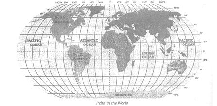
India is a vast country. LYING ENTIRELY IN THE Northern hemisphere the main land extends between latitudes 8o4’ N and 37o 6’ and longitudes 68o 7’ E 97o 25’ E. the Tropic of Cancer (23o 30’N) divides the country into almost two equal parts. To the southeast and southwest of the mainland, lie the Andaman and Nicobar islands in Bay of Bengal and the Lakshadweep islands in the Arabian Sea.
SIZE
the land mass of India has an area of 3.28 million square km. India’s total areas accounts for about 2.4 per cent of the total geographical area of the world. India is the seventh largest country of the world. India has a land boundary of about 15200 km and the total length of the coast line of the mainland including Andaman and
Nicobar and Lakshadweep is 7516.6 km.
(a) India has a distinct physical and cultural identity:
Notwithstanding wide diversity, the Indian society has fostered unity and homogeneity. To a large extent this unity and homogeneity has been promoted by the geographical features of the country.
(i) On its north, India is bounded by lofty mountains. These mountains run east-west for thousands of kilometers. These provide a natural wall against all possible intrusions.
(ii) On the south, India is surrounded by the seas and the ocean from three sides. It means, the land is protected from outside intrusions.
Theses geographical features have ensured that:
(i) people from outside could come only through well-defined routes, whether by sea or through passes in mountains.
(ii) People who came from outside brought with them their cultural elements. these elements came to be assimilated in Indian culture.
(iii) Indian society adapted itself to the new norms.
(iv) Thus, by adopting new norms and values and accepting them as their own, unity and homogeneity came to ‘be promoted.
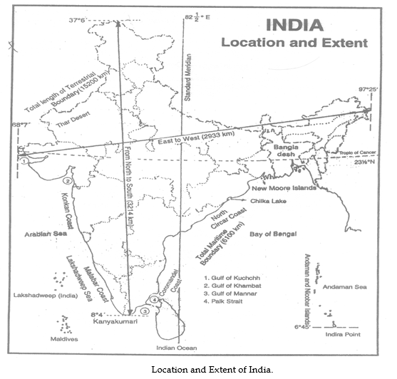
(b) “The north-south extent of India is larger than its east-west extent even through the country’s latitudinal and longitudinal extent in degree es is of the same value.”
The north-south distance between two successive latitudes remains the same or constant, and it is 3214 km is this case. But the east-west distance between the two successive longitudes goes on progressively decreasing from the equator to the poles. This is because all the meridians merge into a single point at the poles. in India the maximum east-west extent therefore is much less than km. it is 2933 km only.
(c) Impact of the longitudinal extent of India:
The earth takes 24 hours to corrupted one rotation (360o) about its axis. It means the earth rotates at the pace of 15 per hour (360o / 24) As the longitudinal extent of India is about 30o longitude the time lag between easternmost and westernmost points of India is of two hours. When it is 6.00 a.m at eastern
extremity of India it is still 4.00 a.m. at the westernmost point of India. To avoid this time confusion, time along the Standard Meridian of India (82o 30’E) passing through Mizapur (in Uttar Pradesh) is taken as the standard time for the whole country. the latitude with an odd value of 82o 30’E has been selected as the Standard Meridian of India as –
(i) It is well divisible by 7 o 30’, a standard adopted by almost all the countries of the world.
(ii) It lies almost in the middle of India, and as such, it suits us the most.
(d) Impact of the Latitudinal extent of India:
Kanyakumari is situated near Equator. here days and nights are almost equal, the maximum difference is 45 minutes only. but as we move farther towards north or south of the Equator, the difference between the length of the day and night becomes progressively larger. in north Kashmir it is as much as 5 hours, as it is far away from the equator.
INDIA AND THE WORLD
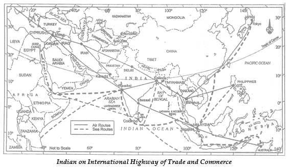
(a) Significance of India’s Location:
(i) Very thickly populated parts of the world such as China, Japan and Southeast Asia lie very close to India. This has helped in developing trade and other relations with them.
(ii) The oil rich countries of the Persian Gulf not far from us. we receive bulk of our supplies from them.
(iii) Being at the head of the Indian Ocean, the country occupies a strategic position and commercially favorable location in respect of Africa, Asia Australia.
(iv) The Suez sea-route provides us the shortest route to industrial Europe and America.
(v) The busy air-routes pass through India, connecting east, South East Asia and Australia on the one hand and Europe and America on the other.
(vi) The third largest ocean in the world came to be known as the Indian Ocean because the subcontinent of India stands at the head of this ocean. India was the favorite destination of the traders of the world.
(b) India’s Contacts with the outside World in Ancient and Medieval Times:
India belongs to the Eastern Hemisphere, which contains the oriental world. In ancient times, the sea played an important role in determining the nature of interaction. The central location of India at the head of the Indian Ocean was of great advantage. Countries of East Africa, West Asia, South and South-East
Asia , and East Asia could reached be through sea routes. Hence, India established close cultural and commercial contacts with these countries.
India’s contacts with the outside world have continued through the ages:
(i) The exchanges of ideas and commodities dates back to the ancient times.
(ii) The ideas of the Upanishads, and the Ramayana, the stories of Panchatantras, the Indian numerals and the decimal system could reach many parts of the world.
(iii) The spices, muslin and other Indian goods were taken to different countries.]
(iv) The influence of Greek sculpture, and the architectural styles of dome and minarets from West Asia can be seen in India.
INDIA’S NEGIGHBOLIRS
To the north of India are China, Nepal and Bhutan, and to the east, Bangladesh and Myanmar, to the west and northwest are Pakistan and Afghanistan. In the south, separated from India by the Palk Strait, lies the island country of Sri Lanka. To the south of Lakshadweep lies Maldives, Not far the Andaman and Nicobar islands lie our closest South-East Asian neighbours: Indonesia, Malaysia and Thailand.
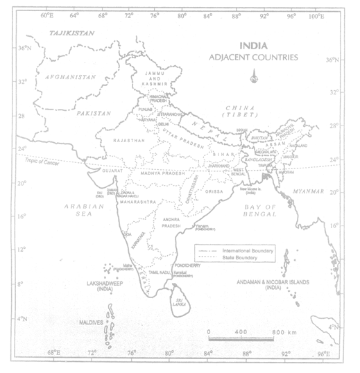
India and Adjacent Countries
(a) The Indian Subcontinent:
India is called a subcontinent because of its vastness and distinct physical and cultural identity. The countries that form the Indian subcontinent are Pakistan in the northwest, India at the core, Nepal in the north, Bhutan in the northeast and Bangladesh in the east.
SOME INTERESTING KNOWLWDGE
(i) The southernmost point of the Indian Union – ‘Indira Point’ got submerged under the sea water in 2004 during the Tsunami.
(ii) Since the opening of the Suez Canal in 1869, India’s distance from Europe has been reduced by 7000 km.
(iii) Before 1947, there were two types of states in India – the provinces and the princely states. Provinces were ruled directly by British officials who were appointed by the Viceroy. Princely states were ruled by local, hereditary rulers, who acknowledged sovereignty in return for local autonomy.
Question : Choose the right answer from the four alternatives given below.
(i) The Tropic of Cancer does not pass through
(a) Rajasthan
(b) Orissa
(c) Chhattisgarh
(d) Tripura
Answer: (b) Orissa
(ii) The easternmost longitude of India is
(a) 97∘25′E
(b) 68∘7′E
(c) 77∘6′E
(d) 82∘32′E
Answer: (a) 97∘25′E
(iii) Uttaranchal, Uttar Pradesh, Bihar, West Bengal and Sikkim have common frontiers with
(a) China
(b) Bhutan
(c) Nepal
(d) Myanmar
Answer: (c) Nepal
(iv) If you intend to visit Kavarati during your summer vacations, which one of the following Union Territories of India you will be going to
(a) Pondicherry
(b) Lakshadweep
(c) Andaman and Nicobar
(d) Diu and Daman
Answer: (b) Lakshadweep
(v) My friend hails from a country which does not share land boundary with India. Identify the country.
(a) Bhutan
(b) Tajikistan
(c) Bangladesh
(d) Nepal
Answer: (b) Tajikistan
Question : Answer the following questions briefly.
(i) Name the group of islands lying in the Arabian Sea.
(ii) Name the countries which are larger than India.
(iii) Which island group of India lies to its south-east?
(iv) Which island countries are our southern neighbours?
Answer :
(i) Lakshadweep
(ii) Russia, Canada, China, USA, Brazil and Australia.
(iii) Andaman and Nicobar group of islands.
(iv) Maldives, Sri Lanka.
Question :The sun rises two hours earlier in Arunachal Pradesh as compared to Gujarat in the west but the watches show the same time. How does this happen?
Answer : From the longitudinal extent of India it is observed that the longitudinal expanse is about 30O from west to east. This means that there would be a time-lag of two hours approximately from Gujarat to Arunachal Pradesh. To avoid such differences in local time, Indian standard time has been fixed to give the whole country a uniform time. The local time of the Standard Meridian of 82O30’E is observed as the Standard Time by the whole country. Because of this reason we find that the sun rises two hours earlier in Arunachal Pradesh as compared to Gujarat in the west but the watches show the same time.
Question : The central location of India at the head of the Indian Ocean is considered of great significance.Why?
Answer : The central location of India at the head of the Indian Ocean is considered of great significance because:
a) It has given India a strategic advantage due to the Trans Indian ocean routes which connect the countries of Europe in the West and the countries of East Asia.
b) This helps India to establish close contact with West Asia, Africa and Europe from the Western coast and with the Southeast and East Asia from the Eastern coast.
c) The vast coastline and the natural harbours have benefitted India in carrying out trade and commerce with its neighbouring and distant countries since ancient times.
d) It has given India a distinct climate than the rest of the Asian Continent.
e) No other country has such a long coastline on the Indian Ocean as India. It is India’s eminent position in the Indian Ocean which has given the name of an Ocean after it.
Question. Write the latitudinal and longitudinal extent of India.
Ans. Latitudinal extent: 8°4´N to 37°6´N
Longitudinal extent: 68°7´E to 97°25´E
Question. Which latitude and longitude divides India almost into two equal halves?
Ans. Latitude – Tropic of Cancer, 23°30´N
Longitude – Indian Standard Meridian, 82°30´E
Question. Name the island groups situated to the southeast and southwest of the mainland.
Ans. Southeast – Andaman and Nicobar islands
Southwest – Lakshadweep
Question. List the dimensions of the following:
Ans. a. Land boundary of India: 15,200 km
b. Length of coastline: 7516.6 km (including the islands)
c. Area of mainland: 3.28 million sq. km.
d. North-south extent: 3214 km
e. East-west extent: 2933 km
Question. Name the southern neighbours of India across the sea.
Ans. Sri Lanka and Maldives.
Question. Identify the countries constituting the Indian subcontinent.
Ans. 1. India in the center
2. Pakistan in North-west
3. Nepal in the North
4. Bhutan in North-east
5. Bangladesh in east
Question. Name the countries that share their land boundaries with India.
Ans. 1. Pakistan 2. Afghanistan 3. China 4. Nepal
5. Bhutan 6. Bangladesh 7. Myanmar
Question. Why is Indian sub-continent so called?
Ans. India and the adjoining countries are considered to be a sub-continent as it comprises of all the characteristics of a continent.
• Indian sub-continent encompasses vast areas of diverse landmasses. Indian subcontinent comprises of lofty mountains, fertile plains, desert and plateau.
• There is also great vastness and diversities in terms of climate, natural vegetation, wildlife and other resources.
• Also, the vivid characteristics of culture and tradition among the people make it a subcontinent.
Question. “India lies to the North-eastern Hemisphere.” Justify the given statement.
Ans. 1. India lies to the east of Prime meridian between the longitudes 68°7´E to 97025’E.
2. Also, India lies to the North of equator between the latitudes 8°4´N to 37°6´N.
3. Important lines like Tropic of Cancer, 23030´N and Indian Standard Meridian, 82030’E pass through India.
Hence, all this proves that India lies in the North-eastern hemisphere.
Question. How do we calculate the time difference from Arunachal Pradesh to Gujarat?
Ans. Sun rays take 4 minutes to cover one longitude. From Arunachal Pradesh to Gujarat there are 30 longitudes (68°7´E to 97°25´E)
Calculation
Time taken by light to cross a longitude = 4 min
Time taken by light to cross 30 longitudes = 4X30= 120 min or 2 hours.
Hence, we can say that the time difference of 2 hours exists from Arunachal Pradesh to Gujarat.
Question. Inspite of the time differences, how does India adopt a uniform time?
Ans. India has a uniform time because we have adopted 82030’ longitude passing through Mirzapur near Allahabad as the standard meridian. Therefore, time along this meridian is accepted as the standard time for whole country. This is done to avoid any confusion that may arise due to difference in time as a result of vast longitudinal extent of India.
Question. The central location of India at the head of the Indian Ocean is considered of great significance. Why?
Ans. 1. The Indian landmass has the central location between the East and the West Asia. The Trans Indian Ocean routes connect the countries of Europe in the west and the countries of East Asia.
2. The Deccan Peninsula in the Indian Ocean helps to establish close contacts from the western coastal plains and the eastern coastal plains.
3. The long coastline of the country in the Indian Ocean gives it an eminent position which justifies the name of the ocean.
Question. How can you say that the land routes of India with other countries are older than her maritime routes?
Ans. 1. The various passes across the mountains in the north have provided passages to the travellers when the oceans restricted such an interaction for a long time.
2. These routes have contributed in the exchange of ideas and commodities in the ancient times like the ideas of the Upnishads, Ramayana, The Indian numerals and the decimal system.\
3. Also, the influence of Greek sculpture, and the architectural styles of domes and minarets can be seen in the different parts of our country.
Therefore, we can say that the land routes of India with other countries are older
than her maritime routes.
Question. Why the difference between the duration of day and night hardly felt at Kanyakumari but not so in Kashmir?
Ans. 1. Due to the vast latitudinal extent of India, the difference between the duration of day and night is hardly felt at Kanyakumari but not so in Kashmir.
2. The tropic of Cancer divides the country almost into tropical and sub-tropical zone.
3. Since, Kanyakumari lies in the tropical zone, therefore, the duration of day and night is not so felt and Kashmir lying in the sub-tropical zone, we do experience the difference of day and night.
| CBSE Class 9 Social Science Story Of Village Palampur Notes |
| CBSE Class 9 Social Science People As Resource Chapter Notes |
| CBSE Class 9 Social Science Poverty As a Challenge Notes |
| CBSE Class 9 Social Science Food Security Chapter Notes |
| CBSE Class 9 Social Science India Size And Location Chapter Notes |
| CBSE Class 9 Social Science Physical Features Of India Chapter Notes |
| CBSE Class 9 Social Science Drainage Notes |
| CBSE Class 9 Social Science Climate Chapter Notes |
| CBSE Class 9 Social Science Natural Vegetation And Wildlife Chapter Notes |
| CBSE Class 9 Social Science Population Chapter Notes |
| CBSE Class 9 Social Science What Is Democracy Why Democracy Chapter Notes |
| CBSE Class 9 Social Science Constitutional Design Notes |
| CBSE Class 9 Social Science Electoral Politics Chapter Notes |
| CBSE Class 9 Social Science Working of Institutions Chapter Notes |
| CBSE Class 9 Social Science Democratic Rights Notes |
| CBSE Class 9 Social Science The French Revolution Notes |
| CBSE Class 9 Social Science Socialism in Europe and the Russian Revolution Chapter Notes |
| CBSE Class 9 Social Science Nazism And The Rise Of Hitler Notes |
| CBSE Class 9 Social Science Forest Society And Colonialism Chapter Notes |
| CBSE Class 9 Social Science Pastoralists In The Modern world Chapter Notes |
More Study Material
CBSE Class 9 Social Science Contemporary India Chapter 1 India Size and Location Notes
We hope you liked the above notes for topic Contemporary India Chapter 1 India Size and Location which has been designed as per the latest syllabus for Class 9 Social Science released by CBSE. Students of Class 9 should download and practice the above notes for Class 9 Social Science regularly. All revision notes have been designed for Social Science by referring to the most important topics which the students should learn to get better marks in examinations. Studiestoday is the best website for Class 9 students to download all latest study material.
Notes for Social Science CBSE Class 9 Contemporary India Chapter 1 India Size and Location
Our team of expert teachers have referred to the NCERT book for Class 9 Social Science to design the Social Science Class 9 notes. If you read the concepts and revision notes for one chapter daily, students will get higher marks in Class 9 exams this year. Daily revision of Social Science course notes and related study material will help you to have a better understanding of all concepts and also clear all your doubts. You can download all Revision notes for Class 9 Social Science also from www.studiestoday.com absolutely free of cost in Pdf format. After reading the notes which have been developed as per the latest books also refer to the NCERT solutions for Class 9 Social Science provided by our teachers
Contemporary India Chapter 1 India Size and Location Notes for Social Science CBSE Class 9
All revision class notes given above for Class 9 Social Science have been developed as per the latest curriculum and books issued for the current academic year. The students of Class 9 can rest assured that the best teachers have designed the notes of Social Science so that you are able to revise the entire syllabus if you download and read them carefully. We have also provided a lot of MCQ questions for Class 9 Social Science in the notes so that you can learn the concepts and also solve questions relating to the topics. All study material for Class 9 Social Science students have been given on studiestoday.
Contemporary India Chapter 1 India Size and Location CBSE Class 9 Social Science Notes
Regular notes reading helps to build a more comprehensive understanding of Contemporary India Chapter 1 India Size and Location concepts. notes play a crucial role in understanding Contemporary India Chapter 1 India Size and Location in CBSE Class 9. Students can download all the notes, worksheets, assignments, and practice papers of the same chapter in Class 9 Social Science in Pdf format. You can print them or read them online on your computer or mobile.
Notes for CBSE Social Science Class 9 Contemporary India Chapter 1 India Size and Location
CBSE Class 9 Social Science latest books have been used for writing the above notes. If you have exams then you should revise all concepts relating to Contemporary India Chapter 1 India Size and Location by taking out a print and keeping them with you. We have also provided a lot of Worksheets for Class 9 Social Science which you can use to further make yourself stronger in Social Science
You can download notes for Class 9 Social Science Contemporary India Chapter 1 India Size and Location for latest academic session from StudiesToday.com
Yes, you can click on the link above and download notes PDFs for Class 9 Social Science Contemporary India Chapter 1 India Size and Location which you can use for daily revision
Yes, the notes issued for Class 9 Social Science Contemporary India Chapter 1 India Size and Location have been made available here for latest CBSE session
You can easily access the link above and download the Class 9 Notes for Social Science Contemporary India Chapter 1 India Size and Location for each topic in Pdf
There is no charge for the notes for CBSE Class 9 Social Science Contemporary India Chapter 1 India Size and Location, you can download everything free of charge
www.studiestoday.com is the best website from which you can download latest notes for Contemporary India Chapter 1 India Size and Location Social Science Class 9
Come to StudiesToday.com to get best quality topic wise notes for Class 9 Social Science Contemporary India Chapter 1 India Size and Location
We have provided all notes for each topic of Class 9 Social Science Contemporary India Chapter 1 India Size and Location as per latest CBSE syllabus